Parcul castelului Kendi-Kemény din Brâncovenești, județul...
14
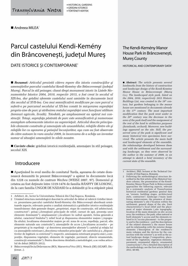
2017/1 46 Transsylvania Nostra n Rezumat: Articolul prezintă câteva repere din istoria construcþiilor şi amenajărilor parcului castelului Kendi-Kemény din Brâncoveneşti (judeþul Mureş). Parcul în stil peisager, clasat drept monument istoric în Listele Mo- numentelor Istorice 2004, 2010, respectiv 2015, a fost creat în secolul al XIX-lea, dar grădini aferente castelului sunt amintite în documente încă din secolul al XVII-lea. Cea mai semnificativă modificare pe care parcul a suferit-o pe parcursul secolului al XX-lea constă în micşorarea suprafeþei propriu-zise de parc şi atribuirea restului suprafeþei unor funcþiuni utilitare (terenuri agricole, livadă). Totodată, pe amplasament au apărut noi con- strucþii. Totuşi, suprafaþa păstrată de parc este semnificativă şi numeroase exemplare arborescente istorice au supravieþuit. Articolul descrie principa- lele elemente construite şi amenajate ale ansamblului, relaþiile dintre ele şi relaþiile lor cu aşezarea şi peisajul înconjurător, aşa cum au fost observate de către autoare în vara anului 2009, în încercarea de a schiþa un inventar sumar al situaþiei amenajării în zilele noastre. n Cuvinte cheie: grădină istorică rezidenþială, amenajare în stil peisager, secolul XIX Introducere n Aparþinând în evul mediu de comitatul Turda, aşezarea de cetate dom- nească denumită în prezent Brâncoveneşti 3 a apărut în documente încă din 1228 cu numele de castrum Wecheu (WEISZ 2007, 97). Domeniul şi cetatea au fost deþinute între 1319-1476 de familia BÁNFFY DE LOSONC, de la care familia UNGOR DE NÁDASD le-a dobândit şi le-a stăpânit până 1 Arhitect. dr., lector la Universitatea Tehnică din Cluj-Napoca, România. 2 Urmând structura metodologică descrisă în articolul de debut al rubricii Grădini Istori- ce, prezentarea parcului castelului Kendi-Kemény din Brâncoveneşti abordează urmă- toarele aspecte, relevante pentru o analiză sistematică a grădinilor istorice rezidenþiale transilvănene: date generale despre „proprietari, etape de construcþie, stil arhitectural, constructori”; peisaj („formaþiuni principale de relief, cursuri de apă, prezenþa unor elemente dominante”); amplasament („localizare în cadrul aşezării, forma generală a sitului, caracterul limitelor”); relief local şi dispunerea elementelor majore („topogra- fia sitului, localizarea elementelor majore pe sit: zona de acces, reşedinþa, parcul, alte elemente naturale sau construite”); amenajările de acces („localizarea acceselor – pe proprietate şi în reşedinþă – şi descrierea amenajărilor aferente”); castelul şi relaþia lui cu amenajările exterioare („descrierea volumelor principale” ale castelului şi a „dispozi- tivelor de legătură cu exteriorul”); respectiv, amenajarea exterioară propriu-zisă („com- poziþie, dispunerea vegetaþiei, elemente de vegetaþie, paviment, obiecte ornamentale, construcþii ornamentale”). Pentru descrierea detaliată a metodologiei, a se vedea artico- lul de debut (MILEA 2012). 3 Brâncoveneşti/Ieciu/Delavrancea (RO), Marosvécs/Vécs (HU), Wetsch (DE) (SZABÓ, Dic- ţionar...). n Abstract: The article presents several landmarks from the history of construction and landscape design of the Kendi-Kemény Manor House in Brâncoveneşti (Mureş Co.). The landscaped style park, listed on the 2004, 2010, respectively 2015 Historic Buildings List, was created in the 19 th cen- tury, but gardens belonging to the manor house are mentioned in documents already in the 17 th century. The most important modification that the park went under in the 20 th century was the decrease in the area of the park itself and the assignment of the rest of the land to utilitarian purposes (farmlands, orchard). Moreover, new build- ings appeared on the site. Still, the pre- served area of the park is significant and many historical tree specimens have sur- vived. The article presents the main built and landscaped elements of the ensemble, the relationships developed between them and with the settlement and the surround- ing landscape, as they were observed by the author in the summer of 2009, in an attempt to sketch a brief inventory of the current state of the ensemble. 1 Architect, PhD, lecturer at the Technical Uni- versity of Cluj-Napoca, Romania. 2 Following the methodological structure de- scribed in the first article of the Historical Gar- dens column, the presentation of the Kendi- Kemény Manor House Park in Brâncoveneşti approaches the following aspects, relevant for a systematic analysis of Transylvanian historical residential gardens: general data on “owners, building stages, architectural style, contractors”; landscape (“main land- forms, watercourses, the presence of domi- nating elements”); site (“location within the settlement, general shape of the site, limit characteristics”); local relief and the place- ment of major elements („site topography, location of the main elements on site: access area, the residence, the park, other natural or built elements”); access and the elements re- lated to it (“access placement – to the proper- ty and to the residence – and the descriptions of the related elements”); the manor house and its relationship with the exterior design elements (“description of the residence’s main volumes and the devices for the con- nection with the exterior”); as well as the ac- tual landscape design (“composition, place- ment of the vegetation, vegetation elements, pavement, ornamental objects, ornamental constructions”). For a detailed description of the methodology, see the first article (MILEA 2012, 48-60). n Andreea MILEA 1 Parcul castelului Kendi-Kemény din Brâncovenești, județul Mureș DATE ISTORICE ŞI CONTEMPORANE 2 The Kendi-Kemény Manor House Park in Brâncovenești, Mureș County HISTORICAL AND CONTEMPORARY DATA 2 n HISTORICAL GARDENS n GRĂDINI ISTORICE n TÖRTÉNETI KERTEK
Transcript of Parcul castelului Kendi-Kemény din Brâncovenești, județul...
2017/146
Transsylvania Nostra
n Rezumat: Articolul prezintă câteva repere din istoria construcþiilor şi amenajărilor parcului castelului Kendi-Kemény din Brâncoveneşti (judeþul Mureş). Parcul în stil peisager, clasat drept monument istoric în Listele Mo-numentelor Istorice 2004, 2010, respectiv 2015, a fost creat în secolul al XIX-lea, dar grădini aferente castelului sunt amintite în documente încă din secolul al XVII-lea. Cea mai semnificativă modificare pe care parcul a suferit-o pe parcursul secolului al XX-lea constă în micşorarea suprafeþei propriu-zise de parc şi atribuirea restului suprafeþei unor funcþiuni utilitare (terenuri agricole, livadă). Totodată, pe amplasament au apărut noi con-strucþii. Totuşi, suprafaþa păstrată de parc este semnificativă şi numeroase exemplare arborescente istorice au supravieþuit. Articolul descrie principa-lele elemente construite şi amenajate ale ansamblului, relaþiile dintre ele şi relaþiile lor cu aşezarea şi peisajul înconjurător, aşa cum au fost observate de către autoare în vara anului 2009, în încercarea de a schiþa un inventar sumar al situaþiei amenajării în zilele noastre.
n Cuvinte cheie: grădină istorică rezidenþială, amenajare în stil peisager, secolul XIX
Introducere
n Aparþinând în evul mediu de comitatul Turda, aşezarea de cetate dom-nească denumită în prezent Brâncoveneşti3 a apărut în documente încă din 1228 cu numele de castrum Wecheu (WEISZ 2007, 97). Domeniul şi cetatea au fost deþinute între 1319-1476 de familia BÁNFFY DE LOSONC, de la care familia UNGOR DE NÁDASD le-a dobândit şi le-a stăpânit până
1 Arhitect. dr., lector la Universitatea Tehnică din Cluj-Napoca, România.2 Urmând structura metodologică descrisă în articolul de debut al rubricii Grădini Istori-
ce, prezentarea parcului castelului Kendi-Kemény din Brâncoveneşti abordează urmă-toarele aspecte, relevante pentru o analiză sistematică a grădinilor istorice rezidenþiale transilvănene: date generale despre „proprietari, etape de construcþie, stil arhitectural, constructori”; peisaj („formaþiuni principale de relief, cursuri de apă, prezenþa unor elemente dominante”); amplasament („localizare în cadrul aşezării, forma generală a sitului, caracterul limitelor”); relief local şi dispunerea elementelor majore („topogra-fia sitului, localizarea elementelor majore pe sit: zona de acces, reşedinþa, parcul, alte elemente naturale sau construite”); amenajările de acces („localizarea acceselor – pe proprietate şi în reşedinþă – şi descrierea amenajărilor aferente”); castelul şi relaþia lui cu amenajările exterioare („descrierea volumelor principale” ale castelului şi a „dispozi-tivelor de legătură cu exteriorul”); respectiv, amenajarea exterioară propriu-zisă („com-poziþie, dispunerea vegetaþiei, elemente de vegetaþie, paviment, obiecte ornamentale, construcþii ornamentale”). Pentru descrierea detaliată a metodologiei, a se vedea artico-lul de debut (MILEA 2012).
3 Brâncoveneşti/Ieciu/Delavrancea (RO), Marosvécs/Vécs (HU), Wetsch (DE) (SZABÓ, Dic -ţionar...).
n Abstract: The article presents several landmarks from the history of construction and landscape design of the Kendi-Kemény Manor House in Brâncoveneşti (Mureş Co.). The landscaped style park, listed on the 2004, 2010, respectively 2015 Historic Buildings List, was created in the 19th cen-tury, but gardens belonging to the manor house are mentioned in documents already in the 17th century. The most important modification that the park went under in the 20th century was the decrease in the area of the park itself and the assignment of the rest of the land to utilitarian purposes (farmlands, orchard). Moreover, new build-ings appeared on the site. Still, the pre-served area of the park is significant and many historical tree specimens have sur-vived. The article presents the main built and landscaped elements of the ensemble, the relationships developed between them and with the settlement and the surround-ing landscape, as they were observed by the author in the summer of 2009, in an attempt to sketch a brief inventory of the current state of the ensemble.
1 Architect, PhD, lecturer at the Technical Uni-versity of Cluj-Napoca, Romania.
2 Following the methodological structure de-scribed in the first article of the Historical Gar-dens column, the presentation of the Kendi- Kemény Manor House Park in Brâncoveneşti approaches the following aspects, relevant for a systematic analysis of Transylvanian historical residential gardens: general data on “owners, building stages, architectural style, contractors”; landscape (“main land-forms, watercourses, the presence of domi-nating elements”); site (“location within the settlement, general shape of the site, limit characteristics”); local relief and the place-ment of major elements („site topography, location of the main elements on site: access area, the residence, the park, other natural or built elements”); access and the elements re-lated to it (“access placement – to the proper-ty and to the residence – and the descriptions of the related elements”); the manor house and its relationship with the exterior design elements (“description of the residence’s main volumes and the devices for the con-nection with the exterior”); as well as the ac-tual landscape design (“composition, place-ment of the vegetation, vegetation elements, pavement, ornamental objects, ornamental constructions”). For a detailed description of the methodology, see the first article (MILEA 2012, 48-60).
n Andreea MILEA1
Parcul castelului Kendi-Kemény din Brâncovenești, județul MureșDATE ISTORICE ŞI CONTEMPORANE2
The Kendi-Kemény Manor House Park in Brâncovenești, Mureș County
HISTORICAL AND CONTEMPORARY DATA2
n HISTORICAL GARDENS n GRĂDINI ISTORICE n TÖRTÉNETI KERTEK
2017/1 47
Transsylvania Nostra
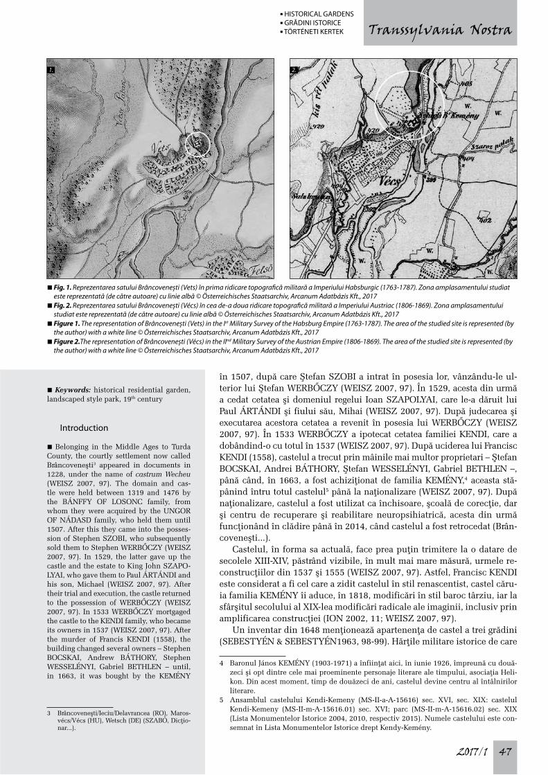
în 1507, după care Ştefan SZOBI a intrat în posesia lor, vânzându-le ul-terior lui Ştefan WERBŐCZY (WEISZ 2007, 97). În 1529, acesta din urmă a cedat cetatea şi domeniul regelui Ioan SZAPOLYAI, care le-a dăruit lui Paul ÁRTÁNDI şi fiului său, Mihai (WEISZ 2007, 97). După judecarea şi executarea acestora cetatea a revenit în posesia lui WERBŐCZY (WEISZ 2007, 97). În 1533 WERBŐCZY a ipotecat cetatea familiei KENDI, care a dobândind-o cu totul în 1537 (WEISZ 2007, 97). După uciderea lui Francisc KENDI (1558), castelul a trecut prin mâinile mai multor proprietari – Ştefan BOCSKAI, Andrei BÁTHORY, Ştefan WESSELÉNYI, Gabriel BETHLEN –, până când, în 1663, a fost achiziþionat de familia KEMÉNY,4 aceasta stă-pânind întru totul castelul5 până la naþionalizare (WEISZ 2007, 97). După naþionalizare, castelul a fost utilizat ca închisoare, şcoală de corecþie, dar şi centru de recuperare şi reabilitare neuropsihiatrică, acesta din urmă funcþionând în clădire până în 2014, când castelul a fost retrocedat (Brân-coveneşti...).
Castelul, în forma sa actuală, face prea puþin trimitere la o datare de secolele XIII-XIV, păstrând vizibile, în mult mai mare măsură, urmele re-construcþiilor din 1537 şi 1555 (WEISZ 2007, 97). Astfel, Francisc KENDI este considerat a fi cel care a zidit castelul în stil renascentist, castel căru-ia familia KEMÉNY îi aduce, în 1818, modificări în stil baroc târziu, iar la sfârşitul secolului al XIX-lea modificări radicale ale imaginii, inclusiv prin amplificarea construcþiei (ION 2002, 11; WEISZ 2007, 97).
Un inventar din 1648 menþionează apartenenþa de castel a trei grădini (SEBESTYÉN & SEBESTYÉN1963, 98-99). Hărþile militare istorice de care
4 Baronul János KEMÉNY (1903-1971) a înfiinţat aici, în iunie 1926, împreună cu două-zeci şi opt dintre cele mai proeminente personaje literare ale timpului, asociaţia Heli-kon. Din acest moment, timp de douăzeci de ani, castelul devine centru al întâlnirilor literare.
5 Ansamblul castelului Kendi-Kemeny (MS-II-a-A-15616) sec. XVI, sec. XIX: castelul Kendi-Kemeny (MS-II-m-A-15616.01) sec. XVI; parc (MS-II-m-A-15616.02) sec. XIX (Lista Monumentelor Istorice 2004, 2010, respectiv 2015). Numele castelului este con-semnat în Lista Monumentelor Istorice drept Kendy-Kemény.
n Keywords: historical residential garden, landscaped style park, 19th century
Introduction
n Belonging in the Middle Ages to Turda County, the courtly settlement now called Brâncoveneşti3 appeared in documents in 1228, under the name of castrum Wecheu (WEISZ 2007, 97). The domain and cas-tle were held between 1319 and 1476 by the BÁNFFY OF LOSONC family, from whom they were acquired by the UNGOR OF NÁDASD family, who held them until 1507. After this they came into the posses-sion of Stephen SZOBI, who subsequently sold them to Stephen WERBŐCZY (WEISZ 2007, 97). In 1529, the latter gave up the castle and the estate to King John SZAPO-LYAI, who gave them to Paul ÁRTÁNDI and his son, Michael (WEISZ 2007, 97). After their trial and execution, the castle returned to the possession of WERBŐCZY (WEISZ 2007, 97). In 1533 WERBŐCZY mortgaged the castle to the KENDI family, who became its owners in 1537 (WEISZ 2007, 97). After the murder of Francis KENDI (1558), the building changed several owners – Stephen BOCSKAI, Andrew BÁTHORY, Stephen WESSELÉNYI, Gabriel BETHLEN – until, in 1663, it was bought by the KEMÉNY
3 Brâncoveneşti/Ieciu/Delavrancea (RO), Maros-vécs/Vécs (HU), Wetsch (DE) (SZABÓ, Dic ţio-nar...).
n Fig. 1. Reprezentarea satului Brâncovenești (Vets) în prima ridicare topografică militară a Imperiului Habsburgic (1763-1787). Zona amplasamentului studiat este reprezentată (de către autoare) cu linie albă © Österreichisches Staatsarchiv, Arcanum Adatbázis Kft., 2017
n Fig. 2. Reprezentarea satului Brâncovenești (Vécs) în cea de-a doua ridicare topografică militară a Imperiului Austriac (1806-1869). Zona amplasamentului studiat este reprezentată (de către autoare) cu linie albă © Österreichisches Staatsarchiv, Arcanum Adatbázis Kft., 2017
n Figure 1. The representation of Brâncovenești (Vets) in the Ist Military Survey of the Habsburg Empire (1763-1787). The area of the studied site is represented (by the author) with a white line © Österreichisches Staatsarchiv, Arcanum Adatbázis Kft., 2017
n Figure 2.The representation of Brâncovenești (Vécs) in the IInd Military Survey of the Austrian Empire (1806-1869). The area of the studied site is represented (by the author) with a white line © Österreichisches Staatsarchiv, Arcanum Adatbázis Kft., 2017
1. 2.
n HISTORICAL GARDENS n GRĂDINI ISTORICE n TÖRTÉNETI KERTEK
2017/148
Transsylvania Nostra
dispunem încep să semnaleze grafic6 grădina castelului odată cu începu-tul secolului al XIX-lea.7 Faþă de întinderea iniþială a parcului peisager, aşa cum o aflăm reprezentată în hărþile istorice, suprafaþa actuală pe care au supravieþuit amenajările pentru destindere este mult micşorată, restul suprafeþei ajungând să fie destinată în timp unor funcþiuni utilitare, pre-cum terenuri agricole, livezi şi, mai recent, primind noi construcþii pentru programul medical mutat din castel.
Peisaj
n Brâncoveneşti, satul de reşedinþă al comunei cu acelaşi nume, este si-tuat în Subcarpaþii Transilvaniei, la limita estică a Podişului Transilvan, într-un peisaj caracterizat printr-o succesiune de depresiuni şi dealuri, un peisaj romanesc, după cum îl caracterizează József BIRÓ.8 Satul se află pe þărmul drept al râului Mureş, care trece la est de aşezare.
Amplasament
n Satul Brâncoveneşti se dezvoltă pe direcþia nord-est sud-vest, de-a lun-gul þărmului drept al râului Mureş, apropiindu-se de acesta în capătul nord-estic al satului, şi depărtându-se de el înspre sud-vest. Amplasa-
6 Şi textual în cartarea Regatului Maghiar (1869-1887).7 Avem documentată prezenþa grădinii în cea de-a doua ridicare topografică militară a
Imperiului Austriac (1806-1869), în cea de-a treia ridicare topografică militară a Austro-Ungariei (1869-1887), în cartarea Regatului Maghiar (1869-1887), şi în aşa-numita hartă militară a Ungariei din 1941. Întrucât denumirea acesteia din urmă, Military Survey of Hungary (1941) (Historical Maps...), este improprie, cuprinzând şi teritorii aflate la vremea respectivă în România, ne vom referi la ea, pe parcursul actualului studiu, mai simplu, drept harta militară din 1941.
8 „A legzordabb, legkomorabb valamennyi erdélyi kastély között Marosvécs vára, fenn a dombon, a Maros vize fölött, regényies tájképi háttér ölében” / „Cel mai sobru şi mai sumbru dintre toate castelele ardelene îl reprezintă cetatea din Brâncoveneşti, aflată în susul dealului, deasupra apelor Mureşului, în mijlocul unui peisaj romanesc” (traduce-rea autoarei) (BIRÓ 1944, 42).
family4, remaining in their ownership5 until the nationalisation (WEISZ 2007, 97). After the nationalisation, the manor house was used as a prison, a correctional, but also as a neuropsychiatric rehabilitation and recovery center, the latter operating in the building until 2014, when the manor house was restituted (Brâncoveneşti...).The manor house, in its current form, offers too little ground to a dating from the 13th and 14th centuries, preserving to a much larger ex-tent the traces of reconstructions from 1537 and 1555 (WEISZ 2007, 97). Thus, Francis KENDI is thought to be the one who built the Renaissance style manor house, to which the KEMÉNY family brought, in 1818, late Baroque changes and, at the end of the 19th century, radical alterations to its image, including by the building’s amplification (ION 2002, 11; WEISZ 2007, 97).An in-ventory from 1648 mentions three gardens belonging to the building (SEBESTYÉN & SEBESTYÉN1963, 98-99). The available military surveys start to signal graphically6 the manor house’s garden starting with the
4 Baron János Kemény (1903-1971) founded here in June 1926, along with twenty eight of the most prominent literary figures of the time, the Helikon association. From this mo-ment on, for twenty years, the manor house became a centre of literary meetings.
5 Kendi-Kemeny Manor House ensemble (MS-II-a-A-15616) 16th century, 19th century: Kendi-Kemeny Manor House (MS-II-m-A-15616.01) 16th century; park (MS-II-m-A-15616.02) 19th century (Historic Buildings List 2004, 2010, respectively 2015). The name of the manor house is recorded in the Historic Buildings List as Kendy-Kemény.
6 Also textually in the Mapping of the Kingdom of Hungary (1869-1887).
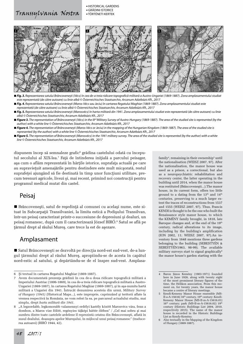
n Fig. 3. Reprezentarea satului Brâncovenești (Vécs) în cea de-a treia ridicare topografică militară a Austro-Ungariei (1869-1887). Zona amplasamentului studiat este reprezentată (de către autoare) cu linie albă © Österreichisches Staatsarchiv, Arcanum Adatbázis Kft., 2017
n Fig. 4. Reprezentarea satului Brâncovenești (Maros-Vécs sau Jeciu) în cartarea Regatului Maghiar (1869-1887). Zona amplasamentului studiat este reprezentată (de către autoare) cu linie albă © Österreichisches Staatsarchiv, Arcanum Adatbázis Kft., 2017
n Fig. 5. Reprezentarea satului Brâncovenești (Marosvécs) în harta militară din 1941. Zona amplasamentului studiat este reprezentată (de către autoare) cu linie albă © Österreichisches Staatsarchiv, Arcanum Adatbázis Kft., 2017
n Figure 3. The representation of Brâncovenești (Vécs) in the IIIrd Military Survey of Austro-Hungary (1869-1887). The area of the studied site is represented (by the author) with a white line © Österreichisches Staatsarchiv, Arcanum Adatbázis Kft., 2017
n Figure 4. The representation of Brâncovenești (Maros-Vécs or Jeciu) in the mapping of the Hungarian Kingdom (1869-1887). The area of the studied site is represented (by the author) with a white line © Österreichisches Staatsarchiv, Arcanum Adatbázis Kft., 2017
n Figure 5. The representation of Brâncovenești (Marosvécs) in the 1941 military survey. The area of the studied site is represented (by the author) with a white line © Österreichisches Staatsarchiv, Arcanum Adatbázis Kft., 2017
3. 4. 5.
n HISTORICAL GARDENS n GRĂDINI ISTORICE n TÖRTÉNETI KERTEK
2017/1 49
Transsylvania Nostra
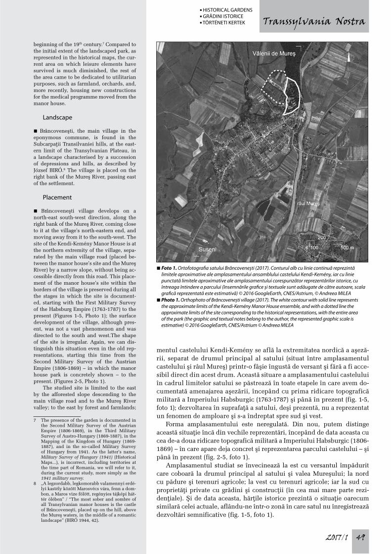
mentul castelului Kendi-Kemény se află la extremitatea nordică a aşeză-rii, separat de drumul principal al satului (situat între amplasamentul castelului şi râul Mureş) printr-o fâşie îngustă de versant şi fără a fi acce-sibil direct din acest drum. Această situare a amplasamentului castelului în cadrul limitelor satului se păstrează în toate etapele în care avem do-cumentată amenajarea aşezării, începând cu prima ridicare topografică militară a Imperiului Habsburgic (1763-1787) şi până în prezent (fig. 1-5, foto 1); dezvoltarea în suprafaþă a satului, deşi prezentă, nu a reprezentat un fenomen de amploare şi s-a îndreptat spre sud şi vest.
Forma amplasamentului este neregulată. Din nou, putem distinge această situaþie încă din vechile reprezentări, începând de data aceasta cu cea de-a doua ridicare topografică militară a Imperiului Habsburgic (1806-1869) – în care apare deja concret şi reprezentarea parcului castelului – şi până în prezent (fig. 2-5, foto 1).
Amplasamentul studiat se învecinează la est cu versantul împădurit care coboară la drumul principal al satului şi valea Mureşului; la nord cu pădure şi terenuri agricole; la vest cu terenuri agricole; iar la sud cu proprietăþi private cu grădini şi construcþii (în cea mai mare parte rezi-denþiale). Şi de data aceasta, hărþile istorice prezintă o situaþie oarecum similară celei actuale, aflându-ne într-o zonă în care satul nu înregistrează dezvoltări semnificative (fig. 1-5, foto 1).
beginning of the 19th century.7 Compared to the initial extent of the landscaped park, as represented in the historical maps, the cur-rent area on which leisure elements have survived is much diminished, the rest of the area came to be dedicated to utilitarian purposes, such as farmland, orchards, and, more recently, housing new constructions for the medical programme moved from the manor house.
Landscape
n Brâncoveneşti, the main village in the eponymous commune, is found in the Subcarpaþii Transilvaniei hills, at the east-ern limit of the Transylvanian Plateau, in a landscape characterised by a succession of depressions and hills, as described by József BIRÓ.8 The village is placed on the right bank of the Mureş River, passing east of the settlement.
Placement
n Brâncoveneşti village develops on a north-east south-west direction, along the right bank of the Mureş River, coming close to it at the village’s north-eastern end, and moving away from it to the south-west. The site of the Kendi-Kemény Manor House is at the northern extremity of the village, sepa-rated by the main village road (placed be-tween the manor house’s site and the Mureş River) by a narrow slope, without being ac-cessible directly from this road. This place-ment of the manor house’s site within the borders of the village is preserved during all the stages in which the site is document-ed, starting with the First Military Survey of the Habsburg Empire (1763-1787) to the present (Figures 1-5, Photo 1); the surface development of the village, although pres-ent, was not a vast phenomenon and was directed to the south and west.The shape of the site is irregular. Again, we can dis-tinguish this situation even in the old rep-resentations, starting this time from the Second Military Survey of the Austrian Empire (1806-1869) – in which the manor house park is concretely shown – to the present. (Figures 2-5, Photo 1).
The studied site is limited to the east by the afforested slope descending to the main village road and to the Mureş River valley; to the east by forest and farmlands;
7 The presence of the garden is documented in the Second Military Survey of the Austrian Empire (1806-1869), in the Third Military Survey of Austro-Hungary (1869-1887), in the Mapping of the Kingdom of Hungary (1869-1887), and in the so-called Military Survey of Hungary from 1941. As the latter’s name, Military Survey of Hungary (1941) (Historical Maps...), is incorrect, including territories at the time part of Romania, we will refer to it, during the current study, more simply as the 1941 military survey.
8 „A legzordabb, legkomorabb valamennyi erdé-lyi kastély között Marosvécs vára, fenn a dom-bon, a Maros vize fölött, regényies tájképi hát-tér ölében” / “The most sober and sombre of all Transylvanian manor houses is the castle of Brâncoveneşti, placed up on the hill, above the Mureş waters, in the middle of a romantic landscape” (BIRÓ 1944, 42).
n Foto 1. Ortofotografia satului Brâncovenești (2017). Conturul alb cu linie continuă reprezintă limitele aproximative ale amplasamentului ansamblului castelului Kendi-Kemény, iar cu linie punctată limitele aproximative ale amplasamentului corespunzător reprezentărilor istorice, cu întreaga întindere a parcului (însemnările grafice și textuale sunt adăugate de către autoare, scala grafică reprezentată este estimativă) © 2016 GoogleEarth, CNES/Astrium, © Andreea MILEA
n Photo 1. Orthophoto of Brâncovenești village (2017). The white contour with solid line represents the approximate limits of the Kendi-Kemény Manor House ensemble, and with a dotted line the approximate limits of the site corresponding to the historical representations, with the entire area of the park (the graphic and textual notes belong to the author, the represented graphic scale is estimative) © 2016 GoogleEarth, CNES/Astrium © Andreea MILEA
n HISTORICAL GARDENS n GRĂDINI ISTORICE n TÖRTÉNETI KERTEK
2017/150
Transsylvania Nostra
Relief local şi dispunerea elementelor majore
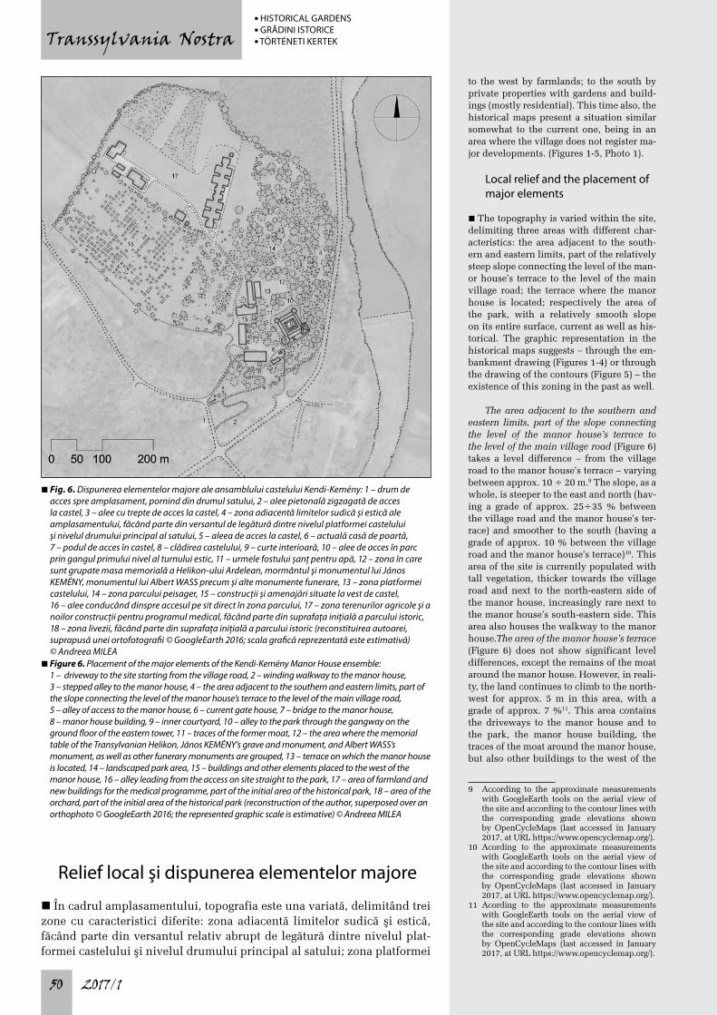
n În cadrul amplasamentului, topografia este una variată, delimitând trei zone cu caracteristici diferite: zona adiacentă limitelor sudică şi estică, făcând parte din versantul relativ abrupt de legătură dintre nivelul plat-formei castelului şi nivelul drumului principal al satului; zona platformei
to the west by farmlands; to the south by private properties with gardens and build-ings (mostly residential). This time also, the historical maps present a situation similar somewhat to the current one, being in an area where the village does not register ma-jor developments. (Figures 1-5, Photo 1).
Local relief and the placement of major elements
n The topography is varied within the site, delimiting three areas with different char-acteristics: the area adjacent to the south-ern and eastern limits, part of the relatively steep slope connecting the level of the man-or house’s terrace to the level of the main village road; the terrace where the manor house is located; respectively the area of the park, with a relatively smooth slope on its entire surface, current as well as his-torical. The graphic representation in the historical maps suggests – through the em-bankment drawing (Figures 1-4) or through the drawing of the contours (Figure 5) – the existence of this zoning in the past as well.
The area adjacent to the southern and eastern limits, part of the slope connecting the level of the manor house’s terrace to the level of the main village road (Figure 6) takes a level difference – from the village road to the manor house’s terrace – varying between approx. 10 ÷ 20 m.9 The slope, as a whole, is steeper to the east and north (hav-ing a grade of approx. 25÷35 % between the village road and the manor house’s ter-race) and smoother to the south (having a grade of approx. 10 % between the village road and the manor house’s terrace)10. This area of the site is currently populated with tall vegetation, thicker towards the village road and next to the north-eastern side of the manor house, increasingly rare next to the manor house’s south-eastern side. This area also houses the walkway to the manor house.The area of the manor house’s terrace (Figure 6) does not show significant level differences, except the remains of the moat around the manor house. However, in reali-ty, the land continues to climb to the north-west for approx. 5 m in this area, with a grade of approx. 7 %11. This area contains the driveways to the manor house and to the park, the manor house building, the traces of the moat around the manor house, but also other buildings to the west of the
9 According to the approximate measurements with GoogleEarth tools on the aerial view of the site and according to the contour lines with the corresponding grade elevations shown by OpenCycleMaps (last accessed in January 2017, at URL https://www.opencyclemap.org/).
10 Acording to the approximate measurements with GoogleEarth tools on the aerial view of the site and according to the contour lines with the corresponding grade elevations shown by OpenCycleMaps (last accessed in January 2017, at URL https://www.opencyclemap.org/).
11 Acording to the approximate measurements with GoogleEarth tools on the aerial view of the site and according to the contour lines with the corresponding grade elevations shown by OpenCycleMaps (last accessed in January 2017, at URL https://www.opencyclemap.org/).
n Fig. 6. Dispunerea elementelor majore ale ansamblului castelului Kendi-Kemény: 1 – drum de acces spre amplasament, pornind din drumul satului, 2 – alee pietonală zigzagată de acces la castel, 3 – alee cu trepte de acces la castel, 4 – zona adiacentă limitelor sudică și estică ale amplasamentului, făcând parte din versantul de legătură dintre nivelul platformei castelului și nivelul drumului principal al satului, 5 – aleea de acces la castel, 6 – actuală casă de poartă, 7 – podul de acces în castel, 8 – clădirea castelului, 9 – curte interioară, 10 – alee de acces în parc prin gangul primului nivel al turnului estic, 11 – urmele fostului șanț pentru apă, 12 – zona în care sunt grupate masa memorială a Helikon-ului Ardelean, mormântul şi monumentul lui János KEMÉNY, monumentul lui Albert WASS precum și alte monumente funerare, 13 – zona platformei castelului, 14 – zona parcului peisager, 15 – construcții și amenajări situate la vest de castel, 16 – alee conducând dinspre accesul pe sit direct în zona parcului, 17 – zona terenurilor agricole și a noilor construcții pentru programul medical, făcând parte din suprafața inițială a parcului istoric, 18 – zona livezii, făcând parte din suprafața inițială a parcului istoric (reconstituirea autoarei, suprapusă unei ortofotografii © GoogleEarth 2016; scala grafică reprezentată este estimativă) © Andreea MILEA
n Figure 6. Placement of the major elements of the Kendi-Kemény Manor House ensemble: 1 – driveway to the site starting from the village road, 2 – winding walkway to the manor house, 3 – stepped alley to the manor house, 4 – the area adjacent to the southern and eastern limits, part of the slope connecting the level of the manor house’s terrace to the level of the main village road, 5 – alley of access to the manor house, 6 – current gate house, 7 – bridge to the manor house, 8 – manor house building, 9 – inner courtyard, 10 – alley to the park through the gangway on the ground floor of the eastern tower, 11 – traces of the former moat, 12 – the area where the memorial table of the Transylvanian Helikon, János KEMÉNY’s grave and monument, and Albert WASS’s monument, as well as other funerary monuments are grouped, 13 – terrace on which the manor house is located, 14 – landscaped park area, 15 – buildings and other elements placed to the west of the manor house, 16 – alley leading from the access on site straight to the park, 17 – area of farmland and new buildings for the medical programme, part of the initial area of the historical park, 18 – area of the orchard, part of the initial area of the historical park (reconstruction of the author, superposed over an orthophoto © GoogleEarth 2016; the represented graphic scale is estimative) © Andreea MILEA
n HISTORICAL GARDENS n GRĂDINI ISTORICE n TÖRTÉNETI KERTEK
2017/1 51
Transsylvania Nostra
castelului; respectiv zona parcului, în pantă relativ lină pe întreaga sa des-făşurare, actuală şi istorică. Mijloacele grafice de reprezentare din hărþile istorice sugerează – prin desenul de taluz (fig. 1-4) sau prin desenul cur-belor de nivel (fig. 5) – existenþa acestei zonificări şi în trecut.
Zona adiacentă limitelor sudică şi estică, făcând parte din versantul de legătură dintre nivelul platformei castelului şi nivelul drumului prin-cipal al satului, (fig. 6) preia o diferenþă de nivel – de la drumul satului până la platforma castelului – variind între cca. 10÷20 m.9 Versantul, în ansamblul său, este mai abrupt spre est şi nord (având între drumul sa-tului şi platforma castelului o pantă de cca. 25÷35%) şi mai lin spre sud (având între drumul satului şi platforma castelului o pantă de cca. 10%).10 Această zonă a amplasamentului este populată în prezent cu vegetaþie înaltă, mai deasă înspre drumul satului şi adiacent laturii nord-estice a castelului, rărindu-se în dreptul laturii sud-estice a castelului. Totodată, în această zonă este cuprinsă aleea pietonală de acces la castel.
Zona platformei castelului (fig. 6) nu prezintă diferenþe de nivel vizibi-le semnificative, cu excepþia urmelor şanþului pentru apă, de jur împreju-rul castelului. Totuşi, în realitate, terenul continuă să urce spre nord-vest, cca. 5 m în cadrul acestei zone, având o pantă de cca. 7%.11 Această zonă cuprinde drumurile de acces la castel şi în parc, clădirea castelului, ur-mele şanþului pentru apă de jur împrejurul castelului, dar şi alte clădiri la vest de castel, unele dintre ele prefigurate în hărþile istorice.
9 Conform măsurătorilor aproximate cu ajutorul instrumentelor GoogleEarth pe ve-derea aeriană a sitului şi conform curbelor de nivel cu cotele aferente reprezentate de OpenCycleMaps (accesat ultima dată în ianuarie 2017, la URL: https://www.opencyclemap.org/).
10 Conform măsurătorilor aproximate cu ajutorul instrumentelor GoogleEarth pe ve-derea aeriană a sitului şi conform curbelor de nivel cu cotele aferente reprezentate de OpenCycleMaps (accesat ultima dată în ianuarie 2017, la URL: https://www.opencyclemap.org/).
11 Conform măsurătorilor aproximate cu ajutorul instrumentelor GoogleEarth pe ve-derea aeriană a sitului şi conform curbelor de nivel cu cotele aferente reprezentate de OpenCycleMaps (accesat ultima dată în ianuarie 2017, la URL: https://www.opencyclemap.org/).
manor house, some of them shown in the historical maps.The area of the park (Figure 6), the largest within the site, has in general a gentle slope (with discontinuities and in-terruptions), climbing further to the north-west approx. 8 m (with a grade of approx. 4%) but no further than the central area of the whole site – coinciding currently with the boundary between what is left as a park and the area allotted, of the former park, to farmlands and, more recently, to the med-ical buildings –, after which the land is mostly flat, descending this time approx. 3 m to the north-west, with a very gentle grade (about 1%).12 In this area we have three sub-areas: the first one, immediately north of the manor house’s terrace area, the sub-area of the surviving landscaped park, including the memorial objects’ group (the memorial table of the Transylvanian He-likon, János KEMÉNY’s tomb and monu-ment, Albert WASS’s monument, as well as other funerary monuments); the second sub-area, of farmlands, including more re-cently the new medical buildings; and the third sub-area, of the orchard.
Access elements
n The access to the manor house (Figure 6) is made by a road that emerges from the main village road, climbing somewhat bold-ly the slope to the level of the terrace where the buildings are placed. From here the road branches off, one arm leading along the con-tour, to the east, near the edge of the terrace and of the estate, reaching near the manor house parallel with its south-eastern side. With very small differences – caused most probably by the different degrees of detail in the representations –, all available histor-ical maps show the same situation (Figures 1-5).A second branch of the road climbing the slope continues to the north, leading directly to the area of the park, north of the manor house, and now also to the new build-ings that emerged as facilities for the medical programme. This second arm is shown in the Second Military Survey of the Austrian Em-pire (1806-1869) (Figure 2) as an alley lined by trees on both sides. The Third Military Survey of Austro-Hungary (1869-1887) (Fig-ure 3) omits representing this branch, but we find it shown schematically in the Mapping of the Kingdom of Hungary (1869-1887) (Fig-ure 4) (here it branches, in its turn, within the park) and in the 1941 military survey (Figure 5) (this time without branching).The third branch of the road climbing the slope is led to the north-west, serving the properties neigh-bouring the park in its historical form. With-out it being clear whether any of the routes shown in the First Military Survey of the Habsburg Empire (1763-1787) (Figure 1) co-incide with this third road, it becomes clearly readable in all subsequent representations (Figures 2-5).The manor house can also be
12 Acording to the approximate measurements with GoogleEarth tools on the aerial view of the site and according to the contour lines with the corresponding grade elevations shown by OpenCycleMaps (last accessed in January 2017, at URL https://www.opencyclemap.org/).
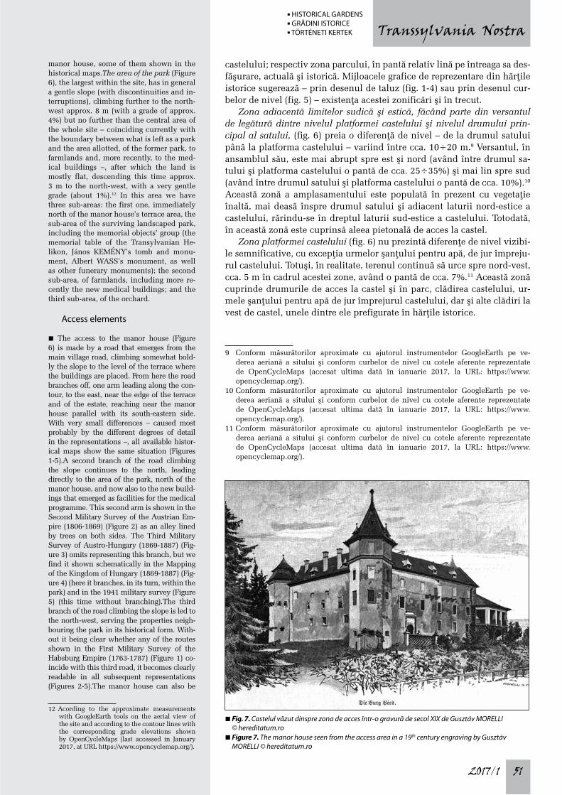
n Fig. 7. Castelul văzut dinspre zona de acces într-o gravură de secol XIX de Gusztáv MORELLI © hereditatum.ro
n Figure 7. The manor house seen from the access area in a 19th century engraving by Gusztáv MORELLI © hereditatum.ro
n HISTORICAL GARDENS n GRĂDINI ISTORICE n TÖRTÉNETI KERTEK
2017/152
Transsylvania Nostra
Zona parcului (fig. 6), cea mai amplă în cadrul amplasamentului, pre-zintă în general o pantă lină (cu discontinuităþi şi inconsecvenþe), urcând în continuare spre nord-vest, cca. 8 m (cu o pantă de cca. 4%) dar nu mai departe de partea centrală a întregului amplasament – coincizând la ora actuală cu limita dintre ceea ce a mai rămas ca amenajare de parc şi suprafaþa alocată, din fostul parc, terenurilor agricole şi, mai recent, pa-vilioanelor medicale –, după care terenul este aproximativ plat, coborând de data aceasta c. 3 m înspre nord-vest cu o pantă foarte lină (c. 1%).12 În această zonă avem trei subzone: cea dintâi, imediat la nord de zona platformei castelului, subzona amenajărilor supravieþuitoare ale parcului peisager, cuprinzând şi grupul obiectelor memoriale (masa memorială a Helikon-ului Ardelean, mormântul şi monumentul lui János KEMÉNY, monumentul lui Albert WASS precum şi alte monumente funerare); cea de-a doua, subzona devenită a terenurilor agricole incluzând, mai recent, noile construcþii pentru programul medical; şi cea de-a treia, subzona livezii.
12 Conform măsurătorilor aproximate cu ajutorul instrumentelor GoogleEarth pe vederea aeriană a sitului şi conform curbelor de nivel cu cotele aferente reprezentate de OpenCycleMaps (accesat ultima dată în ianuarie 2017, la URL: https://www.opencyclemap.org/).
reached by a winding walkway (Figure 6) near and east of the road climbing abruptly the slope between the main village road and the manor house’s terrace. The walkway meets the road branch led along the south-eastern side of the manor house near its southern tower. The presence of the walkway is not documented in any of the historical maps, which may be due either to its absence or to the minor character of the elements implied by such a connection. Also, further east of the winding walkway there is a stepped alley,13 climbing in a straight line the slope near the main village road up to the southern tower.The main entrance to the manor house build-ing is made on its south-eastern side, cross-ing the traces of the moat on a small bridge (Photos 5 and 7). The gangway-like space of the entrance leads subsequently to the man-or house’s inner courtyard. The entrance to
13 This alley is also graphically documented in a 19th century representation of the manor house created by Károly SZATHMÁRI PAP (2012, 185).
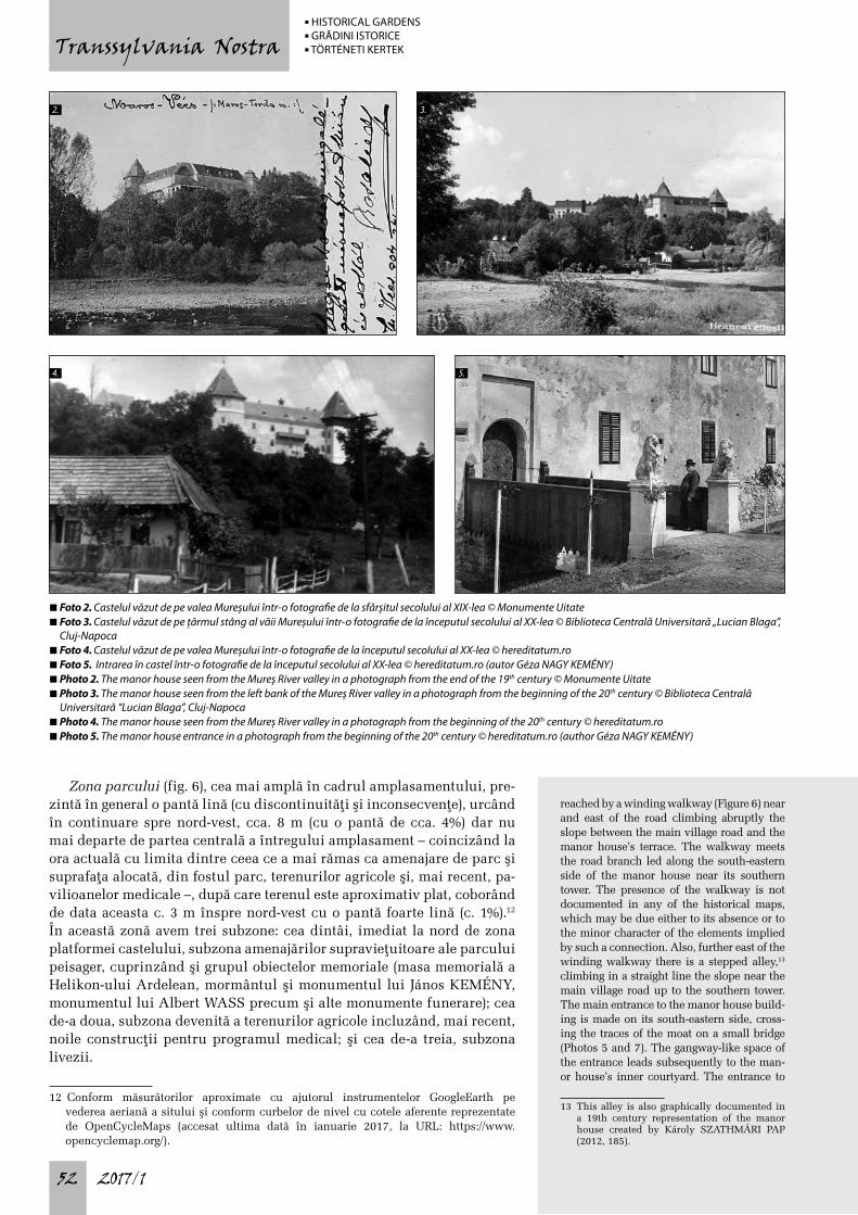
n Foto 2. Castelul văzut de pe valea Mureșului într-o fotografie de la sfârșitul secolului al XIX-lea © Monumente Uitaten Foto 3. Castelul văzut de pe țărmul stâng al văii Mureșului într-o fotografie de la începutul secolului al XX-lea © Biblioteca Centrală Universitară „Lucian Blaga”,
Cluj-Napocan Foto 4. Castelul văzut de pe valea Mureșului într-o fotografie de la începutul secolului al XX-lea © hereditatum.ro n Foto 5. Intrarea în castel într-o fotografie de la începutul secolului al XX-lea © hereditatum.ro (autor Géza NAGY KEMÉNY) n Photo 2. The manor house seen from the Mureș River valley in a photograph from the end of the 19th century © Monumente Uitaten Photo 3. The manor house seen from the left bank of the Mureș River valley in a photograph from the beginning of the 20th century © Biblioteca Centrală
Universitară “Lucian Blaga”, Cluj-Napocan Photo 4. The manor house seen from the Mureș River valley in a photograph from the beginning of the 20th century © hereditatum.ro n Photo 5. The manor house entrance in a photograph from the beginning of the 20th century © hereditatum.ro (author Géza NAGY KEMÉNY)
2.
4.
3.
5.
n HISTORICAL GARDENS n GRĂDINI ISTORICE n TÖRTÉNETI KERTEK
2017/1 53
Transsylvania Nostra
Amenajările de acces
n Accesul la castel (fig. 6) este asigurat de un drum care se desprinde din drumul principal al satului, urcând oarecum pieptiş versantul până la ni-velul platformei pe care sunt situate construcþiile. De aici drumul se rami-fică, unul din braþe fiind condus de-a lungul curbei de nivel, spre est, în apropierea marginii platformei şi a limitei proprietăþii, ajungând în drep-tul castelului în paralel cu latura sud-estică a acestuia. Cu foarte mici di-ferenþe – datorate, probabil, mai degrabă gradului diferit de detaliere a reprezentări lor –, toate hărþile istorice de care dispunem prezintă aceeaşi situaþie (fig. 1-5).
Un al doilea braþ al ramificaþiei drumului care urcă versantul continuă spre nord, conducând direct în zona parcului, desfăşurat la nord de castel, şi totodată, în prezent, la noile construcþii apărute ca dotări ale programului medical. Acest al doilea braþ este prefigurat în cea de-a doua ridicare topo-grafică militară a Imperiului Austriac (1806-1869) (fig. 2) sub forma unei alei aliniate cu arbori pe ambele laturi. Cea de-a treia ridicare topografică militară a Austro-Ungariei (1869-1887) (fig. 3) omite reprezentarea acestui braþ, dar îl regăsim reprezentat schematic în cartarea Regatului Maghiar (1869-1887) (fig. 4) (aici el se ramifică, la rândul lui, în cadrul parcului) şi în harta militară din 1941 (fig. 5) (de data aceasta fără ramificaþie).
Al treilea braþ al ramificaþiei drumului care urcă versantul este con-dus spre nord-vest, deservind proprietăþile învecinate parcului în forma sa istorică. Fără a fi clar dacă vreunul din traseele reprezentate în prima ridicare topografică militară a Imperiului Habsburgic (1763-1787) (fig. 1) ar coincide cu acest al treilea braþ de drum, el devine clar lizibil în toate reprezentările ulterioare (fig. 2-5).
La castel se mai poate ajunge şi prin intermediul unei alei pietonale, con-duse în zigzag (fig. 6) în apropiere şi la est de drumul care urcă pieptiş versan-tul între drumul principal al satului şi platforma castelului. Aleea pietonală întâlneşte braþul de drum condus de-a lungul laturii sud-estice a castelului în apropierea turnului sudic al acestuia. Prezenþa aleii pietonale nu apare documentată în reprezentările hărþilor istorice, fapt care se poate datora fie absenþei sale, fie caracterului minor al amenajărilor pe care o astfel de legătu-ră le presupune. De asemenea, şi mai la est de aleea pietonală în zigzag se află o alee în trepte,13 urcând în linie dreaptă versantul din apropierea drumului principal al satului până în dreptul turnului sudic.
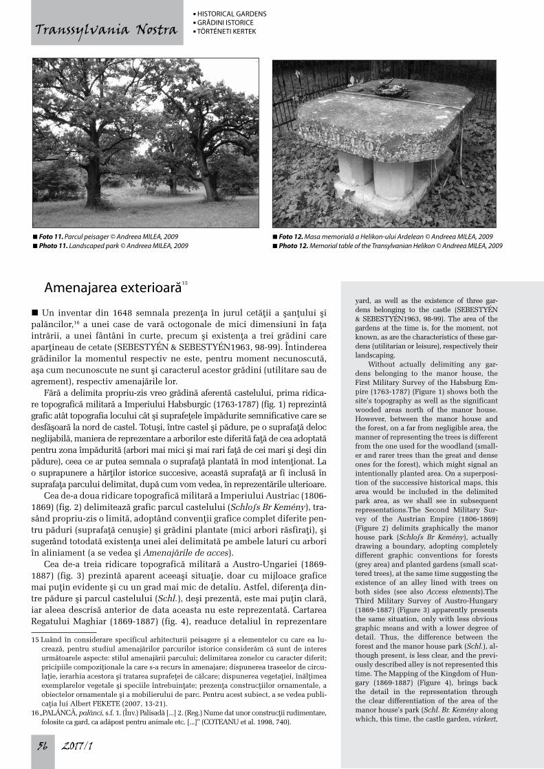
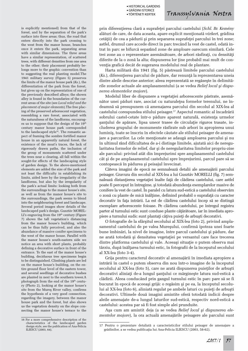
Accesul principal în clădirea castelului se face pe latura sud-estică a acestuia, traversând pe un mic pod urmele şanþului pentru apă (foto 5, 7). Spaþiul de tip gang al intrării conduce ulterior în curtea interioară a caste-lului. Accesul în spaþiile castelului este posibil şi din gangul turnului estic şi de pe latura nord-vestică a castelului (urcând din fostul şanþ pentru apă, prin intermediul unei scări, până în dreptul primului nivel al clădirii) (foto 10).
Amenajările de acces trebuie să fi avut la origine un grad mic de elabo-rare dat fiind caracterul mai degrabă neprimitor al construcþiei. Reprezen-tări şi ilustrate de la sfârşitul secolului al XIX-lea şi începutul secolului al XX-lea ne prezintă o zonă a intrării principale în castel în care se simte, to-tuşi, un oarecare grad de decorativism: vegetaþie măruntă de-a lungul laturii sud-estice a castelului, plante agăþătoare pe pereþii castelului de jur împre-jurul gangului de la parterul turnului estic, stâlpii de capăt ai parapetelor podului prevăzuþi cu sfere decorative şi, ulterior, cu lei sculptaþi. La ora actuală plantele agăþătoare au dispărut de pe pereþii castelului iar podul şi-a pierdut elementele decorative; o vegetaþie măruntă decorativă este, în conti-nuare, întreþinută de-a lungul aleii paralele cu latura sud-estică a castelului.
13 Această alee este documentată grafic şi într-o reprezentare de secol XIX a castelului executată de SZATHMÁRI PAP Károly (2012, 185).
the manor house’s spaces can also be made from the east tower’s gangway and on the manor house’s north-western side (climbing from the former moat, through a stairway, to the building’s first level) (Photo 10).The ac-cess elements must have not been originally very developed, given the rather unwelcom-ing character of the building. Drawings and postcards from the end of the 19th and the beginning of the 20th century show us a main entrance area in which one can feel, however, a certain degree of decoration: the short vege-tation along the manor house’s south-eastern side, climbing plants on the manor house walls all around the gangway on the east tow-er’s ground floor, the pillars at the end of the bridge’s parapets having decorative spheres and, subsequently, sculpted lions. Nowadays, the climbing plants have disappeared from the manor house walls and the bridge lost its decorative elements; short decorative vegeta-tion is still maintained along the alley parallel to the south-eastern side of the manor house.
The manor house and its relation-ship with the landscape design
n The manor house in Brâncoveneşti has few intentions of opening on the landscape; it is a former fortified manor house, which has preserved to a large extent the image of a defensive architecture, determining József BIRÓ to describe it as “the most sober and sombre of all Transylvanian manor houses”.14 Even the main access to the manor house has preserved its historical character, being preceded by a small bridge crossing the for-mer moat, initially a drawbridge, which upon closing was a perfect fit to the casing drawn on the south-eastern elevation by the portal’s frame (WEISZ 2007, 98).All available histori-cal maps before the 20th century (Figures 1-4) show the manor house as a rectangular build-ing, with a square inner courtyard and prom-
14 See note 8, above.
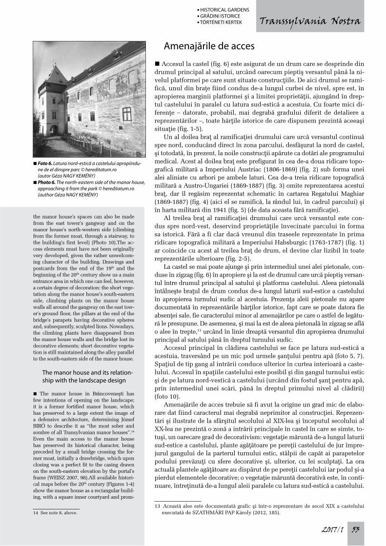
n Foto 6. Latura nord-estică a castelului apropiindu-ne de el dinspre parc © hereditatum.ro (autor Géza NAGY KEMÉNY)
n Photo 6. The north-eastern side of the manor house, approaching it from the park © hereditatum.ro (author Géza NAGY KEMÉNY)
n HISTORICAL GARDENS n GRĂDINI ISTORICE n TÖRTÉNETI KERTEK
2017/154
Transsylvania Nostra
Castelul şi relaţia lui cu amenajările exterioare
n Castelul din Brâncoveneşti prezintă puþine intenþii de deschidere către amenajările exterioare; este un fost castel-cetate, care a păstrat în mare parte imaginea unei arhitecturi defensive, determinându-l pe József BIRÓ să îl caracterizeze drept „cel mai sobru şi mai sumbru dintre toate castelele ardelene”.14 Până şi accesul principal în castel şi-a păstrat caracterul isto-ric, fiind precedat de un mic pod traversând fostul şanþ cu apă, pod iniþial mobil, care la închidere se potrivea perfect în chenarul delimitat pe pere-tele faþadei sud-estice de ancadramentul portalului (WEISZ 2007, 98).Toate hărþile istorice premergătoare secolului al XX-lea de care dispunem (fig. 1-4) înfăþişează castelul sub forma unei construcþii rectangulare, cu curte interioară pătrată şi colþurile exterioare proeminente, cel puþin planime-tric dacă nu şi volumetric. Harta militară din 1941 omite reprezentarea castelului, a cărui prezenþă o semnalează prin însemnarea „Ks.” (probabil prescurtarea cuvântului kastély, adică castel în limba maghiară) (fig. 5).
În prezent, castelul este, în continuare, o clădire rectangulară cu patru turnuri proeminente de colþ, înălþându-se deasupra terenului pe trei nive-luri pentru cele patru aripi ale sale, respectiv pe patru niveluri pentru tur-nurile de colþ. Dacă pentru cele două turnuri mai mici, cel nordic şi cel ves-tic, cel de-al patrulea nivel este unul orb (fără ferestre), turnurile mai mari, cel sudic şi cel estic, dispun de deschideri şi spaþii locuibile pe toate cele patru niveluri ale lor, turnul estic cu deschidere chiar pe întregul perimetru.
Ferestrele castelului sunt mici, de tip „gol împuşcat”, nu foarte nume-roase. Urmărind materialul iconografic disponibil (gravuri, dar şi ilustrate şi fotografii de la sfârşitul secolului al XIX-lea şi începutul secolului al XX-lea, fig. 7, foto 2-4, 6), putem observa modificări survenite în numărul şi distribuþia golurilor, unele dintre ele alternând între a fi reprezentate ca goluri cu ferestre sau goluri oarbe (închise).
Refacerile acoperişurilor, chiar dacă au produs modificări ale volume-triei acestora, nu au adus schimbări semnificative privind relaþionarea cu exteriorul; micile lucarne prezente în unele dintre imagini nu puteau ser-vi decât la aerisirea podurilor.
14 Vezi nota 8, mai sus.
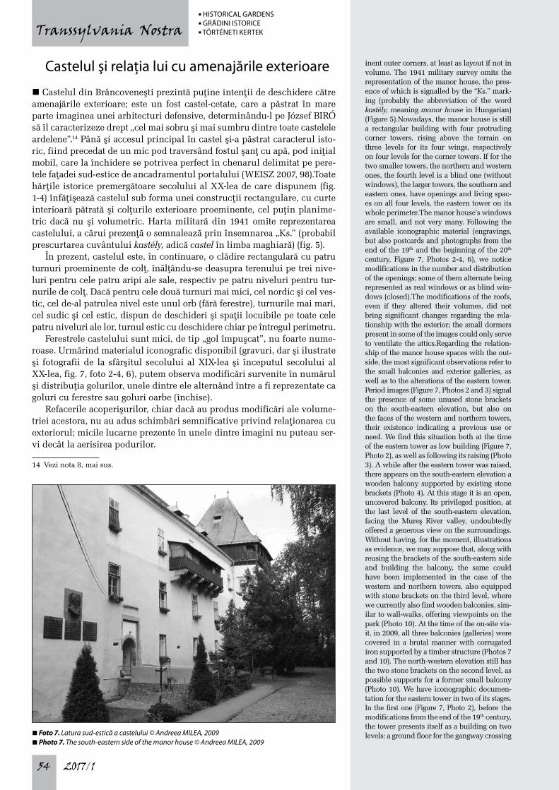
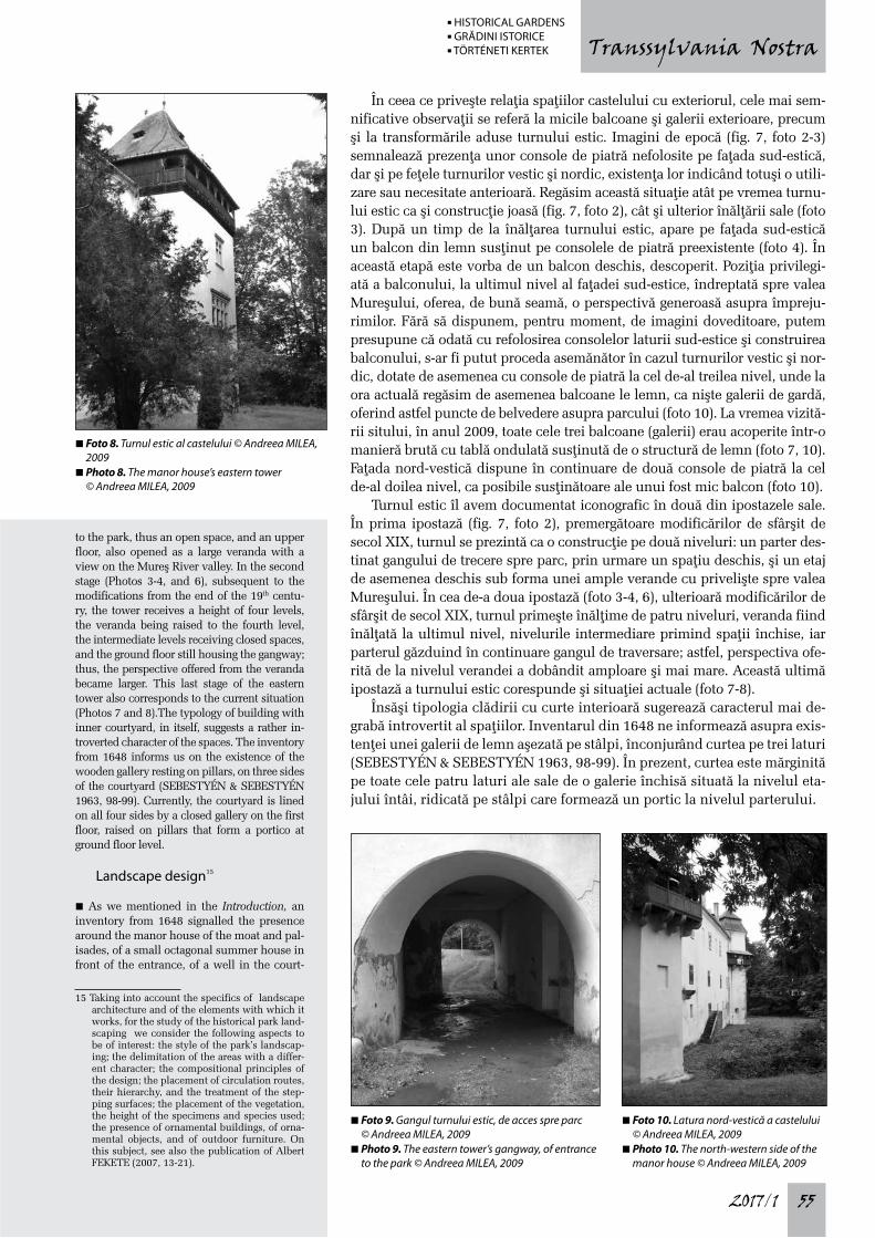
inent outer corners, at least as layout if not in volume. The 1941 military survey omits the representation of the manor house, the pres-ence of which is signalled by the “Ks.” mark-ing (probably the abbreviation of the word kastély, meaning manor house in Hungarian) (Figure 5).Nowadays, the manor house is still a rectangular building with four protruding corner towers, rising above the terrain on three levels for its four wings, respectively on four levels for the corner towers. If for the two smaller towers, the northern and western ones, the fourth level is a blind one (without windows), the larger towers, the southern and eastern ones, have openings and living spac-es on all four levels, the eastern tower on its whole perimeter.The manor house’s windows are small, and not very many. Following the available iconographic material (engravings, but also postcards and photographs from the end of the 19th and the beginning of the 20th century, Figure 7, Photos 2-4, 6), we notice modifications in the number and distribution of the openings; some of them alternate being represented as real windows or as blind win-dows (closed).The modifications of the roofs, even if they altered their volumes, did not bring significant changes regarding the rela-tionship with the exterior; the small dormers present in some of the images could only serve to ventilate the attics.Regarding the relation-ship of the manor house spaces with the out-side, the most significant observations refer to the small balconies and exterior galleries, as well as to the alterations of the eastern tower. Period images (Figure 7, Photos 2 and 3) signal the presence of some unused stone brackets on the south-eastern elevation, but also on the faces of the western and northern towers, their existence indicating a previous use or need. We find this situation both at the time of the eastern tower as low building (Figure 7, Photo 2), as well as following its raising (Photo 3). A while after the eastern tower was raised, there appears on the south-eastern elevation a wooden balcony supported by existing stone brackets (Photo 4). At this stage it is an open, uncovered balcony. Its privileged position, at the last level of the south-eastern elevation, facing the Mureş River valley, undoubtedly offered a generous view on the surroundings. Without having, for the moment, illustrations as evidence, we may suppose that, along with reusing the brackets of the south-eastern side and building the balcony, the same could have been implemented in the case of the western and northern towers, also equipped with stone brackets on the third level, where we currently also find wooden balconies, sim-ilar to wall-walks, offering viewpoints on the park (Photo 10). At the time of the on-site vis-it, in 2009, all three balconies (galleries) were covered in a brutal manner with corrugated iron supported by a timber structure (Photos 7 and 10). The north-western elevation still has the two stone brackets on the second level, as possible supports for a former small balcony (Photo 10). We have iconographic documen-tation for the eastern tower in two of its stages. In the first one (Figure 7, Photo 2), before the modifications from the end of the 19th century, the tower presents itself as a building on two levels: a ground floor for the gangway crossing n Foto 7. Latura sud-estică a castelului © Andreea MILEA, 2009
n Photo 7. The south-eastern side of the manor house © Andreea MILEA, 2009
n HISTORICAL GARDENS n GRĂDINI ISTORICE n TÖRTÉNETI KERTEK
2017/1 55
Transsylvania Nostra
În ceea ce priveşte relaþia spaþiilor castelului cu exteriorul, cele mai sem-nificative observaþii se referă la micile balcoane şi galerii exterioare, precum şi la transformările aduse turnului estic. Imagini de epocă (fig. 7, foto 2-3) semnalează prezenþa unor console de piatră nefolosite pe faþada sud-estică, dar şi pe feþele turnurilor vestic şi nordic, existenþa lor indicând totuşi o utili-zare sau necesitate anterioară. Regăsim această situaþie atât pe vremea turnu-lui estic ca şi construcþie joasă (fig. 7, foto 2), cât şi ulterior înălþării sale (foto 3). După un timp de la înălþarea turnului estic, apare pe faþada sud-estică un balcon din lemn susþinut pe consolele de piatră preexistente (foto 4). În această etapă este vorba de un balcon deschis, descoperit. Poziþia privilegi-ată a balconului, la ultimul nivel al faþadei sud-estice, îndreptată spre valea Mureşului, oferea, de bună seamă, o perspectivă generoasă asupra împreju-rimilor. Fără să dispunem, pentru moment, de imagini doveditoare, putem presupune că odată cu refolosirea consolelor laturii sud-estice şi construirea balconului, s-ar fi putut proceda asemănător în cazul turnurilor vestic şi nor-dic, dotate de asemenea cu console de piatră la cel de-al treilea nivel, unde la ora actuală regăsim de asemenea balcoane le lemn, ca nişte galerii de gardă, oferind astfel puncte de belvedere asupra parcului (foto 10). La vremea vizită-rii sitului, în anul 2009, toate cele trei balcoane (galerii) erau acoperite într-o manieră brută cu tablă ondulată susþinută de o structură de lemn (foto 7, 10). Faþada nord-vestică dispune în continuare de două console de piatră la cel de-al doilea nivel, ca posibile susþinătoare ale unui fost mic balcon (foto 10).
Turnul estic îl avem documentat iconografic în două din ipostazele sale. În prima ipostază (fig. 7, foto 2), premergătoare modificărilor de sfârşit de secol XIX, turnul se prezintă ca o construcþie pe două niveluri: un parter des-tinat gangului de trecere spre parc, prin urmare un spaþiu deschis, şi un etaj de asemenea deschis sub forma unei ample verande cu privelişte spre valea Mureşului. În cea de-a doua ipostază (foto 3-4, 6), ulterioară modificărilor de sfârşit de secol XIX, turnul primeşte înălþime de patru niveluri, veranda fiind înălþată la ultimul nivel, nivelurile intermediare primind spaþii închise, iar parterul găzduind în continuare gangul de traversare; astfel, perspectiva ofe-rită de la nivelul verandei a dobândit amploare şi mai mare. Această ultimă ipostază a turnului estic corespunde şi situaþiei actuale (foto 7-8).
Însăşi tipologia clădirii cu curte interioară sugerează caracterul mai de-grabă introvertit al spaþiilor. Inventarul din 1648 ne informează asupra exis-tenþei unei galerii de lemn aşezată pe stâlpi, înconjurând curtea pe trei laturi (SEBESTYÉN & SEBESTYÉN 1963, 98-99). În prezent, curtea este mărginită pe toate cele patru laturi ale sale de o galerie închisă situată la nivelul eta-jului întâi, ridicată pe stâlpi care formează un portic la nivelul parterului.
to the park, thus an open space, and an upper floor, also opened as a large veranda with a view on the Mureş River valley. In the second stage (Photos 3-4, and 6), subsequent to the modifications from the end of the 19th centu-ry, the tower receives a height of four levels, the veranda being raised to the fourth level, the intermediate levels receiving closed spaces, and the ground floor still housing the gangway; thus, the perspective offered from the veranda became larger. This last stage of the eastern tower also corresponds to the current situation (Photos 7 and 8).The typology of building with inner courtyard, in itself, suggests a rather in-troverted character of the spaces. The inventory from 1648 informs us on the existence of the wooden gallery resting on pillars, on three sides of the courtyard (SEBESTYÉN & SEBESTYÉN 1963, 98-99). Currently, the courtyard is lined on all four sides by a closed gallery on the first floor, raised on pillars that form a portico at ground floor level.
Landscape design15
n As we mentioned in the Introduction, an inventory from 1648 signalled the presence around the manor house of the moat and pal-isades, of a small octagonal summer house in front of the entrance, of a well in the court-
15 Taking into account the specifics of landscape architecture and of the elements with which it works, for the study of the historical park land-scaping we consider the following aspects to be of interest: the style of the park’s landscap-ing; the delimitation of the areas with a differ-ent character; the compositional principles of the design; the placement of circulation routes, their hierarchy, and the treatment of the step-ping surfaces; the placement of the vegetation, the height of the specimens and species used; the presence of ornamental buildings, of orna-mental objects, and of outdoor furniture. On this subject, see also the publication of Albert FEKETE (2007, 13-21).
n Foto 8. Turnul estic al castelului © Andreea MILEA, 2009
n Photo 8. The manor house’s eastern tower © Andreea MILEA, 2009
n Foto 9. Gangul turnului estic, de acces spre parc © Andreea MILEA, 2009
n Photo 9. The eastern tower’s gangway, of entrance to the park © Andreea MILEA, 2009
n Foto 10. Latura nord-vestică a castelului © Andreea MILEA, 2009
n Photo 10. The north-western side of the manor house © Andreea MILEA, 2009
n HISTORICAL GARDENS n GRĂDINI ISTORICE n TÖRTÉNETI KERTEK
2017/156
Transsylvania Nostra
Amenajarea exterioară15
n Un inventar din 1648 semnala prezenþa în jurul cetăþii a şanþului şi palăncilor,16 a unei case de vară octogonale de mici dimensiuni în faþa intrării, a unei fântâni în curte, precum şi existenþa a trei grădini care aparþineau de cetate (SEBESTYÉN & SEBESTYÉN1963, 98-99). Întinderea grădinilor la momentul respectiv ne este, pentru moment necunoscută, aşa cum necunoscute ne sunt şi caracterul acestor grădini (utilitare sau de agrement), respectiv amenajările lor.
Fără a delimita propriu-zis vreo grădină aferentă castelului, prima ridica-re topografică militară a Imperiului Habsburgic (1763-1787) (fig. 1) reprezintă grafic atât topografia locului cât şi suprafeþele împădurite semnificative care se desfăşoară la nord de castel. Totuşi, între castel şi pădure, pe o suprafaþă deloc neglijabilă, maniera de reprezentare a arborilor este diferită faþă de cea adoptată pentru zona împădurită (arbori mai mici şi mai rari faþă de cei mari şi deşi din pădure), ceea ce ar putea semnala o suprafaþă plantată în mod intenþionat. La o suprapunere a hărþilor istorice succesive, această suprafaþă ar fi inclusă în suprafaþa parcului delimitat, după cum vom vedea, în reprezentările ulterioare.
Cea de-a doua ridicare topografică militară a Imperiului Austriac (1806-1869) (fig. 2) delimitează grafic parcul castelului (Schlo s Br Kemény), tra-sând propriu-zis o limită, adoptând convenþii grafice complet diferite pen-tru păduri (suprafaþă cenuşie) şi grădini plantate (mici arbori răsfiraþi), şi sugerând totodată existenþa unei alei delimitată pe ambele laturi cu arbori în aliniament (a se vedea şi Amenajările de acces).
Cea de-a treia ridicare topografică militară a Austro-Ungariei (1869-1887) (fig. 3) prezintă aparent aceeaşi situaþie, doar cu mijloace grafice mai puþin evidente şi cu un grad mai mic de detaliu. Astfel, diferenþa din-tre pădure şi parcul castelului (Schl.), deşi prezentă, este mai puþin clară, iar aleea descrisă anterior de data aceasta nu este reprezentată. Cartarea Regatului Maghiar (1869-1887) (fig. 4), readuce detaliul în reprezentare
15 Luând în considerare specificul arhitecturii peisagere şi a elementelor cu care ea lu-crează, pentru studiul amenajărilor parcurilor istorice considerăm că sunt de interes următoarele aspecte: stilul amenajării parcului; delimitarea zonelor cu caracter diferit; pricipiile compoziþionale la care s-a recurs în amenajare; dispunerea traseelor de circu-laþie, ierarhia acestora şi tratarea suprafeþei de călcare; dispunerea vegetaþiei, înălþimea exemplarelor vegetale şi speciile întrebuinþate; prezenþa construcþiilor ornamentale, a obiectelor ornamentale şi a mobilierului de parc. Pentru acest subiect, a se vedea publi-caþia lui Albert FEKETE (2007, 13-21).
16 „PALÁNCĂ, palănci, s.f. 1. (Înv.) Palisadă [...] 2. (Reg.) Nume dat unor construcþii rudimentare, folosite ca gard, ca adăpost pentru animale etc. [...]” (COTEANU et al. 1998, 740).
yard, as well as the existence of three gar-dens belonging to the castle (SEBESTYÉN & SEBESTYÉN1963, 98-99). The area of the gardens at the time is, for the moment, not known, as are the characteristics of these gar-dens (utilitarian or leisure), respectively their landscaping.
Without actually delimiting any gar-dens belonging to the manor house, the First Military Survey of the Habsburg Em-pire (1763-1787) (Figure 1) shows both the site’s topography as well as the significant wooded areas north of the manor house. However, between the manor house and the forest, on a far from negligible area, the manner of representing the trees is different from the one used for the woodland (small-er and rarer trees than the great and dense ones for the forest), which might signal an intentionally planted area. On a superposi-tion of the successive historical maps, this area would be included in the delimited park area, as we shall see in subsequent representations.The Second Military Sur-vey of the Austrian Empire (1806-1869) (Figure 2) delimits graphically the manor house park (Schlo s Br Kemény), actually drawing a boundary, adopting completely different graphic conventions for forests (grey area) and planted gardens (small scat-tered trees), at the same time suggesting the existence of an alley lined with trees on both sides (see also Access elements).The Third Military Survey of Austro-Hungary (1869-1887) (Figure 3) apparently presents the same situation, only with less obvious graphic means and with a lower degree of detail. Thus, the difference between the forest and the manor house park (Schl.), al-though present, is less clear, and the previ-ously described alley is not represented this time. The Mapping of the Kingdom of Hun-gary (1869-1887) (Figure 4), brings back the detail in the representation through the clear differentiation of the area of the manor house’s park (Schl. Br. Kemény along which, this time, the castle garden, várkert,
n Foto 11. Parcul peisager © Andreea MILEA, 2009n Photo 11. Landscaped park © Andreea MILEA, 2009
n Foto 12. Masa memorială a Helikon-ului Ardelean © Andreea MILEA, 2009n Photo 12. Memorial table of the Transylvanian Helikon © Andreea MILEA, 2009
n HISTORICAL GARDENS n GRĂDINI ISTORICE n TÖRTÉNETI KERTEK
2017/1 57
Transsylvania Nostra
prin diferenþierea clară a suprafeþei parcului castelului (Schl. Br. Kemény alături de care, de data aceasta, apare explicit menþionată várkert, grădina cetăþii) de cea a pădurii şi prin separarea suprafeþei parcului în trei zone; astfel, drumul care accede direct în parc trecând la vest de castel, odată in-trat în parc se bifurcă separând zone de amploare oarecum similară. Cele trei zone au o reprezentare asemănătoare, de arbori răsfiraþi, cu densităþi diferite de la o zonă la alta; dispunerea lor þine probabil mai mult de con-venþia grafică decât de sugerarea modelului real de plantare.
Harta militară din 1941 (fig. 5) păstrează limitele parcului castelului (Ks.), diferenþierea parcului de pădure, dar renunþă la reprezentarea uneia dintre aleile descrise anterior; aleea reprezentată se regăseşte în delimită-rile zonelor actuale ale amplasamentului (a se vedea Relief local şi dispu-nerea elementelor majore).
Modelul liber de dispunere a vegetaþiei arborescente păstrate, asemă-nător unei păduri rare, asociat cu naturaleþea formelor terenului, ne în-deamnă să presupunem că amenajarea parcului din secolul al XIX-lea al castelului corespundea stilului peisager.17 Aspectul romantic al încadrării sobrului castel-cetate într-o pădure aparent naturală, existenþa urmelor şanþului de apărare, lipsa uneor trasee de circulaþie riguros trasate, in-cluderea grupului de monumente răsfirate sub arbori în apropierea unui luminiş, toate se înscriu în efectele căutate ale stilului peisager de amena-jare a parcurilor. La cele menþionate se adaugă amploarea parcului şi nu în ultimul rând dificultatea de a-i distinge limitele, ajutată aici de neregu-laritatea formelor de relief, dar şi de neregularitatea limitelor propriu-zise ale parcului: privind atât din împrejurimi spre amplasamentul castelului cât şi de pe amplasamentul castelului spre împrejurimi, parcul pare să se contopească în pădurea şi peisajul învecinat.
Câteva imagini de epocă ne semnalează detalii ale amenajării parcului peisager. Gravura din secolul al XIX-lea a lui Gusztáv MORELLI (fig. 7) sem-nalează distanþierea vegetaþiei înalte faþă de clădirea castelului, care astfel poate fi perceput în întregime, şi totodată abundenþa exemplarelor masive de conifere la vest de castel. În paralel cu latura sud-estică a castelului observăm o zonă cu plante de mică înălþime, definind probabil o suprafaþă cu caracter decorativ în faþa intrării. La est de clădirea castelului încep să se distingă exemplare arborescente foioase. Pe clădirea castelului, pe întregul registru parter al turnului estic sunt conduse plante căþărătoare, iar în imediata apro-piere a turnului sudic sunt plantaþi câþiva puieþi de arbuşti decorativi.
O fotografie de la sfârşitul secolului al XIX-lea (foto 2), privind ampla-samentul castelului de pe valea Mureşului, confirmă ipoteza unei foarte bune îmbinări, la nivel de imagine, între parcul castelului şi pădure, dar ne arată totodată şi densitatea vegetaþiei pe versantul care face trecerea dintre platforma castelului şi vale. Aceeaşi situaþie o putem observa mai târziu, după înălþarea turnului estic, în fotografii de la începutul secolului al XX-lea (foto 3-4).
Grija pentru caracterul decorativ al amenajării în imediata apropiere a intrării în castel o putem observa din nou într-o imagine de la începutul secolului al XX-lea (foto 5), care ne arată dispunerea puieþilor de arbuşti decorativi aliniaþi de-a lungul şanþului ce mărgineşte latura sud-estică a clădirii. Aleea conducând prin gangul turnului estic în parc pare să se fi bucurat în epocă de aceeaşi grijă: o regăsim şi pe ea, la începutul secolu-lui al XX-lea (foto 6), aliniată regulat pe ambele laturi cu puieþi de arbuşti decorativi. Ultimele două imagini amintite oferă totodată indicii despre aleile amenajate de-a lungul laturilor sud-estică, respectiv nord-estică a castelului: acestea par să fi fost simple alei prunduite.
Aşa cum am amintit deja (a se vedea Relief local şi dispunerea ele-mentelor majore), la ora actuală amenajările peisagere ale parcului sunt
17 Pentru o prezentare detaliată a caracteristicilor stilului peisager de amenajare a grădinilor, a se vedea publicaþia lui Ana-Felicia ILIESCU (2003, 58-62).
is explicitly mentioned) from that of the forest, and by the separation of the park’s surface into three areas; thus, the road that enters directly into the park crossing to the west from the manor house, branches once it enters the park, separating areas with similar dimensions. The three areas have a similar representation, of scattered trees, with different densities from one area to the other; their placement probably be-longs more to the graphic convention than to suggesting the real planting model.The 1941 military survey (Figure 5) preserves the limits of the manor house park (Ks.), the differentiation of the park from the forest, but gives up on the representation of one of the previously described alleys; the shown alley is found in the boundaries of the cur-rent areas of the site (see Local relief and the placement of major elements).The free plac-ing of the preserved arborescent vegetation, resembling a rare forest, associated with the naturalness of the landforms, encourag-es us to suppose that the design of the 19th century manor house park corresponded to the landscaped style16. The romantic as-pect of framing the sombre fortified manor house in an apparently natural forest, the existence of the moat’s traces, the lack of rigorously drawn paths, the inclusion of the group of monuments scattered under the trees near a clearing, all fall within the sought-for effects of the landscaping style of garden design. To the above-mentioned elements are added the size of the park and not least the difficulty in establishing its limits, aided here by the irregularity of the landforms, but also by the irregularity of the park’s actual limits: looking both from the surroundings to the manor house’s site, as well as from the manor house’s site to the surroundings, the park seems to blend into the neighbouring forest and landscape.Several period images show details of the landscaped park’s design. Gusztáv MOREL-LI’s engraving from the 19th century (Figure 7) shows the tall vegetation’s distancing from the manor house’s building, which can be thus fully perceived, and also the abundance of massive conifer specimens to the west of the manor house. Parallel with the manor house’s south-eastern side we notice an area with short plants, probably defining a decorative surface in front of the entrance. To the east of the manor house’s building, deciduous tree specimens begin to be distinguished. Climbing plants are led on the manor house’s building, on the en-tire ground floor level of the eastern tower, and several seedlings of decorative bushes are planted in next to the southern tower.A photograph from the end of the 19th centu-ry (Photo 2), looking at the manor house’s site from the Mureş River valley, confirms the hypothesis of a very good connection, regarding the imagery, between the manor house park and the forest, but also shows us the vegetation density on the slope con-necting the manor house’s terrace to the
16 For a more comprehensive description of the characteristics of the landscaped garden design style, see the publication of Ana-Felicia ILIESCU (2003, 64).
n HISTORICAL GARDENS n GRĂDINI ISTORICE n TÖRTÉNETI KERTEK
2017/158
Transsylvania Nostra
restrânse pe o suprafaþă considerabil mai mică decât cea iniþială, grupată în jurul castelului, îndeosebi înspre sud, est, respectiv nord. Dispunerea vegetaþiei mature pe teren şi-a păstrat naturaleþea (foto 11), dar unele deta-lii şi-au pierdut din rafinament: aleile amintite anterior fie au fost asfaltate (foto 7), fie şi-au pierdut suprafaþa prunduită, devenind simple alei de pă-mânt (foto 9); caracterul ornamental al vegetaþiei în dreptul faþadei sud-es-tice a intrării a devenit mai puþin coerent, amestecând diverse specii, fără o regulă anume; iar monumentele din parc au pierdut din romantismul imaginii prin apariþia unor împrejmuiri de protecþie (foto 12-14).
Concluzie
n Datorită, în bună măsură, folosirii sale continue, castelul Kendi-Kemény din Brâncoveneşti se află într-o stare bună, chiar dacă unele modificări i-au fost aduse şi, prin aceasta, unele valori s-au pierdut (s-au pierdut detalii pre-cum leii sculptaþi aşezaþi pe vremuri de o parte şi de alta a intrării pe pod, po-dul însuşi a suferit modificări, balcoanele-galerie au fost alterate prin adăuga-rea unor structuri de acoperire, mormintele şi masa memorială a Helikon-ului Ardelean au primit îngrădiri de protecþie etc.). Suprafaþa parcului, rămânând vizibile delimitările istorice, se prezintă la ora actuală sub forma unor zone cu caracter extrem de diferit. O zonă păstrată ca parc de agrement cu carac-ter peisager; o a doua zonă cu terenuri agricole şi inserþii construite recent preluând programul medical mutat din castel; şi o a treia zonă, de asemenea cu caracter utilitar, sub forma unei livezi. Probabilitatea păstrării funcþiuni-lor utilitare pe sit este mare, cel puþin pentru perioada imediat următoare. Păstrarea programului medical pe sit are avantajele şi dezavantajele sale în relaþie cu ansamblul istoric. Dezavantajul constă în ocuparea suprafeþei fos-tului parc cu noi construcþii, modificând caracterul locului. Avantajul constă în necesitatea creării de amenajări exterioare, benefice pentru pacienþi, pe care un astfel de program o presupune, dând astfel ocazia reluării funcþiunii de destindere cu amenajări corespunzătoare pentru o parte din suprafeþele ocupate la ora actuală de terenuri agricole sau livezi. Totuşi, chiar luând în considerare acest posibil avantaj, în lipsa unor documente tehnice (planuri ale amenajării istorice) şi ale urmelor fostelor amenajări pe sit, decizia unor amenajări inovatoare va avea de confruntat dificultatea alegerilor concrete în proiectare pentru a răspunde statutului actual al sitului, de ansamblu mo-nument istoric, din care face parte un parc clasat drept monument istoric. În ceea ce priveşte zona păstrată la ora actuală ca parc de agrement, principala
valley. The same situation can be noted later, after the raising of the eastern tower, in photographs from the beginning of the 20th century (Photos 3 and 4).The care for the decorative character of the landscaping in the vicinity of the entrance to the man-or house can be observed again in an im-age from the beginning of the 20th century (Photo 5), which shows us the placement of the decorative seedlings aligned along the moat that limits the south-eastern side of the building. The alley leading through the gangway of the eastern tower seems to have enjoyed the same care: we find it too, at the beginning of the 20th century (Pho-to 6), regularly lined on both sides with decorative bush seedlings. The last two mentioned images also offer clues on the alleys designed along the south-eastern, re-spectively north-eastern sides of the manor house: they seem to have been simple grav-elled alleys.As we have already mentioned (see Local relief and the placement of major elements), nowadays the landscaping of the park is reduced on a considerably small-er surface than the initial one, grouped around the manor house, especially to the south, east, and north. The placing of the mature vegetation on the terrain preserved its naturalness (Photo 11), but some de-tails have lost in refinement: the previous-ly mentioned alleys were either asphalted (Photo 7), or lost their gravelled surface, becoming simple earthen alleys (Photo 9); the ornamental nature of the vegetation in front of the south-eastern entrance eleva-tion became less coherent, mixing different species without a particular rule; the mon-uments in the park lost their romanticism through the apparition of protective fences (Photos 12-14).
Conclusion
n Due largely to its continuous use, the Kendi-Kemény Manor House in Brânco-veneşti is in a good state of preservation,
n Foto 13. Mormântul și monumentul funerar al lui János KEMÉNY în parcul peisager © Andreea MILEA, 2009
n Photo 13. The tomb and funerary monument of János KEMÉNY in the landscaped park © Andreea MILEA, 2009
n Foto 14. Monumente funerare în parcul peisager © Andreea MILEA, 2009n Photo 14. Funerary monuments in the landscaped park © Andreea MILEA,
2009
n HISTORICAL GARDENS n GRĂDINI ISTORICE n TÖRTÉNETI KERTEK
2017/1 59
Transsylvania Nostra
ei valoare constă în vegetaþia arborescentă, atât ca exemplare păstrate cât şi prin modul în care dispunerea acestora susþine principiile stilului peisager de amenajare. Obiectele prezente în parc – monumentele funerare, masa memorială a Helikon-ului Ardelean – adaugă şi ele valoare parcului istoric supravieþuitor. Dar poate şi mai importantă decât cele deja menþionate este păstrarea urmelor de amenajare a terenului din vremurile castelului-cetate (lucrările de teren delimitând şanþul pentru apă), amintindu-ne funcþiunea iniþială, defensivă, a ansamblului. Locul castelului Kendi-Kemény în istoria arhitecturii transilvănene este precizat extrem de clar de către József BIRÓ: „dacă nu ar fi dăinuit, nici nu ne-am fi putut forma o imagine suficient de precisă despre arhitectura vechilor cetăþi transilvănene”.18
Bibliografie/Bibliography
n *** Brâncoveneşti – Kendy-Kemény. Monumente Uitate. http://mo-numenteuitate.org/ro/monument/194/Brancovenesti-Kendi-Kemeny (accesat în ianuarie 2017).
n *** Colecþia de ilustrate a Bibliotecii Centrale Universitare „Lucian Blaga”, Cluj-Napoca. [Postcard collection of the “Lucian Blaga” Cen-tral University Library, Cluj-Napoca.]
n *** Historical Maps of the Habsburg Empire. Mapire. http://mapire.eu/en/ (accesat în ianuarie 2017).
n *** Lista Monumentelor Istorice 2004, 2010, respectiv 2015. Ministerul Culturii şi Patrimoniului Naþional, Institutul Naþional al Patrimoniului. [List of Historic Buildings 2004, 2010, respectively 2015. Ministry of Culture and National Heritage, National Institute of Heritage.]
n *** Marosvécs – Kemény kastély. Hereditatum. http://hereditatum.ro/muemlekek/adatok.html?muemlek=2060 (accesat în ianuarie 2017).
n *** Marosvécs és környéke, A marosvécsi vár és a park. http://www.kemenyinfo.hu/content.php?s=portalmain&id=3sav0w5brgwy-6n1e&f=art1&activate=1&subactivate=0, http://www.kemenyinfo.hu/content.php?s=portalmain&id=b89p0dl7oiyw3r2k&f=art1&acti-vate=1&subactivate=1http://www.kemenyinfo.hu (accesat în ianua-rie 2017).
n BIRÓ, József. 1944. Erdélyi kastélyok. Budapest: Új Idők Irodalmi Inté-zet – Singer és Wolfner Kiadása.
n COTEANU, Ion et al. 1998. Dicþionarul explicativ al limbii române. Bucureşti: Univers Enciclopedic.
n FEKETE, Albert. 2007. Az erdélyi kertművészet. Maros menti kastély-kertek. Kolozsvár: Művelődés.
n ILIESCU, Ana-Felicia. 2003. Arhitectură peisageră. Bucureşti: Editura Ceres.n ION, Narcis Dorin. 2002. Castele, palate şi conace din România. Bu-
cureşti: Editura Fundaţiei Culturale Române.n MILEA, Andreea. 2012. Grădini istorice din Transilvania: primi paşi
pentru o cercetare sistematică. Historical Gardens in Transylvania: First Steps for a Systematic Research. Transsylvania Nostra 4/2012: 48-60.
n SEBESTYÉN, Gheorghe & Victor SEBESTYÉN. 1963. Arhitectura Re-naşterii în Transilvania. Bucureşti: Editura Academiei Republicii Po-pulare Române.
n SZABÓ, M. Attila. Dicţionar de localităţi din Transilvania. http://dictionar.referinte.transindex.ro/index.php?action=betu&betu=l&-kezd=180&co=roman (accesat în aprilie 2015).
n SZATHMÁRI PAP, Károly. 2012. Erdély képekben. Ed. Jenő MURÁDIN. Cluj-Napoca: Kriterion.
n WEISZ, Attila. 2007. Száz erdélyi műemlék. Kolozsvár: Utilitas Kiadó.
18 „ha nem maradt volna fenn, nem is alkothatnánk eléggé hív képet Erdély régi várépíté-szetéről” (BIRÓ 1944, 42); în text, în traducerea autoarei.
even if it suffered some alterations and, through them, some values have been lost (details were lost, such as the sculpted li-ons, once placed on both sides of the en-trance to the bridge, the bridge itself was altered, the gallery-balconies were altered though the addition of covering struc-tures, the graves and memorial table of the Transylvanian Helikon received pro-tective enclosures, etc.). The surface of the park, with the historic limits still visible, currently has several areas with extremely different characteristics. An area was pre-served as a landscaped leisure park; a sec-ond area with farmlands and recently built insertions for the medical programme transferred from the manor house; and a third area, also utilitarian, as an orchard. The probability of preserving the utilitar-ian functions on the site is large, at least for the near future. Preserving the medical programme on the site has its advantages and disadvantages related to the historical ensemble. The disadvantage is occupy-ing the area of the former park with new buildings, altering the nature of the place. The advantage is the necessity, given by this type of programme, of creating land-scape design elements, beneficial for the patients, thus presenting the occasion for a part of the surfaces currently occupied by farmland or orchards, to return to the lei-sure function, with appropriate elements. However, even taking into account this possible advantage, lacking technical doc-uments (plans of the historical landscape design) and traces of the former elements on the site, the decision of innovative de-signs will have to confront the difficulty of concrete design choices in order to an-swer to the site’s current status, of historic building, to which a listed historic park belongs. Regarding the area preserved cur-rently as leisure park, its main value rests in the trees, both as preserved specimens as well as through the way their placing follows the principles of the landscaped style. The objects present in the park – the funerary monuments, the memorial table of the Transylvanian Helikon – add to the value of the surviving historic park. But maybe even more important than the al-ready mentioned elements is the preser-vation of the landscaping traces from the times of the fortified manor house (the works delimiting the moat), reminding us of the initial, defensive function of the ensemble. The place of the Kendi-Kemény Manor House in the history of Transylva-nian architecture is clearly stated by József BIRÓ: „if it had not endured, we would not be able to form an accurate enough picture about the architecture of the old Transyl-vanian castles.”17
17 „ha nem maradt volna fenn, nem is alkothat-nánk eléggé hív képet Erdély régi várépítésze-téről” (BIRÓ 1944, 42).
n HISTORICAL GARDENS n GRĂDINI ISTORICE n TÖRTÉNETI KERTEK