DE CERCETARE-DEZVOLTARE DELTA DUNARII · INSTITUTUL NATIONAL DE CERCETARE-DEZVOLTARE PENTRU...
224
MINISTERUL MEDIULUI SI PADURILOR INSTITUTUL NATIONAL DE CERCETARE-DEZVOLTARE PENTRU PROTECTIA MEDIULUI INSTITUTUL NATIONAL DE CERCETARE-DEZVOLTARE DELTA DUNARII TULCEA - Str. Babadag nr.165, cod 820112, Tel.0240-53 15 20, Fax 0240-53 35 47 E-mail:[email protected] Internet : www.indd.tim.ro DANUBE RIVER’S MORPHOLOGY AND REVITALIZATION TO THE SERVICE CONTRACT - STUDIES DEVELOPMENT N NO O . . 4 4 1 1 4 4 / / 2 2 0 0 1 1 0 0 - REPORT - Phase 1 - Preparation of the Danube River’s Revitalization of the finalized proposed projects for the assessment with the selection at least two projects per every standard criterion BENEFICIARY: Danube Delta Biosphere Reserve Authority Tulcea - June 2010 -
Transcript of DE CERCETARE-DEZVOLTARE DELTA DUNARII · INSTITUTUL NATIONAL DE CERCETARE-DEZVOLTARE PENTRU...
MINISTERUL MEDIULUI SI PADURILOR INSTITUTUL NATIONAL DE CERCETARE-DEZVOLTARE PENTRU PROTECTIA MEDIULUI
INSTITUTUL NATIONAL DE CERCETARE-DEZVOLTARE
DELTA DUNARII
TULCEA - Str. Babadag nr.165, cod 820112, Tel.0240-53 15 20, Fax 0240-53 35 47
E-mail:[email protected] Internet : www.indd.tim.ro
DANUBE RIVER’S MORPHOLOGY AND REVITALIZATION TO THE SERVICE CONTRACT - STUDIES DEVELOPMENT NNNOOO... 444111444 /// 222000111000
- REPORT - Phase 1 - Preparation of the Danube River’s Revitalization of the finalized proposed projects for the assessment with the selection at least two projects per every standard criterion
BENEFICIARY:
Danube Delta Biosphere Reserve Authority Tulcea
- June 2010 -
2
MINISTERUL MEDIULUI SI PADURILOR INSTITUTUL NATIONAL DE CERCETARE-DEZVOLTARE PENTRU PROTECTIA MEDIULUI
INSTITUTUL NATIONAL DE CERCETARE-DEZVOLTARE
DELTA DUNARII
TULCEA - Str. Babadag nr.165, cod 820112, Tel.0240-53 15 20, Fax 0240-53 35 47
E-mail:[email protected] Internet : www.indd.tim.ro
THE SERVICE CONTRACT - STUDIES DEVELOPMENT NNNOOO... 444111444 /// 222000111000
STUDY NAME :
DANUBE RIVER’S MORPHOLOGY AND REVITALIZATION
PROGRAMME NAME:
TRANSNATIONAL COOPERATION PROGRAMME FOR SOUTH-EAST EUROPE 2007-2013
PROJECT NAME:
DANUBEPARKS - DANUBE RIVER NETWORK OF PROTECTED AREAS - DEVELOPMENT AND IMPLEMENT THE TRANSNATIONAL STRATEGIES FOR CONSERVATION OF DANUBE NATURAL HERITAGE
- REPORT – Phase 1 - Preparation of the Danube River’s Revitalization of the finalized proposed projects for the assessment with the selection at least two projects per every standard criterion BENEFICIARY :
DANUBE DELTA BIOSPHERE RESERVE AUTHORITY TULCEA
PERFORMER:
DANUBE DELTA NATIONAL INSTITUTE FOR RESEARCH AND DEVELOPMENT
General Director DDNI Tulcea Eng. Romulus ŞTIUCĂ
Scientific Director DDNI Tulcea Dr. Eng. Mircea STARAŞ
Project Coordinator DDNI Tulcea Dr. Eng. Iulian NICHERSU
- JUNE 2010 -
TULCEA
3
WORK TEAM
DANUBE DELTA NATIONAL INSTITUTE FOR RESEARCH AND DEVELOPMENT :
- Dr. Eng. IULIAN NICHERSU – project manager
- FLORENTINA SELA - geograph
- EUGENIA MARIN - geograph
- MARIAN MIERLĂ - geograph
- CRISTIAN TRIFANOV - geograph

4
T A B L E O F C O N T E N T S:
Pg.
INTRODUCTION.................................................................................................5
Characterization of Danube River Basin (DRB) in terms of morphology and revitalization……………………………………………………………………………. 8 Challenges and recommendations for the sustainable development of the Danube River Basin………………………………………………………………... 23 MATERIALS AND METHODS WITHIN PHASE’S ACTIVITIES.................................27
RESULTS OF THIS PHASE…………….………………………………………….…34
1.1. INVENTORY OF FINALIZED PROJECTS FOR DANUBE RIVER’S REVITALIZATION……………………………………………………….…………………….…34 1.1.1. Logistics study regarding the evaluation methods and means for Danube River’s Revitalization projects.....................................................................72 1.1.2. Classification of Danube River’s Revitalization Project on subclasses…………………………………………………………..………. 77 1.2. A PUBLIC DEBATE ABOUT THE DANUBE RIVER’S REVITALIZATION PROJECTS ASSESSMENT……………………………………………………………78 CONCLUSIONS……………………………………………………………………… 78 BIBLIOGRAPHY……………………….………………………………………………………….. 81
Phase 1 - Preparation of the Danube River’s Revitalization of the finalized proposed projects for the assessment with the selection at least two projects per every standard criterion
INTRODUCTION
Rivers have always been with huge interest for life’s existence and
development. The ecosystems created in the proximity of rivers are very complex
including a large number of species of plants and animals that are interact. All these
inter-relations are into a stable equilibrium. The intervention of human society on
rivers has determined the instability of this equilibrium shifting towards the extreme
limits. Rivers are an important component of the European landscape and of great
significance for biodiversity.
In this sense we can recall some of the “interventions” that has determined the
instability of the equilibrium: over-exploitation of the riparian resources (biotic and
abiotic), planning the river course (damaging them by embankment, course changing
etc.), establishment of the human settlements in lower floodplain.
The Danube River has suffered alteration processes of the ecological balance
in order to development of the human society. From the existing studies it comes to
the conclusion that in the alteration process of the Danube have been destroyed
dominating natural systems and have created industrial structures with economical
purpose (navigation, hydro-energy, agriculture, ports etc.) that is damaging the
Danube river, because of losing the floodplains and morphological structures.
Danube River regarded like an entire system raised the idea of making some
zones with potential for local revitalization with an entire system effect (Figure 1).
Transformations of these ecosystems in the floodplains into terrestrial
ecosystems have reduced their functions (ecological, economical, recreational,
esthetical and educational) to a single one – economical.

6
Fig. 1 – Restoration potential of former floodplains in the Danube River Basin (* * *, 1999)

The river restoration projects preconditions are ecological functions. This
means that rivers are dynamic systems. They are formed by the natural
characteristics of the drainage basin like climate, geology, tectonic, vegetation and
land use. The discharge depending from precipitation is fluctuating. The power of
running water and the amount of transported solids influence the morphological
process and the geometry of the river channel. This includes bank erosion and
sedimentation, natural restoration of riffle and pool and migration of the riverbed
within the flood plain. The geometric features of the river channel e.g. plant form,
longitudinal and cross sections as well the substrate in the river channel are
depending from the conditions in the watershed area. River and floodplain are an
unit. (Binder, 2008)
The part presented above forms the abiotical part of a river system. The biotic
part molds the abiotic part.
The vegetation along the river and in the flood plain is in natural succession,
its zonation spans from pioneer vegetation to alluvial woodland. The morphological
structure housing a mosaic of biotopes for animals and plants. This explains why
natural river systems offer such a wide range of habitats and why they are today in
most European countries protected by Natura2000. Their reference status is equal to
the high ecological status of the Water Frame Directive (WFD). (Binder, 2008)
Artificially modifying the Danube River to aid navigation, reduce flood risk or
generate hydropower can systematically destabilize the river by disrupting its long
stream bed material transport continuity. Heavy engineering works and regular
maintenance dredging are often required to prevent degradation and aggradations
and maintain the required river functions.
The management of international water resources and large transboundary
rivers is a challenging task because of the administrative and socio-cultural
differences within the catchments, the heterogeneity of the encompassing
landscapes, the multiple and often competing water uses, and, not least, the
difficulty of enforcing international laws at regional and local levels.
Moreover, managing landscapes as complex as large river-floodplain networks
requires a comprehensive understanding of the underlying ecological structure-
function relationships at various spatiotemporal scales. Hence, tailor-made water
management strategies need to be properly selected, designed, and implemented

8
based on sound ecological principles, the best available scientific knowledge, and
stakeholder participation (after Uitto and Duda, 2002; Dudgeon et al.,2006; Hein et
al., 2006; Quevauviller, 2010, quoted by Sommerwerk N. et al., 2010).
The Danube River Basin (DRB) is the most international river in the world,
characterized by exceptionally diverse ecological, historical, and socioeconomic
properties. Its unique biodiversity and high ecological potential make the DRB one of
the Earth’s 200 most valuable ecoregions (after Olson and Dinerstein, 1998, quoted
by Sommerwerk N. et al., 2010).At the same time, the DRB is listed among the
world’s top 10 rivers at risk (after Wong et al. 2007, quoted by Sommerwerk N. et al.,
2010).
Characterization of Danube River Basin (DRB)
in terms of morphology and revitalization
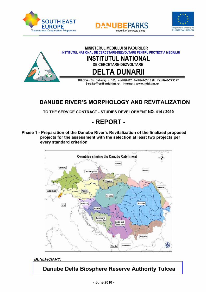
The DRB covers a total area of 801.000 km² and collects water from the
territories of 19 countries in Central and South-Eastern Europe (Germany, Austria,
Switzerland, Italy, Poland, the Czech Republic, Slovenia, Slovakia, Hungary, Croatia,
Serbia, Romania, Bosnia and Herzegovina, the Former Yugoslav Republic of
Macedonia, Albania, Montenegro, Moldova, Bulgaria, and Ukraine)
Today, 83 million people inhabit the DRB, and 60 cities in the DRB have a
human population of more than 100.000 (after Sommerwerk et al., 2009, quoted by
Sommerwerk N. et al., 2010). Culturally, the DRB consists of a wide variety of
languages, traditions, histories and religions. The political and social conditions and
the corresponding economic status of the DRB countries are more diverse than those
in any other European river basin.
The Danube is the second longest river in Europe (2826 km), and its large
delta forms an expansive wetland (area: 5640 km²) of global importance. The mean
annual discharge of the Danube at its mouth is 6480 km³/s, corresponding to a total
annual discharge of 204 km³. The Danube is divided into three sections that are
almost equally long, and separated by distinct changes in geomorphic
characteristics: the Upper, Middle and Lower Danube. A characteristic feature of the
Danube is the alternation between wide alluvial plains and constrained sections
along the main stem. Before regulation, active floodplain width reached > 10 km in

9
the Upper Danube and > 30 km in the Middle and Lower Danube. In the Upper
Danube, most floodplains and fringing wetlands have been converted into agricultural
and urban areas, or have been isolated by dams and artificial levees, and therefore
are functionally extinct. However, along the Middle and Lower Danube, large near-
natural floodplains still remain. Vegetated islands form another (former) prominent
landscape element in the DRB. Along the Austrian Danube, 2000 islands were
present before regulation today, only a few remain. However, islands are still
abundant in the Hungarian/Serbian (Middle Danube) and the Bulgarian/Romanian
sections (Lower Danube). Remaining near-natural floodplains and vegetated islands
may serve as important nuclei for conservation and management actions; at the
same time, they are sensitive indicators to assess the ecological state of river
corridors (after K. Tockner, unpubl. data, quoted by Sommerwerk N. et al., 2010).
Zoogeographic and phylogeographic studies clearly pinpoint the DRB as a
biodiversity hot-spot region in Europe. For example, 20% (115 native species) of the
European freshwater fish fauna and 36% (27 species) of the amphibian fauna occur
in the DRB today (after Sommerwerk et al. 2009, quoted by Sommerwerk N. et al.,
2010).
Moreover, the Palaearctic and Mediterranean biogeographic zones overlap in
the Danube Delta, resulting in an exceptionally high biodiversity, especially for birds
(total: 325 species, 50% are breeding species). The corridor of the Danube River
remained unglaciated during the last ice age and therefore served as a substantial
glacial refuge area, as well as an important expansion and migration corridor for
many species. Today, the DRB drains areas of nine ecoregions (after Illies, 1978,
quoted by Sommerwerk N. et al., 2010).
Key water management issues
The Danube Basin Analysis in 2004 provided the first comprehensive
characterization of the entire DRB (ICPDR, 2005). It comprised a basin-wide
pressure and impact analysis to estimate the risk for water bodies of failing the
management objective of the EU Water Framework Directive (WPD), i.e. to achieve
‘good ecological status’, by 2015 (European Commission, 2000). Mitigating
hydromorphologic alterations, and reducing organic pollution, nutrient loads, and
hazardous substances, have been identified as the main targets for the Danube

10
River Basin Management Plan (ICPDR, 2009). However, transport and
contamination of sediments, as well as the spread of invasive species, have not yet
been given sufficient attention. Adaptive strategies that take future global change into
consideration are also missing.
Hydromorphological alterations
Hydropower generation, flood protection, land reclamation, and navigation are
the main driving forces for hydromorphologic alterations in the DRB. Approximately
700 major hydraulic structures (dams and weirs >15 m), including 156 large
hydropower dams, have been built in the DRB (after Reinartz, 2002; Bloesch, 2003;
ICPDR, 2005, quoted by Sommerwerk N. et al., 2010).
Approximately 30% of the length of the main stem is impounded through 78
major hydraulic structures. Less than 15% of the Upper Danube remains free-flowing.
The largest dams in the DRB are the hydropower plants fron Gate I and II (built in the
1970s) in the downstream part of the Middle Danube (Rkm 943 and Rkm 842). The
Iron Gate dams, together with the Gabčikovo dam in Slovakia (built in the 1980s),
disrupt fish migration in the Lower and Middle Danube, and significantly alter the
sediment and groundwater regime (after Zinke, 1999; Kiaver et al., 2007, quoted by
Sommerwerk N. et al., 2010).
As of 2009, 22 of the 78 barriers are passable for fish (ICPDR, 2009).
Notable areas of the Danube Delta have been embanked and drained, and the
total length of the channel network in the delta doubled between 1920 and 1980 (at
present 3500 km: after Gastescu et al., 1983, quoted by Sommerwerk N. et al.,
2010).
The new Bystroye navigation-canal has cut through the Ukrainian part of the
Danube Delta biosphere reserve since 2004.
Currently, the Danube is navigable for 87% of its total length (upstream to
Rkm 2410). Approximately 1100 ships are registered along the Danube River (after
www.icpdr.org, www.ccr-zkr.org, quoted by Sommerwerk N. et al., 2010).
The registered vessels along the Danube are 40 years old on average.
Therefore, emission standards are most likely not up-to-date. The remaining free-
flowing river sections and their mobile beds have been identified as ‘bottlenecks’ for
11
navigation. Hence, the creation and maintenance of a continuous shipping channel of
2.8 m water depth and 160-180 m width, for most of the year, has been proposed.
Thus, the Trans-European Transportation Network (after TEN-T, ‘Corridor VII’,
http://tentea.ec.europa.eu/, quoted by Sommerwerk N. et al., 2010), of the EU
competes with the concurrent projects to conserve unique habitats and species along
the Danube River.
Alterations of the sediment regime
The dams along the main stem have severely interrupted sediment transport
in the Upper Danube. The Iron Gate dams retain approximately two-thirds of the
suspended solids. Therefore, sediment delivery to the Delta decreased from 53 to 18
million tone/year, resulting in severe coastal erosion (after WWF, 2008, quoted by
Sommerwerk N. et al., 2010). River-bed incision further reduces low water levels and
impedes the hydrological connection between the channel and its floodplains.
To mitigate the adverse effects of river-bed incision in the Upper Danube
(downstream of Vienna, Rkm 1921-1880), the river bed will be stabilized by adding
coarser gravel, and by widening the main channel by removing 50% of the artificial
bank protections (riprap) (after Reckendorfer et al., 2005, quoted by Sommerwerk N.
et al., 2010). In addition, the bedload sediment deficiency is balanced by annual
additions of 160.000 t of gravel, corresponding to 20% of the load in 1850. These
joint measures should lead to an 85% reduction in bed incision (WWF 2008).
Commercial dredging is mostly banned in the Upper Danube, and dredged material
is returned to the main stem (‘no-net-loss’). In the Middle and Lower Danube,
stopping the ongoing sediment removal remains an urgent issue.
Water pollution
Despite an overall improvement in water quality over the past few decades,
the Danube and its tributaries remain exposed to multiple point and non-point
pollution sources (after Schmid, 2004; Behrendt et al., 2005; Liška et al., 2008,
quoted by Sommerwerk N. et al., 2010). The construction and upgrade of wastewater
treatment plants (WWTP) have reduced the input of biodegradable organic matter in
the Upper Danube during the past three decades (after Wachs, 1997, quoted by
12
Sommerwerk N. et al., 2010). In the Middle and Lower Danube, water quality
remained relatively high until the 1970s, but then deteriorated owing to rapid
industrial development, poor pollution control, and inputs from heavily-polluted
tributaries (after Russev, 1979; Kalchev et al., 2008, quoted by Sommerwerk N. et
al., 2010). However, the high self-purification capacity of the remaining natural river
sections and alluvial wetlands has buffered these adverse effects, and at the same
time has maintained a relatively high biodiversity up to now (after UNDP/GEF, 1999,
quoted by Sommerwerk N. et al., 2010). Large cities along the main stem, like
Belgrade and Budapest, or Bucharest along the tributary Arges, still lack WWTPs. In
Budapest, a WWTP is under construction. The Budapest Central Wastewater
Treatment Plant project is the largest environmental investment to be actually
implemented in Central Europe (total costs €530 million: after ICPDR, 2010a, quoted
by Sommerwerk N. et al., 2010). Zagreb, located along the Sava River, has recently
completed a new facility.
The Danube discharges 29 kt y -1 of total phosphorus (TP) and 478 kt y -1 of
total nitrogen (TN) into the Black Sea. Despite the achieved reductions, pollution
loads are still high enough to threaten the unique biodiversity and affect the fishery
and recreational value of the Black Sea (after United Nations, 1997, quoted by
Sommerwerk N. et al., 2010).
Hazardous substances like heavy metals, persistent organic pollutants
(pentachlorophenols, PCPs; polycyclic aromatic hydrocarbons, PAHs, and
organochlorine pesticides), hormone active substances and micro-pollutants are
becoming an increasing issue in the DRB. Contaminations of sediments with DDT
(dichlorodiphenyltrichloroethane) are common in the Lower Danube. However there
is a lack of legal measures for obligatory monitoring of some of these hazardous
substances. In the downstream DRB countries, adequate analytical equipment is
also lacking. The International Commission for the Protection of the Danube River
(after ICPDR, www.icpdr.org, quoted by Sommerwerk N. et al., 2010) and the Black
Sea Commission have put the reduction of hazardous substances as a high priority
issue on their agenda. The improvement of WWTPs and the application of best-
available techniques for the industrial and agricultural sectors are considered as the
most efficient measures to reduce the emissions of toxic substances, as well as of
nutrients and organic matter.
13
Non-native and Invasive species
For centuries, European inland waterways have provided opportunities for the
spread of non-native aquatic species. At present, a complex network of more than
28000 km of navigable rivers and canals connects 37 European countries, creating a
biological ‘meta-catcbment’ that encompasses large parts of the continent (after
Panov et al., 2009, quoted by Sommerwerk N. et al., 2010). The Danube River
belongs to the Southern Invasive Corridor that links the Black Sea with the North Sea
via the Rhine-Main-Danube Canal.
At present, 141 alien and cryptogenic taxa (41 fish, 67 macroinvertebrate, 24
aquatic macrophyte, 1 amphibian, and 8 parasite species) have been reported for the
DRB (www.alarmproject.net). Several non-native species are true invasive species
that currently represent prevalent components of the aquatic community: Corbicula
fluminea (Asian clam); Anodonta woodiana (Chinese pond mussel); Orconectes
limosus (spinycheek crayfish), and Dreissena polymorpha (zebra mussel) (after Liška
et al., 2008; Graf et al., 2008, quoted by Sommerwerk N. et al., 2010). New
introductions are constantly recorded (after e.g. LeppilkOski et al., 2002;
Arbaçiauskas et al., 2008, quoted by Sommerwerk N. et al., 2010). The Ponto-
Caspian Region not only serves as a suitable recipient for non-native species, but is
also a key European ‘donor area’ for alien species.
The quantification of non-native species was a key focus of the Joint Danube
Survey 2 (after Liška et al., 2008, quoted by Sommerwerk N. et al., 2010). There is
clear evidence that channel stabilization and construction of artificial banks have
favored the establishment of non-native species. Therefore, restoring
hydrogeomorphic dynamics is expected to mitigate the spread of invasive species, as
pioneer habitats are less prone to the establishment of non-native species (after
Tockner et al., 2003, quoted by Sommerwerk N. et al., 2010).
Little is known about the ecosystem consequences of novel communities that
are composed of a mixture of native and non-native assemblages. In addition, we
need to improve our understanding of the interactions of species invasion with other
pressures in order to better manage invasive species in the DRB. It will be important
to apply risk assessment procedures and use those results for priority actions to
reduce the rate of aquatic invasions and to combine these actions with awareness-
raising measures in water management and the public (after Panov et al., 2009,
14
quoted by Sommerwerk N. et al., 2010). It is also questionable whether all measures
should be based on the a priori assumption that non-native species have a negative
ecological and economic impact.
Legal frameworks of the DRB
A long history in developing and establishing national and international legal
frameworks exists along the Danube River (after Bogdanovic, 2005, quoted by
Sommerwerk N. et al., 2010). However, to manage a river basin as diverse and
complex as the DRB poses major legal and political challenges to the public and
stakeholders at various hierarchical levels. Since 2000, the WFD forms the guiding
legal principle for the management of the DRB. The ultimate goal of the WFD is to
achieve good ecological (and chemical) status for all surface waters by 2015 (with
possible extensions to 2027). Basic elements to define good ecological status are the
ecoregion, river type, and reference state, as well as the composition of aquatic
assemblages (after Moog et al., 2004; ICPDR, 2005, quoted by Sommerwerk N. et
al., 2010). If restoring good ecological status causes disproportionate costs or
adverse effects on the environment and human society, water bodies might be
designated as ‘heavily modified’. As such, ‘good ecological potential’ and ‘good
surface water chemical status’ must both be achieved.
The ICPDR, founded in 1998, is responsible for the implementation of the
WFD in the DRB. The Danube River Protection Convention (DRPC) forms the
political framework that underpins the international cooperation within the ICPDR
Fourteen out of the 19 DRB countries are contracting parties and legal members of
the DRPC. In addition, the European Commission is a contracting party. Italy,
Switzerland, Poland, Albania, and the Former Yugoslav Republic of Macedonia,
which have only minor shares in the DRB, cooperate with the ICPDR. The WFD
implementation is legally binding for the EU Member States of the DRB. Further,
contracting parties that are non-EU Member States have made a voluntary
commitment to implement the WFD under the DRPC. This undertaking represents a
major step forward to the overall DRB management strategy, as well as to the
environmental administrations of the respective countries.
The secretariat of the ICPDR coordinates the work of national delegates (i.e.
high-ranked governmental representatives) and technical experts, integrates the
15
members of the public, and cooperates with the scientific community. The ICPDR
jointly prepares the content and calls for project tenders, as well as the documents
for the implementation of the water protection and conservation issues, to be ratified
by the national governments. The Roof Report (ICPDR, 2005), the Joint Danube
Surveys (in 2001 and 2007), the Issue Paper on Hydromorphological Alterations
(ICPDR, 2007a), the Action Program on Sustainable Flood Protection (ICPDR,
2004), the DRBM Plan (ICPDR, 2009), and the establishment of public participation
strategies, are so far the main deliverables provided by the ICPDR. In ICPDR are
sub-basin activities for the Danube Delta as well as for the Tisza and Prut Basins. An
international commission had been established for the Sava River Basin (after
www.savacommision.org, quoted by Sommerwerk N. et al., 2010).
The Espoo Convention 1991 on Environmental Impact Assessment in a
transboundary context (after www.unece.org/env/eia, quoted by Sommerwerk N. et
al., 2010) helps to solve environmental problems across political borders (e.g. for the
Bystroye navigation-canal in the Danube Delta, bordering Romania and Ukraine).
Finally, the Danube-Black Sea Joint Technical Working Group coordinates the work
of the ICPDR and the International Commission for the Protection of the Black Sea,
in particular to develop strategies for reducing nutrient inputs into the Black Sea.
The Belgrade Convention on Danube Navigation, the EU Flood Directive, and
the Floods Action Program aim to further expand inland navigation and to implement
flood control programs (European Commission, 2004; European Commission, 2007).
However, these aims compete with that of the EU WFD, which states that the
ecological integrity of surface waters must not deteriorate further. The EU Flood
Directive itself is controversial in its recognition of the natural retention capacity of
floodplains. Despite the various environmental directives, the Danube has been
defined as a priority-axis of the TEN-T. In particular, the few remaining large
floodplains along the Lower Danube River, as well as along the Sava, Drava and
Tisza Rivers, are threatened by these navigation plans (after Schneider, 2002; WWF,
2002, quoted by Sommerwerk N. et al., 2010). Although these floodplains provide
invaluable ecosystem services (i.e. water storage, recharge of groundwater, nutrient
retention, retention of suspended and dissolved materials, biodiversity ‘hot spots’,
ecotourism), these services remain mostly neglected by politicians. Given the
expected increase in economy and large infrastructure projects in the DRB,
sustainable strategies are required (after e.g. Brundic et al., 2001; for Middle Sava,

16
quoted by Sommerwerk N. et al., 2010). The Joint Statement on Inland Navigation
and Environmental Sustainability in the DRB aims to develop new navigation
strategies (after ICPDR, 2007b, quoted by Sommerwerk N. et al., 2010). The feasible
first steps to a more sustainable DRB inland navigation are to modernize the vessels
and harbors along the Danube, and to harmonize the TEN-T guidelines with the WFD
objectives (after WWF, 2005, quoted by Sommerwerk N. et al., 2010). Another step
forward was the elaboration of the PLATINA-Manual for sustainable navigation where
environmental aspects are respected and balanced with economic development
(after ICPDR, 2010b, quoted by Sommerwerk N. et al., 2010).
Legal protection of endangered species remains a specific problem. For
example, five out of six sturgeon species native to the DRB are critically threatened
by extinction, and one species (Acipenser sturio) is already extirpated. The Sturgeon
Action Plan, within the framework of the Bern Convention on the Conservation of
European Wildlife and Natural Habitats, stipulates the reopening of sturgeon
migration routes by making the Iron Gate hydropower dams passable and by
conserving key habitats for recruitment (after Bloesch et al., 2006, quoted by
Sommerwerk N. et al., 2010). Further, the Convention on International Trade in
Endangered Species (after CITES, www.cites.org, quoted by Sommerwerk N. et al.,
2010) regulates the trade of sturgeons and their products.
Pollution remains an important issue in the DRB. Since 2007, industrial
emissions are regulated by the Integrated Pollution Prevention and Control (IPPC)
Directive. Various directives are in force, some under the WFD, which serve as legal
guidelines and back up international conventions to support river and wetland
protection, conservation and management. All quoted conventions have been ratified
by the majority of the DRB countries and are therefore legally binding, at least in
theory. There is emerging mutual understanding among the Danube countries that
the principles of ‘polluter and user pays’ (e.g. for pollution), ‘solidarity’ (e.g. for
sturgeon protection), and ‘precaution and prevention’ (e.g. for flood protection)
should be implemented. The application of economic instruments in water
management is generally perceived as an effective tool to promote the protection of
the environment (after Speck, 2006, quoted by Sommerwerk N. et al., 2010). For
example, the ‘polluter pays principle’ forms the base of all European environment
policies; it implies that people and private industries, but not the public and tax
payers, should pay the damages and environmental impacts they cause through their
17
activities. This principle is actually transferred to other sectors such as the ship-waste
management sector (after www.wandaproject.eu, quoted by Sommerwerk N. et al.,
2010). However, in the downstream DRB countries, the alignment and harmonization
of the legal frameworks with EU policies, as well as its enforcement, are far from
being satisfactory (after Speck, 2006, quoted by Sommerwerk N. et al., 2010). The
precaution-principle (e.g. through preventing accidental spills) and the solidarity
principle are complementary and must be ensured because impacts of upstream
pollutants may cause major damages to downstream communities. Additional
pressure towards reductions in pollution was gained by the Protocol on Pollutant
Release and Transfer Registers. Internationally binding, it gives the statutory right to
the public to have free access to emission data in national pollutant release and
transfer registers.
Unfortunately, where economy meets ecology, the former is usually the winner
(after Tockner and Stanford, 2002, quoted by Sommerwerk N. et al., 2010). Political
compromises are inevitable, need to be based on scientific concepts for river basin
management, and must include participatory methods to achieve win-win situations
among the different user groups (after Bloesch, 2004, quoted by Sommerwerk N. et
al., 2010).
Proactive and reactive management strategies
Proactive management activities
The EU WFD considers the river basin as the key spatial unit to understand
and sustainable manage water resources. The DRBM Plan is the instrument to
ensure good status in all water bodies by 2015 and beyond (after ICPDR, 2009,
quoted by Sommerwerk N. et al., 2010).
The availability of high-quality monitoring data is crucial for the compilation of
the DRBM Plan and allows for a cost-efficient implementation of the EU WFD.
Building on existing national monitoring networks, the TransNational Monitoring
Network (TNMN) was set up in 1996 (adapted in 2006 in order to comply with WFD
requirements) under the umbrella of the ICPDR. The revised TNMN includes 81
monitoring stations that provide a basin-wide overview of the status and the long-
term trends of surface and ground water quality (after ICPDR, 2009, quoted by
Sommerwerk N. et al., 2010). The TNMN data are checked via an analytical quality
18
control program by a network of 69 national laboratories quarterly and the results are
published annually (after ‘QualcoDanube’, VITUKI, 2009, quoted by Sommerwerk N.
et al., 2010).
The monitoring efforts through the TNMN have been supplemented by
‘Danube expeditions’: two Joint Danube Surveys (JDS 1 in 2001 and JDS 2 in 2007)
were earned out by multidisciplinary teams of scientific experts. These international
expert teams collected hydromorphologic, physico-chemical, and biological data
along the entire Danube main stem, as well as along selected tributaries, in a
standardized way. In total, 280 environmental parameters were evaluated. Despite
limitations owing to the snapshot character, the results of both JDS provide a useful
scientific basis for the further improvement of DRB management strategies, and
concurrently stimulate the dialogue with different stakeholder groups. Furthermore,
the surveys provided the opportunity to check the comparability of the nationally
applied WFD-compliant sampling and assessment methods, as well as to train field
and laboratory staff.
The JDS are supported by the DRB governments, private and public-run
laboratories, private companies, and local authorities and NGOs. The ‘Danube
expeditions’ received major attention by the media and therefore helped to enhance
public awareness about the multiple threats in the DRB (www.icpdr.org/jds/). It is
planned to repeat the JDS at six-year intervals to detect long-term trends, at a high
spatial resolution, and to assess the success of the DRB management strategies.
A comparative and consistent water quality classification and status evaluation
is a legally binding requirement of the WFD. At the European and DRB level, this
task of benchmarking is subsumed as ‘intercalibration’ (European Commission,
2005). The purpose of the intercalibration exercise is not to harmonize assessment
systems, but their results. The exercise aims to ensure that good ecological status
represents the same level of ecological quality throughout Europe. For large and
lowland rivers, near-natural reference sites are absent; therefore, intercalibration
approaches for impacted conditions were developed (after Heiskanen et al., 2004;
Birk and Hering, 2009, quoted by Sommerwerk N. et al., 2010). Owing to data gaps,
and because national WFD-compliant assessment methods were not developed to a
sufficient extent, not all biological quality elements in all water categories have been
intercalibrated within the first phase of the intercalibration exercise between 2005 and

19
2007. The exercise should be finalised by the end of the second phase (2008-2011).
Moreover, the assessment of the ecological status of large rivers, such as the
Danube, has been recognized as a particular challenge, and is dealt with by specific
working groups at the DRB and the European level (after ICPDR, 2009, quoted by
Sommerwerk N. et al., 2010).
Proactive management options for nutrient reduction
The model MONERIS (Modeling Nutrient Emissions into River Systems) was
used to quantify point and diffuse source emissions for seven emission pathways
into surface waters as well as in-stream retention processes (after Venohr et al.,
2010, quoted by Sommerwerk N. et al., 2010). In addition, management options are
implemented in the model that can be evaluated according to their potential to reduce
nutrient emissions (after Behrendt et al., 2002; Schreiber et al., 2005, quoted by
Sommerwerk N. et al., 2010). Based on this model, a total of 650 kt (49% agricultural
sources) of nitrogen (N) and 53.5 kt (62% urban sources) of phosphorus (P) are
emitted into the DRB annually (2005 is used as a reference year); whereas geogenic
background emissions only contribute 7% for N and 12% for P to the current loads.
A major management goal for the DRB is to reduce the nutrient load to the level
observed in the 1960s (MoU ICPDR-ICPBS, 2001). This requires a 40% and 20%
reduction for N and P loads, respectively. Of all the suggested measures,
establishing efficient WWTPs has the greatest N-reduction potential (-5%). The
reduction of atmospheric deposition of NOx (-4%), altered N-surplus (-2%) and
reduced soils loss (1%) would also further reduce N emissions.
In all DRB countries, except Germany, Austria, Romania, and Slovenia,
agricultural land use is predicted to increase until the year 2015. As a consequence,
N emissions will most probably increase, which could counteract the reduction effects
accomplished through other measures. Phosphate emission in the DRB via
household detergents is also significant. Up to now, only Germany and Austria have
imposed bans on phosphate in laundry detergents. However, this ban does not apply
to dishwasher detergents, and these remain an emerging pollution pathway.
Nevertheless, the reduction potential of a P ban in laundry detergents amounts to
14% and 21.2% in the Middle and Lower Danube.
20
Measures to prevent soil loss from arable land could further reduce
phosphorus emissions considerably (up to 14% reduction when applied to all arable
land). This is an important measure in the Upper Danube where other options are
less effective. In combination, all measures can reduce N and P by 8 and 40%,
respectively. However, for N, the management objective, as stated in the DRBM
Plan, cannot be achieved by 2015 (after ICPDR, 2009, quoted by Sommerwerk N. et
al., 2010).
Proactive management of protected areas
Within the DRB, 1071 freshwater protected areas (>500 ha) have been
identified (after ICPDR, 2009, quoted by Sommerwerk N. et al., 2010). However, it is
difficult to estimate the total area of protection sites within the DRB because various
protection categories spatially overlap. For example, parts of the Danube Floodplain
National Park east of Vienna (Austria) are concurrently designated as a
NATURA2000 site, Ramsar area, UNESCO Biosphere Reserve, National Park,
Nature Reserve, IBA (Important Bird Area) and Protected Landscape. Moreover,
there is variation throughout the DRB countries whether aquatic ecosystems are the
focus of protection, and categories like ‘National Park’ and ‘Nature Reserve’ are often
not in accordance with the international categories of the IUCN (after Dudley, 2008,
quoted by Sommerwerk N. et al., 2010). The different uses and protection categories
of freshwater reserves can be attributed to the biogeographic setting, the uneven
economic development of the DRB, and different stressors that act in the different
regions. Although water abstraction for irrigation and chemical pollution are major
stressors in SE Europe, hydropower generation, flood protection and navigation (i.e.
hydromorphologic alterations) dominate in Central and Western Europe. Protected
areas that are managed by an administrative authority usually belong to the highest
conservation category. The Accessory Publication (Part A) lists these protected areas
along the Danube River and its major tributaries.
The NATURA2000 concept constitutes the first uniform definition of habitat
types to be protected in Europe. Special Protection Areas (SPAs) under the Birds
Directive (Directive 2009/1471EC) as well as the protection of threatened (Red List)
species protected by the Bern Convention are integrated into the NATURA 2000
network. Along the main stem of the Danube River, 117 NATURA2000 sites, ranging

21
from 30 ha to 600.000 ha, have been designated for the protection of habitats and
species (European Environment Agency, DG ENV E2). This number will most likely
grow when non-EU Member States, after accession, designate their NATURA2000
sites. The standardized NATURA2000 rules allow EU citizens to have actions that
might be destructive to the environment assessed via the European Commission,
mostly independent of local or governmental interests. However, the implementation
and adjustment of the NATURA2000 network is a long-term endeavour. Criticism has
been made with regard to the: (i) doubtful representativeness of the nominated
sites; (ii) the often small area coverage of the sites; (iii) the insufficient update of
the lists of protected species and habitats, and (iv) the spatial isolation of the
individual sites.
The NATURA2000, as well as other protection measures such as the Ramsar
Convention and the WFD, should not be regarded as the end points of the EU
conservation policy (after Maiorano et al., 2007, quoted by Sommerwerk N. et al.,
2010). There is urgent need to simplify and properly harmonize existing protection
concepts and directives, as well as to incorporate them into a general nature
conservation strategy. Additionally, advanced reserve network designs, such as the
concept of ‘Key Biodiversity Areas’ (KBAs), are currently under development (after
Langhammer et al., 2007; www.freshwaterbiodiversity.eu, quoted by Sommerwerk N.
et al., 2010). They are envisaged to allow for a more effective protection of species
and prioritization of sites for conservation. However, all protection categories outlined
above focus on the preservation of the environmental status quo and consider the
structure rather than the function of ecosystems as the main conservation target.
Currently, the remaining ecologically-valuable river sections of the Danube are
at high risk because of large-scale navigation and flood management plans.
Therefore, in 2007 the representatives of the large protection areas within eight
Danubian countries launched the initiative for a Danube River Network of Protected
Areas (‘Danubeparks’; funded by the EU SE Europe Transnational Cooperation
Program, www.danubeparks.org). The main goals of this initiative are to: (i) exchange
experiences in river restoration and invasive species control; (ii) propose
management strategies for sustainable sediment balances, nutrient control, inland
navigation and hydromorphologic integrity; (iii) conserve flagship species such as
sturgeons and the white-tailed eagle; (iv) act as an observer within the ICPDR and to
advocate for large protected areas as part of basin-wide management strategies; (v)
22
promote the implementation of the NATURA2000 concept and of transnational
monitoring programs; (vi) implement a basin-wide public relation program for nature
conservation, and (vii) stimulate eco-tourism.
Reactive management strategies: restoration
Nature restoration is a thriving enterprise worldwide. This is also true in the
DRB. Some case studies are outlined in the Accessory Publication, Part B. In the
Upper Danube Basin (Germany, Austria), channel widening, re-connection of side-
arms, shoreline restoration, and re-establishing the continuum for migratory fish and
benthos are the main activities (e.g. near Ingolstadt, Germany; in the Wachau valley,
Austria). In the Middle Danube, restoration projects mostly focus on the re-
connection of former side-arms. In the Lower Danube, large sketches have been
embanked and restoration projects focus on the integration of former floodplains and
wetlands into the river flow regime (e.g. Bulgaria opening of polders in the Danube
Delta, Romania).
River restoration projects along the Danube are mostly designed and
implemented locally. Usually, national river engineering administrations constitute the
highest level of planning. Moreover, cultural diversity and political and language
barriers hinder the exchange of experiences regarding the design and
implementation of river restoration strategies. Proper monitoring (i.e. assessing
success) is mostly lacking. The Danube River Network of Protected Areas aims to fill
these gaps and to serve as an adequate future information platform
(www.danubeparks.org).
The ICPDR initiated a spatially-explicit prioritization approach for restoration,
with a focus on fish species migrating long and medium distances in the DRB.
Barrier-free fish migration along key migration routes is envisaged by 2015 (ICPDR
2009). Barriers along the main stem and close to the mouth of major tributaries need
to be re-opened first for achieving this high priority goal.
23
Challenges and recommendations for the sustainable development
of the Danube River Basin
‘Sustainable management’ of ecosystems is a buzzword that is highly popular
among and scientists. However, to properly define this concept and to implement it
into a river basin management plan remains a major challenge that requires tight
feedbacks between science and application (after Bloesch, 2005; Eberhard et al.,
2009, quoted by Sommerwerk N. et al., 2010). Therefore, the European Union, along
with national governments, has invested considerable financial resources in
supporting the scientific community in the DRB during the past decades. However,
the knowledge gained through supported projects is not yet efficiently implemented
into management programs and legislative tools (after Kramer and Schneider, 2010,
quoted by Sommerwerk N. et al., 2010). The science-policy integration is often
hindered by inadequate communication and the lack of access of adequate scientific
results. Therefore, the ‘portal for science and technology transfer to policy making
and implementation of integrated water resources management’ was launched in
2007 as part of the Water Information System for Europe (WISE RTD web portal,
www.wise-rtd.info). Projects that are funded via the Seventh Framework Program of
the European Community have to allocate a certain amount of the budget to involve
‘communication with non-academic partners’. These dissemination efforts are
expected to be part of the project evaluation (after Holmes and Scott, 2010 quoted by
Sommerwerk N. et al., 2010). Despite the existence of these web portals and
communication obligations, the transfer of scientific results into practice remains
suboptimal (after Kramer and Schneider, 2010, quoted by Sommerwerk N. et al.,
2010). It is therefore crucial that scientific experts actively participate and expose
themselves in the public political discussion; for example, as members of the local
and regional parliament. Unfortunately, scientific career-reviewing schemes rarely
give credit to efforts for the integration of knowledge to fulfill policy objectives (after
Quevauviller, 2006, quoted by Sommerwerk N. et al., 2010). In addition, the scientific
community needs to come up with a clear concept of environmental services that can
be integrated into management strategies. If this issue stays under dispute within the
community, its persuasive power is weakened.
24
The identification of research needs and the setting of research agendas have
to be an ongoing process and should not only start when an urgent problem emerges
(after Holmes and Scott, 2010, quoted by Sommerwerk N. et al., 2010). Thus,
effective science-policy integration requires joint framing and planning of fundamental
and applied research, the presence of policy makers and stakeholders on research
steering boards, and an agreement on clear environmental targets. What we urgently
need are quantitative tools that allow us to predict the effects of management options
under rapidly changing environmental and political conditions. In addition, we need to
develop spatially-explicit priorities for conservation and restoration. Further, synergies
among the presently competing targets such as navigation, biodiversity conservation,
and flood control need to be established. In this respect, the ecosystem service
concept might be very promising for the management of ecosystems that are under
multiple uses.
In Europe, but also globally, the establishment of catchments commissions for
transboundary rivers is a major step forward in integrating science-policy activities.
For example, the ICPDR, with its seven technical expert groups and network of
observers, is an important platform for dialogue and debate. The members of the
secretariat have a scientific background, and thus function as ‘translators’ of research
outcomes into management practice. Moreover, the ICPDR initiates programs like
the JDS, serves as a member in the advisory board for several initiatives such as the
WISE-RTD portal, and presents the DRBM Plan on scientific conferences. A special
website has also been launched that actively involves the public in the preparation of
the DRBM Plan (www.icpdr.org/participate). This more holistic approach allowed for
the recognition of cause-effect chains and the formulation of measures to properly
address them.
Despite progress, many obstacles undermine the implementation of the DRBM
Plan. The distinct west-east (upstream-downstream) gradient matters with regard to
economic wealth, and many large projects funded through international programs
(e.g. EU-Phare, World Bank) did not meet their goals and were unsuitable for the
long-term capacity building within the DRB. For example, installing modem chemical
laboratories is useless if the necessary experts are not yet available. Hence, there is
a need for step-by-step procedures that progressively introduce new skills and
technologies in this region (after Harremoës, 2002, quoted by Sommerwerk N. et al.,
2010).

25
-
Bureaucracy, corruption, and politicians ignoring the current best science can
hinder the implementation of effective management strategies. This is particularly the
case in the downstream DRB countries. For example, ongoing poaching of
endangered sturgeons in the Danube Delta undermines the implementation of
sturgeon protection strategies and CITES regulation. Although Romania banned
commercial fishing and the trade of wild sturgeon products for a 10-year period, the
enforcement and therefore the efficacy of this ban, is doubtful.
The lack of political willingness at the national level can undermine the
implementation of the WFD. A stronger involvement of the public and of the
stakeholders, as required by the WFD and the Aarhus Convention, may support the
implementation of management practices. However, participatory processes to
finding agreed solutions need to be taught are laborious, time-consuming, and slow-
particularly when stakeholders are involved.
A few decades ago, the construction of large dams at the Iron Gate and
Gabčikovo, as well as the memorable occupation of the Hainburg floodplains in
Austria, were subjects of great public debates. Present ‘hot spots’ of controversy are
large-scale river regulation projects for navigation and flood control. A major
challenge is to produce sound environmental impact assessments based on
published and ‘grey literature’ data, in situ investigations, a good monitoring strategy,
and optimized measures of impact mitigation. In this respect, the Directives on
Environmental Impact Assessment (EIA) and Strategic Environmental Assessment
(SEA) are starting to be properly applied in the Lower DRB. However, the great
difficulties to implement western standards of EIA is demonstrated by the ongoing
discussions about the ISPA 1 and 2 navigation projects (Instrument for Structural
Policies for Pre-Accession, TEN-T Program) in the Green Corridor.
Open discussions and the utilization of innovative strategies may lead to a
paradigm change that yields acceptable solutions to otherwise conflicting groups. For
example, in recent restoration projects along the Danube River east of Vienna,
navigation maintenance work was balanced with structural measures for improving
hydrologic and geomorphic conditions (after Reckendorfer et al., 2005, quoted by
Sommerwerk N. et al., 2010). Moreover, the ecosystem services provided by near-
natural and restored ecosystems are increasingly taken into consideration in
management strategies (after WWF 1995; Barbier et al., 1997; Schuyt, 2005;

26
Kettunen and ten Brink, 2006, quoted by Sommerwerk N. et al., 2010). Croatia, for
example doubled the size of flood retention areas based on the economic use and
non-use values of these floodplains (after Brundic et al., 2001, quoted by
Sommerwerk N. et al., 2010).
A major difficulty in the implementation of the DRBM Plan is the harmonization
of legal aspects, as well as the improvements of scientific concepts and methods to
investigate large rivers. Most DRB counties have developed their own national
standards, and ISO-standards can only provide a general guideline. Hence, method
harmonization and intercalibration is an important issue of the ICPDR (after
European Commission 2000; Birk and Schmedtje, 2005, quoted by Sommerwerk N.
et al., 2010). Furthermore, mapping of the hydrogemorphologic conditions according
to CEN-Standards provides a powerful tool for decision making (after Schwarz, 2007,
quoted by Sommerwerk N. et al., 2010).
In summary, the DRB is in a stale of fast political and environmental transition.
The political and cultural diversity within the DRB can either be considered as an
obstacle or as an asset to develop novel and innovative management strategies. The
EU WFD supports the protection and restoration of the DRB; however, it is a time-
consuming process that requires continuous support from responsible scientists and
politicians to foster public awareness and to search for sustainable solutions.
27
MATERIALS AND METHODS WITHIN PHASE’S ACTIVITIES
To accomplish this phase Preparation of the Danube River’s Revitalization of the finalized proposed projects for the assessment with the selection at least two projects per every standard criterion the following activities were achieved through different approaches:
Activity 1.1. Inventory of finalized projects for Danube River’s Revitalization.
This first activity consists in the assessment of the finalized proposed
restoration projects.
Materials: For this purpose the documentation was made from various sources of
information:
Scientific literature - books, articles and other scientific publications (e.g. Binder
W., (2008), River restoration: an European overview on rivers in urban areas. In
ECRR Conference on River Restoration; Buijse A. D. et al., (2002), Restoration
strategies for river floodplains along large lowland rivers in Europe, In
Freshwater Biology Journal; Drost H.J. et al., (2002), Research for ecological
restoration in the Dunavat-Dranov region, Danube Delta; Holubova K. et al.,
(2003), Middle Danube tributaries: constraints and opportunities in lowland, In
Lowland River Rehabilitation “An international conference addressing the
opportunities and constraints, costs and benefits to rehabilitate natural
dynamics, landscapes and biodiversity in large regulated lowlands rivers”);
Official Web sites of natural parks along the Danube bodies involved and
intenational (ECRR, WWF etc.).
Projects presentation took into account the following selection criterion:
the scientific importance of the project;
relevance of the thematic area in which the proposed theme become
employed, in relation to the dynamics of international scientific research;
contribution to scientific knowledge development;
promoted/strengthened research directions in Danube River’s Morphology
and Revitalization.

28
Activity 1.1.1. Logistics study regarding the inventory methods and means for Danube River’s Revitalization projects.
Methods: In this activity we made an inventory of the methods and means that will be applied in the next phase of the project Comprehensive Danube River’s Revitalization Assessment and preparation of the Best Practices Danube River’s Revitalization Manual, based on the previous DDNI projects experience: Integrated Management of European Wetlands (IMEW), Master Plan for Master Plan - support for sustainable development in DDBR Tulcea county/ Romania Logical Framework Analyse (LFA), Room for the River in Cat’s Bend, Romania, as fallows:
Interactive planning Sketch Match;
Focus groups and semi-structured interviews;
The tree problems.
Activity 1.1.2. Classification of Danube River’s Revitalization Project on subclasses.
Methods: Starting from The Los Angeles River Revitalization Master Plan1 developed
by City of Los Angeles department of public works were taken and adapted several
standard criterions of revitalization for Danube River, representing the base for the
following 4 criterion subclasses:
- Danube River’s restoration and rehabilitation through Lateral Connectivity;
- Danube River’s restoration and rehabilitation through Longitudinal
Continuity;
- Capture Community Opportunities;
- Create Value.
Danube River’s restoration and rehabilitation through Lateral Connectivity
During the last decades, the perception of river-floodplain systems has been
significantly improved by the application of new theoretical concepts (after Ward et
al., 2001, quoted by Buijse A. D. et al., 2002). The ‘river continuum concept’ 1 www.lariverrmp.org
29
addresses the longitudinal linkages within rivers (after Vannote et al., 1980, quoted
by Buijse A. D. et al., 2002), while the ‘flood pulse concept’ integrates the lateral
river-floodplain connections in both tropical (after Junk, Bayley & Sparks, 1989,
quoted by Buijse A. D. et al., 2002) and temperate climates (after Bayley, 1991; Junk,
1999, quoted by Buijse A. D. et al., 2002).
In most riverine systems, hydrological connectivity between the Danube River
and its floodplain is restricted to groundwater pathways; geomorphological dynamics
are mostly absent.
This second principle, lateral connectivity, focuses on the goals of developing
continuous. This is linked to an overall network of channels connections that extend
the River’s influence into adjacent neighborhood and provide ways for water
circulation in/out for wetlands. Further, the Lateral Connectivity system develops new
linkages would be created that strengthen the connectivity between riparian systems
along the Danube.
Goals of Lateral Connectivity consist in:
- create a continuous ecological corridor River Greenway, adjacent to the
Danube River consisting of the extension wetlands into Neighborhood;
- connect Neighborhood to the Danube River.
Danube River’s restoration and rehabilitation through Longitudinal Continuity
As a very long-term goal, its ecological and hydrological functioning can be
restored through creation of a continuous riparian habitat corridor within hydro
network of arms and channels and through removal of concrete walls where feasible.
While completely restoring the Danube Valley to a naturalized conditions is not likely
feasible, the restoration projects address to flood control requirements and river
channel could be naturalized in significant areas.
Three goals complement the efforts to restore river functioning ecosystems:
- enhance flood storage - focuses on off- channel storage of peak floods flows
in order to reduce flow velocities, which is a necessary precondition for
ecosystem restoration;

30
- enhance water quality - seeks to improve the quality of water within
implementation of a comprehensive, landscape-based system for filtering;
- restore the ecosystems functions - aims to restore the natural ecosystems
affected by human activity and restoration of these ecosystems function.
Capture Community Opportunities
In the past, communities have turned their back on the River, viewing it as an
unsafe, unpleasant place that primarily functions to transport flow and to form a
waterway. Constant danger of floods and the desire to obtain land for urban
development and economic activities insured against flooding works have led to
extensive damming and draining eliminating large areas of floodplains affecting
natural ecosystems. These works had negative consequences for local communities
near the river who have lost identity and traditional occupations.
By restoring lateral connectivity will be created new opportunities for local
riparian communities.
The study will identify these opportunities, how engaging residents in the
community planning process and how:
- engage residents in the community planning process and consensus building;
- provide opportunities for educational and public facilities;
- cultural heritage of the river and foster civic pride.
Create Value
Core elements of this principle include the goal of improving the quality of life
by providing new opportunities for traditional economic activities and jobs. River
Revitalization can introduce a broad range of benefits that will enhance Danube
Valley livability and result in greater economic prosperity. Goals encompass:
improve the quality of life;
increase employment;

31
create an adequate territorial planning emphasis on protecting natural and
cultural heritage, biological diversity and land use of renewable natural
resources directly benefit of local communities.
The above mentioned four criterion subclasses were related to the
FORECAST project (Facilitating the application of Output from REsearch and CAse
STudies on Ecological Responses to hydro-morphological degradation and
rehabilitation) preliminary restoration and revitalization measures (Figure 2), in order
to be analyzed in the next phase Comprehensive Danube River’s Revitalization
Assessment and preparation of the Best Practices Danube River’s Revitalization
Manual. These measures are temporary classified according to the Environment
Agency of England and Wales and River Basins Management Plans of the countries
represented in the project.
Preliminary classification of measures after FORECAST project:
to improve water flow quantity;
to improve sediment flow quantity;
to improve flow dynamics;
to improve longitudinal connectivity;
to improve river bed depth and width variation;
to improve in-channel structure and substrate;
to improve lateral connectivity;
to improve riparian zones;
to improve floodplains.
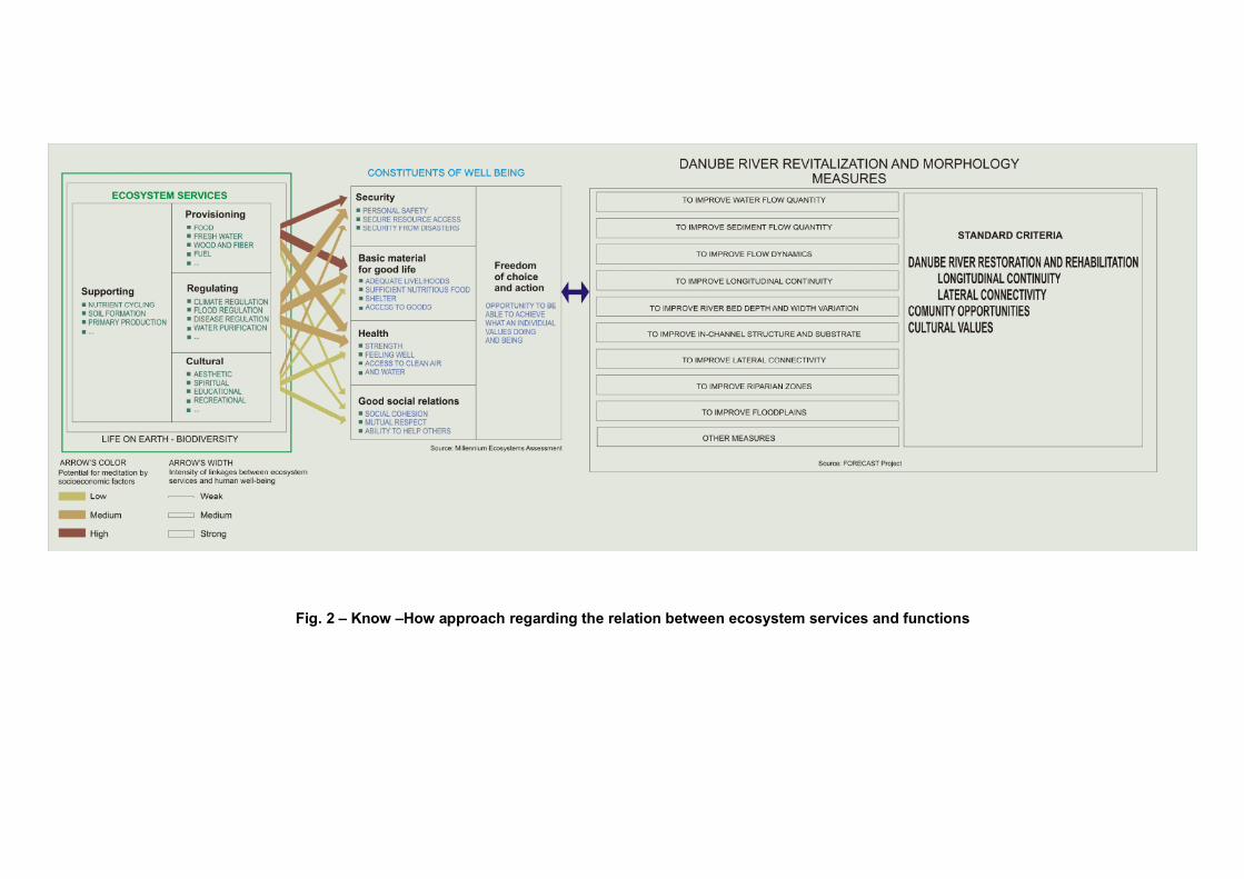
Fig. 2 – Know –How approach regarding the relation between ecosystem services and functions

33
Activity 1.2. A public debate about the Danube River’s Revitalization Projects Assessment.
DDNI Tulcea has the logistical capacity to organize a symposium (public debate). This activity will be accomplished in the next phase and its aim will be to select two projects for each subclasses of Danube revitalization and to formulate strategic guidelines for based on their implementation results.

34
RESULTS OF THIS PHASE
1.1. INVENTORY OF FINALIZED PROJECTS FOR DANUBE RIVER’S REVITALIZATION
Project name:
1. The Danube restoration project between Neuburg und Ingolstadt (Germany)
Institution:
Aueninstitut-Neuburg, Landratsamt Neuburg-Schrobenhausen
Project summary:
The study area is the Danube River between Neuburg and Ingolstadt. Along the study area since the 19th century there were a lot of changes regarding the river course. In the 1970s two additional hydropower station (Bergheim in the west and Ingolstadt in the east) were built. Due to these changes occurred in the past, today typical floodplain habitats are highly endangered. In the last 150 years 75% of the Bavarian floodplain areas were lost due to human activities (after Margraf, 2004, quoted by Stammel, 2008). In the study area, however, 2100 ha of riparian forest and riparian habitats have survived as relicts of the former floodplain. (Stammel, 2008)
The objective of the project is to restore the key hydrological and morphological dynamics which are the preconditions for the conservation of typical floodplain habitats and species (after Schiemer, 1999, quoted by Stammel, 2008). The floodplain should be reconnected to the Danube water gradually by stepwise measures. If one is able to use water as an adjusting screw, many other related features (e.g. vegetation) will adjust themselves after a certain period (after Cyffka, 2006, quoted by Stammel, 2008). Therefore, in order to restore the water and soil dynamics in the floodplain, the implementation of three measures is planned. (Stammel, 2008) Situation before restoration project:
• No river continuity; • No water and soil dynamics in the floodplain, no connection between river
and floodplain (except from flooding > 1.300 m3/s); • Partly high groundwater level; • Change of vegetation from typical riparian and floodplain species to
terrestrial or wetland species; • Lost of dynamic ruderal habitats (ox-bows, gravel banks, undercut slopes).
Idea of the project:
Hydrological process is key process for morphological dynamics and water dynamics.
35
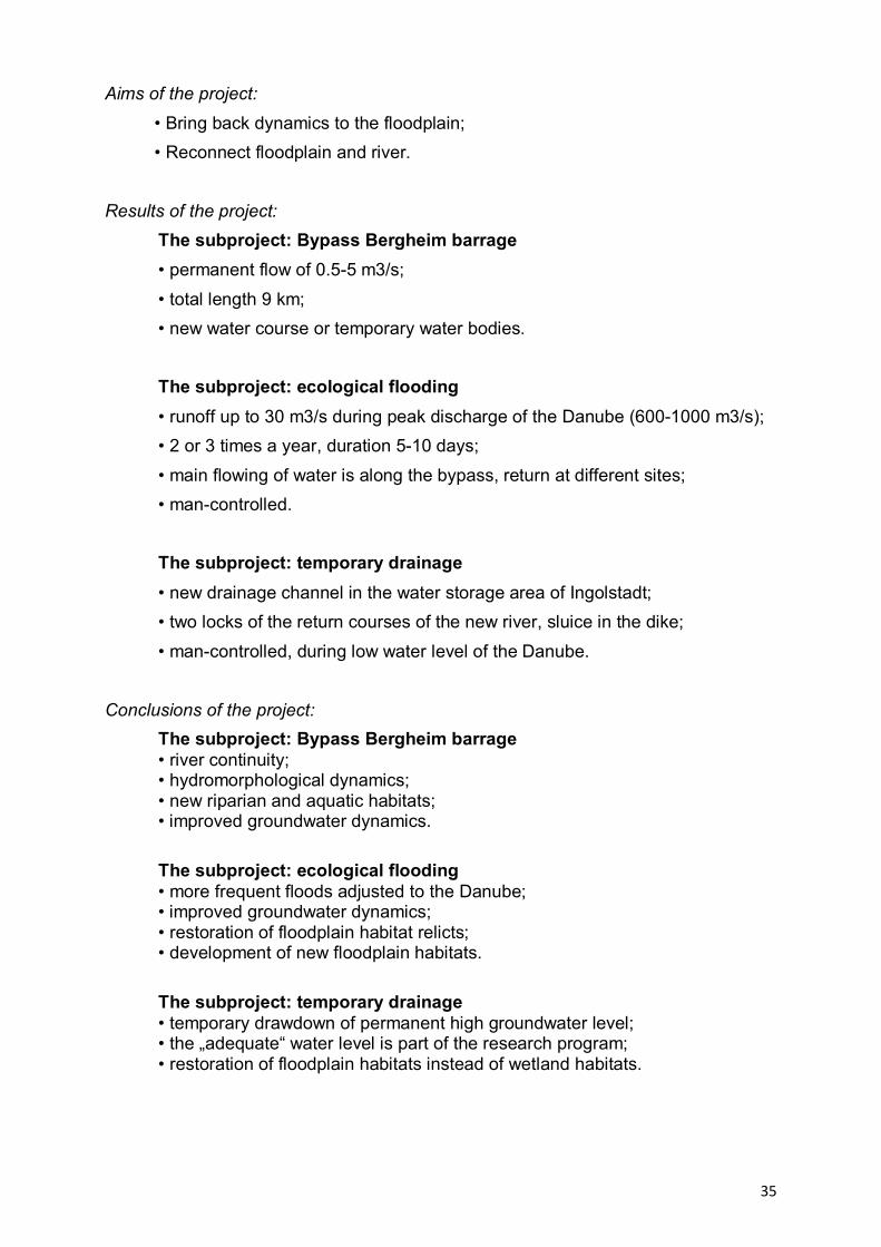
Aims of the project:
• Bring back dynamics to the floodplain; • Reconnect floodplain and river. Results of the project:
The subproject: Bypass Bergheim barrage • permanent flow of 0.5-5 m3/s; • total length 9 km; • new water course or temporary water bodies. The subproject: ecological flooding
• runoff up to 30 m3/s during peak discharge of the Danube (600-1000 m3/s); • 2 or 3 times a year, duration 5-10 days; • main flowing of water is along the bypass, return at different sites; • man-controlled. The subproject: temporary drainage • new drainage channel in the water storage area of Ingolstadt; • two locks of the return courses of the new river, sluice in the dike; • man-controlled, during low water level of the Danube.
Conclusions of the project: The subproject: Bypass Bergheim barrage • river continuity; • hydromorphological dynamics; • new riparian and aquatic habitats; • improved groundwater dynamics. The subproject: ecological flooding • more frequent floods adjusted to the Danube; • improved groundwater dynamics; • restoration of floodplain habitat relicts; • development of new floodplain habitats. The subproject: temporary drainage • temporary drawdown of permanent high groundwater level; • the „adequate“ water level is part of the research program; • restoration of floodplain habitats instead of wetland habitats.

36
Project name:
2. Bulgarian Wetland Restoration and Pollution Reduction Project (RIVER ENGINEERING) (Bulgaria)
Institution:
Bulgarian Ministry of Environment and Water under a WB Financing.
Project summary:
MWH carried out the river engineering project for the restoration of Belene
Island and the Kalimok/Brushlen wetlands on the Danube River for the Bulgarian
Ministry of Environment and Water under a WB Financing.
The Bulgarian Wetlands Restoration and Pollution Reduction Project is the
first of its kind under the umbrella of the GEF Black Sea/Danube Strategic
Partnership - Nutrient Reduction Investment Fund, a program which intends to help
riparian countries undertake investments to control or mitigate nutrient inflow to the
Black Sea. The Wetlands Restoration and Pollution Reduction Project is consistent
with the Strategic Action Plan for the protection and rehabilitation of the Black Sea
(BSSAP) and the Black Sea/ Danube Strategic Partnership. The BSSAP, formulated
with the assistance of GEF, had identified nutrient discharge as the most serious
problem facing the Black Sea. The Government of Bulgaria requested assistance
from the GEF/World Bank for undertaking an innovative approach to
wetland/floodplain restoration which linked land use change with sustainable use and
economic development.
In October 2002 the Ministry of Environment and Water launched the
implementation of activities under the Wetlands Restoration and Pollution Reduction
Project being a pilot project for Bulgaria and the Danube River downstream.
The project will assist the Government of Bulgaria in:
• restoration of critical priority wetlands in the Danube River basin and piloting the
use of riparian wetlands as nutrient traps;
• establishment of comprehensive monitoring systems for water quality and
ecosystem health;
• supporting protected areas management planning in the Persina Nature Park and
Kalimok/Brushlen Protected Sites;
37
• strengthening capacity to protect and manage biodiversity and natural resources;
• building public awareness of sustainable natural resources management and
biodiversity conservation;
• promoting and supporting entrepreneurial and agricultural activities within the
project region which ensure the sustainability of natural resources and are
compatible with biodiversity objectives.
The project assisted Bulgaria in meeting its international commitments in
relation to the Strategic Partnership for reduction of nutrient pollution in the Danube
and the Black Sea basins and the relevant requirements of the Convention for
Protection of the Danube, the Convention for Protection of the Black Sea etc. All
these activities are carried out in close cooperation with the local communities
(Nikopol, Belene, Svishtov.Tutrakan, Slivo Pole), the Belene Island prison
administration, RIEWs (Pleven, Veliko Tarnovo, Ruse), the Executive Environmental
Agency, state forestry boards in Nikopol, Svishtov, Tutrakan and Ruse, scientific and
academic institutions, non-governmental organizations etc.
The project completion date:
The project completion date was December 15, 2008.
The project funds:
The project was funded by a Global Environmental Facility Trust Fund Grant
through the World Bank amounting to USD 7.5 million, Bulgarian government and local
municipalities co-financing of USD 3.05 million and other donors (The European Union
PHARE Program and the Austrian Government) at the amount of USD 2.73 million.
Aims of the project:
The project aim is to restore the former conditions of the wetlands to a degree,
which is not in conflict with other private or public interests (e.g. flooding of private or
State lands), and it is possible under the current natural conditions (e.g. flooding
levels in the Danube).
The global environmental objective of the project is to create a model for
reducing trans-boundary nutrient loads in the Danube and Black Sea basins and to
preserve biodiversity in the protected sites through:
38
• restoration of wetlands and management plans for protected sites;
• support to the local people in adopting environmentally friendly economic
activities.
The long term objective of the Project is the adoption of practices for
sustainable management of the natural resources by the local communities and
authorities on the territory of Persina Nature Park and Kalimok/Brushlen Protected
Site. The project demonstrates how the environmentally friendly activities for the
development of an agricultural area can improve the local economy and business.
Persina Nature Park (PNP) and Kalimok/Brushlen Protected Site (KBPS) were
selected as project sites due to the high value of their biodiversity, the wetland
capacity to extract biogenic pollutants and their role for flood prevention. Besides
both of the territories are part of the initiative “The Danube River Downstream - a
Green Corridor”, which started in June 2000, with the objective to structure a network
of completely functioning wetlands along the Danube River in Romania, Bulgaria,
Moldova and Ukraine.
Project implementation:
This project is implemented in the framework of the Strategic Partnership for
Nutrient Reduction Strategy for the Danube and Black Sea Basins The objective of
the strategic partnership is to assist the countries to invest in ensuring control or
reduction of nutrient flux into the Black Sea water.
The scope of works:
The scope of works comprises carrying out a feasibility study and detailed
technical designs, inclusive of cost estimates, for the necessary infrastructure
improvements required for the proposed wetland restoration scenario. This included
piled inlet/outlet sluice structures, rehabilitation of existing dikes and channels and
new drainage canals.
> Conduct additional necessary surveys
> Carry out a technical feasibility of the proposed restoration alternatives

39
> Elaborate detailed technical engineering design for the necessary infrastructure
improvements, including new canals, structures and rehabilitation of existing
facilities, to ensure restoration and sustainable management of wetlands under the
current hydrological regime in the Danube river.
> Carry out detailed cost estimates for all infrastructure construction and
improvement.
> Prepare bid documents required for tendering as per World Bank standard
documents for the construction of the required infrastructure components
> Develop an operational and maintenance manual to operate and maintain the
facilities in a sustainable manner
The final design solution for each site needed to ensure that the restoration
and sustainable management of the wetlands could be met under the current
hydrological regime in the Danube River. These improvements should aim to
maximise the water flow through the system in order to optimize nutrient trapping,
bio-diversity restoration, maximise fish production and create opportunities for
fisheries development, and minimise sedimentation.
Results of the project:
The most important and innovative activity of the project is the physical
restoration of the wetlands in the two protected areas. In the course of the
implementation of this component activities the project has restored 4 035 ha of
former wetlands on two specific sites – Belene Island (2 280 ha) within the Persina
Nature Park and Kalimok/Brushlen (1 755 ha) within the Kalimok/Brushlen Protected
Site – in order to demonstrate the use of riparian wetlands as nutrient traps.
In order to achieve efficient restoration of the wetlands it is necessary to
enable the Danube River water flow into the previous marsh territories. To provide for
this some engineering facilities are built, including sluices, channels, dykes to protect
the adjacent land, as well as access roads. Thus an option for controlled flooding,
optimized trapping of nutrient elements, and restoration of biodiversity and fish
populations, living in these water basins will be ensured. All that will allow for
sustainability of the wetlands ecosystems.

40
The construction works for building the sluices, channels, inner protective dike,
parallel drainage channel, pump station and roads for access to Belene Island took
about a year and a half. The works are fully completed and the first flooding was
successfully implemented in April 2008. The results from the flooding are very
satisfactory and give us confidence that the restoration objectives are feasible.
Certainly, for the complete restoration of the eco-system a longer period of
time is necessary. The other Danube countries experience shows that it would take
about ten years.
The construction works for the restoration facilities in Kalimok marshes are also
completed.
In Persina Nature Park the marshes in the eastern part of Belene Island are
restored and in Kalimok/ Brushlen Protected Site – only the territory of the previous
marsh Kalimok, where the land is state owned. No private owned territories on the
two sites were flooded. Nevertheless in order to support the transition to new
agricultural practices, providing sustainable economic development in the region a
special farmer transition fund was established.
The environmental effect of the wetlands restoration would be observed
through monitoring on water, birds, fish, mammals, reptiles and vegetation. The
baseline data on biodiversity is collected within the project framework. This data will
be compared with the data collected after a succession of floodings of the restored
territories. This would allow for controlling the water quality and the regime for
maintaining the wetlands in future.

41
Project name:
3. Extension of the existing Belene Islands Complex Ramsar Site Bulgaria
Project summary:
Belene Islands Complex is designated as a reserve, natural monument, and
natural park. A group of one big (Belene) and nine smaller islands located along
16km of the Danube River, the site is a particularly good representative example of a
natural riverine wetland complex in the Danube River catchment.
The site includes the biggest Bulgarian Danube island, Belene, with the three
freshwater marshes on its territory, surrounded by old riverine willow forests, as well
as the nearby islands Milka and Kitka (Ljuta), which are entirely covered by riverine
forests. The islands are located between km 576 and 560 of the Danube River, north-
east of the town of Belene and 18 km west of the town of Svishtov. The prevailing
habitat is natural riverine forest mainly of willow Salix sp. and White Poplar Populus
alba, on the island of Milka – White Elm Ulmus laevis too. Their formation is directly
related to the river’s water regime. The high waters do not allow the complete
development of the spring vegetation. The water withdrawal coincides with the high
summer temperatures, as a result of which lush summer vegetation covers the
island. The tree – shrub vegetation has poorer composition compared with that on
the riverbank of the Danube and is dominated by White Willow Salix alba and
Blackberry Rubus caesius. The three marshes on the Belene island (Peschina,
Murtvo and Djuleva Bara) are connected by a canal that flows into the Danube. In
high spring waters the wetlands are fed by fresh water coming through the open
sluice of the canal. Typical marsh associations develop in the marshes - Nuphar
lutea and Potamogeton natans in the deeper sections, Nymphoides peltata,
Hydroharis morsus-ranae and Тrapa natans in the shallower ones. The marshes are
overgrown to a different extend with Phragmites australis, Sparganum ramosum,
Alisma plantago-aquatica etc. The formation of Azola filiculoides is quite typical for
these marshes. Part of the territory of Belene island is occupied by meadows. The
grass associations are represented by several plant communities that often merge,
dominated by Cynodon dactylon, Scirpus michelianus, etc. In the eastern and
western parts of the islands sand strips, usually without vegetation, are being formed.
42
The islands once had a significant role as a nursery for about 20 fish species,
and efforts are being made to reinstate their importance with a planned restoration
project.
Threats:
The area is very sensitive to drainage, because it is highly dependent on the
flooding, which maintains the marshes, riverine forests and all the various tree
associations. At present the area is drained for the maintenance of meadows and
arable land, as well as for forestry activities. In some years the marshes dry up
completely. Processes and species dependent on temporary inundation and fish
occurrence on Persina Island are extinct. The unique forests have been partly
destroyed by cutting and replanting with non-native species. The western part of
Persina Island is urbanized, where a prison is situated. Urgent measures are needed
for the restoration of the natural water balance on the Persina Island. During the
recent years a restoration project started on the island, but the type and scope of the
restoration measures are stils not agreed. The shipping on the Danube River
influences the water quality of the river. Deepening the bottom of the Danube,
planned by the Government with EU funds, will cause in this particular part of the
river further disturbance of water regime and deterioration of the wetland habitats in
the Belene Island Complex. The planned construction of the Belene Nuclear Power
Station south of the Belene complex by the Government will have significant impact
on the water characteristics and parameters, which will change the species
composition in the area and the food base for majority of the water birds.
Legal protection:
The land territory of Belene Island Complex is situated in “Persina” Nature
Park, designated in the year 2000. Two reserves – the islands “Milka” and “Kitka” are
established in the area respectively in 1956 and 1981 to protect the unique riverine
forests. The “Persina marshes” Maintained reserve with a buffer zone, as well as the
“Persina iztok” Protected Area were designated in 1981 to protect the representative
wetlands, with typical habitats and breeding grounds for terns, ducks and geese. In
1998 the Persina Island was appointed as CORINE Site because of its European
value for habitats, rare and threatened plant and animal species, including birds.

43
Whole the area of Belene Island complex was designated as Wetland of International
Importance under The Ramsar Conventionin 2003. In 1989 the area was designated
as Important Bird Area by BirdLife International. The proposed SPA borders a
proposed Special Protection Area in Romania.
Project opportunity:
Kaikusha marshes are a protected area included in a nature park at the border
with Romania, formerly connected to the Danube River. Due to the interruption of this
connection and the existence of a drainage system, the wetland has been drying up.
Project objectives:
The main objective of the project is the restoration of the water regime through
construction works to rehabilitate the wetland biodiversity. After completion, it would
be used as a model to encourage wetland sustainable use practices through
meetings with stakeholders, local community training and dissemination of
educational materials.
A proposal for the extension of the existing Belene Islands Complex Ramsar
Site to include Kaikusha would be drafted at the end of the project.

44
Project name:
4. The LIFE Project “Upper Drava-river valley” Austria
Project period: 1999 – 2003
Beneficiary: Water Management Authority of Carinthia
Partners: Federal Ministry of Agriculture, Forestry, Environment and Water
Management, Nature Conservation Authority of Carinthia, WWF Austria
Budget: 6,3 Mio Euro
Life contribution: 26%
Project summary:
The upper Drava in Carinthia in Austria is a typical Alpine river which hosts the
last remnants of inner alpine floodplain forest associations and endangered species
populations such as the Danube Salmon (Hucho hucho). The alder-ash floodplain
forests are the best preserved and largest ones in the entire Alps. It is one of
Austria’s largest rivers which have being preserved as a free-flowing river on over 60
km without any dams.
Situation before restoration:
The upper Drava in Carinthia, once a highly braided river with many side arms
and gravel banks, has met the same fate as so many other Alpine rivers in the 20th
century: the river bed was canalized, bends were straightened out and branches cut
off from the main stream, dams built and farming in the floodplain area intensified.
This has brought an enormous loss and degradation of the natural freshwater
habitats including alluvial forests and a decline of species populations including the
Danube salmon (Hucho hucho) and the crayfish (Austropotamobius pallipes). Major
problems, including the deterioration of natural flood retention capacity leading to
great risk of flooding for the whole area as well as deepening of the river bed (e.g.
deepening of 2 cm per year) which caused a fall in groundwater tables, have forced a
fundamental reassessment of Carinthia´s approach to river management. Starting in
the early 1990s, the Water Management Authority of Carinthia has started restoring
the river to a semi-natural state again. New efforts were made to preserve and

45
improve what was left of the rich natural environment and have to date culminated in
one of the largest river restoration projects in Europe.
Situation after restoration:
The main objective of the LIFE project was to maintain and improve natural
flood protection and the river dynamic processes and therefore to improve natural
habitats and typical species populations. This was achieved through restoring three
ecological “core zones” by river bed widening and reconnection of the former side-
arm system with the main river of over 7 km of its length. An additional focus lay in
the restoration of the natural floodplain forests, the protection of endangered species
and the creation of a combined biotope system along the whole river valley.
Project results:
• Better flood prevention: On 200 hectares natural flood retention capacity
improved by 10 million cubic meters.
• Reduced flow velocity: The speed of the flood wave slowed down by more
than one hour.
• River bed deepening stopped or even rose.
• More space: 50-70 ha more natural river habitats as river islands, gravel
banks, steep banks for engendered species such as Danube Salmon, Common
Sandpiper and Kingfisher created.
• Fish population doubled such as the grayling.
46
Project name:
5. The LIFE Project „Wild river landscape of the Tyrolean Lech” Austria
Project period: 2001 – 2006
Beneficiary: Environmental Protection Authority of Tyrol
Partners: Federal Ministry of Agriculture, Forestry, Environment and Water
Management, WWF Austria
Budget: 7,8 Mio Euro
Life contribution: 50%
Project summary:
The Lech in northern Tyrol is characterised by huge gravel banks and broad
areas of lowland riparian forest. It is the last major river in the northern Alps that is in
a semi-natural state. For over 60 km, the highly braided river occupies a gravel bed
that in parts is up to 100 m wide. The course of the river is constantly changing due
to erosion and deposition.
Situation before restoration:
In the past, however, flood disaster and increasing pressure from human
activities have led to river regulation measures which in certain sections have
severely narrowed the riverbed. The construction of debris dams across small
tributaries and growing exploitation of gravel from the river bed have also contributed
to river bed deepening and the lowering of the groundwater tables. Particular the
diminished river dynamics have caused a decline of endangered species
characteristic for gravel banks including the German tamarisk (Myricaria germanica),
the pink-winged grasshopper (Bryodema tuberculata) and the little ringed plover
(Charadrius dubius).
Situation after restoration:
The main objective of the LIFE project is to restore characteristic habitats of
the Lech River by widening the riverbed of over 6 km of its length. In the widened

47
sections about 35 ha of new gravel banks are going to be created which increases
endangered species populations. At the same time the supply of gravel to the main
river channel is being increased by gradually removing the debris dams in the
tributaries. This would mean using the ecological approach for stopping further
deepening or even raising of the riverbed. The project is being accompanied by
species protection as well as visitor management measures.

48
Project name:
6. Monitoring results of revitalization measures on an urban lowland River (Liesingbach, Vienna, Austria)
Institution:
ARGE Okologie, Technisches Buro fur Okologie, Wien, Austria
Project summary:
The Liesingbach, flowing through the south of Vienna, Austria, is an urban
stream that has been designated as a heavily modified body mainly because the river
was canalized, its bed was hard and the water quality poor due to considerable
wastewater discharge. A study in 1999 before the restoration confirmed the poor
ecological status in terms of hydromorphology, aquatic biocoenosis, riparian
vegetation and water related terrestrial fauna. Until 2005, a 5.5 Km long reach close
to the south-eastern city limit was revitalized with the intention to induce an
ecological development by improving the hydromorphological conditions. However,
the creation of a typical lowland river morphology was limited due to the difficulties in
acquiring adjoining premises. The implementation of the European Water Framework
Directive into national legislation gave rise to an interdisciplinary assessment of
realistic development objectives for an urban river like the Liesingbach.
Consecutively, the Liesingbach was classified as a heavily modified water body.
Aim of the project:
To improve the ecological status of the river, it was decided to reduce the
immissions significantly. The discharge of sulphureous hot spring wastewater was
stopped and also a small municipal sewage plant was shut down while its
wastewater was redirected to Vienna’s main clarification plant. For this, a new main
sewer had to build following the river course. (Panek, 2008)
Situation before restoration project:
The hydro-morphological status in 1999 showed adverse and unnatural
conditions (structural status class IV). Beside interrupted passability for sediment and
49
fish, the hard construction caused several deficits such as a straightened river course
without bed sediments, lacking variability in width and depth as well as missing
riparian vegetation. (Panek, 2008)
Situation after restoration project:
Gravel discharge is observed in places because sediment dynamics within the
revitalized river stretch were initialized. This indicates, that the re-establishment of
the natural passage of sediment is quite essential to achieve a sustained
revitalization success. (Panek, 2008)
Results of the project:
The ecological monitoring commenced at the end of the year 2004 and ended
in 2007. Investigated parameters were river morphology, sediment composition,
vegetation ecology, dragonflies, carbides, ciliates, macrozoobenthos and fish. This
showed that the morphological setting has dramatically improved resulting in an
increased variability in water depth, channel width and bank design. Wet and damp
sites with typical plant species developed. (Panek, 2008)
Conclusion of the project:
The results indicate that even in an urban surrounding with significant spatial
restrictions a revitalization can be successful. Three years after completion of the
reconstruction works, the biocoenotic development is still in progress. (Panek, 2008)

50
Project name:
7. River Wien restoration project: improvement of the ecological condition of a heavily modified river in a urban environment (Austria)
Intitution:
Department of Freshwater Ecology, University of Vienna, Austria
Project summary:
The Wien River has its source in the Vienna Woods, to the west of Vienna,
Austria, at 620 m ASL. With a length of 32 Km and a catchments area of 230 sqKm,
it is, beside the River Danube, the most important river passing through the city of
Vienna. The catchments area mainly consists of flysch with a very low pore volume
and a low water retention capacity. Rainfall therefore leads to high surface runoff and
an immediate and strong rise of the discharge of the Wien River. For flood protection,
the river was placed in a deep channel in the late 19th century and the river bottom
was sealed with paving stones and concrete.
After a careful planning and extensive model experiments, transverse ground
sills and large stones were anchored in or on top of the sealed channel. The ground
sills were designed to protect against the avulsion of the gravel and should help to
maintain the subsequent pools. The whole stretch was covered with gravel of
different sizes and finer sediment was used to loosely fill the interstices. Along the left
bank a maintaining path was constructed, the right bank was composed of small
grassland and riparian vegetation mainly consisting of willows. (Keckeis, 2008)
Aims of the project:
In both river sections, measures were undertaken to increase aquatic habitat
area, habitat heterogeneity and connectivity. According to the habitat heterogeneity
theory (after Ricklefs and Schluter, 1994, quoted by Keckeis, 2008) and several
concepts of river ecosystems (after Vannotte, 1980; Amoros and Roux, 1998; review
in Ward, 2002; quoted by Keckeis, 2008) this should improve ecosystem function and
therefore boost species diversity. (Keckeis, 2008)
51
Results of the project:
At the end of the first year, the number of taxa and their relative abundance
were not different from that after three years. This indicates that the colonization
process was completed (a stable assemblage established) after about one year.
Although, the control reach was dominated by chironomids rather than by
oligochetes, compared to the test reach back in 2003/04, the number of taxa and the
diversity were similar in both stretches. (Keckeis, 2008)
Both restored areas were colonized almost immediately after the completion of
the restoration measures. In both reaches, species number increased markedly
shortly after the implementation and a further increase with time indicates the
establishment of a new populations. This is also expressed in the high abundance of
a large portion of observed species, demonstrating the development of self-
sustaining populations. (Keckeis, 2008)
52
Project name:
8. LIFE Nature Project Wachau of dry grasslands and Danube nase (Austria)
The project objectives:
Structuring the main current of the Danube with gravel embankments and
islands.
Linking old tributaries to the Danube.
Maintenance and management of dry grasslands and grassy slopes.
Improvement of semi-natural forests.
Creation of a nature protection coordination body.
Situation before/after human impact
The Danube has an alpine character in that region, with coarse gravel as bed
sediment. Mean water flow velocity is 1.5 to 2.0 m/s, mean water discharge is 1950
m³/s. Due to regulation works in the 20th century the river banks are fixed by
embankments, and side arms are cut-off by rocky dams.
Project results:
Dry grassland describes the sparse, low-lying vegetation which is suited to
barren and dry conditions.
In the LIFE Nature Project these particular habitats are maintained by re
moving bushes and mowing grass cover. Grazing with Waldschaf sheep prevents
open spaces from becoming overgrown. The focal areas for dry grassland
management are in the communities of Dürnstein, Rossatz-Arnsdorf, Spitz and
Weissenkirchen. The Arbeitskreis Wachau group cleared and recreated over 50
hectares of overgrown dry grassland and meadow. Recurrent land management
procedures were carried out on a further 100 acres.
53
The higher reaches of the slopes which lead down to the Danube are
predominantly forested and are of special significance as protection and
recreational forests.
The LIFE Nature project, in collaboration with the municipality of Mautern, has
taken the semi-natural forest around the Ferdinand-Warte look-out point near
Unterbergern out of utilisation. Forest protection areas covering almost 160 hectares
have been established, in collaboration with the Rossatz agricultural association and
the communities in Rossatz-Arnsdorf and Spitz. These untreated areas form the
habitat for many endangered bird species such as the black stork, white-backed
woodpecker, red-breasted flycatcher and many more. Old and deadwood are
necessary for the survival of endangered beetles such as the Great Capricorn beetle
and the stag beetle.
The new gravel islands enhance the landscape and the Danube as a natural
habitat.
The LIFE project and via donau have developed a gravel concept with
ecologists in which future gravel structures are predetermined. This will be the
template for ecological gravel management in the Wachau valley until 2020. The
dredged gravel is turned into new gravel embankments and islands away from the
shipping channel. Gravel structures are planned for 13 sites between Melk and
Mautern. The new islands create shallow water zones, protected from the pounding
of waves, which are used by migratory fish species as places to spawn. The fry have
a greater chance of survival in these shallow spots behind the islands. Via donau has
already created 25 island and embankment structures with over 500,000 m³ of gravel
at Aggsbach Markt, Willendorf, Schwallenbach, Arnsdorf, Wösendorf, Rossatz and
Dürnstein.
The newly created gravel islands enhance the natural landscape. They
provide spawn sites, nurseries for juvenile fish and habitats for birds which nest in
gravel. Gravel embankments close to towns and communities are popular local
recreation areas.
The LIFE Nature project has linked dry old tributaries to the Danube once
again and created refuges for fish fauna.
54
The LIFE Nature project has reconnected three of the truncated remains of old
distributaries in Aggsbach Dorf, Grimsing and Rührsdorf-Rossatz with the Danube to
ensure that these water biotopes are, as far as possible, provided with a permanent
supply of Danube water. The new channels were, for the most part, dredged a metre
deeper than regular low-level water (= Kienstock gauge 177 cm). This resulted in the
creation of a further 6km of refuge space for fish in the Danube. Other river
inhabitants such as the kingfisher, common sandpiper, amphibians and dragonflies
have also profited from the improvements to the ecological situation.
Decades ago the migratory Danube nase was a prevalent fish species in the
Wachau. The Danube nase population numbered well over 100, 000 in the free
flowing course of the river. Numbers of nase have declined drastically. A fish survey,
carried out as part of the LIFE project “Danube salmon habitat”, revealed that nase
numbers in the year 2002 were between 3000 and 7000.
The distributaries and gravel islands provide new breeding grounds for nase.
Fish experts have confirmed the presence of large numbers of juvenile nase in the
last few years. This increase in nase numbers is only possible thanks to shallow
water zones, created by via donau as part of the LIFE project, which protect the fish
from the pounding of waves. The new Danube distributaries have become attractive
areas of unspoiled nature where visitors can rediscover and experience the beauty of
the river landscape.
In the Aggsbach Dorf old tributary project the remains of silted watercourses
were dredged and linked under the current to the Danube.
The new tributary has been supplied with Danube water all year round since it
was opened in the spring of 2007.
The channel is dredged so deep that it supplies water even in dry periods. In
collaboration with the Lower Austrian State Fisheries Association two additional deep
channels (two metres below low-level water) were created.
Just less than 80,000 m3 of fine material and gravel was transported to the adjoining
loose-rock dump at the Danube dam and heaped to form flat embankments. In order
to ensure the passability of the Danube cycle way, it was necessary to build a bridge
over the inflow opening.
55
The new channel, which rejoins the watercourse downstream, provides
primarily migratory fish species with spawning grounds, winter habitats and rest
areas. Endangered Danube fish such as the zope, asp, pike and nerfling find suitable
breeding, feeding and resting grounds. Numerous fish species have settled again in
the old tributary since spring 2007. Fish ecologists have meanwhile identified 22
different breeds of fish, some of which are also breeding in the new watercourse.
The project was implemented in collaboration with the market towns of
Schönbühel-Aggsbach, the Walpersdorf estate management (permitted authority),
via donau and the Austrian Fisheries Association founded in 1880.
The Grimsing tributary is developing once again into one of the most prolific
bodies of water for fish in the Wachau valley.
In October 2006 the building work began, and in April 2007 the new, 2km long
tributary system was linked with the Danube. A total of 300,000 m³ of fine sediment
and gravel was dredged. With the opening of the Danube loose-rock dump, a 200 m
wide inflow area and a 5 hectare island in the Danube have been created. The new
channel was deepened to that ensure that water passes through, even when water
levels are low. In mean flow conditions in the Danube, approximately 50 m³/s flow
through the distributary.
The ambitious network project in Rührsdorf-Rossatz has recreated over 4km
of river habitat.
The Venedig and Pritzenau tributaries are linked to the Danube by two inflow
openings. The pools are fed by the Pritzenau tributary or are linked directly to the
main current of the Danube. The distributaries were dug deep to ensure that water
flows along them even during longer dry periods. Via donau used the excavated fine
material and gravel to cover the drab loose-rock dump on the banks of the Danube.
This has created over 1km of new, attractive flat embankment. From now on the
Danube will be responsible for shaping the ultimate physical form of the distributary
system.
LIFE has created a natural paradise here for people and animals. The new
watercourse system provides numerous species of fish protection from the pounding
of waves to spawn, settle for the winter and rest. Endangered Danube fish such as
the Danube salmon, Danube roach, striped ruffe, streber, Danube streber nase have
re-established new habitats here.

56
Project name:
9. Lobau (Austria): reconnection of floodplains
Situation before/after human impact
The floodplain area “Lobau” is situated along the left bank of the Danube River
at the eastern border of the city of Vienna (Rkm 1924-1907). During the 19th century,
this former braided-anabranching floodplain complex was disconnected from the
main channel by the construction of lateral embankments and a flood protection
dyke. Land use change has led to a 74% decrease in surface water area and has
dramatically altered habitat composition and related ecosystem functions.
Restoration project
Lobau floodplains have been reconnected to an artificial flood relief channel of
the Danube since 2001 (flow input: up to 1.5 m³/s during the vegetation period, mean
discharge during 2001-2008: 0.25 m³/s).
Situation after restoration
The improved connectivity between water bodies at higher mean water levels
in the floodplain has decreased the risk of massive eutrophication events, improved
the water levels in small oxbows and some semi-aquatic areas, and conserved the
existing species diversity in aquatic habitats (after e.g. Bondar-Kunze et al., 2009,
Funk et al., 2009, Sommerwerk N. et al., 2010).
Lessons learnt
Increased connectivity has led to more diversified aquatic and semi-aquatic
habitats and more intense biogeochemca1 cycling. However, due its vicinity to
Vienna, societal demands, like flood protection, drinking water supply (20% of the
drinking water for Vienna), and recreation (650.000 visitors per year-census 2006)
challenge floodplain management of the Lobau. A multi-criteria decision support
system that integrates ecological and societal demands has been developed in order
to identify future measures able to serve multiple uses and rehabilitate the
hydrological connectivity in certain parts of the floodplain area (after Hein et al.,
2006b, Sommerwerk N. et al., 2010).

57
—
Project name:
10. National Park Donau – Auen (Austria): side arm restoration and river bank restoration
Situation before/after human impact:
The Danube has an alpine character in that region, with coarse gravel as bed
sediment. Mean water flow velocity is 1.5 to 2.0 m/s, mean water discharge is 1950
m³/s. Due to regulation works in the 20th century the river banks are fixed by
embankments, and side arms are cut-off by rocky dams.
Restoration project:
To enhance riverine morphodynamics, several sidearms have been reconnected since 1995 (Rkm 1905.0-1906.5; 1905.2-1902.0; 1910.1-1906.5) and since 2005 river embankments and grayness have been removed from 2.85 kilometres (Danube Rkm 1885.75-1882.9) and from 1.2 km (Danube Rkm 1883.1-1881.9). The long-term goal of the project is to come as close as possible to the pre-regulation status of this Danube section. Implementation is by the Austrian Waterway Agency (via donau) and Danube Floodplain National Park subsidized by the EU LIFE-Programme.
Situation after restoration:
Reconnected side arms show considerable erosion of lateral fine sediment layers and meandering is starting to take place. However, morphodynamics are not yet sufficient for adequate bedload gravel transportation. Sidearms have not increased water depth by incision. Along the Danube natural river banks were restored within half a year with lateral erosion rates of up to 10 m, though the erosion rate is currently declining.
Lesson learnt:
Revitalisation of floodplains, flood control and inland navigation are compatible, when win-win situations are created. In these cases it is even possible to obtain or to proactively protect riverine landscapes with steep river banks several meters high, to have gravel relocation rates that allow for the formation of gravel banks and to have river banks structured with large woody debris.

58
-
-
Project name:
11. Morava River (Slovakia and Austria): reconnection of meanders
Situation before/after human impact
Originally a meandering river, more than 90 % of the river course faced
intensive river regulation during the 20th century, like dike construction, canalization,
and elimination of all major meanders.
Project summary:
Within the project GEF-Biodiversity four cut-off meanders were partly
reconnected to the river between 1993 and 1995 (Morava-Rkm 12, 19, 65). The aim
was to increase the flow dynamics in the former anabranches. The bypass-canals
stayed fully active, water inflow to the re-opened meanders was limited by rock dams.
Situation after restoration
The expected washout of settled sediments did not occur, and the opened
meanders suffered severe sedimentation after restoration. The morphology and the
sediment layer did not develop towards an active meander. Biotic response showed
an increase of fish taxa; mainly additional rheophylic species. Invertebrate and plant
communities shifted towards the riverine set of species, but could not be considered
equivalent to those observed in active meanders.
Another type of meander re-opening was tried on the Austrian side of Morava
River at river-km 18, where the meander was reconnected at the downstream part to
the river which leads to severe sedimentation in the outflow area of the meander.
Lessons learnt
The results provide evidence that reconnected meanders might be
unsustainable if a parallel shortcutting is not blocked. It is one of the only projects
where full meander bends of lowland rivers have been reconnected and the resulting
hydromorphologic changes were well-documented (Phare Project Report 1999).
59
Project name:
12. LIFE05NAT/SK/000112 „Restoration of the Wetlands of Zahorie Lowland“ (WETREST) Slovakia
Project period: 01/02/2005 to 31/12/2008
Beneficiary: State Nature Conservancy of Slovak Republic
Partners: Slovak Water Management Enterprise, Department Bratislava
BROZ — Regional Association for Nature Conservation and Sustainable
Development
Total project budget: €624,000
EU financial contribution: €312,000 (50%)
Financial contribution of beneficiary and Partners: €312,000 (50%)
Project summary:
In Slovakia the wetlands are among the most seriously threatened natural
ecosystems. Wetlands represent rather unique habitats for many plant and animal
species, and they are considered important both for the biodiversity conservation and
stabilization of the water regime of the landscape. Important function of the wetlands
is retention of the water coming from the rain and snow. This water is being naturally
slowly released from the wetlands by out-flow and evaporation. In this way the
undisturbed, well functioning wetlands contribute to the reduction of the extreme
climate phenomena like droughts, floods or storms.
The wetlands also represent important natural resources for the local
economies – especially for the timber production, hunting and fisheries.
In the last century, especially during its second half, the total area of wetlands
in Slovakia has been dramatically reduced and the vast majority of remaining natural
and semi-natural wetlands have been seriously threatened by human interventions.
The most significant have been the changes in their natural water regime, caused by
the extensive regulations, drainage, peat extraction and land reclamation schemes.
The wetlands have been drained mainly in the lowlands. The main purpose of the
reclamation schemes was to gain more arable land for the agriculture. However, the
wetlands were drained also in the forest areas, as a part of so-called “intensification”
60
of the forest management. Many wetlands have been completely destroyed during
this period, and many others have been seriously deteriorated.
The project area consists of eight wetlands – Sites of Community Importance
that are located in the area between the district cities of Malacky and Senica (west
Slovakia). Four of them – Rudava, Orlovské vŕŝky, Meŝterova lúka and Kotlina – are
situated within Zahorie Military District. Rudava is also designated as an
internationally important wetland (Ramsar site) according to the Ramsar Convention.
In Zahorie Lowland (western Slovakia) almost all important wetlands have
been drained. Following the drainage of wetlands, the landscape has been dried up
in the whole region. One of the most serious consequences was the dramatic
increase of the forest fires.
These changes have lead to the dramatic decline of the biodiversity and
reduction of the retention capacity of the areas concerned. Many species, that were
once common (such as amphibians or storks) became rare, some of them even
locally extinct.
Aims of the project:
The project is focused on the restoration of the most valuable remaining
wetlands at the territory of Zahorie Lowland, which is one of the most important
regions in Slovakia not only for wetlands, but also for the biodiversity in general.
The main project objective is to restore the original water conditions and to
reach the favourable conservation status of the forest and wetland habitats at 8
project localities - proposed Sites of Community Interest. During the project period
specific restoration and management measures are being implemented at individual
project sites, including the restoration of water regime, improvement of the habitat
conditions for most threatened plant and animal species, construction of fish by-pass
at Rudava River near Veľké Leváre community to restore this important fish migration
route, and restoration of species-rich lowland meadows along the rivers’ floodplain.
For each project site the Management Plan, and if needed, also the
Restoration Project shall be elaborated. Other project actions are focusing on
increasing of public awareness about the wetlands conservation and restoration,
especially in Zahorie region, including installation of signposts at the project sites,
61
presentation of the project in media, publishing of information and educational
materials, public presentations, meetings, workshops and excursions. Important part
of the project is also the capacity building of the implementing organisations.
Project objectives:
The project shall contribute to the development of NATURA 2000 network
through the conservation, restoration and enhancement of important wetland habitats
and species at the territory of Zahorie Lowland.
The specific project objectives are:
improving the overall habitat conditions at eight proposed Sites of Community
Importance (pSCI) - wetlands degraded in the past by the drainage schemes
and other human interventions.
reaching and maintaining favorable conservation status of the habitats and
species targeted at the national and European level that occur here. Several
of these species have its only localities or it’s most important populations in
Slovakia located here, in Zahorie.
raising public awareness about the wetland restoration / conservation issues.
Project actions:
Most of the project actions are focused on the improvement of water
conditions and reaching the favorable conservation status of the habitats and species
targeted at 8 proposed Sites of Community Importance (pSCI). For this purpose on
each of project localities different revitalization and management measures take
place.
Project implementation:
During the project duration (2005 - 2008) following activities were implemented:
elaboration and implementation of Management Plans and Restoration
Projects for 8 proposed Sites of Community Importance (degraded wetlands)
at the territory of Zahorie Lowland;

62
harmonization of Forest management plans with the needs of Nature
conservation ;
implementation of specific restoration and management measures at each of 8
project sites – improvement of water regime (backfilling of drainage ditches,
small streams restoration), improvement of habitat conditions of most
threatened plant and animal species;
construction of the fish by-pass at Rudava River close to Velke Levare to
restore the traditional fish-migration route;
restoration of species-rich lowland meadows along Rudava River;
institutional strengthening of project partners, including education and training
of key personnel ;
public awareness campaign on the importance of the wetlands and their
conservation and restoration, including production of information and
educational materials about the project.
63
Project name:
13. Krapje Djol (Croatia): reflooding of oxbow
Situation before/after human impact:
The spoonbill colony Krapje Dol is the heart of the Nature Park Lonjsko Polje.
In 1963 the oxbows became the first Ornithological Reserve of Croatia. In 1988,180
pairs of spoonbills and 210 pairs of herons nested there. During the implementation
of the UN-World Bank SAVA 200 program the site suffered as its surroundings were
drained in a polder, large flooded pastures were transferred to arable land and
herbicides delivered by airplane directly over the colony. A ditch drained the water
from the oxbow and the site dried out in 1989 (after Dezelic and Scheider-Jacoby,
1999, Sommerwerk N. et al., 2010).
Restoration project:
Two Important steps led to the recovery of the site. In 1989, a rehabilitation
project was planned by the Croatian Institute for Nature Protection and EuroNatur to
restore the water Level in the oxbow. Moreover, a pipe is built to re-flood the area. It
is in use when the water level in the Sava is above 620 cm. Funding was provided by
the Zoological Society Frankfurt.
Situation after restoration:
In 1991, the first spoonbills returned. In 2004, the colony has reached 80 pairs
of spoonbills and 370 herons. In 1997 the plant Stratiotes aloides was spotted again
in Krapje Dol.
Lessons learnt:
Flooding without a pump and depending on the natural water regime of the
Sava was the best solution. Water quality improves after the first flood wave.
Today, the site is once again one of the key attractions of the Nature Park
Lonjsko Polje and the mixed heron and spoonbill colony Krapje Dol offers a great
insight in the biodiversity of alluvial wetlands.
64
Project name:
14. Camenca river restoration (Moldova) – Lessons learned for river restoration in the eastern part of the Danube River Basin
Institution:
Center for Strategic Environmental Studies “ECOS”, Moldova
Project summary:
The Camenca River represents a heavily modified watercourse. The channel
constructed in the 70s dried the wetlands from the lower part of the river and reduced
the river discharge into the Prut river. The channel length is shorter with 7 Km than
the natural course (50-60 Km length). Dried lands were used for agriculture
purposes, and the surface covered by water was reduced up to 90 %. (Drumea,
2008)
Aim of the project:
• restoration of the former wetland areas of the Camenca river basin to sustain the
ecosystems of the protected area “Padurea Domneasca”;
• development of the Action Plan and monitoring programs on the state of the
protected area;
• involvement of public organizations and NGO community in nature restoration
activities in small rives basins in order to mitigate negative consequences of
deterioration of small rivers in the past;
• improvement of water quality and hydrological regime in the Camenca river basin.
(Drumea, 2008)
Results of the project:
Hydrological regime was restored after opening the channel gates.
Around 50 Km of the lower part of Camenca river bed were restored and water
returned to the wetland areas.
It has been estimated that around 60 ha from the 125 existing ha of wetlands
are now permanently flooded. River meanders were restored and a water storage in
the floodplain was increased. (Drumea, 2008)
65
Project name:
15. Ecological Restoration in the Danube Delta Biosphere Reserve (Romania) – Babina and Cernovca islands
Institution:
Danube Delta National Institute for Research and Development Tulcea
Danube Delta Biosphere Reserve Authority
WWF Auen Institut
Project period: 1994-1996
The rehabilitation of Babina was initiated in April 1994 with the dam openings
and the reconnection to the flood regime of the Danube.
In spring 1996, the circular dam of Cernovca island was also opened in two
places and gave way to the reestablishment of natural and near-natural conditions.
Project summary:
The study areas are the islands of Babina and Cernovca situated in the north-
east of the Danube Delta. The reason for dyking and drainage on the islands was the
intention to transform swampland into arable soil. All typical and traditional forms of
land use, including fishing and reed harvesting, were eliminated. Before they were
dyked, both islands had a water network which regulated their hydrological balance.
Due to embankments the vegetation of the islands was submitted to dramatic
alterations. There was, in particular, a distinct shift towards dryness. The dyking
implied also the loss of the habitats function as a natural reproduction area for fish
and as an essential source of food and living.
The objective of the project was to reconnect the islands to the hydrological
regime of the Danube. Studies were done to evaluate a number of points including
the habitat conditions in the dyked areas, their ecological evaluation and the
reestablishment of a near-natural hydrological regime.
Rehabilitation clearly was the best solution for the two islands, both from an
ecological and an economical point of view.
66
Idea of the project:
Hydrological process is key process for:
• morphological dynamics and
• water dynamics.
Project objectives:
• rehabilitation of the wetlands with their varied habitats and functions;
• reestablishment and conservation of biodiversity;
• reestablishment of natural, renewable resources for the sake of the local
population;
Situation before restoration project:
• Water circulation was almost non-existent;
• The alteration of the hydrological regime implied an alteration of both the
biochemical processes occurring in the soils and their intensity while substituting
some of the system’s functions;
• Partly high groundwater level;
• Change of vegetation from typical wetlands species to terrestrial, tolerant of dry
and moderately dry conditions;
• Lost of natural reproduction area for fish, birds and animals as an essential
source of food and living space.
Situation after restoration:
• the reestablishment of the hydrological regime also implies the reestablishment
of the area’s ecological functions;
• after Babina reconnection to the Danube flood regime, the island took up its
former function as a water reservoir, so that 35 million m³ may be retained at high
water levels and 5 million m³ at low water levels;
67
• the periodical alternation of flooding and drying-out as well as the flood duration
and height create a varied mosaic of different aquatic, amphibian and terrestrial
habitats;
• in the course of the second year the majority of aquatic and swampland plant
communities which usually only appear in untouched Delta areas, could already be
found;
• the area has been regained as a habitat and reproduction ground for fish and as a
breeding, resting and feeding place for water and wading birds;
• the area also plays an essential role as a habitat for mammals and a highly varied
arthropod fauna;
• after the flooding, the biogeochemical processes, completed by the soils in the
polder’s ecosystem, changed;
• immediately after the opening, the Cernovca island took up again its ecological
function as a reproduction ground for fish and as a habitat for water and wading
birds;
• after a mostly near-natural reestablishment of the hydrological regime all other
ecological factors were reestablished and the natural floodplain resources could
again redevelop.
68
Project name:
16. Research for ecological restoration in the Dunavat-Dranov region, Danube Delta (Romania)
Institutions:
Institute for Inland Water Management and Waste Water Treatment RIZA
Danube Delta National Institute for Research and Development
Project summary:
Within the Danube Delta in Romania large, natural areas have in the past
been reclaimed to be used for forestry, agriculture and fisheries. Since the political
revolution of 1989, a change has occurred in the management objectives for large
parts of the Danube Delta and some of these reclaimed areas have been selected for
ecological restoration. This report deals with ecological restoration in the
Dunavat‚/Dranov region, in the southern part of the Danube Delta. In this region there
are several former fish-ponds of large size (> 1000 ha), with potentially high natural
value. The aquatic ecosystem of one of these former fish-ponds, namely Holbina II,
was observed to change during the mid-nineties from a highly diverse mesotrophic
state to one of turbidity with low natural value. The objective of this report is to
summarize all research related to the ecological restoration of these fish-ponds, in
particular Holbina II, conducted over the past decade. Based on this review, some
recommendations have been formulated. Holbina II is, in common with the other fish-
ponds, surrounded by a dike and almost isolated from Danube river water. There are
only a few culverts and in some years there have been breaches in the dike.
Previous studies had suggested that it was this isolated character of the fish-pond
which was mainly responsible for its observed eutrophication. However, the water of
the Danube River has high levels of nutrients and allowing this water to enter the
restoration area untreated was expected to enhance eutrophication. It was
hypothesized that reed beds might act as natural filters, reducing levels of nutrients.
The idea was thus to restore and maintain mesotrophic conditions within Holbina II
by flushing the basin with such filtered water. Several hydrological and ecological
studies were implemented in order to find out whether such measures were feasible.
The main result to emerge was that reed beds proved during summer to be a source
of phosphate, the most important nutrient. This was contrary to the hypothesis.

69
Another important finding was that the aquatic ecosystem in Holbina II had
spontaneously reverted to a clear water state in 2002. Given the prevailing
concentrations of phosphate, both clear and turbid states are possible. The
ecosystem is inherently unstable and may switch from the clear water state to the
turbid water state, and then back again. For the ecosystem in Holbina II there are two
possible ecological target states consistent with the management objectives. In the
short term, it is recommended that the current ‘clear water’ state be retained as the
ecological target. The alternative ecosystem state that might be advocated, the
‘black-water’ state, would require for its realization measures implying important
regional consequences. These consequences need to be weighed in political debate
against the benefits of restoring habitat for rare organisms. Given that the ecosystem
state of Holbina II was recently favorable from a biodiversity point of view, given the
inherent instability of the ecosystem, and given current uncertainties concerning the
effects of hydraulic works for ecological restoration, it is recommended that the
authorities implement no immediate ecological restoration measures unless these
measures can be accompanied by systematic study. (Drost, 2002)
Aims of the project:
Given the objectives of the Biosphere Reserve, there are two ecological target
states relevant for Holbina II. The first possible target is the ‘black-water’ or
‘reference’ ecosystem state. This is a state similar to its historical condition, or as it is
found elsewhere in the Delta. Originally, Holbina II was a low-basin, peat-reed marsh
situated on the periphery of river branches, with little open water (after Rijsdorp et al.,
1995, quoted by Drost, 2002). This state is characterized by low connectivity, the
regular occurrence of anoxic conditions in summer, organic soils, a high abundance
of the C. demersum or the Nitellopsis obtuse community and the presence of rare
fish species (black fish, after Oosterberg et al., 2000, quoted by Drost, 2002). The
water is usually clear but has long residence times. It will be referred to as the ‘black-
water state’ (where water is of lake type 3 in the typology of Oosterberg et al. 2000,
quoted by Drost, 2002).
The second possible target might be a clear water ecosystem, with lower
residence times and high biodiversity in flora and fauna (lake type 2 in the typology of
Oosterberg et al. 2000) representing more common species than those organisms
found in the first target state. This latter will be referred to as the ‘clear water’ state,
70
characterized by clay soils, a high abundance of the Potamogeton pectinatus or the
P. trichoides community, with eurytopic fish. Under natural conditions, these states
co-occur, with ‘clearwater’ areas near the river, generally in the larger lakes, and
‘black-water’ conditions in the periphery, usually in smaller lakes. Also within Holbina
II, there were gradients from areas with ‘clear-water’ characteristics to areas that are
more isolated, having a ‘black-water’ character (after Buijse et al., 1997, Bos, 2002,
quoted by Drost, 2002). In Drost et al. (1996) a strategy is outlined for the
establishment of a self-regulating wetland in the Dunavat‚/Dranov region, with
decreasing riverine influence in isolated parts. This strategy involves integration of
the separate fishponds to form one unit and results in a combination of targets 1 and
2. Other possible ecological target states, such as one characterized by turbid-water,
are not in line with the management objectives and will not be considered here.
(Drost, 2002)
Situation before restoration:
The fish-ponds in the Dunavat‚/Dranov region in the Danube Delta were
constructed in the 1970s.This involved the creation of large, isolated basins
surrounded by ring-dikes and separated from each other by major canals. Fish-farm
construction also involved the dredging of additional smaller canals within the basins
and the construction of pumping stations and culverts with shut-off valves for water
exchange with the surrounding canals. Holbina II is one of the four major fish basins
in the Dunavat‚/Dranov region. The other basins are Holbina I, Dunavat‚ I and
Dunavat‚ II. Holbina II and Dunavat‚ II are further subdivided into sub-basins using
minor dikes. Inside Holbina II, the peat soil has locally been removed by burning. The
exploitation of the fish-ponds involved cyclic water level management, including a
complete draw-down once in every three years. The energy required for pumping the
water out of the basins was supplied to the pumping stations by a high tension
electrical power-line carried on pylons. Water levels were manipulated to improve the
efficiency of harvesting and feeding conditions for the fish. In addition, the ponds
were stocked with fingerlings and reed regeneration was stimulated by burning and
cutting. Emerging reed serves as food for some species of commercially exploited
fish. Harvest levels of fish have reached the order of 200-400 kg.ha-1 under these
conditions. However, this type of management is no longer in use because the
required electricity is too expensive. Besides, the necessary infrastructure has largely
71
been destroyed. Since the political revolution in 1989, the policy for the area has
changed from being one of exploitation of the fish-ponds to that of ecological
restoration. The basin of Holbina II was already taken out of production in 1989. In
that year, the dikes had been opened and these were not repaired until 1996. By
1995 Dunavat‚ II1+2 had also been withdrawn from use. The basins Dunavat‚ I, II3
&4 continued to be used as a fish farm, at least until the middle of the nineties (after
Drost et al., 1996, quoted by Drost, 2002).
Situation before restoration:
Although the major vegetation structures remained very constant, aquatic
vegetation underwent a drastic change. Large fields of submerged Myriophyllum
spicatum / Potamogeton spp. vegetation, associated with transparent water and
observed in Holbina II-north in 1994 and 1995 (after Rijsdorp et al., 1995, Buijse et
al., 1997, quoted by Drost, 2002), gradually disappeared in these places over 1996
and 1997. By 1998, all M. spicatum had disappeared. What was left was turbid open
water, coloured green by suspended algae. The dominance of aquatic vegetation,
associated with transparent water, persisted within Holbina II only in the “dead ends”
of drowned canals in dense reed beds. These stands consisted exclusively of
Ceratophyllum demersum. In September 2002 the aquatic vegetation was again
found to be dominated by macrophytes: plant species characteristic of nutrient-rich
waters, such as C. demersum and Valisneria spiralis (Bos, 2002). In 2002,
Myriophyllum verticilatum and P. pectinatus were also encountered frequently. Both
the deeper open waters and the canals featured this clear water situation, with an
associated high diversity in bird species. Fish farming and its cyclic water level
management continued in the basins of Dunavat II1+2 and Holbina I up until the year
2000. Conspicuous in these basins were the transparent water systems with fields of
Myriophyllum / Potamogeton in the first years after a reflooding. Extremely rich
vegetation was, for example, present in Dunavat II1 in spring and summer 1996, and
in Holbina I in August 1997, immediately after re-flooding. The aquatic vegetation
was rather diverse in this first season of development.Various species of
Potamogeton were present, together with Najas marina and M. spicatum. A few
years later, aquatic vegetation was found to be disappearing and the transparent
water tended towards turbid conditions. (Drost, 2002)
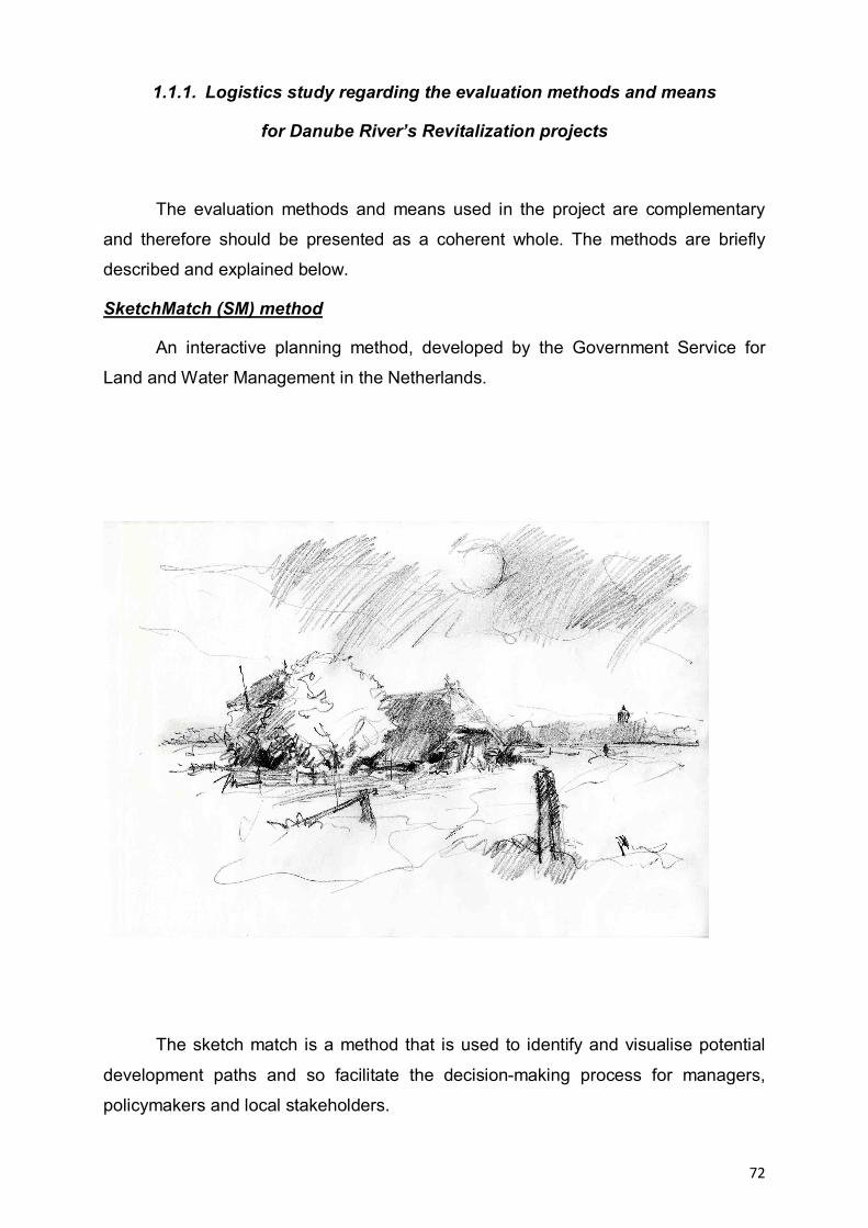
72
1.1.1. Logistics study regarding the evaluation methods and means
for Danube River’s Revitalization projects
The evaluation methods and means used in the project are complementary
and therefore should be presented as a coherent whole. The methods are briefly
described and explained below.
SketchMatch (SM) method
An interactive planning method, developed by the Government Service for
Land and Water Management in the Netherlands.
The sketch match is a method that is used to identify and visualise potential
development paths and so facilitate the decision-making process for managers,
policymakers and local stakeholders.
73
It is an intensive process that organisations and other interested parties can
use in their own development areas.
The SketchMatch is a workshop method and works as a ‘creative pressure
cooker’. During a minimum of 1 to a maximum of 3 days, a group of stakeholders
involved in projects described above come together to analyze, define and find out
the best practices regarding Danube River Revitalisation.
The strength of this method is that these analyses are done collectively.
A SketchMatch is facilitated by a process supervisor and one or more project’s
evaluation specialists, who visualize the status of the projects, problems and
solutions by sketching them out on maps. Various disciplines come together in a
SketchMatch: spatial design, GIS, ecology, hydrology, hydraulics, cost estimation
etc., depending on the nature of the project and issues involved.
Organising a sketch match involves a substantial investment. The working hours that
specialists would usually spend on a project over the course of a longer time period
are now condensed into a few days. Experience has shown that this accelerates the
planning process immediately. It energises the client and the residents of the area
and gives them a sense of community and shared responsibility. A sketch match can
create the momentum a project needs to really take off, or the impetus required to
overcome a deadlock.
However, to have this effect a sketch match must meet a number of conditions
regarding:
a) Definition
The definition must clearly identify the parameters of the problem(s) to be
addressed. In other words: The assignment or problem must be clearly defined.
b) Drafting and visualising
A sketch match is only useful if design and visualisation will genuinely be of
help in identifying potential new development paths and solutions for the issues that
need to be addressed. A sketch match can prove to be useful at any stage of the
planning and implementation process, as long as choices need to be made
concerning spatial planning in a well defined specific area.
74
c) Results
Drafts must always be produced; calculations are optional. Whenever there
are doubts about the financial and economical feasibility of a project the costs of
different solutions can be calculated immediately. The result of a Sketch Match is a
spatial design, in the form of a manual, guideline, map, book, visual story, model, or
whatever form suits the project best.
Focus groups and semi-structured interviews.
There will be organized within each category of subgroups defined by basic
principles of revitalization focus groups. Two researchers must attend every focus
group. Making a larger number of groups allows drafting of behavioral trends for
categories of subjects interviewed.
a) Not all Focus groups are the same. The interviews will not be exactly the same in
each location. It is very important that the results from different locations are
comparable, and the most important thing is to ensure that, however Focus groups
are arranged.
b) The number of partcipants at Focus group. In terms of numbers, the ideal number
is 5-7 participants. Participants in the discussion will have time to make their views
known about Danube River ecological restoration.
c) The Focus groups structures (homogeneous or heterogeneous groups). An
important decision is whether to mix people up in group’s interviews, or have
organized separate groups on the criterion of gender, age. Heterogeneous groups
are useful for hearing differences of opinion, and understanding how conflicts are
negotiated and resolved. However, where there are power differentials between
groups, some people may be afraid to say what they really think.
d) Duration of a interview group. Duration of a interview group shall be determined
according to what should be investigated, and the needs of individuals / institutions
concerned.
e) Instruments used in the Focus groups. In order to make best use analysis, the
investigator shall have different work techniques with applicability to Focus groups.
75
Such tools are:
"time line chart" - a graph versus time, which includes horizontal months / years,
days of the week / month etc. and vertically the seasonal variations of socio-
economic system components.
"mapping" - which involves that the subjects making a systematic maps of the
various aspects covered in the study. In case of refusal, the layout map will be
made by group moderator following the guidelines of the participants.
"games"
In addition to these basic techniques will be group discussions to understand the
thinking of people, how they respond to problems identified. It will follow the
existence of conflicts and consensus, how to resolve conflicts. Before the end of the
discussion will arrange meetings with some participants for semi-structured
individual interviews.
f) The location should be chosen related to the selected projects for the evaluation
of the Danube River revitalization.
Semi-Structured Interviews
The purpose of these interviews is to deepen some interesting issues that
arise during the focus groups.
a) Recruiting people. The ideal place for the selection of subjects for individual
interviews is during the group interview in order to analyze certain aspects relevant to
the discussion group.
b) Location is as important as focus groups. It may use the interviewee for a walk
outside to stimulate him to answer questions.
c) Recording the interview. The researcher’s interviews/observations will be recording
on tape or noted in reseracher’s notes book after the free decision of the subjects
and transcribed and processed for analysis. The interviews will be carried from the
interview guide that explains the main criteria and sub-criteria to be addressed
throughout the interview.
d) Questions. These will vary from one interviewee to another, depending on the
person being discussed and the problems of group interview. Use your local
knowledge to modify and add to this list.

76
Begin the conversation by asking your interviewee a few things about
themselves. Anyway you need to know something about the person for the
information gained in the interview to be useful.
A general point is to be over prepared rather than under prepared. It doesn’t
matter if you do not get around to asking all of the questions. Individual interviews
should be preceded by pilot interviews. It is necessary to record the information
provided by the interviewee and how the interview went, because the methodology
can be improved further. This is done by keeping a permanent contact with the
coordinator, and that results are comparable between different areas of study.
Progressive development of tree problems for the projects for Danube River’s Revitalization
In time, favorability and restrictiveness factors have played an important role in
changing by damage or loss of geographical landscape components in the Danube
River (abiotic, biotic, factors arising from local connection with the natural life, ethnic
identity elements or religious life). Information about existing problems came from a
variety of sources including semi-structured interviews, ethnographic agenda, local
media and specialized literature.
Problem analysis was conducted to create the conceptual model of human
intervention in the geographic landscape of the Danube River, starting from
identifying key factors that have a modifier role and their effect as shown in the
problem tree. Tree problems show the problems in a hierarchical order. First will be
identified causes and effects, then they will be summed and placed in a wider range,
then building the tree as follows:
— what are the causes are at the bottom of the tree;
— what are the effects are at the top of the tree.

77
1.1.2. Classification of Danube River’s Revitalization Project on subclasses
Starting from the projects inventory and the 4 subclasses presented in the
chapter Materials and methods we can conclude that these projects could be
classified according to the standard criterion (Table 1).
No. Crt.
Project name Subclasses
1 The Danube restoration project between Neuburg und Ingolstadt
(Germany)
River restoration
Capture Community Opportunities
2 Bulgarian Wetland Restoration and Pollution Reduction Project
(RIVER ENGINEERING) (Bulgaria) River restoration
3 Extension of the existing Belene Islands Complex Ramsar Site
Bulgaria Create Value
4 The LIFE Project “Upper Drava-river valley” Austria River restoration
Create Value
5 The LIFE Project „Wild river landscape of the Tyrolean Lech”
Austria
River restoration
Create Value
6 Monitoring results of revitalization measures on an urban lowland
River (Liesingbach, Vienna, Austria)
Capture Community Opportunities
7
River Wien restoration project: improvement of the ecological
condition of a heavily modified river in a urban environment
(Austria)
Capture Community Opportunities
8 LIFE Nature Project Wachau of dry grasslands and Danube nase (Austria) River restoration
9 Lobau (Austria): reconnection of floodplains River restoration
10 National Park Donau – Auen (Austria): side arm restoration and river bank restoration
River restoration
11 Morava River (Slovakia and Austria): reconnection of meanders River restoration
12 LIFE05NAT/SK/000112 „Restoration of the Wetlands of Zahorie
Lowland“ (WETREST) Slovakia Create Value
13 Krapje Djol (Croatia): reflooding of oxbow River restoration
14 Camenca river restoration (Moldova) – Lessons learned for river restoration in the eastern part of the Danube River Basin River restoration
78
15 Ecological Restoration in the Danube Delta Biosphere Reserve
(Romania) – Babina and Cernovca islands
Capture Community Opportunities
River restoration
16 Research for ecological restoration in the Dunavat-Dranov region,
Danube Delta (Romania)
Capture Community Opportunities
River restoration
Table 1 – Link between projects and the 4 clases of revitalization
1.2. A PUBLIC DEBATE ABOUT THE DANUBE RIVER’S REVITALIZATION PROJECTS ASSESSMENT
This activity will be accomplished in the next phase and its aim will be to select two projects for each subclasses of Danube revitalization and to formulate strategic guidelines for based on their implementation results.

79
CONCLUSIONS
Along the Danube River, there are planned a lot of restoration and
revitalization project, but in this moment is a lack of ecological restoration projects-
information data base and on Lateral Connectivity and Longitudinal Continuity
finalized projects for this river.
However, restoration ecology is still in its infancy and the literature pertinent to
river restoration is rather fragmented.
(Semi-) aquatic components of floodplains, including secondary channels,
disconnected and temporary waters as well as marshes, have received little
attention, despite their significant contribution to biological diversity.
Many revitalization projects were planned or realized without prior knowledge
of their potential for success or failure, although, these projects greatly contributed to
our present understanding of river-floodplain systems.
River revitalization benefits from a consideration of river ecosystem concepts
in quantitative terms, comparison with reference conditions, historical or others, and
the establishment of interdisciplinary partnerships.
Despite the benefits of ecological concepts for understanding large rivers, like
Danube River, more multidisciplinary empirical studies are needed to asses the
ecological state of river-floodplain systems, so as to facilitate restoration planning
and challenge existing conceptual constructs.
Information on habitat diversity, biological production and the source and flow
of energy is especially important.
Other important issues that need to be resolved include the questions of
whether hydro- and morpho-dynamics should be increased or decreased, and to
what extent floodplain succession can be reset by integrating conflicting interests of
ecological needs, safety and navigation.
From the inventory of projects regarding Danube River revitalization can be
seen that certain projects are at the interference of several fundamental principles of
revitalization.
Majority of research studies are on Water Directive Framework thematic,
Flood Risk Management Directive and Natura 2000.
80
From the total number of 16 projects identified, 10 of them are on river
restoration, especially in Austria and in the Danube Delta area.
The projects done in order to create socio-economical values are those for
tourism.
The Danube River restoration must focus on the dynamic interplay among the
main channel, the floodplain, and the tributaries.
Successful Danube River and wetland restoration demands an
interdisciplinary approach in order to understand how the Danube River and Danube
floodplain system function.
81
BIBLIOGRAPHY
1. Binder W., (2008), River restoration: an European overview on rivers in urban
areas. In ECRR Conference on River Restoration, vol. 4th, Editor Gumiero B.,
Rinaldi M., Fokkens B., pg. 95-100, Italy, Venice S. Servolo Island
2. Buijse A. D. et al., (2002), Restoration strategies for river floodplains along
large lowland rivers in Europe, In Freshwater Biology Journal, vol. 47th, Editor Hildrew Alan G. and Townsend Colin R., pg. 889-907
3. Drost H.J., Bos D., Tudor M., (2002), Research for ecological restoration in the
Dunavat-Dranov region, Danube Delta, Editor Altenburg & Wymenga
ecological consultants / RIZA Lelystad
4. Drumea D., Tarigradschi V., (2008), Camenca river resoration – lesson
learned for river restoration in the eastern part of the Danube River Basin. In
ECRR Conference on River Restoration, vol. 4th, Editor Gumiero B., Rinaldi
M., Fokkens B., pg. 301-305, Italy, Venice S. Servolo Island
5. Georgeta Marin, Erika Schneider, (1997), Ecological restoration in the Danube
Delta Biosphere Reserve/Romania. Babina and Cernovca islands, Editor
ICPDD/Umweltstiftung WWF-Deutschland
6. Holubova K., Hey R. D. & Lisicky M. J. (2003), Middle Danube tributaries:
constraints and opportunities in lowland, In Lowland River Rehabilitation “ An
international conference addressing the opportunities and constraints, costs
and benefits to rehabilitate natural dynamics, landscapes and biodiversity in
large regulated lowlands rivers”, vol. 22, Editor Buijse A. D., Leuven R. S. E.
W., Greijdanus-Klaas M., pg. 38
7. Iversen T. M., Menke U. & Andersen J. M., (2003), Restoration of large
European lowland rivers: past and future, In Lowland River Rehabilitation “ An
international conference addressing the opportunities and constraints, costs
and benefits to rehabilitate natural dynamics, landscapes and biodiversity in
large regulated lowlands rivers”, vol. 22, Editor Buijse A. D., Leuven R. S. E.
W., Greijdanus-Klaas M., pg. 17
8. Keckeis H., Fesl C., Hoyer H., Schludermann E., Scheder C., Forster R.,
Katzmann M., (2008), River Wien restauration project: improvement of the

82
ecological conditions of a heavily modified river in a urban environment. In
ECRR Conference on River Restoration, vol. 4th, Editor Gumiero B., Rinaldi
M., Fokkens B., pg. 571-582, Italy, Venice S. Servolo Island
9. Panek K., Korner I., Lang H., Markut T., Petz R., Petz W., Siegl W., Monitoring
results of revitalization measures on a urban lowland river (Liesingbach,
Vienna, Austria). In ECRR Conference on River Restoration, vol. 4th, Editor
Gumiero B., Rinaldi M., Fokkens B., pg. 837-846, Italy, Venice S. Servolo
Island
10. Sommerwerk N., Bloesch J., Paunovic M., Baumgartner C. Venohr M.,
Schneider-Jacoby M., Hein T. and Tockner K., (2010), Managing the world’s
most international river: the Danube River Basin, In CSIRO; Journal:MF:
Marine and Freshwater Research, pg. 1-37
11. Stammel B., Cyffka B., Haas F., Schwab A., Restoration of river/floodplain
interconnection and riparian habitats along the embanked Danube between
Neuburg and Ingolstadt. In ECRR Conference on River Restoration, vol. 4th,
Editor Gumiero B., Rinaldi M., Fokkens B., pg. 129-138, Italy, Venice S.
Servolo Island
12. * * * (1999), Evaluation of wetlands and floodplain areas in Danube River
Basin, WWF DANUBE- CARPATHIAN-PROGRAMME and WWF-AUEN-
INSTITUT (WWF GERMANY)
Internet sources:
www.broz.sk
www.biomura.si
http://bulgarsko.eu/ovm.php?l=en&pageNum_Ovm_All=0&totalRows_Ovm_All=113&
id=17
http://siteresources.worldbank.org/BULGARIAEXTN/Resources/WetlandsBroshure6.
http://www.icpdr.org/icpdr-pages/dw0803_p_06.htm
http://forecaster.ontwikkel.gisinternet.nl/index.php?title=Description
www.life-wachau.at
www.lariverrmp.org
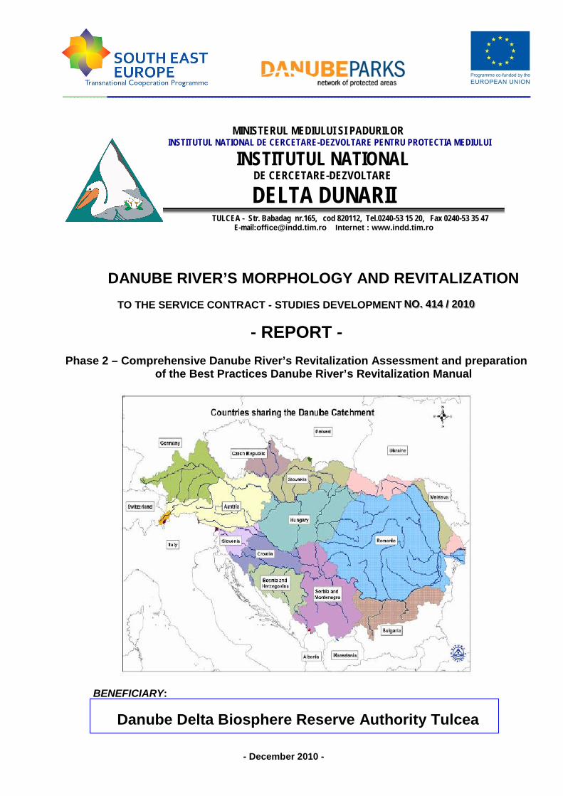
MINISTERUL MEDIULUI SI PADURILORINSTITUTUL NATIONAL DE CERCETARE-DEZVOLTARE PENTRU PROTECTIA MEDIULUI
INSTITUTUL NATIONALDE CERCETARE-DEZVOLTARE
DELTA DUNARIITULCEA - Str. Babadag nr.165, cod 820112, Tel.0240-53 15 20, Fax 0240-53 35 47
E-mail:[email protected] Internet : www.indd.tim.ro
DANUBE RIVER’S MORPHOLOGY AND REVITALIZATIONTO THE SERVICE CONTRACT - STUDIES DEVELOPMENT NNNOOO... 444111444 /// 222000111000
- REPORT -Phase 2 – Comprehensive Danube River’s Revitalization Assessment and preparation
of the Best Practices Danube River’s Revitalization Manual
BENEFICIARY:
Danube Delta Biosphere Reserve Authority Tulcea
- December 2010 -
2
MINISTERUL MEDIULUI SI PADURILORINSTITUTUL NATIONAL DE CERCETARE-DEZVOLTARE PENTRU PROTECTIA MEDIULUI
INSTITUTUL NATIONALDE CERCETARE-DEZVOLTARE
DELTA DUNARIITULCEA - Str. Babadag nr.165, cod 820112, Tel.0240-53 15 20, Fax 0240-53 35 47
E-mail:[email protected] Internet : www.indd.tim.ro
THE SERVICE CONTRACT - STUDIES DEVELOPMENT NNNOOO... 444111444 /// 222000111000
STUDY NAME :
DANUBE RIVER’S MORPHOLOGY AND REVITALIZATION
PROGRAMME NAME:
TRANSNATIONAL COOPERATION PROGRAMME FOR SOUTH-EAST EUROPE 2007-2013
PROJECT NAME:
DANUBEPARKS - DANUBE RIVER NETWORK OF PROTECTED AREAS -DEVELOPMENT AND IMPLEMENT THE TRANSNATIONAL STRATEGIES FORCONSERVATION OF DANUBE NATURAL HERITAGE
- REPORT –Phase 2 - Comprehensive Danube River’s Revitalization Assessment and preparation of
the Best Practices Danube River’s Revitalization Manual
BENEFICIARY :
DANUBE DELTA BIOSPHERE RESERVE AUTHORITY TULCEA
PERFORMER:
DANUBE DELTA NATIONAL INSTITUTE FOR RESEARCH AND DEVELOPMENT
General Director DDNI Tulcea Eng. Romulus ŞTIUCĂ
Scientific Director DDNI Tulcea Dr. Eng. Mircea STARAŞ
Project Coordinator DDNI Tulcea Dr. Eng. Iulian NICHERSU
- DECEMBER 2010 -
TULCEA

3
WORK TEAM
DANUBE DELTA NATIONAL INSTITUTE FOR RESEARCH ANDDEVELOPMENT :
- Dr. Eng. IULIAN NICHERSU – project manager
- EUGENIA MARIN – socio-ecology
- MARIAN MIERLĂ - hydro-geo-morphology
- FLORENTINA SELA - socio-ecology
- CRISTIAN TRIFANOV – hydro-geo-morphology
- IULIANA NICHERSU – spatial planning
- ADRIAN CONSTANTINESCU - hydro-geo-morphology
- JENICA HANGANU – ecological restoration
- VASILE OTEL – biodiversity
4
T A B L E O F C O N T E N T S:
Pg.
INTRODUCTION.......................................................................................................5
MATERIALS AND METHODS..................................................................................................5
RESULTS OF THIS PHASE…………….…………………………………………...…..6
Activity 2.1. Conceptual Framework and Danube River’s Revitalization Analysis
Methods……………………………………………………….…………………………...…6
Activity 2.2. Analysis Functional Multicriterial Model………………………………14
Activity 2.3. Aggregate indicators to economic and ecological evaluation..…..18
CONCLUSIONS……………..……………………………………………………………33
BIBLIOGRAPHY…………….….….…………………………………………………….…….. 36
5
Phase 2 - Comprehensive Danube River’s Revitalization Assessment andpreparation of the Best Practices Danube River’s Revitalization Manual.
Introduction
As a very long-term goal, its ecological and hydrological functioning can berestored through creation of a continuous riparian habitat corridor within hydronetwork of arms and channels and through removal of concrete walls where feasible.While completely restoring the Danube Valley to a naturalized conditions is not likelyfeasible, the restoration projects address to flood control requirements and riverchannel could be naturalized in significant areas.
Three goals complement the efforts to restore river functioning ecosystems:
- enhance flood storage - focuses on off- channel storage of peak floods flows inorder to reduce flow velocities, which is a necessary precondition for ecosystemrestoration;- enhance water quality - seeks to improve the quality of water withinimplementation of a comprehensive, landscape-based system for filtering;- restore the ecosystems functions - aims to restore the natural ecosystemsaffected by human activity and restoration of these ecosystems function.
Materials and Methods
To accomplish this phase Comprehensive Danube River’s RevitalizationAssessment and preparation of the Best Practices Danube River’s RevitalizationManual the following activities were achieved through different approaches:
Within this activity the documentation was made from various sources of information:
Scientific literature - books, articles and other scientific publications (e.g. Binder
W., (2008), River restoration: an European overview on rivers in urban areas. In
ECRR Conference on River Restoration; Buijse A. D. et al., (2002), Restoration
strategies for river floodplains along large lowland rivers in Europe, In
Freshwater Biology Journal; Drost H.J. et al., (2002), Research for ecological
restoration in the Dunavat-Dranov region, Danube Delta; Holubova K. et al.,
(2003), Middle Danube tributaries: constraints and opportunities in lowland, In
Lowland River Rehabilitation “An international conference addressing the
opportunities and constraints, costs and benefits to rehabilitate natural
dynamics, landscapes and biodiversity in large regulated lowlands rivers”);
Official Web sites of natural parks along the Danube bodies involved and
intenational (ECRR, WWF etc.)

6
FORECASTER project (http://forecaster.deltares.nl/index.php?title=Main_Page)
In this activity was developed a conceptual framework and a matrix of criteria forrestoration projects assessments.
RESULTS OF THIS PHASE
Activity 2.1. Conceptual Framework and Danube River’s Revitalization AnalysisMethods
Background & definitions
There had been developed and applied at the Danube hydrographical basinscale, especially in the second part of the XX century, a lot of management plans andpolicies which were grounded exclusively on neoclassical economy principles. Theseprinciples had a large class of economical and social objectives from which somewere identified as driven forces for Lower Danube wetlands System structural andfunctional changes, such as:
1. economical objective translated as arable surface extension and increaseagricultural production;
2. urban and industrial development;3. Danube River and its main tributaries hydro-electrical potential
capitalization and protection against floods;4. to counteract the drought effects toward agriculture crops;5. to maintain and develop the navigation conditions and infrastructure.Achieving these strategic and political objectives required the development
and implementation of management plans and programs, each consisting of a widerange of human activities and that means to exercise pressure on the Lower DanubeFloodplain.
As is well known, the productivity and stability of ecosystems depends directlyon their viability, to provide physical support for the use of natural resources and toprovide socio-economic system services. Analysis of ecosystems as dynamicsystems, nonlinear and as production units consists in lengthy processes of whichvariability and diversity are essential for unit stability and productivity. This analysisdoes not overlook the social and economic implications, taking into account therelationship between Natural Assets of the unit and the existing Socio-EconomicSystem, following the same principles.
For a coherent understanding and interpretation due to the spatio-temporaldynamics of interactions complexity between human population and environment it isneeded to tackle by a theoretical transdisciplinary integrating model framework thatallows changes, transformations, trends and adjustments identification/understanding in the system.
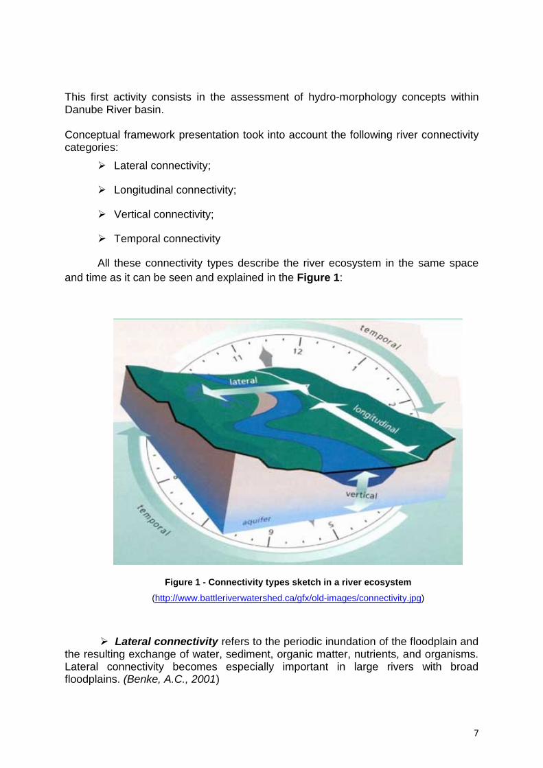
7
This first activity consists in the assessment of hydro-morphology concepts withinDanube River basin.
Conceptual framework presentation took into account the following river connectivitycategories:
Lateral connectivity;
Longitudinal connectivity;
Vertical connectivity;
Temporal connectivity
All these connectivity types describe the river ecosystem in the same spaceand time as it can be seen and explained in the Figure 1:
Figure 1 - Connectivity types sketch in a river ecosystem
(http://www.battleriverwatershed.ca/gfx/old-images/connectivity.jpg)
Lateral connectivity refers to the periodic inundation of the floodplain andthe resulting exchange of water, sediment, organic matter, nutrients, and organisms.Lateral connectivity becomes especially important in large rivers with broadfloodplains. (Benke, A.C., 2001)
8
To discuss about the lateral connectivity it is good to have some question atthe beginning and to try to find some answers as an understanding way of theconcept.
Is the river able to connect with its floodplain (during floods etc.)?
In a natural status the river keep connection with its floodplain especially infloods time, invading places with its water, new sediments and all its influence.Former streams become active, small pools are filled up with fresh water; parts of theground are covered by new sediments.
Is there a connection between the aquatic and terrestrial (upland)environments?
In main cases there is a connection between the aquatic and terrestrialenvironments by the simple fact that they lay side by side and the water through thecapillarity of the soil ensures a certain degree of moisture that influence the presenceof specific vegetation and animals.
Is there a healthy riparian area?
Riparian area is the interface between land and a river or stream. A healthyecosystem is an ecosystem in which structure and functions allow the maintenanceof biodiversity, biotic integrity and ecological processes over time. The lateralconnectivity is a premise of a healthy riparian biome.
Longitudinal connectivity refers to the pathways along the entire lengthof a stream. As the physical gradient changes from source to mouth, chemicalsystems and biological communities shift and change in response. The RiverContinuum Concept (RCC) can be applied to this linear cycling of nutrients,continuum of habitats, influx of organic materials, and dissipation of energy.(Watershed Assessment Tool: Connectivity Concepts – Minnesota Department ofNatural Resources)For example:
A headwater woodland stream has steep gradient with riffles, rapids and falls; Sunlight is limited by overhanging trees, so photosynthesis is limited; Energy comes instead from leaves and woody material falling into the stream; Aquatic insects break down and digest the terrestrial organic matter; Water is cooled by springs and often supports trout.
In the mid-reaches the gradient decreases and there are fewer rapids and falls; the stream is wider; sunlight reaches the water allowing growth of aquaticplants; insects feed on algae and living plants; proportion of groundwater to runoff is lower so stream temperatures arewarmer; the larger stream supports a greater diversity of invertebrates and fish.
9
The river grows and the gradient lessens with few riffles and rapids
Terrestrial organic matter is insignificant in comparison to the volume of water; Energy is supplied by dissolved organic material from upstream reaches; Drifting phytoplankton and zooplankton contribute to the food base as do organicmatter from the floodplain during flood pulses; Increasing turbidity reduces sunlight to the streambed causing a reduction inrooted aquatic plants; Backwaters may exist where turbidity has settled and aquatic plants areabundant; Fish species are omnivores and plankton feeders such as carp, buffalo, suckers,and paddlefish; Sight feeders are limited due to the turbidity (MN DNR, Healthy Rivers).
To discuss about the longitudinal connectivity it is good to have some questionat the beginning and to try to find some answers as an understanding way of theconcept.
How connected is the river along its length?
The longitudinal connectivity implies that stream (in our case river) shouldhave a continuously path from the spring to its mouth. This is the natural case.
Is it broken up by dams, weirs or natural obstacles?
This longitudinal continuity could be often tainted by natural and artificialcauses. The main artificial causes are: dams for different purposes (water stocking,producing energy etc.). Natural causes are more rare and usually are accidentally(weirs created by thunderstorms by getting down the trees) and not accidentallyweirs created by beavers.
Vertical connectivity is represented by the connection between theatmosphere and groundwater. The ability of water to cycle through soil, river, and airas liquid, vapor, or ice is important in storing and replenishing water (Figure 2). Thisexchange is usually visualized as unidirectional–precipitation falling onto land andthen flowing over land or percolating through the ground to the stream. An equallyimportant transfer of water occurs from the streambed itself to surrounding aquifers.Groundwater can contribute to flows in the river at certain times in the year and atcertain locations on the same stream. Streams may either gain or lose water to thesurrounding aquifer depending on their relative elevations. Lowering the water tablethrough groundwater withdrawals may change this dynamic exchange inunanticipated ways (Stream Corridor, FISRWG).
The slow movement of water through sediments to the river produces severalecological benefits (Minnesota Department of Natural Resources):

10
The water is filtered of many impurities. It usually picks up dissolved minerals. The water is cooled.
The water is metered out slowly over time.
This is particularly important in smaller, cooler streams for the maintenance ofcritical habitat for fish, wildlife and invertebrate species.
Figure 2 – Vertical connectivity sketch in a river ecosystem (Stream Corridor, FISRWG)
Temporal connectivity consists in continuous physical, chemical, andbiological interactions over time, according to a rather predictable pattern. Thesepatterns and continuity are important to the functioning of the ecosystem. Over time,sediment shifts, meanders form, bends erode, oxbows break off from the mainchannel, channels shift and braid. A stream rises and falls according to seasonalpatterns, depending on rain and snowmelt. Throughout most of Minnesota, free-flowing rivers experience high water in spring, falling flows in summer, moderateflows in fall, and base flows in winter. The watershed has adjusted to these normalfluctuations, and many organisms have evolved to depend on them (MN DNR,Healthy Rivers).
11
The importance of the connectivity
Connectivity is important because it ensures natural river processes continueto occur (channel maintenance, floodplain evolution).
It is also important because isolated (fragmented) habitats, whether aquatic orterrestrial, have fewer species (biodiversity), and it is difficult for species to re-colonize isolated habitats.
Connectivity also ensures there is a flow of energy and nutrients between andwithin aquatic and terrestrial (land) environments. For example, in the fall, leaves arewashed into the river and provide important food for aquatic insects.
The connectivity of the river ensures also the ecosystems services. Theecosystem services are as follows (by the Millenium Ecosystem Assessmentclassification):
Provisioning services, the products obtained from ecosystems, including, forexample, genetic resources, food and fiber, and fresh water.
Regulating services, the benefits obtained from the regulation of ecosystemprocesses, including, for example, the regulation of climate, water, and somehuman diseases.
Supporting services, that are necessary for the production of all otherecosystem services. Some examples include biomass production, productionof atmospheric oxygen, soil formation and retention, nutrient cycling, watercycling, and provisioning of habitat.
Cultural services, the non-material benefits people obtain from ecosystemsthrough spiritual enrichment, cognitive development, reflection, recreation, andaesthetic experience as well as knowledge systems, social relations, andaesthetic values.
Connectivity is crucial in the context of restoration. Many reach-scalerestoration projects have been unsuccessful because they were conceived andimplemented in isolation from the larger catchment context (Frissell and Nawa 1992,Muhar 1996, Wohl et al. 2005 cited by Mathias Kondolf et all). For example, instreamstructures used in some restoration projects have not been recolonized because of alimited pool of potential colonizers in nearby intact sites or because of barriers todispersal of the colonizers (Bond and Lake 2003). Alternatively, the structure may beoverwhelmed by sediment derived from upstream sources and carried downstreamthrough the drainage network (Iversen et al. 1991).(http://www.ecologyandsociety.org/vol11/iss2/art5/)
12
Logical Framework Analyse for Danube River Morphology and Restoration
Restoration framework
The following steps were established for each restoration project to befallowed, in order to have a good perception of the assessment:
Step 1 – Identifying Problems and OpportunitiesThe problem, or perceived degradation of ecosystem properties and
reduction in related resources, must first be clearly stated. The first place to considerrestoration and uncertainty is in the selection of planning objectives. Planningobjectives give a rational focus to the planning process. Optimal objectives forrestoration projects will reflect a watershed, or other ecosystem perspective.• Step 2 – Inventory and Forecast
• Step 3 - Ecological Restoration Plan Formulation - Management measures
- System Context
- Conceptual and Empirical Models
- Landscape Variables identified through several indicators as:
a) the land segregation indicator that measures the aquatic and agricultureavailability related to the total number of people, being the expression of the abovemathematical formula Ils=AG/P-A/P, where lls is the land segregation indicator, theAG is the agricultural land use, P is the local population within the restored area andA is the aquatic area. The knowledge of this indicators has triple role: as mark forquantifying the agriculture an and aquatic potential, unit measure for the correlationdegree between these land categories, support for the decision processes andstakeholders in terms of applying legislative measures in the restores areas;
b) the environmental indicator is given by the ration between the wooded area andthe agriculture and artificial land;
c) the agriculture productivity indicator represents the ration between an output(effect) and input (effort), expressing the efficiency in using the production factors.
- Implications for Plan Formulation
- Uncertainties Associated with the Models used for Management which mustrespond to following questions:
Will there be adequate ecological corridors?
How will restoration for a species affect the community?
Is the site large enough?
How will the project’s resistance and resilience change over time? Is this acceptable?
What are the likely landscape changes over time? How will they affect the site?

13
Does the design invite invasive species?
How will the community affect the species of interest?
What else could go wrong?
• Step 4 – Evaluation of Project Solutions
• Step 5 – Comparation of Alternatives
• Step 6 – Ecological Restoration Plan Selection
Criteria and General Model for Ecosystem PerformanceThe general model for ecosystem performance (Figure 3) provides the
general direction with respect to structure and function that the ecosystem isexpected to take on its trajectory toward meeting the project goal. Under a restorationscenario, the goal is to move the system from a degraded condition to one that isless degraded and more desirable. For management purposes, it is assumed thatthere is a positive relationship between the structure and function of an ecosystem.The natural structure of an system, habitat, or community has a correspondingfunctional condition, and to the extent that this is predictable, this information may beused to construct the ecosystem performance model
Figure 3 - General model of ecosystem performance. An ecosystem or habitat thatis in rudimentary condition with low functioning develops into a system with optimalstructure and functioning. Development can take several pathways, and can oscillate
between system states (Thom R.M, 2004).
Figure 3 also indicates that a system may oscillate between states. Thiscan be caused by stochastic processes such as human or natural disturbances, aswell as stochastic climate related forcing. This dynamic may be more pronounced insome system types than in others. It is important to recognize that the system canmove between different structural and functional states and still maintain its long-termintegrity. Finally, and not explicit in Figure 3, is the fact that stability regimes arerarely ecosystem-wide, but are limited to some fraction of the ecosystem.
14
This implies that if enough of an ecosystem is restored, sites within thatsystem should support desirable resources.
If stressors are removed, the natural recovery (passive restoration) ofecosystems will tend to take place regardless of human intervention, but this maytake a very long time— decades or centuries. Active restoration essentially meansthat humans act beyond stress removal to reduce the period of time required toimprove ecosystem conditions, through a combination of physical intervention andnatural recovery. At the desirable ecosystem condition, the system is fully functional,has an optimal structure, is resilient to disturbances, and is self-maintaining.However, the definition of “optimal” must be made with care and with relevance to thesystem under investigation. In the case presented here, it is assumed that optimalconditions are met with a natural climax community that, because of its persistence,is resistant and maintains itself through the ability to buffer changes. The term“optimal” implies a human value, and the optimal state represents what humans (i.e.,restoration planners) view as the “best” condition for the system.
Activity 2.2. Analysis Functional Multicriterial Model
Within this activity was developed a matrix of multicriterial indicatorsgrouped on 4 main assessment criteria as follows: Stakeholder success, Ecologicalsuccess, Learning success, River system. Each indicator must receive a valuebetween 1 and 5 corresponding to success level achieved by each restorationproject: value 1 represents the most unsuccessful result and value 5 is given to themost successful result.
Stakeholder success reflects human satisfaction with restoration outcome, whereaslearning success reflects advances in scientific knowledge and managementpractices that will benefit future restoration action.
Ecological success1. Guiding image exists evaluation standards should follow the principles below:1. Ecological integrity. Because of strong interference from human activities, it is notpossible to restore urban water ecosystems to the pristine state. Ecologicalrestoration should be based on achieving the greatest natural state for the specificregion, in reference to its natural state, with the relative ecological integrity as thetarget. The health of the ecosystem may not be the original ecosystem, but it must bea relatively complete ecosystem.2. Management categories. In this paper, the evaluation standard is divided into 3levels ‘‘healthy, critical state, unhealthy’’.3. Objective integrity. Danube River Valley is a complex of ecosystems, and shouldmeet the flood control objectives, landscape function, and achieve a harmoniouswater–human relationship.4. Spatial distribution. Within the context of integrated river basin ecosystem theory,the evaluation of the ecological restoration sites should consider the characteristicsof the different spatial components and the differences of environmental problems ineach area, including differences between upstream and downstream locations anddifferent ecosystem service function.2. Ecological improvement. Ecologically successful restoration will inducemeasurable changes in physicochemical and biological components of the targetriver or stream that move towards the agreed upon guiding image.
15
3. Self sustainingThe ecosystem is self-sustaining. It has the potential to persist indefinitely underexisting environmental conditions. Aspects of its biodiversity, structure andfunctioning will change as part of normal ecosystem development, and may fluctuatein response to normal periodic stress and occasional disturbance events of greaterconsequence. As in any intact ecosystem, the species composition and otherattributes of a restored ecosystem may evolve as environmental conditions change.Ecologically successful river restoration creates hydrological, geomorphologic andecological conditions that allow the restored river to be a resilient self-sustainablesystem, one that has the capacity for recovery from rapid change and stress (Holling1973; Walker et al . 2002, cited by Palmer, 2005). Natural river ecosystems are bothself-sustaining and dynamic, with large variability resulting from natural disturbances.4. No lasting harm is doneIn the last century, Aldo Leopold (1948) , cited by Palmer, 2005, stated that the first‘rule’ of restoration should be to do no harm. Restoration is an intervention thatcauses impacts to the system, which may be extreme (e.g. channel reconfigurations).Even in such situations, an ecologically successful restoration minimizes the long-term impacts to the river. For example, a channel modification project shouldminimize loss of native vegetation during in river reconstruction activity, and shouldavoid the fish-spawning season for construction work. Indeed, removal of any nativeriparian vegetation should be avoided unless absolutely necessary. Additionally,restoration should be planned so that it does not degrade other restoration activitiesbeing carried out in the vicinity (e.g. by leading to permanent increases in thedownstream transport of sediments that are outside the historical range of sedimentflux).5. Ecological assessment is completed- pre and post project assessment isconducted and the information made availableEcological success in a restoration project cannot be declared in the absence of clearproject objectives from the start and subsequent evaluation of their achievement(Dahm et al . 1995). Both positive and negative outcomes of projects must be sharedregionally, nationally and internationally (Nienhuis & Gulati 2002, cited by Palmer,2005).
Learning successThe circumstances that we seek to address are often very challenging. The areas ofdegraded land now present in various parts of the world are large. Some systems areseverely degraded and will be costly to repair. Further, people are still using many ofthese degraded systems and many of these people are poor. We may not succeed infully eradicating the causes of degradation in these circumstances but there issufficient evidence from a variety of case studies for us to be optimistic. Thisevidence makes it clear that ecological restoration will be a key element not only ofconservation but also for sustainable development worldwide.
River system it is about the river connectivity (lateral, longitudinal & temporal).
Further more, the assessment criteria matrix developed in this activity wasapplied as an example (for Babina and Cernovca well known restoration projects) toillustrate its benefits (Table 1).
The next steps will focus on applying this matrix to each project identifiedwithin DanubeParks project, as shown in Table 2.
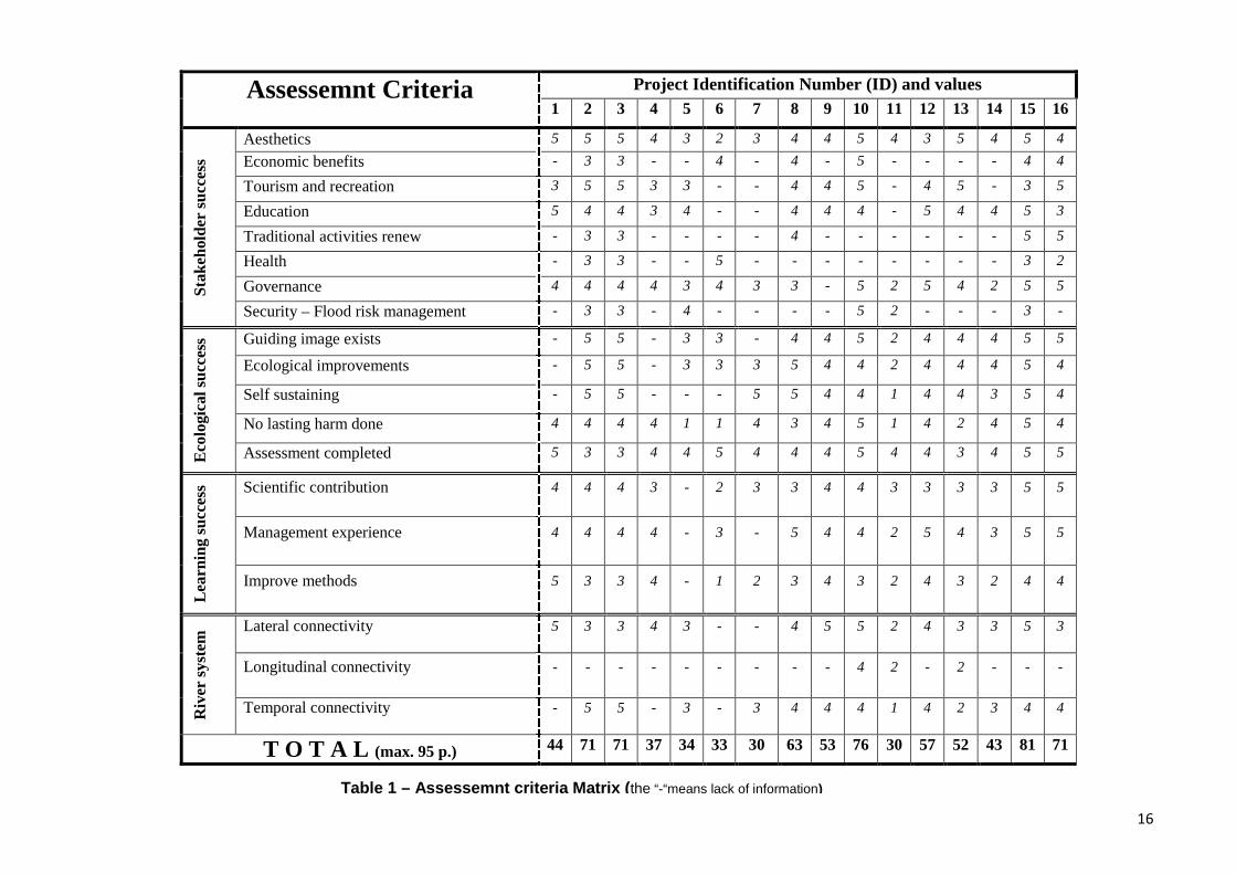
16
Project Identification Number (ID) and valuesAssessemnt Criteria1 2 3 4 5 6 7 8 9 10 11 12 13 14 15 16
Aesthetics 5 5 5 4 3 2 3 4 4 5 4 3 5 4 5 4
Economic benefits - 3 3 - - 4 - 4 - 5 - - - - 4 4
Tourism and recreation 3 5 5 3 3 - - 4 4 5 - 4 5 - 3 5
Education 5 4 4 3 4 - - 4 4 4 - 5 4 4 5 3
Traditional activities renew - 3 3 - - - - 4 - - - - - - 5 5
Health - 3 3 - - 5 - - - - - - - - 3 2
Governance 4 4 4 4 3 4 3 3 - 5 2 5 4 2 5 5Stak
ehol
der
succ
ess
Security – Flood risk management - 3 3 - 4 - - - - 5 2 - - - 3 -
Guiding image exists - 5 5 - 3 3 - 4 4 5 2 4 4 4 5 5
Ecological improvements - 5 5 - 3 3 3 5 4 4 2 4 4 4 5 4
Self sustaining - 5 5 - - - 5 5 4 4 1 4 4 3 5 4
No lasting harm done 4 4 4 4 1 1 4 3 4 5 1 4 2 4 5 4
Eco
logi
cal s
ucce
ss
Assessment completed 5 3 3 4 4 5 4 4 4 5 4 4 3 4 5 5
Scientific contribution 4 4 4 3 - 2 3 3 4 4 3 3 3 3 5 5
Management experience 4 4 4 4 - 3 - 5 4 4 2 5 4 3 5 5
Lea
rnin
g su
cces
s
Improve methods 5 3 3 4 - 1 2 3 4 3 2 4 3 2 4 4
Lateral connectivity 5 3 3 4 3 - - 4 5 5 2 4 3 3 5 3
Longitudinal connectivity - - - - - - - - - 4 2 - 2 - - -
Riv
er s
yste
m
Temporal connectivity - 5 5 - 3 - 3 4 4 4 1 4 2 3 4 4
T O T A L (max. 95 p.) 44 71 71 37 34 33 30 63 53 76 30 57 52 43 81 71
Table 1 – Assessemnt criteria Matrix (the “-“means lack of information)
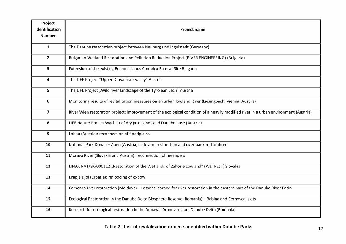
17
ProjectIdentification
NumberProject name
1 The Danube restoration project between Neuburg und Ingolstadt (Germany)
2 Bulgarian Wetland Restoration and Pollution Reduction Project (RIVER ENGINEERING) (Bulgaria)
3 Extension of the existing Belene Islands Complex Ramsar Site Bulgaria
4 The LIFE Project “Upper Drava-river valley” Austria
5 The LIFE Project „Wild river landscape of the Tyrolean Lech” Austria
6 Monitoring results of revitalization measures on an urban lowland River (Liesingbach, Vienna, Austria)
7 River Wien restoration project: improvement of the ecological condition of a heavily modified river in a urban environment (Austria)
8 LIFE Nature Project Wachau of dry grasslands and Danube nase (Austria)
9 Lobau (Austria): reconnection of floodplains
10 National Park Donau – Auen (Austria): side arm restoration and river bank restoration
11 Morava River (Slovakia and Austria): reconnection of meanders
12 LIFE05NAT/SK/000112 „Restoration of the Wetlands of Zahorie Lowland“ (WETREST) Slovakia
13 Krapje Djol (Croatia): reflooding of oxbow
14 Camenca river restoration (Moldova) – Lessons learned for river restoration in the eastern part of the Danube River Basin
15 Ecological Restoration in the Danube Delta Biosphere Reserve (Romania) – Babina and Cernovca Islets
16 Research for ecological restoration in the Dunavat-Dranov region, Danube Delta (Romania)
Table 2– List of revitalisation projects identified within Danube Parks
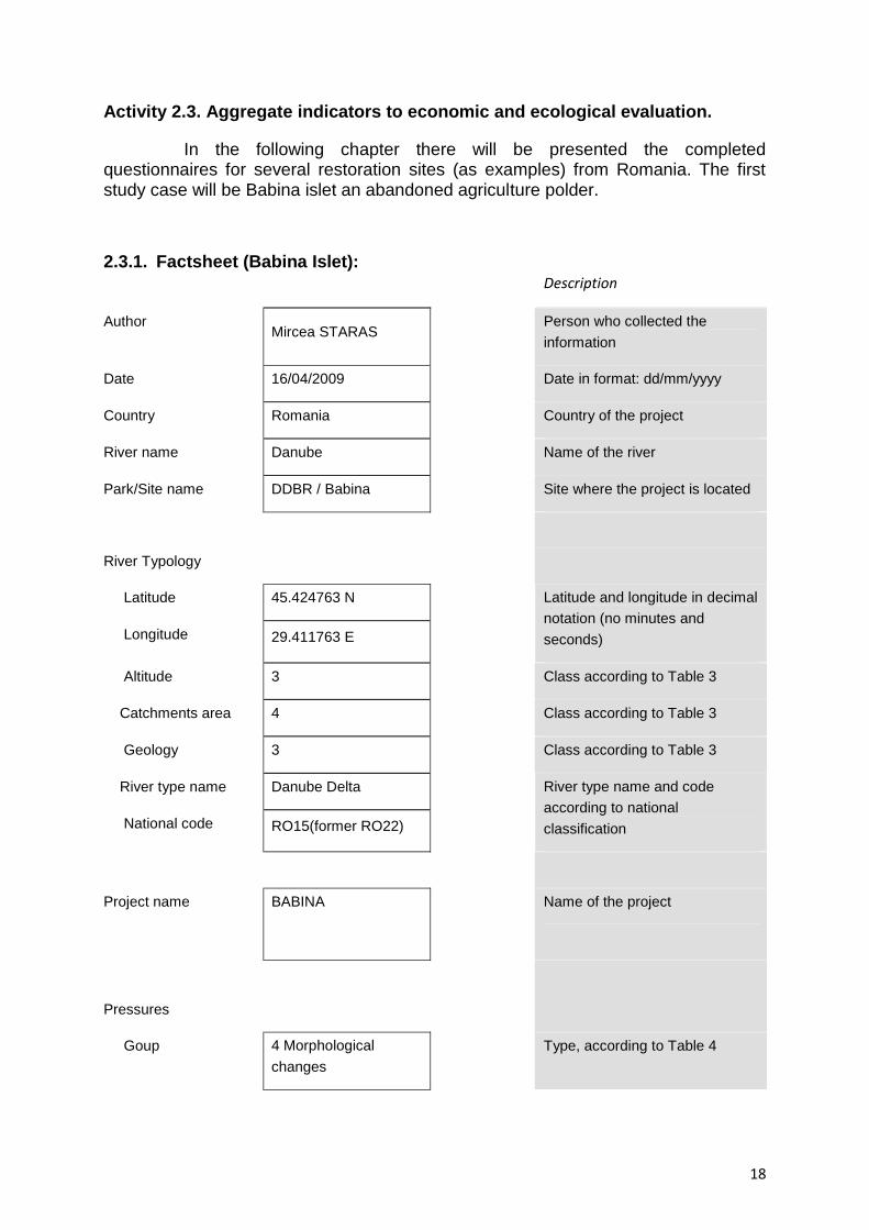
18
Activity 2.3. Aggregate indicators to economic and ecological evaluation.
In the following chapter there will be presented the completedquestionnaires for several restoration sites (as examples) from Romania. The firststudy case will be Babina islet an abandoned agriculture polder.
2.3.1. Factsheet (Babina Islet):Description
AuthorMircea STARAS
Person who collected theinformation
Date 16/04/2009 Date in format: dd/mm/yyyy
Country Romania Country of the project
River name Danube Name of the river
Park/Site name DDBR / Babina Site where the project is located
River Typology
Latitude 45.424763 N
Longitude 29.411763 E
Latitude and longitude in decimalnotation (no minutes andseconds)
Altitude 3 Class according to Table 3
Catchments area 4 Class according to Table 3
Geology 3 Class according to Table 3
River type name Danube Delta
National code RO15(former RO22)
River type name and codeaccording to nationalclassification
Project name BABINA Name of the project
Pressures
Goup 4 Morphologicalchanges
Type, according to Table 4

19
Type 4.6 Embankments
Description Drained wetland foragriculture use (rice)
Particular description
Measures
Group 7 Improving the lateralconnectivity
Group according to Table 5
Measure7.2 Set backembankments, leveesor dykes
According to Table 5
Description Dyke breaches Particular description
Project size 2100 Units Ha Area covered by the project
Approximate cost 840.000 Units Euro Approximate cost of the project
Synergy Nutrients retention,wild life habitat
Combination of the project with
other functions (e.g. flood
protection, navigation)
Status Finalized Planned, in progress or finished
Period of realization 1994 Approximate dates
Evaluation YES Yes or No
Implemented by Danube Delta NationalInstitute for Researchand Development(DDNI)
Name of organization who
implemented the works
(from Forecaster project)
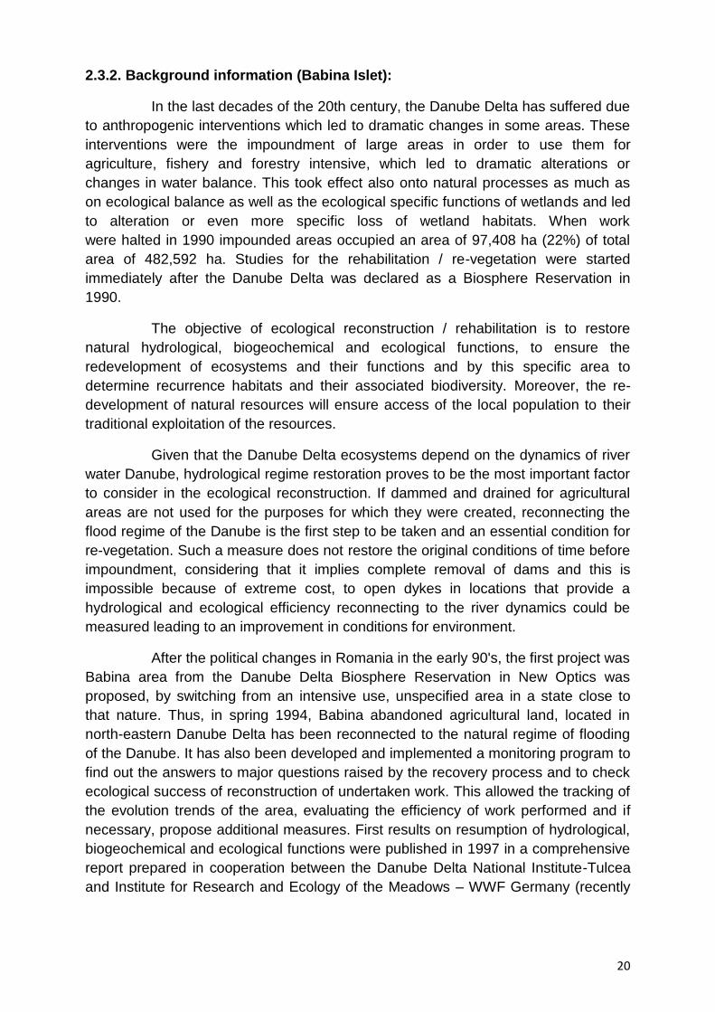
20
2.3.2. Background information (Babina Islet):
In the last decades of the 20th century, the Danube Delta has suffered dueto anthropogenic interventions which led to dramatic changes in some areas. Theseinterventions were the impoundment of large areas in order to use them foragriculture, fishery and forestry intensive, which led to dramatic alterations orchanges in water balance. This took effect also onto natural processes as much ason ecological balance as well as the ecological specific functions of wetlands and ledto alteration or even more specific loss of wetland habitats. When workwere halted in 1990 impounded areas occupied an area of 97,408 ha (22%) of totalarea of 482,592 ha. Studies for the rehabilitation / re-vegetation were startedimmediately after the Danube Delta was declared as a Biosphere Reservation in1990.
The objective of ecological reconstruction / rehabilitation is to restorenatural hydrological, biogeochemical and ecological functions, to ensure theredevelopment of ecosystems and their functions and by this specific area todetermine recurrence habitats and their associated biodiversity. Moreover, the re-development of natural resources will ensure access of the local population to theirtraditional exploitation of the resources.
Given that the Danube Delta ecosystems depend on the dynamics of riverwater Danube, hydrological regime restoration proves to be the most important factorto consider in the ecological reconstruction. If dammed and drained for agriculturalareas are not used for the purposes for which they were created, reconnecting theflood regime of the Danube is the first step to be taken and an essential condition forre-vegetation. Such a measure does not restore the original conditions of time beforeimpoundment, considering that it implies complete removal of dams and this isimpossible because of extreme cost, to open dykes in locations that provide ahydrological and ecological efficiency reconnecting to the river dynamics could bemeasured leading to an improvement in conditions for environment.
After the political changes in Romania in the early 90's, the first project wasBabina area from the Danube Delta Biosphere Reservation in New Optics wasproposed, by switching from an intensive use, unspecified area in a state close tothat nature. Thus, in spring 1994, Babina abandoned agricultural land, located innorth-eastern Danube Delta has been reconnected to the natural regime of floodingof the Danube. It has also been developed and implemented a monitoring program tofind out the answers to major questions raised by the recovery process and to checkecological success of reconstruction of undertaken work. This allowed the tracking ofthe evolution trends of the area, evaluating the efficiency of work performed and ifnecessary, propose additional measures. First results on resumption of hydrological,biogeochemical and ecological functions were published in 1997 in a comprehensivereport prepared in cooperation between the Danube Delta National Institute-Tulceaand Institute for Research and Ecology of the Meadows – WWF Germany (recently

21
integrated into the Institute for Water and river basin management in University ofKarlsruhe).
Monitoring activities carried out on more than 10 years have shown a fastdevelopment of the area, the hydrological regime with alternation with long periods ofhigh and low water levels, proved to be a key factor for re-vegetation. The conditionsdiffer from natural flooding. Before embankment, in their natural state flooding was ata large scale over the levees to shore island. In the current situation flooding thatoccurs mostly in the dyke breaches made in border dykes. With all these constraintsecosystem efficiency was restored by opening the dykes, bringing dynamics of theriver and reconnection. These works have provided a redevelopment of a specificbiodiversity resources and the Danube Delta biodiversity. The project implementationleaded in a change of mentality regarding the wetlands management, allowingrestoration of degraded areas and other man-made areas, both in the Danube Delta,as well as in its floodplain.
2.3.3. Extra information (Babina Islet):
Links to other sources of information online, and/or extra files (pdf, jpeg,etc) containing more detailed information about the project.
file name or link Description
Babina_Report.pdf Evolution of Babina polder after restoration works
http://www.indd.tim.ro/ Link with DDNI web site
Table 3: River typology, System A WFD (2000)
Indicator Classes
1 Ecoregion
1 Based on latitude and longitude and
(according to classification in Map A, WFD ,Annex XI)
2 Altitude
1 high: > 800 m
2 mid-altitude: 200 - 800 m
3 lowland: < 200 m
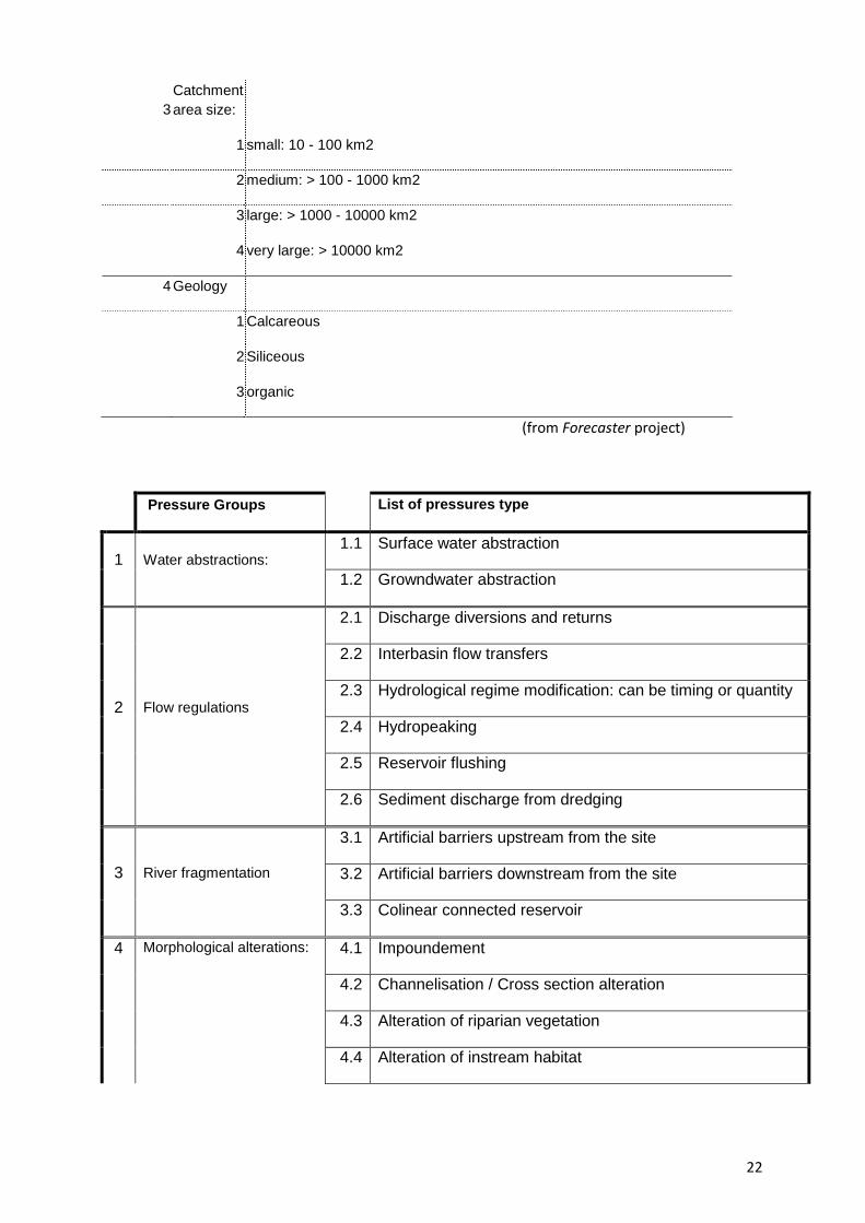
22
3Catchmentarea size:
1 small: 10 - 100 km2
2 medium: > 100 - 1000 km2
3 large: > 1000 - 10000 km2
4 very large: > 10000 km2
4 Geology
1 Calcareous
2 Siliceous
3 organic
(from Forecaster project)
Pressure Groups List of pressures type
1.1 Surface water abstraction1 Water abstractions:
1.2 Growndwater abstraction
2.1 Discharge diversions and returns
2.2 Interbasin flow transfers
2.3 Hydrological regime modification: can be timing or quantity
2.4 Hydropeaking
2.5 Reservoir flushing
2 Flow regulations
2.6 Sediment discharge from dredging
3.1 Artificial barriers upstream from the site
3.2 Artificial barriers downstream from the site3 River fragmentation
3.3 Colinear connected reservoir
4.1 Impoundement
4.2 Channelisation / Cross section alteration
4.3 Alteration of riparian vegetation
4 Morphological alterations:
4.4 Alteration of instream habitat
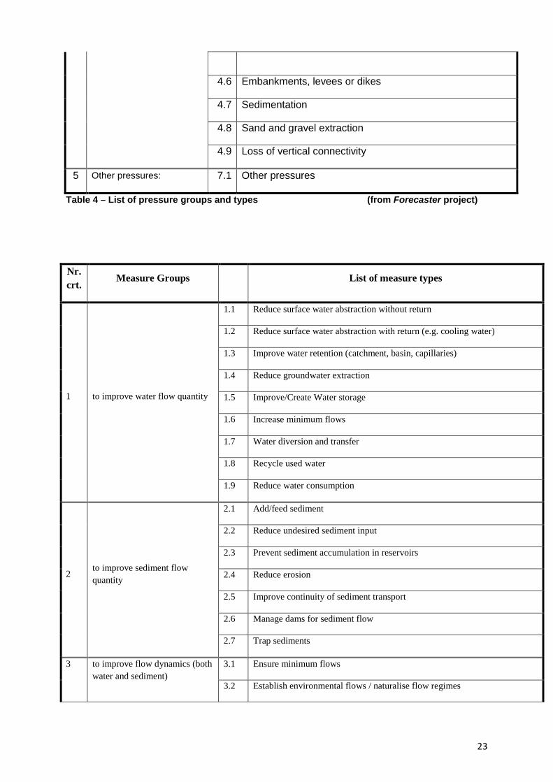
23
4.6 Embankments, levees or dikes
4.7 Sedimentation
4.8 Sand and gravel extraction
4.9 Loss of vertical connectivity
5 Other pressures: 7.1 Other pressures
Table 4 – List of pressure groups and types (from Forecaster project)
Nr.crt.
Measure Groups List of measure types
1.1 Reduce surface water abstraction without return
1.2 Reduce surface water abstraction with return (e.g. cooling water)
1.3 Improve water retention (catchment, basin, capillaries)
1.4 Reduce groundwater extraction
1.5 Improve/Create Water storage
1.6 Increase minimum flows
1.7 Water diversion and transfer
1.8 Recycle used water
1 to improve water flow quantity
1.9 Reduce water consumption
2.1 Add/feed sediment
2.2 Reduce undesired sediment input
2.3 Prevent sediment accumulation in reservoirs
2.4 Reduce erosion
2.5 Improve continuity of sediment transport
2.6 Manage dams for sediment flow
2to improve sediment flowquantity
2.7 Trap sediments
3.1 Ensure minimum flows3 to improve flow dynamics (bothwater and sediment)
3.2 Establish environmental flows / naturalise flow regimes

24
3.3 Modify hydropeaking
3.4 Increase flood frequency and duration in riparian zones or floodplains
3.5 Reduce anthropogenic flow peaks (e.g drainage, urban run-off)
3.6 Favour morphogenic flows
3.7 Shorten the length of impounded reaches
3.8 to link flood reduction with ecological restoration ('ecoflood')
3.9 to manage aquatic vegetation
4.1 Remove barrier (e.g weir, dam)
4.2 Install fish pass/bypass/side channel for upstream migration
4.3 Facilitate downstream migration
4.4 Modify culverts, syphons, piped streams (e.g. daylighting)
4.5 Manage sluice and weir operation for fish migration
4to improve longitudinalconnectivity/continuity
4.6 Fish-friendly turbines and pumping stations
5.1 Remeander water courses
5.2 Widen water courses
5.3 Shallow (i.e. opposite to deepen) water courses
5.4 Allow/increase lateral channel migration or river mobility
5.5 Narrow water courses
5to improve river bed depth andwidth variation
5.6 Create low flow channels in over-sized channels
6.1 Initiate natural channel dynamics to promote natural regeneration
6.2 Remove sediments (e.g. eutrophic, polluted, fine)
6.3 Modify aquatic vegetation ('weed') maintenance
6.4 Introduce large wood
6.5 Add sediments (gravel, sand)
6.6 Remove bank fixation
6.7 Recreate gravel bar and riffles
6.8 Remove or modify in-channel hydraulic structures (e.g. groynes, deflectors)
6to improve in-channel structureand substrate
6.9 Reduce impact of dredging
7 to improve lateral connectivity 7.1 Lower river banks or floodplains to enlarge inundation and flooding

25
7.2 Set back embankments, levees or dykes
7.3 Reconnect backwaters (oxbows, side channels) and wetlands
7.4 Remove hard engineering structures that impede laterel connectivity
8.1 Adjust land use (e.g. buffer strips) to develop riparian vegetation
8.2 Revegetate riparian zones
8.3 Remove bank fixation
8.4 Remove non-native substratum
8.5Adjust land use (e.g. buffer strips) to reduce nutrient, sediment input orshore erosion
8 to improve riparian zones
8.6 Develop riparian forest
9.1 Reconnect backwaters (oxbows, side channels) and wetlands
9.2 Restore wetlands
9.3 Retain floodwater (e.g. through local sluice management)
9.4 Improve backwaters (e.g. morphology, vegetation)
9.5 Set back embankments, levees or dykes
9.6 Lower river banks or floodplains to enlarge inundation and flooding
9to improve floodplains/off-channel habitats
9.7 Construct semi-natural/articificial wetlands or aquatic habitats
10Other aims to improvehydrological or morphologicalconditions
10 Reduce surface water abstraction without return
Table5 – List of measures groups and types (from Forecaster project)
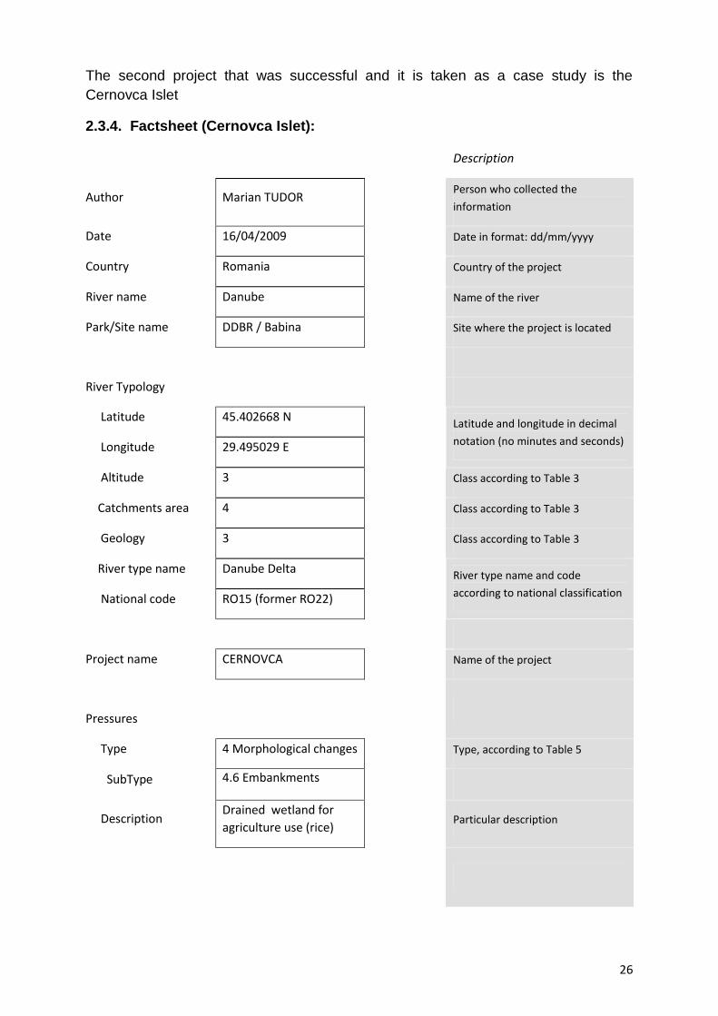
26
The second project that was successful and it is taken as a case study is theCernovca Islet
2.3.4. Factsheet (Cernovca Islet):
Description
Author Marian TUDORPerson who collected the
information
Date 16/04/2009 Date in format: dd/mm/yyyy
Country Romania Country of the project
River name Danube Name of the river
Park/Site name DDBR / Babina Site where the project is located
River Typology
Latitude 45.402668 N
Longitude 29.495029 E
Latitude and longitude in decimal
notation (no minutes and seconds)
Altitude 3 Class according to Table 3
Catchments area 4 Class according to Table 3
Geology 3 Class according to Table 3
River type name Danube Delta
National code RO15 (former RO22)
River type name and code
according to national classification
Project name CERNOVCA Name of the project
Pressures
Type 4 Morphological changes Type, according to Table 5
SubType 4.6 Embankments
DescriptionDrained wetland foragriculture use (rice)
Particular description

27
Measures
Group7 Improve the lateralconnectivity
Group according to Tabel 5
Measure7.2 Set backembankments, levees ordykes
According to Tabel 5
Description Dyke breaches Particular description
Project size 1580 Units Ha Area covered by the project
Approximate cost 10000 – 100000 Units Euro Approximate cost of the project
SynergyNutrients retention, wildlife habitat Combination of the project with
other functions (e.g. flood
protection, navigation)
Status Finalized Planned, in progress or finished
Period of realization 1996 Approximate dates
Evaluation YES Yes or No
Implemented by
Danube Delta NationalInstitute for Researchand Development(DDNI)
Name of organization who
implemented the works
(from Forecaster project)
28
2.3.5. Cernovca background Information:
The first attempt of large-scale farming in the Delta dates back about 100years (1895) and concerns an area situated between km 82 and 88 on the St.Georghe branch, the so-called 'Garden of the Dutch'. ANTIPA (1907, 1911) considersthe more holistic problems of agricultural use in the inundation area on the lowerDanube and the Delta (see also BOTNARIUC 1960). He points out that farming inthe Delta "has on the one hand to be founded on a most precise knowledge of thephysical and biologic conditions of these areas, i.e. the climate, the soil nature,hydrographical conditions, fauna and flora and that on the other hand any generaland specific economical conditions have to be considered” (ANTIPA, 1911, p. 387).An analysis of the Danube Delta's ecological conditions leads to the conclusion, thatfarming is only possible on the embankments (grinduri) and the higher situated floodchannels. (***, 1997)
The first embankment of a 3400 ha area was carried out from 1938-1940on Tataru island situated upstream of Babina and Cernovca in the Chilia-branch
(RuDESCU et al. 1965). In 1983, the Programme for the remodeling andintegral use of the natural resources in the Danube Delta' (decree Nr. 92/1983)planned the embankment of Babina, Cernovca and other areas for agricultural use.(***, 1997)
Cernovca had been reserved for rice-growing although the soil analysisshowed that the island consisted mainly of agriculturally unusable marshland.Moreover, the soil salinization in the western part of the islet, caused by a highevaporation rate, had not been taken into account (see also ANTIPA 1 91 1) Thiswas likely because under natural conditions, and thanks to periodical inundations,there seemed to be a balance that prevented salinization. Other information pointingout the high soil salinization and the formation of solonchak-soils as a consequenceof four decades of embankment and drainages in Ukraine, on the left Chilia - branchbank, had as well been ignored. (***, 1997)
The dykes for Babina were initiated in 1985 and in 1987 for Cernovca.As a consequence of these measures the islands were cut off from theinundation regime of the Danube. The dams surrounding the islands are situatedat a distance of about 75 -1 00 m from their bank and are about 2.05-3.79 mover Black Sea level (this included freeboard to prevent inundation). Thematerial needed for the construction of the dams was excavated along the dam,so that outside the dam a circular channel was formed. For Cernovca, this damis partly situated inside (***, 1997)
In order to lower the groundwater level, a network of main andsecondary channels as well as pumping stations was constructed. In Babinapolder, leveling works were realized and the reed rhizomes were removed bymeans of mechanical measures. Therefore, the ground was ploughed 28-30 cmdeep. (***, 1997).

29
These measures radically altered the relief of the islets which hadformerly been shaped by the Danube. Although on Babina the changes werecompleted. On Cernovca the measures were not brought to an end. OnCernovca only the western part was ploughed which is evident in the vegetationdistribution in the furrows with small elevation differences. (***, 1997)
From an ecological point of view, cutting off the islands from theDanube flood regime meant elimination of a major factor and caused dramaticalterations as regards the water balance. Leveling and canalization destroyedmajor parts of the islands characteristic water network of small watercoursesand flood channels. Air photographies show that it is true for almost all CernovcaIslet; the former streams have been preserved. On Cernovca, however, thestructures of the former flood channels and smaller watercourses are moredistinctly visible. Only groundwater fluctuations of -0.80 to 1.7 3 m below BlackSea level in Cernovca polder implied a slight dynamics. Within the drainageditch and channel network of the polder, the water circulation was almost non-existent. (***, 1997)
2.3.6 Extra information ((Cernovca Islet):
Links to other sources of information online, and/or extra files (pdf, jpeg,etc) containing more detailed information about the project.
file name or link Description
Hard copy Ecological restoration in the Danube Delta BiosphereReserve / Romania
http://www.indd.tim.ro/ Link with DDNI web site
30
2.3.7. Ecological reconstruction implementation results (from the studycases)
2.3.7.1 For Babina Islet (***, 2008)
The restoration of Babina Island was a significant step forward towards asustainable development of this area. Both the redevelopment of the natural habitatsand its biodiversity and the use of resources that are bound to traditionalmanagement methods stayed abreast of changes. After the political reversal inRomania, Babina Islet was the first project in the Danube Delta where new pathswere stroke, away from an intensive, site-unspecific use back to near-naturalstructures, exemplar for nature r conservation with an for man. It caused a change ofmind and offered new incentives to restore further flood prone areas that had beenaltered by man, in the Danube Delta but also beyond.
The monitoring conducted over 10 years accounts for a relatively rapiddevelopment of the area, the hydrological regime with its fluctuating floods and dryperiods representing the key factor for restoration. Flood conditions do, however,differ from the natural flood situation. Before the construction of the dykes, i.e. undernatural conditions, it occurred with a large-scale over-flooding of the islet. In the caseof the dyked Babina Islet it merely occurs in the area of the dam openings (STARAS2001).
Despite of these constraints the efficiency of the ecosystem has beenreestablished by an opening of the dyke in specific hydraulically and ecologicallyeffective spots and the reconnection to the river dynamics. This ensured aredevelopment of the site-specific biodiversity and the resources.
The monitoring of the hydrological regime in close relation with morpho-hydrological changes revealed the alterations in the artificial canals.
The reestablishment of the flood regime induced a process of rehabilitationof the plankton fauna comparable to permanent eutrophic waters with a significantincrease in the species number. This proves that the water quality has graduallychanged in towards the positive approaching natural conditions that are specific ofclear water habitats where R, the development of aquatic vegetation sustains a richand abundant zooplankton community i.e. an excellent food source for fish.
A specimen and species-abundant fauna of macro-zoo-benthos populatestagnating waters, permanent and macrophyte-rich. The composition according tonutrition types confirms a well-operating interplay between macrophytes, macro-zoo-benthos and fish. If the present hydrological conditions are maintained, there will beno significant changes or infringements of the zoo-benthos fauna in the short ormedium term. In the long run, however, the insufficient water exchange in the watersystem of Babina will have indirect, negative effects on the macro-zoo-benthos.
The reconnection to the Danube River and the sc linking up to theneighboring ecosystems allowed the islet to take up again its function as habitat andspawning ground for fish. The studies conducted, prove that the redeveloped aquatichabitats play an important ecological role for reproduction and nutrition of fish.
31
Especially phytophilous species and species spawning on mollusks havebeen reestablished on Babina after the islet's reconnection to the flood regime of theDanube River.
The species occurring in the Babina area are characteristic eutrophicspecies of the Danube catchments area that occur both in running and in stagnatingwaters. Other limnophilous species, characteristic of stagnating waters do occur aswell, the latter being predominant in the Babina Islet area.
The studies on diversity and structure of the fish populations show acharacteristic ichthyofauna of eutrophic waters. This is because the area offers therespective habitats for their natural reproduction, adequate feeding and raisinggrounds for juvenile and adult fish. Diversity and structure of the fish communitiesvary from one habitat to another with the result that they may be considered asindicators for the ecological condition of the respective areas.
The development and stabilization of the fish populations involve the useoffish resources and their socio-economic significance for the local populations.Ecological restoration can be considered as an economic alternative for themanagement of embanked and unprofitable or abandoned polders.
The reconnection to the dynamics of the Danube River and theredevelopment of a mosaic. of stagnant and running waters within the island led intheir turn to a rapid redevelopment of the aquatic vegetation and its communities.This is why already during the second year after the flooding a major part of theaquatic vegetation occurred in the area of the island. From 1998 their standsincreased so that the plant communities became relatively stable. With a fewfluctuation caused by the hydrological regime of the Danube the communitiesbecame distinctly apparent and comparable to natural areas in the Delta.
2.3.7.2. For Cernovca Islet (***, 1997)
A monitoring programme was established to document thedevelopments that occurred after the reconnection of the islets to the Danube'sflood regime and to verify the success of the rehabilitation measures. A studycomparing the data obtained before and after the dyke constructions should pro-vide the opportunity to show developments and evaluate the measures. Themonitoring programme comprises studies focused on both terrestrial and aquaticinvestigation spots.
The monitoring considers soils, vegetation and fauna with regard toarea-specific biodiversity arising from changed ecological conditions impliedby the reconnection to the flood regime of the Danube. After the dyke openings,the areas were analyzed with regard to the reestablishment of the ecologicalfunctions of these floodplains influenced by the river dynamics. Theredevelopment of natural, area specific resources has been considered as well.

32
For the areas, the reestablishment of the hydrological regime and ofthe hydrological functions also meant a restoration of the following ecologicalfunctions:
• habitat for plants and animals, in particular,
• habitat and reproduction area for fish,
• habitat for water and wading birds,
• biodiversity reservoir providing,
• the guarantee of genetic resources
- biocorridor / genetic exchange,- bioproduction,
• nutrient accumulation and turnover/nutrient cycling:
- sediment and pollutant retention,- filter for the Black Sea.
The reestablishment of the ecological functions also implies theredevelopment of area-specific resources and the local population's traditionaleconomical occupations: fishing, hunting, reed harvesting, pasturing, recreationetc.
The significant floodplain specific diversity maintained in the distincthabitats of the islands also represents a considerable genetic potential thatwould have been lost in the long run if the areas remained embanked. After theflooding, the biogeochemical processes, completed by the soils in the polder'secosystem, changed. Vegetation, particularly the broad leaf, rapidlyregenerating reed, show a high bio-production and play an essential role fornutriment accumulation, sediment and pollutant retention and as a filter for theBlack Sea.
The rehabilitation of Cernovca was initiated with two openings inthe surrounding dyke (April 1996). Its hydrological function as a water reservoiris reflected by a water retention volume of 28 million m3 water. On Cernovca,the reconnection to the water fluctuations of the Danube was the initiatingelement of the rehabilitation process. Immediately after the opening, the islandtook up again its ecological function as a reproduction ground for fish and as ahabitat for water and wading birds. The limnological investigations prove theexistence and development of zoo-benthos as nutrition for fish, although nodistinct development tendencies could be observed up to now.
The waters of Cernovca indicate a considerably higher electricalconductivity than those of Babina, which is an indirect salt indicator.

33
After a mostly near-natural reestablishment of the hydrological regime,all other ecological factors were reestablished and the natural floodplainresources could again redevelop. The analysis of both the hydraulicallyecological measures and the monitoring activities carried out up to now will beused to show whether additional measures (further dyke openings) arenecessary.
The traditional use of the natural, regenerating resources may occuras a function of the rehabilitation of water levels. After a stabilization of theconditions, economical use of the fishing grounds, the pastures in the westernparts of both islands and an ecologically sound reed use can occur. Thedevelopment of the game stands still requires further investigation.
CONCLUSIONS AND RECOMMENDATIONS
From the information mentioned above, the following conclusions could be
highlighted:
I. Healthy, self-sustaining river systems provide important ecological andsocial goods and services upon which human life depends (Postel & Richter 2003cited by Palmer, 2005). Concern over sustaining these services has stimulated majorrestoration efforts. Indeed, river and stream restoration has become a world-widephenomenon as well as a booming enterprise (NRC 1996; Holmes 1998; Henry,Amoros & Roset 2002; Ormerod 2003 cited by Palmer, 2005). Billions of dollars arebeing spent on stream and river restoration in the USA alone (Palmer et al. 2003;Malakoff 2004 cited by Palmer, 2005).
Although there is growing consensus about the importance of riverrestoration, agreement on what constitutes a successful restoration project continuesto be lacking.
Given the rapid rate of global degradation of freshwaters (Gleick 2003cited by Palmer, 2005), it is time to agree on what constitutes successful river andstream restoration.
There are five criteria for measuring success, hereafter referred to as thestandards for ecologically successful river restoration. We chose a forum to proposethese in order to elicit broad input from the community, including critiques andsuggestions for expanding or revising what we propose.
a) The design of an ecological river restoration project should bebased on a specified guiding image of a more dynamic, healthy river thatcould exist at the site.
b) The river’s ecological condition must be measurably improved.c) The river system must be more self-sustaining and resilient to
external perturbations so that only minimal follow-up maintenance is needed.d) During the construction phase, no lasting harm should be
inflicted on the ecosystem.e) Both pre- and post-assessment must be completed and data
made publicly available.
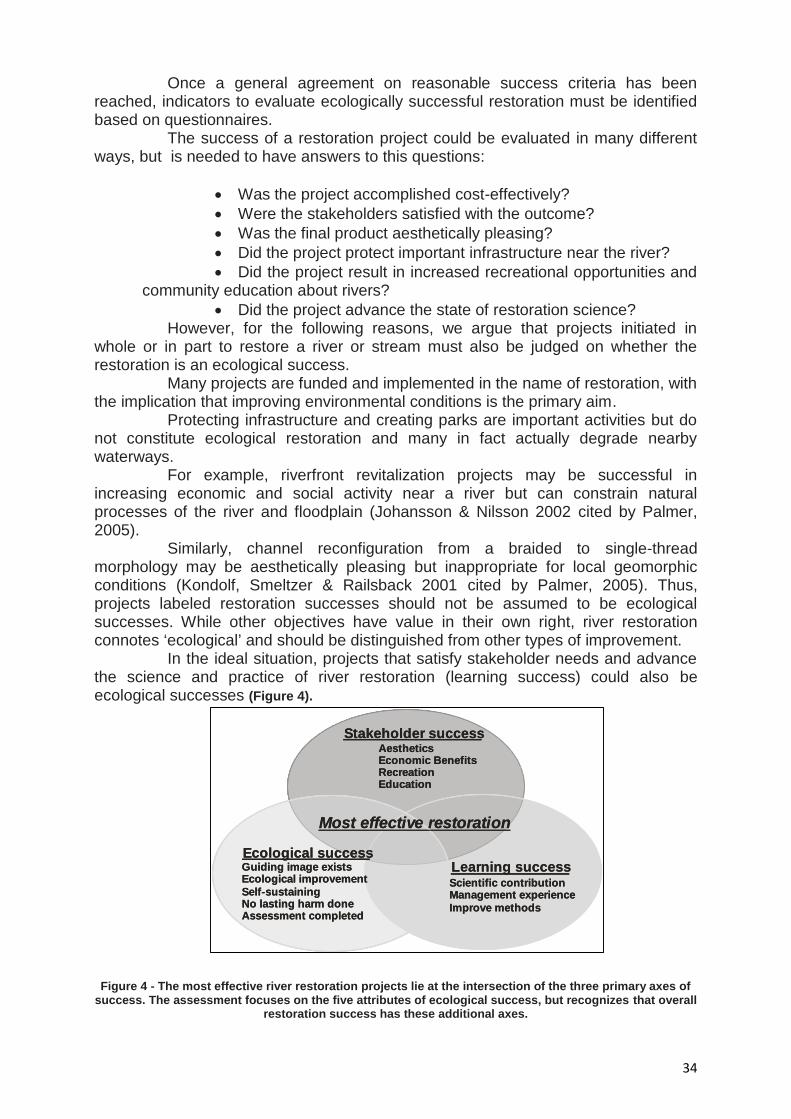
34
Stakeholder successAestheticsEconomic BenefitsRecreationEducation
Most effective restoration
Ecological successLearning successGuiding image exists
Ecological improvementSelf-sustainingNo lasting harm doneAssessment completed
Scientific contributionManagement experienceImprove methods
Stakeholder successAestheticsEconomic BenefitsRecreationEducation
Most effective restoration
Ecological successLearning successGuiding image exists
Ecological improvementSelf-sustainingNo lasting harm doneAssessment completed
Scientific contributionManagement experienceImprove methods
Stakeholder successAestheticsEconomic BenefitsRecreationEducation
Most effective restoration
Ecological successLearning successGuiding image exists
Ecological improvementSelf-sustainingNo lasting harm doneAssessment completed
Scientific contributionManagement experienceImprove methods
Stakeholder successAestheticsEconomic BenefitsRecreationEducation
Most effective restoration
Ecological successLearning successGuiding image exists
Ecological improvementSelf-sustainingNo lasting harm doneAssessment completed
Scientific contributionManagement experienceImprove methods
Stakeholder successAestheticsEconomic BenefitsRecreationEducation
Most effective restoration
Ecological successLearning successGuiding image exists
Ecological improvementSelf-sustainingNo lasting harm doneAssessment completed
Scientific contributionManagement experienceImprove methods
Stakeholder successAestheticsEconomic BenefitsRecreationEducation
Most effective restoration
Ecological successLearning successGuiding image exists
Ecological improvementSelf-sustainingNo lasting harm doneAssessment completed
Scientific contributionManagement experienceImprove methods
Stakeholder successAestheticsEconomic BenefitsRecreationEducation
Most effective restoration
Ecological successLearning successGuiding image exists
Ecological improvementSelf-sustainingNo lasting harm doneAssessment completed
Scientific contributionManagement experienceImprove methods
Stakeholder successAestheticsEconomic BenefitsRecreationEducation
Most effective restoration
Ecological successLearning successGuiding image exists
Ecological improvementSelf-sustainingNo lasting harm doneAssessment completed
Scientific contributionManagement experienceImprove methods
Once a general agreement on reasonable success criteria has beenreached, indicators to evaluate ecologically successful restoration must be identifiedbased on questionnaires.
The success of a restoration project could be evaluated in many differentways, but is needed to have answers to this questions:
Was the project accomplished cost-effectively? Were the stakeholders satisfied with the outcome? Was the final product aesthetically pleasing? Did the project protect important infrastructure near the river? Did the project result in increased recreational opportunities and
community education about rivers? Did the project advance the state of restoration science?
However, for the following reasons, we argue that projects initiated inwhole or in part to restore a river or stream must also be judged on whether therestoration is an ecological success.
Many projects are funded and implemented in the name of restoration, withthe implication that improving environmental conditions is the primary aim.
Protecting infrastructure and creating parks are important activities but donot constitute ecological restoration and many in fact actually degrade nearbywaterways.
For example, riverfront revitalization projects may be successful inincreasing economic and social activity near a river but can constrain naturalprocesses of the river and floodplain (Johansson & Nilsson 2002 cited by Palmer,2005).
Similarly, channel reconfiguration from a braided to single-threadmorphology may be aesthetically pleasing but inappropriate for local geomorphicconditions (Kondolf, Smeltzer & Railsback 2001 cited by Palmer, 2005). Thus,projects labeled restoration successes should not be assumed to be ecologicalsuccesses. While other objectives have value in their own right, river restorationconnotes ‘ecological’ and should be distinguished from other types of improvement.
In the ideal situation, projects that satisfy stakeholder needs and advancethe science and practice of river restoration (learning success) could also beecological successes (Figure 4).
Figure 4 - The most effective river restoration projects lie at the intersection of the three primary axes ofsuccess. The assessment focuses on the five attributes of ecological success, but recognizes that overall
restoration success has these additional axes.
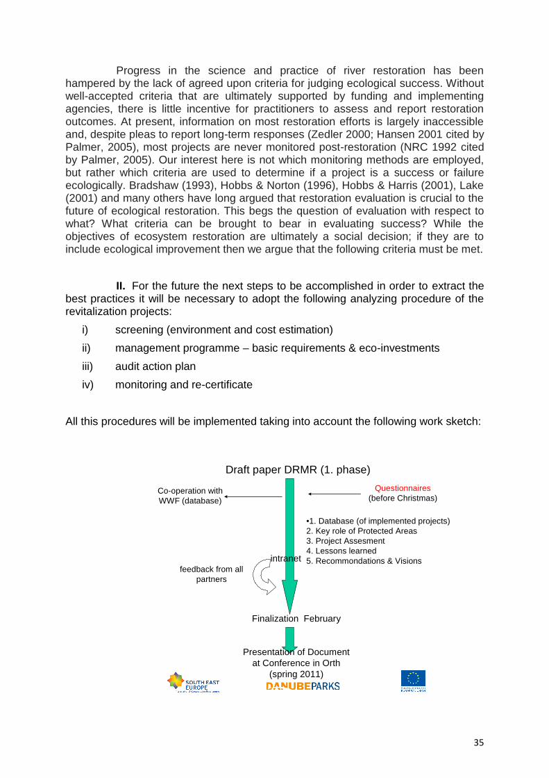
35
Progress in the science and practice of river restoration has beenhampered by the lack of agreed upon criteria for judging ecological success. Withoutwell-accepted criteria that are ultimately supported by funding and implementingagencies, there is little incentive for practitioners to assess and report restorationoutcomes. At present, information on most restoration efforts is largely inaccessibleand, despite pleas to report long-term responses (Zedler 2000; Hansen 2001 cited byPalmer, 2005), most projects are never monitored post-restoration (NRC 1992 citedby Palmer, 2005). Our interest here is not which monitoring methods are employed,but rather which criteria are used to determine if a project is a success or failureecologically. Bradshaw (1993), Hobbs & Norton (1996), Hobbs & Harris (2001), Lake(2001) and many others have long argued that restoration evaluation is crucial to thefuture of ecological restoration. This begs the question of evaluation with respect towhat? What criteria can be brought to bear in evaluating success? While theobjectives of ecosystem restoration are ultimately a social decision; if they are toinclude ecological improvement then we argue that the following criteria must be met.
II. For the future the next steps to be accomplished in order to extract thebest practices it will be necessary to adopt the following analyzing procedure of therevitalization projects:
i) screening (environment and cost estimation)ii) management programme – basic requirements & eco-investmentsiii) audit action planiv) monitoring and re-certificate
All this procedures will be implemented taking into account the following work sketch:
Draft paper DRMR (1. phase)
Finalization February
Co-operation withWWF (database)
Questionnaires(before Christmas)
Presentation of Documentat Conference in Orth
(spring 2011)
•1. Database (of implemented projects)2. Key role of Protected Areas3. Project Assesment4. Lessons learned5. Recommondations & Visionsintranet
feedback from allpartners
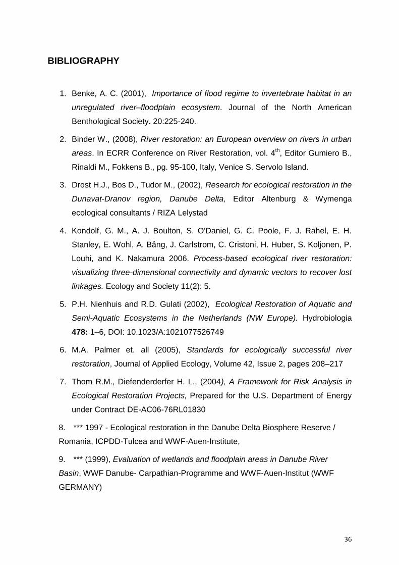
36
BIBLIOGRAPHY
1. Benke, A. C. (2001), Importance of flood regime to invertebrate habitat in an
unregulated river–floodplain ecosystem. Journal of the North American
Benthological Society. 20:225-240.
2. Binder W., (2008), River restoration: an European overview on rivers in urban
areas. In ECRR Conference on River Restoration, vol. 4th, Editor Gumiero B.,
Rinaldi M., Fokkens B., pg. 95-100, Italy, Venice S. Servolo Island.
3. Drost H.J., Bos D., Tudor M., (2002), Research for ecological restoration in the
Dunavat-Dranov region, Danube Delta, Editor Altenburg & Wymenga
ecological consultants / RIZA Lelystad
4. Kondolf, G. M., A. J. Boulton, S. O'Daniel, G. C. Poole, F. J. Rahel, E. H.
Stanley, E. Wohl, A. Bång, J. Carlstrom, C. Cristoni, H. Huber, S. Koljonen, P.
Louhi, and K. Nakamura 2006. Process-based ecological river restoration:
visualizing three-dimensional connectivity and dynamic vectors to recover lost
linkages. Ecology and Society 11(2): 5.
5. P.H. Nienhuis and R.D. Gulati (2002), Ecological Restoration of Aquatic and
Semi-Aquatic Ecosystems in the Netherlands (NW Europe). Hydrobiologia
478: 1–6, DOI: 10.1023/A:1021077526749
6. M.A. Palmer et. all (2005), Standards for ecologically successful river
restoration, Journal of Applied Ecology, Volume 42, Issue 2, pages 208–217
7. Thom R.M., Diefenderderfer H. L., (2004), A Framework for Risk Analysis in
Ecological Restoration Projects, Prepared for the U.S. Department of Energy
under Contract DE-AC06-76RL01830
8. *** 1997 - Ecological restoration in the Danube Delta Biosphere Reserve /
Romania, ICPDD-Tulcea and WWF-Auen-Institute,
9. *** (1999), Evaluation of wetlands and floodplain areas in Danube River
Basin, WWF Danube- Carpathian-Programme and WWF-Auen-Institut (WWF
GERMANY)
37
10. *** 2008 - Evolution of Babina polder after restoration works, WWF-Germany
and DDNI-Tulcea, Kraft-Druck Ettlingen,
Internet sources:
www.broz.sk
www.biomura.si
http://bulgarsko.eu/ovm.php?l=en&pageNum_Ovm_All=0&totalRows_Ovm_All=113&id=17
http://siteresources.worldbank.org/BULGARIAEXTN/Resources/WetlandsBroshure6.pdf
http://www.icpdr.org/icpdr-pages/dw0803_p_06.htm
http://forecaster.ontwikkel.gisinternet.nl/index.php?title=Description
www.life-wachau.at
www.lariverrmp.org
http://forecaster.deltares.nl/index.php?title=Babina
http://forecaster.deltares.nl/index.php?title=Cernovca

MINISTERUL MEDIULUI SI PADURILOR INSTITUTUL NATIONAL DE CERCETARE-DEZVOLTARE PENTRU PROTECTIA MEDIULUI
INSTITUTUL NATIONAL DE CERCETARE-DEZVOLTARE
DELTA DUNARII
TULCEA - Str. Babadag nr.165, cod 820112, Tel.0240-53 15 20, Fax 0240-53 35 47
E-mail:[email protected] Internet : www.indd.tim.ro
DANUBE RIVER’S MORPHOLOGY AND REVITALIZATION TO THE SERVICE CONTRACT - STUDIES DEVELOPMENT NNNOOO... 444111444 /// 222000111000
- REPORT - Phase 3 – Preparing the guide for the Danube area
BENEFICIARY:
DANUBE DELTA BIOSPHERE RESERVE AUTHORITY TULCEA
- FEBRUARY 2011 -

2
MINISTERUL MEDIULUI SI PADURILOR INSTITUTUL NATIONAL DE CERCETARE-DEZVOLTARE PENTRU PROTECTIA MEDIULUI
INSTITUTUL NATIONAL DE CERCETARE-DEZVOLTARE
DELTA DUNARII
TULCEA - Str. Babadag nr.165, cod 820112, Tel.0240-53 15 20, Fax 0240-53 35 47
E-mail:[email protected] Internet : www.indd.tim.ro
THE SERVICE CONTRACT - STUDIES DEVELOPMENT NNNOOO... 444111444 /// 222000111000
STUDY NAME: DANUBE RIVER’S MORPHOLOGY AND REVITALIZATION
PROGRAMME NAME:
TRANSNATIONAL COOPERATION PROGRAMME FOR SOUTH-EAST EUROPE 2007-2013 PROJECT NAME:
DANUBEPARKS - DANUBEPARKS - DANUBE RIVER NETWORK OF PROTECTED AREAS - DEVELOPMENT AND IMPLEMENT THE TRANSNATIONAL STRATEGIES FOR CONSERVATION OF DANUBE NATURAL HERITAGE
- REPORT - Phase 3 – Preparing the guide for the Danube area BENEFICIARY :
DANUBE DELTA BIOSPHERE RESERVE AUTHORITY TULCEA EXECUTANT :
DANUBE DELTA NATIONAL INSTITUTE FOR RESEARCH AND DEVELOPMENT
General Director DDNI Tulcea Eng. Romulus ŞTIUCĂ
Scientific Director DDNI Tulcea Dr. Eng. Mircea STARAŞ
Project Coordinator DDNI Tulcea Dr. Eng. Iulian NICHERSU
- FEBRUARY 2011 -

3
WORK TEAM
DANUBE DELTA NATIONAL INSTITUTE FOR RESEARCH AND DEVELOPMENT :
4
T A B L E O F C O N T E N T S:
Pg. I. INTRODUCTION.......................................................................................................6
I. Synergies between revitalization and ecological restoration.....................................................8
I.2 The approach framework of the Danube in the European context - the Danube Strategy & ESPON
Programme 2013......................................................................................................................................10
I.3 Characterization of Danube River Basin (DRB) in terms of morphology and
revitalization..............................................................................................................................................21
I.4 Conceptual Framework and its relevance within Danube River’s Revitalisayion..................23
II. DIAGNOSIS...........................................................................................................34
II.1 Methods used in diagnosis...............................................................................................34
II.1.1 Analyse through Land and Ecosistem Accounting
(LEAC)........................................................................................................................................34
II.1.2 Analyse based on DPSIR indicators (Driving Force, Presure, State, Impact and
Response)......................................................................................................................38
II.1.3. Multicriteria analysis.............................................................................................46
II. 1. 4 Risk analysis........................................................................................................50
II.1.5 Stakeholder analysis....... .....................................................................................52
III. DIMENSIONS OF DOCUMENTATIONS AND ANALYSIS.............................................55
III. 1 Spatial dimension.....................................................................................................55
III.1.1 River Basin Level...... ...........................................................................................55
III.1.2 Regional level......... .............................................................................................57
III.1.3 Local level......... ..................................................................................................63
III.2 Typological dimension.................. ............................................................................68
III.2.1 Surface water. Characterisation of surface water body types.............................68
5
III.2.2. Ecoregions and surface water body types...........................................................70
III.2.3 Establishment of type-specific reference conditions for surface water body
types............. .............................................................................................................................73
III.2.4 Identification of Pressures....... .............................................................................75
III.2.5 Assessment of Impact................. .........................................................................76
III. 3 Thematic dimension........ ...........................................................................................76
III. 4. Progressive development of tree problems (Logical Framework Analyse) and the
SketchMatch method for scanrios and possible renaturation measures....................................78
III.4.1 Progressive development of tree problems......... ...............................................79
III.4.2 Metoda SketchMatch (SM)...................................................................................79
IV. LESSONS FOR BEST PRACTICES ............................................................82
IV.1 Multicriterial analyse........................................................................................................84
V GUIDE OF MANAGEMENT MEASURES.............................................89
VI Relation between the Danube Parks network and revitalisation parks................................93
VI.1 Spatial planning approach in river basin............................................................................94
VI.2 The concept of Integrated Regional Ecological Network in the National Ecological Network
and European international initiatives........................................................................................95
VI.3 National and european ecological network.........................................................................98
REFERENCES………….….….……….....……………………………...............……………….104

6
Phase 3 – Preparing the guide for the Danube area
I. INTRODUCTION
Rivers have always been with huge interest for life’s existence and
development. The ecosystems created in the proximity of rivers are very complex
including a large number of species of plants and animals that are interact. All these
inter-relations are into a stable equilibrium. The intervention of human society on
rivers has determined the instability of this equilibrium shifting towards the extreme
limits. Rivers are an important component of the European landscape and of great
significance for biodiversity.
In this sense we can recall some of the “interventions” that has determined the
instability of the equilibrium: over-exploitation of the riparian resources (biotic and
abiotic), planning the river course (damaging them by embankment, course changing
etc.), establishment of the human settlements in lower floodplain.
The Danube River has suffered alteration processes of the ecological balance
in order to development of the human society. From the existing studies it comes to
the conclusion that in the alteration process of the Danube have been destroyed
dominating natural systems and have created industrial structures with economical
purpose (navigation, hydro-energy, agriculture, ports etc.) that is damaging the
Danube river, because of losing the floodplains and morphological structures.
Danube River regarded like an entire system raised the idea of making some
zones with potential for local revitalization with an entire system effect (Figure 1).
Transformations of these ecosystems in the floodplains into terrestrial
ecosystems have reduced their functions (ecological, economical, recreational,
esthetical and educational) to a single one – economical.
The river restoration projects preconditions are ecological functions. This
means that rivers are dynamic systems. They are formed by the natural
characteristics of the drainage basin like climate, geology, tectonic, vegetation and
land use. The discharge depending from precipitation is fluctuating. The power of
running water and the amount of transported solids influence the morphological
process and the geometry of the river channel. This includes bank erosion and
sedimentation, natural restoration of riffle and pool and migration of the riverbed
within the flood plain.

7
The geometric features of the river channel e.g. plant form, longitudinal and
cross sections as well the substrate in the river channel are depending from the
conditions in the watershed area. River and floodplain are an unit. (Binder, 2008)
The part presented above forms the abiotical part of a river system. The biotic
part molds the abiotic part. The vegetation along the river and in the flood plain is in
natural succession, its zonation spans from pioneer vegetation to alluvial woodland.
The morphological structure housing a mosaic of biotopes for animals and plants.
This explains why natural river systems offer such a wide range of habitats and why
they are today in most European countries protected by Natura2000. Their reference
status is equal to the high ecological status of the Water Frame Directive (WFD).
(Binder, 2008)
The management of international water resources and large transboundary
rivers is a challenging task because of the administrative and socio-cultural
differences within the catchments, the heterogeneity of the encompassing
landscapes, the multiple and often competing water uses, and, not least, the
difficulty of enforcing international laws at regional and local levels.
Moreover, managing landscapes as complex as large river-floodplain networks
requires a comprehensive understanding of the underlying ecological structure-
function relationships at various spatiotemporal scales. Hence, tailor-made water
management strategies need to be properly selected, designed, and implemented
based on sound ecological principles, the best available scientific knowledge, and
stakeholder participation (after Uitto and Duda, 2002; Dudgeon et al.,2006; Hein et
al., 2006; Quevauviller, 2010, quoted by Sommerwerk N. et al., 2010).
The Danube River Basin (DRB) is the most international river in the world,
characterized by exceptionally diverse ecological, historical, and socioeconomic
properties. Its unique biodiversity and high ecological potential make the DRB one of
the Earth’s 200 most valuable ecoregions (after Olson and Dinerstein, 1998, quoted
by Sommerwerk N. et al., 2010). At the same time, the DRB is listed among the
world’s top 10 rivers at risk (after Wong et al. 2007, quoted by Sommerwerk N. et al.,
2010).

8
I.1 Synergies between revitalization and ecological restoration to restore - tranzitive verb. (paintings, architectural monuments, etc.) A return to baseline, to put back into a former or original state [Sil. -Sit-u-] / <fr. restaurer, lat. restaurare to revitalize - transitive verb - to give new life or vigor to (< fr. revitaliser)
Anthropic degradation of aquatic ecosystems, whether we refer to rivers,
streams, lakes or coastal areas, deltas, is an omnipresent reality with major
implications for centuries, if we refer to the Danube basin. Ecosystems are affected
by morphological, chemical, hydrological or biological changes, all creating pressure
on the structure and functions of ecosystems. Human impact on ecosystems is the
main theme of numerous studies on the degree of anthropic degradation and many
monitoring and evaluation indicators have been developed, to diagnose the state of
ecosystems. In response to anthropic pressures that led to the degradation of
ecosystems, have been tried measures of reconstruction / rehabilitation or ecological
restoration. Most often, ecological restoration is described as successful when
communities began to recover, and the pressure was reduced or even eliminated.
However, the simple approach of removing the effects of environmental degradation
is not expected to be achieved and biotic components will continue to be in poor
condition. Measures to restore at small spatial scales - local, will not meet the
requirements for restoration of river basin with degraded ecosystems what is
essential to structuring of the restoration work at space level. Also, if monitoring
activities are carried out only in the short term, there will be insufficient to quantify on
long-term the environmental restoration requirements to functional and structural
level. Not the least, the knowledge about recovery potential of the basin is unknown.
Ecological restoration is a discipline that has developed over 20 years,
covering various topics with applications on habitat, species.
The necessity of enhanced measures for ecological restoration is an inevitable
consequence of ecosystem degradation at functional and structural level. Human
population growth, technological and cultural development, simultaneous with natural
resources absorbing, lead to increased degradation of ecosystems.

9
Revitalization as defined in Los Angeles River Master Plan is a concept that
accountre both measures of ecological restoration, rehabilitation and ecological
reconstruction and development opportunities for local communities in the context of
sustainability.
If rebuilding of longitudinal continuity, lateral connectivityand the temporal one
is subject to revitalization or ecological restoration (Figure 1), the development of of
local communities opportunities and cultural values will be treated by the concept of
amelioration/ improvement (english mitigation).
Figure 1 – Synergy Revitalization - Ecological Restoration Scheme (Perrow R.M, Davy
A.J., 2002)
Natural resources managers must ensure a balance between legal, social,
economic, biological problems, but also through adaptive management and spatial
planning and of socio-ecological complex, will create strategies to achieve
environmental objectives. Environmental objectives can vary from single species
protection and management to a complex management of communities and
ecosystems. Social objectives are intended to perpetuate or restore endangered
species or manage or expand commercial, sport, or use, directly or indirectly to meet
10
the needs of a changing society. The legal system requires quantitative and
qualitative assessment of these issues, based on:
Analytical models;
Analysis of species-habitat relationship.;
Population sustainability assessment and risk assessments.
Support the framework for decision-makers
Summary of available knowledge
Mega Database
Technical support for watershed planning and recovery of species
To facilitate scientific discussion and networking
Develop and implement tools to support planning
Technical Consultation on biological and ecological aspects
Our approach is to structure and develop a guide for the revitalization of the
works in the context of restoration / ecological reconstruction.
From the very beginning we must note that these works are defined on the
one hand by the spatial dimension and on the other hand we are dealing with a
complex thematic area.
Trying to define the spatial dimension we must look the whole body as an
organism or a molecular structure whose cells interact on different scales.
Thus we have defined three levels of extension to which we refer to:
- Local level
- Regional level
- The river basin level.
I.2 The approach framework of the Danube in the European context - the Danube Strategy & ESPON Programme 2013
Danube Strategy. EU Strategy for the Danube Region is a model of regional
cooperation at european level - inspired by the EU Strategy for Baltic Sea Region,
approved by the European Council in october 2009 - which implements a new
concept of territorial cohesion in the Treaty of Lisbon.
The strategy is a platform to facilitate partnerships, both among local and
regional authorities and between authorities, private and NGO sector by generating
projects for the development of the Danube region.
11
Danube Basin region is a functional area defined by the Danube river basin.
Cooperation bodies such as the Danube Commission and the International
Commission for the Protection of the Danube address specific issues. Strategy
extends this approach to target priorities in an integrated way. In terms of geography,
this strategy concerns mainly but not exclusively: Germany (Baden-Wurttemberg and
Bavaria), Austria, Slovak Republic, Czech Republic, Hungary, Slovenia, Romania
and Bulgaria in the EU and Croatia, Serbia, Bosnia and Herzegovina, Montenegro,
Moldova and Ukraine (areas located along the Danube), outside the Union. The
strategy remains open to other partners in the region. Since the Danube flows into
the Black Sea, the strategy should be consequent with the perspectives of the Black
Sea. With over 100 million people and one fifth of the EU area, this area is vital for
Europe.
River basin that crosses most countries in the world is now largely an area of
the European Union.
There is a need to connect people, ideas and needs in this region. The
transport interconnections gave to be upgraded and information access improved.
Energy can be cheaper and safer because of better connections and alternative
sources. Development can be balanced with environmental protection in a
sustainable development approach, according with the community acquis, as it is
applicable. Collaboration is needed to minimize risks and disasters such as floods,
droughts and industrial accidents. Capitalizing the considerable research and
innovation perspective, this region may be in the forefront of commerce and
entrepreneurial activity in the EU. The gaps in education and employment can be
overcome. This can become a safe area, where conflicts, marginalization and crime
are properly approached.
Until 2020, all citizens of this region should enjoy better prospects of higher
education, labor employment and prosperity in areas where they live. The strategy
should make this region a region that truly belongs to the 21st century, secure and
confident in their own forces and one of the most attractive in Europe.
To achieve this objective, the European Council asked the Commission to
develop this strategy. This comes after the EU strategy for Baltic Sea region, which is
now implemented, was very well received. Demand on the Danube, based on
experience with the Baltic Sea region, emphasizes an integrated approach to
sustainable development. Synergies and compromises must be identified, for
12
example, development of new environmental technologies, working towards a better
alignment of policies and better funding to improve the practical impact and
overcome the problems posed by fragmentation.
Objectives will apply to Member States, third countries will be encouraged to
work towards achieving them in the light of their specific conditions. The objectives
will be monitored closely in the context of reporting by the Commission. They are:
Providing and supporting the economic development, social and cultural
development of countries and regions in the catchment area of the Danube, in
compliance with environmental regulations
To reduce downshift between poor and the richer regions, according to EU
cohesion policy;
Efficient use of European funds and attracting new funds for the Danube Region.
Areas covered by the strategy are:
connectivity (sustainable transport, energy networks, tourism and culture)
environment, water resources and risk management;
economic prosperity and social development (education, research, rural
development, competitiveness, internal market);
improving system of governance (institutional capacity and internal security).
Proposals occur after extensive consultations with stakeholders.
Governments, including those of third countries were involved through „the
National Points of Contact”. It was mobilized the expertise of relevant Commission
services and European Investment Bank and other regional bodies (eg Regional
Cooperation Council). Stakeholders were consulted online and in five major
conferences. The main message was: (a) the initiative to strengthen regional
integration in the EU is welcomed, (2) Member States and third countries (including
the candidate and potential candidate countries) is committed to the highest political
level, (3) The Commission has a key role in facilitating the process (4) existing
resources can be better used for the objectives of Strategy and (5) The strategy
must provide visible improvements, concrete for the region and its inhabitants.
Challenges: historically speaking, the Danube region was particularly affected
by the turbulent events, with many conflicts, population movements and democratic
13
regimes. However, the Iron Curtain and EU enlargement give the opportunity for a
better future. This means that major challenges must be addressed, in particular:
Mobility: The Danube River is itself an important TEN-T corridor. However, is
used much below its existing capacity. Because inland waterways has important
environmental and efficiency benefits, its potential should be exploited in a
sustainable manner. They are particularly necessary greater intermodality, better
interconnection with other river basins, and the modernization and expansion of
infrastructure in transport such as inland ports.
Energy: prices are relatively high in this region. Fragmented markets causes
higher costs and reduced competition. Reliance on too few suppliers increased
external vulnerability, as proof, the frequent crises in the winter. A greater diversity of
supply through interconnections and authentic regional markets will improve energy
security. A better efficiency, including energy saving and renewable supplementation
is crucial.
Environment: Danube region is an important river basin and an international
ecological corridor. This requires a regional approach of nature conservation,
planning and hydraulic works. Pollution does not respect national boundaries. Major
problems such as untreated sewage and runoff of fertilizers and soil, pollute heavily
the river. Environmental impacts of transport, tourism construction or new facilities for
energy production should also be taken into account.
Hazards: Floods, drought and large-scale industrial pollution are all too
frequent. Prevention, preparedness and effective response requires a high degree of
cooperation and information exchange.
Society and economy: the region has important differences (downshift) . Here
are some of the most successful regions, but also of the poorest in the EU. In
particular, the contacts and cooperation are missing, both financial and institutional.
The industry does not sufficiently exploit the international dimension of marketing,
innovation and research. Percentage of people with higher education in the Danube
region is lower than the EU-27 average, with one important difference, present in this
domain The best often leave the area.
Security, serious infraction and organized crime: there are still major
problems. Human trafficking and contraband are special problems in several
countries. Corruption undermines public confidence and prevent the development.
14
The best way is to approach these challenges together, identifying priorities,
consensus and implement actions. For example, developers and conservationists
must find innovative solutions to solve the most difficult issues together, to benefit the
whole region.
Action Plan. An integrated response is the essence of strategy. Emphasis is
placed on: better connections and more intelligent for mobility, trade and energy;
action in environment management and risk management, security cooperation.
There is a benefit of cooperation in innovation, tourism, information society, the
institutional capacity of marginalized communities. There is a benefit resulting from
the collaboration in innovation, tourism, information society, the institutional capacity
and of marginalized communities.
The strategy proposes an Action Plan, which require a strong commitment
from the states and stakeholders.
The projects presented in the Strategy are examples that will be promoted.
Their role is illustrative, not prioritization. The main problems are grouped into four
pillars. Each of them contains the priority areas, specific areas of action. They are:
(1) Interconnection Danube region
• To improve mobility and multimodality
(a) Inland waterways
(b) Road links, rail and air
• To encourage more sustainable energy
• To promote culture and tourism, direct contacts between people
Good connections are essential for the Danube region, whether internal or
with other parts of Europe or the world. No area should be left out of these
connections. Transport and energy infrastructures have large gaps and deficiencies
due to insufficient capacity or quality or poor maintenance. Better connections
between people are also needed, particularly through culture and tourism.
For some specific improvements require planning, funding and coordinated
implementation. Market failures, due to external effects are very evident in the lack of
transboundary investment. Major projects have to be identified and implemented in a
sustainable and efficient way, with costs and benefits shared. The higher number of
users, the investments are more efficient, with economies of scale.

15
The main issues
Environment in the Danube Region
• Restoration and maintenance of water quality
• Environmental Risk Management
Ecological resources are shared between neighboring countries and beyond
national interests. This is particularly true in the Danube region, which includes
mountainous areas, such as the Carpathians, Balkans and part of the Alps. The
region also has a flora and a rich aquatic and terrestrial fauna, including the few
places in Europe are the habitats of pelicans, wolves, bears and lynx. They are
increasingly under pressure from human activities. Cooperation is essential because
the good effect of actions of some can be easily reduced by the negligence of others.
The existing structures of cooperation should be strengthened.
Water. The region is the most international river basin in the world, with many
important tributaries, lakes and groundwater. Ensuring good water quality is a central
objective, as required by the Water Framework Directive.
Risk. Inhabitants must be protected from catastrophic events such as droughts
and industrial accidents, which have a significant negative effect on transnational -
the most recent took place in 2010 - through preventive measures and disaster
management implemented jointly, by example, as required by directives on floods,
Seveso, mining waste or the liability for environmental damage. Solitary actions
relocate the problem and make the difficulty to surrounding regions. Increased
frequency of droughts is also a problem, as is adaptation to climate change. Regional
cooperation should facilitate the green infrastructure, implementation of ecosystem-
term solutions, and learning from past events.
Biodiversity, soils. The decline of natural habitats affect the flora and fauna
and the overall quality and environmental health. Fragmentation of ecosystems,
intensification of land use and urban development in Europe is the major pressure
factors.
Increasing prosperity in the Danube region
• Developing knowledge-based society through research, education and information
technology
• Supporting business competitiveness, including the development groups
• Investing in people and skills

16
The region can meet the extremes of the economically and socially within the
EU. For the most competitive regions to the poorest, from those with the best skills
to the less educated people, from the highest to the lowest standard of living, the
differences are striking.
Strategy strengthens Europe in 2020, allowing capital to compensate those
areas that have high labor force, markets technologically advanced with less
advanced, particularly by expanding the knowledge society and a committed
approach for inclusion. Marginalized communities (especially the gipsies, whose
members live mostly in the region) in particular should benefit from these
opportunities.
Main problems
Education and skills
Investing in people is needed so that the region can progress and grow in a
sustainable manner, focusing on knowledge and inclusion.
Research and innovation
Envisaged to support research infrastructure will stimulate excellence and will lead to
deeper knowledge of contacts between providers, companies and policymakers.
Companies
In this area are some of the best performing regions. Others are far behind. These
one should benefit from better links between innovation and business support
institutions
Labor market.
A higher level of employment is crucial. People need opportunities near where they
live. They also need for mobility.
Marginalized communities.
A third of EU citizens live at risk of poverty, many belonging to marginalized groups
and live in this area. Efforts to get rid of these difficulties have effect at the EU level,
but the causes must be addressed first in the region.
Strengthening the Danube region.
• Improve institutional capacity and cooperation
• Working together to promote security and to find solutions to the serious crime and
organized crime.
The dramatic changes that have occurred since 1989 have transformed
society. Special attention is required because the Danube region includes member

17
states that joined at different times, the candidate countries and third countries. Most
of these countries face similar problems, but with different resources available.
Effective responses to common security challenges and the fight against
serious and organized crime requires coordination at all levels. Exchange of good
administrative practices is important to make the region more secure and strengthen
its integration into the EU.
Main problems
Security
Corruption, organized crime and serious crime is a growing concern. Issues such as
smuggling, human trafficking and illegal cross-border markets requires strengthening
the rule of law, both nationally and internationally. Exchange of information should be
better and have developed effective joint action.
Implementation and governance
To address these issues, we need a good basis for cooperation.
A sustainable framework for cooperation.
The strategy seeks to make maximum use of existing elements, aligning efforts, in
particular policies and funding. Actions are complementary. All interested parties
must assume responsibility. A consolidated territorial dimension will ensure an
integrated approach and will encourage better coordination of sectoral policies.
Maximum concentration is needed on outcomes.
Coordination
Policy coordination will be the responsibility of the Commission, assisted by a high-
level group representing all Member States. „The coordinators of priority fields” which
can demonstrate commitment to the Danube region, expertise and that are accepted,
ensure the implementation (eg, by consensus on planning, presenting the objectives,
indicators and timetables, and by providing extensive contacts between the
promoters of projects, programs and funding sources, while providing technical
assistance and advice).
This activity will be transnational and institutional and inter-sectoral.
Implementation
Implementation the actions is the responsibility of all, at national, regional, urban and
local level. Actions (stating the objectives to be achieved) should be transformed into
concrete projects (which are detailed and require a project manager, a timetable and
18
funding). They should be facilitated actively the submission of proposals, respecting
the autonomy of decision-making program.
Financing
Strategy is implemented through the mobilization and alignment of existing funding to
its objectives, as appropriate, and in accordance with the frameworks. Significant
funds are available Indeed, through many EU programs. Projects may be financed
through internal current financial framework of the Community, by European funds
already in existence - Structural and Cohesion Fund, Solidarity EU FP7, LIFE +, the
European Agricultural Guarantee Fund and the Rural Development etc. There are
also other means, such as the Western Balkans investment and international
financing institutions (eg EIB: EUR 30 billion in 2007-2009, to support the navigability
and cleaning).
It should be paid attention to the combination of grants and loans. There are
national resources, regional and local. Accessing and combination of funding,
particularly public and private sources under the EU level, is indeed crucial.
Reporting and evaluation
Reporting and evaluation are made by the Commission, in partnership with the
coordinators of priority areas and other stakeholders. The Commission also
organizes an annual forum to discuss the work, for consultation on the revised
measures and to develop new approaches.
No new European funds, no European legislation, no new European
structures.
The Commission is preparing this strategy not involving special treatment, in terms of
its legal budget for the region. In particular:
(1) European Strategy does not provide new funds. There may be additional funding
international, national, regional or private, although the emphasis is on better use of
existing funds;
(2) The strategy does not require changes to EU legislation, as the EU legislates for
the 27 Member States, not only a macro. If a consensus, changes could take place at
national level or other levels, to address specific objectives;
(3) The strategy does not create additional structures. Implementation is done by
existing bodies, which complementarity should be improved to the maximum. There
shall be any major impact on Commission resources.
19
The role and contribution of Romania
Romania is, along Austria, founder of the EU Strategy for the Danube Region.
Romania has contributed to the EU Strategy, together with all other sovereign states,
based on a defined position in the national working group, specially created for this
purpose.
Danube strategy is a priority of the Romanian Government considering that
the region sustainable development potential is considerable. This plan would require
a transformation of the Danube in a backbone of the European area, as part of the
Rhine - Main - Danube. Ministry of Foreign Affairs coordinates the realization of
national project, at national level.
ESPON Programme 2013. In the ESPON 2013 - European observation
network of development and territorial cohesion, have been launched new
research/financing opportunities for European territorial, for research institutions in
development planning and public authorities interested in studying local national or
regional phenomena into an extended European context.
ESPON 2013 Programe is an operational program within the European
Territorial Cooperation Objective of the EU Cohesion Policy which is accessed
through financial assistance from the European Regional Development Fund 2007-
2013. The total budget of the ESPON 2013 Programme for the 31 states, is 47.1
million.
The aim of the ESPON 2013 Programme is to support EU formulation policy,
territorial cohesion and harmonious development of the territory by providing
information, statistics, analysis and scenarios on territorial dynamics and
emphasizing equity and development potential of regions and other territories,
thereby increasing competitiveness, enhancing territorial cooperation, sustainable
and balanced development of European territory.
Objectives of the program. The projects implemented under this priority will
contribute with information and methodologies to deliver quality data in developing
policies. They also contribute to the establishment and consolidation of tools,
indicators and European data, used by the scientific community in science planning.
The aim of ESPON 2013 Programme is to support the formulation of policy
targeting cohesion and harmonious development of the European territory by (1)
providing information, statistics, analysis, and scenarios on territorial dynamics, (2)

20
emphasizing the territorial capital and development potential of regions and larger
territories, thus contributing to increased competitiveness, increased regional
cooperation and sustainable and balanced developmentof European territory.
Beneficiaries eligible for funding ESPON 2013
Public bodies or public law are eligible for ESPON 2013 funding. You can
formally request to the National Authority for the ESPON 2013 in Romania (AN
ESPON), eligibility confirmation before participate in a multinational group project.
During implementation of the ESPON 2013 Programme, the Managing
Authority and participating states will consider extending the area of eligibility to
include private partners within the category of eligible beneficiaries of funding
ESPON.
AN ESPON will inform potential beneficiaries about the Programme on the
change the category of beneficiaries.
- The eligible area.
(1) Member States;
(2) Partner States ESPON Programme 2013: Iceland, Liechtenstein, Norway and
Switzerland.
During implementation of the ESPON 2013 Programme, may decide other
states involvement in applied research projects and studies. Candidate countries and
the EU neighboring countries are considered a priority.
Limited to 10%, ESPON 2013 budget can finance activities unfolded partly or
wholly in a country outside the EU, provided that benefit to the EU regions.
The main categories of direct beneficiaries ESPON 2013 are:
- universities;
- research institutes in the field of territorial development;
- decision makers in the field of territorial development (institutions of local and
central public administration, etc);
- National ESPON Contact Points.
The target group consists of beneficiaries of research results applied to public
authorities at all levels of government and community research: European
Commission, all Member States and other countries participating in the program, the
corresponding authorities at regional / local research institutes and public
universities, policy makers in developing and implementing regional policy and
cohesion.

21
Types of eligible expenditure
- General conditions
Costs are made (paid)
Costs made by partners
Costs directly related to project implementation
Respect the law
Are correctly reported under the budget lines
They are made in the period of eligibility.
- Budget lines
o Budget line no. 1 - Staff
o Budget line no. 2 – Management;
o Budget line no. 3 – Transport and accommodation
o Budget line no. 4 – equipment
o Budget line no. 5 – external expertise and services
I. 3 Characterization of Danube River Basin (DRB) in terms of morphology and revitalization
The DRB covers a total area of 801.000 km² and collects water from the
territories of 19 countries in Central and South-Eastern Europe (Germany, Austria,
Switzerland, Italy, Poland, the Czech Republic, Slovenia, Slovakia, Hungary, Croatia,
Serbia, Romania, Bosnia and Herzegovina, the Former Yugoslav Republic of
Macedonia, Albania, Montenegro, Moldova, Bulgaria, and Ukraine).
Today, 83 million people inhabit the DRB, and 60 cities in the DRB have a
human population of more than 100.000 (after Sommerwerk et al., 2009, quoted by
Sommerwerk N. et al., 2010). Culturally, the DRB consists of a wide variety of
languages, traditions, histories and religions. The political and social conditions and
the corresponding economic status of the DRB countries are more diverse than those
in any other European river basin.
The Danube is the second longest river in Europe (2826 km), and its large
delta forms an expansive wetland (area: 5640 km²) of global importance. The mean
annual discharge of the Danube at its mouth is 6480 km³/s, corresponding to a total
annual discharge of 204 km³. The Danube is divided into three sections that are
22
almost equally long, and separated by distinct changes in geomorphic
characteristics: the Upper, Middle and Lower Danube
A characteristic feature of the Danube is the alternation between wide alluvial
plains and constrained sections along the main stem. Before regulation, active
floodplain width reached > 10 km in the Upper Danube and > 30 km in the Middle
and Lower Danube. In the Upper Danube, most floodplains and fringing wetlands
have been converted into agricultural and urban areas, or have been isolated by
dams and artificial levees, and therefore are functionally extinct. However, along the
Middle and Lower Danube, large near-natural floodplains still remain. Vegetated
islands form another (former) prominent landscape element in the DRB. Along the
Austrian Danube, 2000 islands were present before regulation today, only a few
remain. However, islands are still abundant in the Hungarian/Serbian (Middle
Danube) and the Bulgarian/Romanian sections (Lower Danube). Remaining near-
natural floodplains and vegetated islands may serve as important nuclei for
conservation and management actions; at the same time, they are sensitive
indicators to assess the ecological state of river corridors (after K. Tockner, unpubl.
data, quoted by Sommerwerk N. et al., 2010).
Zoogeographic and phylogeographic studies clearly pinpoint the DRB as a
biodiversity hot-spot region in Europe. For example, 20% (115 native species) of the
European freshwater fish fauna and 36% (27 species) of the amphibian fauna occur
in the DRB today (after Sommerwerk et al. 2009, quoted by Sommerwerk N. et al.,
2010).
Moreover, the Palaearctic and Mediterranean biogeographic zones overlap in
the Danube Delta, resulting in an exceptionally high biodiversity, especially for birds
(total: 325 species, 50% are breeding species). The corridor of the Danube River
remained unglaciated during the last ice age and therefore served as a substantial
glacial refuge area, as well as an important expansion and migration corridor for
many species. Today, the DRB drains areas of nine ecoregions (after Illies, 1978,
quoted by Sommerwerk N. et al., 2010).
23
I.4 Conceptual Framework and its relevance within Danube River’s Revitalisayion
I.4.1. Background & definitions There had been developed and applied at the Danube hydrographical basin
scale, especially in the second part of the XX century, a lot of management plans and
policies which were grounded exclusively on neoclassical economy principles. These
principles had a large class of economical and social objectives from which some
were identified as driven forces for Lower Danube wetlands System structural and
functional changes, such as:
1. economical objective translated as arable surface extension and increase
agricultural production;
2. urban and industrial development;
3. Danube River and its main tributaries hydro-electrical potential
capitalization and protection against floods;
4. to counteract the drought effects toward agriculture crops;
5. to maintain and develop the navigation conditions and infrastructure.
Achieving these strategic and political objectives required the development
and implementation of management plans and programs, each consisting of a wide
range of human activities and that means to exercise pressure on the Lower Danube
Floodplain.
As is well known, the productivity and stability of ecosystems depends directly
on their viability, to provide physical support for the use of natural resources and to
provide socio-economic system services. Analysis of ecosystems as dynamic
systems, nonlinear and as production units consists in lengthy processes of which
variability and diversity are essential for unit stability and productivity. This analysis
does not overlook the social and economic implications, taking into account the
relationship between Natural Assets of the unit and the existing Socio-Economic
System, following the same principles.
For a coherent understanding and interpretation due to the spatio-temporal
dynamics of interactions complexity between human population and environment it is
needed to tackle by a theoretical transdisciplinary integrating model framework that
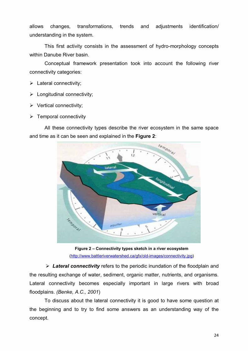
24
allows changes, transformations, trends and adjustments identification/
understanding in the system.
This first activity consists in the assessment of hydro-morphology concepts
within Danube River basin.
Conceptual framework presentation took into account the following river
connectivity categories:
Lateral connectivity;
Longitudinal connectivity;
Vertical connectivity;
Temporal connectivity
All these connectivity types describe the river ecosystem in the same space
and time as it can be seen and explained in the Figure 2:
Figure 2 – Connectivity types sketch in a river ecosystem (http://www.battleriverwatershed.ca/gfx/old-images/connectivity.jpg)
Lateral connectivity refers to the periodic inundation of the floodplain and
the resulting exchange of water, sediment, organic matter, nutrients, and organisms.
Lateral connectivity becomes especially important in large rivers with broad
floodplains. (Benke, A.C., 2001)
To discuss about the lateral connectivity it is good to have some question at
the beginning and to try to find some answers as an understanding way of the
concept.

25
Is the river able to connect with its floodplain (during floods etc.)?
In a natural status the river keep connection with its floodplain especially in
floods time, invading places with its water, new sediments and all its influence.
Former streams become active, small pools are filled up with fresh water; parts of the
ground are covered by new sediments.
Is there a connection between the aquatic and terrestrial (upland)
environments?
In main cases there is a connection between the aquatic and terrestrial
environments by the simple fact that they lay side by side and the water through the
capillarity of the soil ensures a certain degree of moisture that influence the presence
of specific vegetation and animals.
Is there a healthy riparian area?
Riparian area is the interface between land and a river or stream. A healthy
ecosystem is an ecosystem in which structure and functions allow the maintenance
of biodiversity, biotic integrity and ecological processes over time. The lateral
connectivity is a premise of a healthy riparian biome.
Longitudinal connectivity refers to the pathways along the entire length
of a stream. As the physical gradient changes from source to mouth, chemical
systems and biological communities shift and change in response. The River
Continuum Concept (RCC) can be applied to this linear cycling of nutrients,
continuum of habitats, influx of organic materials, and dissipation of energy.
(Watershed Assessment Tool: Connectivity Concepts – Minnesota Department of
Natural Resources)
For example:
A headwater woodland stream has steep gradient with riffles, rapids and falls;
Sunlight is limited by overhanging trees, so photosynthesis is limited;
Energy comes instead from leaves and woody material falling into the stream;
Aquatic insects break down and digest the terrestrial organic matter;
Water is cooled by springs and often supports trout.
In the mid-reaches
the gradient decreases and there are fewer rapids and falls;
the stream is wider; sunlight reaches the water allowing growth of aquatic
plants;
insects feed on algae and living plants;

26
proportion of groundwater to runoff is lower so stream temperatures are
warmer;
the larger stream supports a greater diversity of invertebrates and fish.
The river grows and the gradient lessens with few riffles and rapids
Terrestrial organic matter is insignificant in comparison to the volume of water;
Energy is supplied by dissolved organic material from upstream reaches;
Drifting phytoplankton and zooplankton contribute to the food base as do organic
matter from the floodplain during flood pulses;
Increasing turbidity reduces sunlight to the streambed causing a reduction in
rooted aquatic plants;
Backwaters may exist where turbidity has settled and aquatic plants are
abundant;
Fish species are omnivores and plankton feeders such as carp, buffalo, suckers,
and paddlefish;
Sight feeders are limited due to the turbidity (MN DNR, Healthy Rivers).
To discuss about the longitudinal connectivity it is good to have some question
at the beginning and to try to find some answers as an understanding way of the
concept.
How connected is the river along its length?
The longitudinal connectivity implies that stream (in our case river) should
have a continuously path from the spring to its mouth. This is the natural case.
Is it broken up by dams, weirs or natural obstacles?
This longitudinal continuity could be often tainted by natural and artificial
causes. The main artificial causes are: dams for different purposes (water stocking,
producing energy etc.). Natural causes are more rare and usually are accidentally
(weirs created by thunderstorms by getting down the trees) and not accidentally
weirs created by beavers.
Vertical connectivity is represented by the connection between the
atmosphere and groundwater. The ability of water to cycle through soil, river, and air
as liquid, vapor, or ice is important in storing and replenishing water (Figure 2). This
exchange is usually visualized as unidirectional–precipitation falling onto land and
then flowing over land or percolating through the ground to the stream. An equally
important transfer of water occurs from the streambed itself to surrounding aquifers.
Groundwater can contribute to flows in the river at certain times in the year and at
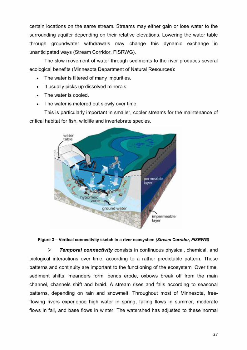
27
certain locations on the same stream. Streams may either gain or lose water to the
surrounding aquifer depending on their relative elevations. Lowering the water table
through groundwater withdrawals may change this dynamic exchange in
unanticipated ways (Stream Corridor, FISRWG). The slow movement of water through sediments to the river produces several
ecological benefits (Minnesota Department of Natural Resources):
The water is filtered of many impurities.
It usually picks up dissolved minerals.
The water is cooled.
The water is metered out slowly over time.
This is particularly important in smaller, cooler streams for the maintenance of
critical habitat for fish, wildlife and invertebrate species.
Figure 3 – Vertical connectivity sketch in a river ecosystem (Stream Corridor, FISRWG)
Temporal connectivity consists in continuous physical, chemical, and
biological interactions over time, according to a rather predictable pattern. These
patterns and continuity are important to the functioning of the ecosystem. Over time,
sediment shifts, meanders form, bends erode, oxbows break off from the main
channel, channels shift and braid. A stream rises and falls according to seasonal
patterns, depending on rain and snowmelt. Throughout most of Minnesota, free-
flowing rivers experience high water in spring, falling flows in summer, moderate
flows in fall, and base flows in winter. The watershed has adjusted to these normal
28
fluctuations, and many organisms have evolved to depend on them (MN DNR,
Healthy Rivers).
The importance of the connectivity
Connectivity is important because it ensures natural river processes continue
to occur (channel maintenance, floodplain evolution).
It is also important because isolated (fragmented) habitats, whether aquatic or
terrestrial, have fewer species (biodiversity), and it is difficult for species to re-
colonize isolated habitats.
Connectivity also ensures there is a flow of energy and nutrients between and
within aquatic and terrestrial (land) environments. For example, in the fall, leaves are
washed into the river and provide important food for aquatic insects.
The connectivity of the river ensures also the ecosystems services. The
ecosystem services are as follows (by the Millenium Ecosystem Assessment
classification):
Provisioning services, the products obtained from ecosystems, including, for
example, genetic resources, food and fiber, and fresh water.
Regulating services, the benefits obtained from the regulation of ecosystem
processes, including, for example, the regulation of climate, water, and some
human diseases.
Supporting services, that are necessary for the production of all other
ecosystem services. Some examples include biomass production, production
of atmospheric oxygen, soil formation and retention, nutrient cycling, water
cycling, and provisioning of habitat.
Cultural services, the non-material benefits people obtain from ecosystems
through spiritual enrichment, cognitive development, reflection, recreation, and
aesthetic experience as well as knowledge systems, social relations, and
aesthetic values.
Connectivity is crucial in the context of restoration. Many reach-scale
restoration projects have been unsuccessful because they were conceived and
implemented in isolation from the larger catchment context (Frissell and Nawa 1992,
Muhar 1996, Wohl et al. 2005 cited by Mathias Kondolf et all). For example, instream
structures used in some restoration projects have not been recolonized because of a

29
limited pool of potential colonizers in nearby intact sites or because of barriers to
dispersal of the colonizers (Bond and Lake 2003). Alternatively, the structure may be
overwhelmed by sediment derived from upstream sources and carried downstream
through the drainage network (Iversen et al. 1991).
(http://www.ecologyandsociety.org/vol11/iss2/art5/)
Classification of Danube River’s Revitalization Project on subclasses.
Methods: Starting from The Los Angeles River Revitalization Master Plan1
developed by City of Los Angeles department of public works were taken and
adapted several standard criterions of revitalization for Danube River, representing
the base for the following 4 criterion subclasses:
- Danube River’s restoration and rehabilitation through Lateral Connectivity;
- Danube River’s restoration and rehabilitation through Longitudinal Continuity;
- Danube River’s restoration and rehabilitation through Temporal Conectivity;
- Capture Community Opportunities & Create Value.
Danube River’s restoration and rehabilitation through Lateral Connectivity
During the last decades, the perception of river-floodplain systems has been
significantly improved by the application of new theoretical concepts (after Ward et
al., 2001, quoted by Buijse A. D. et al., 2002). The ‘river continuum concept’
addresses the longitudinal linkages within rivers (after Vannote et al., 1980, quoted
by Buijse A. D. et al., 2002), while the ‘flood pulse concept’ integrates the lateral
river-floodplain connections in both tropical (after Junk, Bayley & Sparks, 1989,
quoted by Buijse A. D. et al., 2002) and temperate climates (after Bayley, 1991; Junk,
1999, quoted by Buijse A. D. et al., 2002).
In most riverine systems, hydrological connectivity between the Danube River
and its floodplain is restricted to groundwater pathways; geomorphological dynamics
are mostly absent.
This second principle, lateral connectivity, focuses on the goals of developing
continuous. This is linked to an overall network of channels connections that extend
the River’s influence into adjacent neighborhood and provide ways for water
1 www.lariverrmp.org
30
circulation in/out for wetlands. Further, the Lateral Connectivity system develops new
linkages would be created that strengthen the connectivity between riparian systems
along the Danube.
Goals of Lateral Connectivity consist in:
- create a continuous ecological corridor River Greenway, adjacent to the
Danube River consisting of the extension wetlands into Neighborhood;
- connect Neighborhood to the Danube River.
Danube River’s restoration and rehabilitation through Longitudinal Continuity
As a very long-term goal, its ecological and hydrological functioning can be
restored through creation of a continuous riparian habitat corridor within hydro
network of arms and channels and through removal of concrete walls where feasible.
While completely restoring the Danube Valley to a naturalized conditions is not likely
feasible, the restoration projects address to flood control requirements and river
channel could be naturalized in significant areas.
Three goals complement the efforts to restore river functioning ecosystems:
- enhance flood storage - focuses on off- channel storage of peak floods flows
in order to reduce flow velocities, which is a necessary precondition for
ecosystem restoration;
- enhance water quality - seeks to improve the quality of water within
implementation of a comprehensive, landscape-based system for filtering;
- restore the ecosystems functions - aims to restore the natural ecosystems
affected by human activity and restoration of these ecosystems function.
Restaurarea şi reabilitarea Fluviului Dunărea prin Conectivitate Temporală Temporal connectivity is determined by multi-rate fluctuations, affecting the
types of connectivity: longitudinal, lateral and vertical.
Temporal connectivity means the degree to which different bodies of water are
connected in time. Due to variations in volumes, two bodies of water - a main
channel and an adjacent lake - can be isolated over the year, but become connected
in a period of high discharge. Or, conversely, water can become isolated during
periods of drought.
31
Creating oportunities and values
In the past, communities have turned their back on the River, viewing it as an
unsafe, unpleasant place that primarily functions to transport flow and to form a
waterway. Constant danger of floods and the desire to obtain land for urban
development and economic activities insured against flooding works have led to
extensive damming and draining eliminating large areas of floodplains affecting
natural ecosystems. These works had negative consequences for local communities
near the river who have lost identity and traditional occupations.
By restoring lateral connectivity will be created new opportunities for local
riparian communities.
The study will identify these opportunities, how engaging residents in the
community planning process and how:
- engage residents in the community planning process and consensus building;
- provide opportunities for educational and public facilities;
- cultural heritage of the river and foster civic pride.
Creating values Core elements of this principle include the goal of improving the quality of life
by providing new opportunities for traditional economic activities and jobs. River
Revitalization can introduce a broad range of benefits that will enhance Danube
Valley livability and result in greater economic prosperity. Goals encompass:
improve the quality of life;
increase employment;
create an adequate territorial planning emphasis on protecting natural and
cultural heritage, biological diversity and land use of renewable natural
resources directly benefit of local communities.
Cele patru subclase de criterii menţionate mai sus au fost legate de măsurile
preliminare de restaurare şi revitalizare din proiectul FORECAST (Facilitating the
application of Output from REsearch and CAse STudies on Ecological Responses to
hydro-morphological degradation and rehabilitation), pentru a fi analizate în faza
următoare Evaluarea completă a proiectelor de revitalizare a Fluviului Dunărea şi
pregătirea unui Manual cu cele mai bune practici de revitalizare a Fluviului Dunărea.

32
Aceste măsuri sunt clasificate temporar conform cu Agenţia de Mediu din Anglia şi
Ţara Galilor şi Planurile de Management ale Bazinelor Râurilor ţărilor reprezentate în
proiect.
The above mentioned four criterion subclasses were related to the
FORECAST project (Facilitating the application of Output from REsearch and CAse
STudies on Ecological Responses to hydro-morphological degradation and
rehabilitation) preliminary restoration and revitalization measures (Figure 2), in order
to be analyzed in the next phase Comprehensive Danube River’s Revitalization
Assessment and preparation of the Best Practices Danube River’s Revitalization
Manual. These measures are temporary classified according to the Environment
Agency of England and Wales and River Basins Management Plans of the countries
represented in the project.
Preliminary classification of measures after FORECAST project:
to improve water flow quantity;
to improve sediment flow quantity;
to improve flow dynamics;
to improve longitudinal connectivity;
to improve river bed depth and width variation;
to improve in-channel structure and substrate;
to improve lateral connectivity;
to improve riparian zones;
to improve floodplains.
Criteria and General Model for Ecosystem Performance
The general model for ecosystem performance (Figure 4) provides the
general direction with respect to structure and function that the ecosystem is
expected to take on its trajectory toward meeting the project goal. Under a restoration
scenario, the goal is to move the system from a degraded condition to one that is
less degraded and more desirable. For management purposes, it is assumed that
there is a positive relationship between the structure and function of an ecosystem.
The natural structure of an system, habitat, or community has a corresponding
functional condition, and to the extent that this is predictable, this information may be
used to construct the ecosystem performance model.
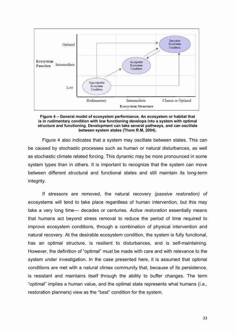
33
Figure 4 – General model of ecosystem performance. An ecosystem or habitat that is in rudimentary condition with low functioning develops into a system with optimal structure and functioning. Development can take several pathways, and can oscillate
between system states (Thom R.M, 2004).
Figure 4 also indicates that a system may oscillate between states. This can
be caused by stochastic processes such as human or natural disturbances, as well
as stochastic climate related forcing. This dynamic may be more pronounced in some
system types than in others. It is important to recognize that the system can move
between different structural and functional states and still maintain its long-term
integrity.
If stressors are removed, the natural recovery (passive restoration) of
ecosystems will tend to take place regardless of human intervention, but this may
take a very long time— decades or centuries. Active restoration essentially means
that humans act beyond stress removal to reduce the period of time required to
improve ecosystem conditions, through a combination of physical intervention and
natural recovery. At the desirable ecosystem condition, the system is fully functional,
has an optimal structure, is resilient to disturbances, and is self-maintaining.
However, the definition of “optimal” must be made with care and with relevance to the
system under investigation. In the case presented here, it is assumed that optimal
conditions are met with a natural climax community that, because of its persistence,
is resistant and maintains itself through the ability to buffer changes. The term
“optimal” implies a human value, and the optimal state represents what humans (i.e.,
restoration planners) view as the “best” condition for the system.

34
II. DIAGNOSIS
Diagnosis is, according to Romanian Explanatory Dictionary (DEX), identifying
a phenomenon based on the description of its current status or the summary of a
state that distinguishes it from others or examination designed to detect errors in a
program. In other words, the diagnosis, referring to the revitalization, is that preoces
that establishes which are the elements that do not meet natural standards and
should be restored to sustainable development.
Diagnosis can be achieved through several means, depending on the
available data regarding both the subject area or system analysis. Further will be
presented several methods for diagnosis methods that were used in different
projects.
A first method is the one that was used in the project Ecological and Economic
Resize of the of the Romanian Danube floodplain Sector (REELD), namely LEAC
(Land and Ecosystem Acounting).
II.1 Methods used in diagnosis
II.1.1 Analyse through Land and Ecosistem Accounting (LEAC)
The first activity within the framework of LEAC analyse, representing “the
study of existing system” trough quantitative and qualitative quantity standardized as
stock raw accounts.
This activity comprise the establishment of general characteristics of analysed
units, especially base function of ecosystems as productive units are able to auto
sustain, total or partial, from energetic point of view and also base material
resources.
The productivity and stability of ecosystems established of support capacity or
possibility to ensure physique support, natural resources and services for
socio/economical systems.
Analysed ecosystems as dynamic systems, unlinear and as productive units, which
dynamic represent a long process where intern variability and diversity are essential
priorities that ensuring the stability and the productivity.
This analyse not leave out the social and economical implications of wearing
away of natural capital takes into account also socio-economical systems following
the same principles.
35
The coherent understanding and the interpretation of complexity and
dynamics of spatial-temporal interactions between human population and nature is
possible through interdisciplinary integration in a frame theoretical model which
permit the identification/ understanding of evolutional and adaptable transformations.
From this view, could be admitted an unforeseeable component of dynamic of
ecological systems. The theoretical arrangement regarding the character of
functional and structural modifications is produced by 4 key- issue (Holling
&Gunderson 2002):
1. Structural band functional modifications in ecological systems aren't
continuously and gradually and even prevalent chaotic. They have an episodic
character, with slow accumulation periods (for example physical structures,
concentrate energy) conked out of sudden changes (release and
reorganisation).
The productivity and stability of ecosystems established of support capacity or
possibility to ensure physique support, natural resources and services for
socio/economical systems.
2. Spatial organisation of landscape is grouped and discontinuous are differing
from connection and breaking up/apportionment point of view. It can
differentiate functional categories of spatial scale, architecture (size, shape,
connectivity) of components which are resulted throughout grouping and
organisation of biotic an abiotic elements.
3. Ecological systems have an unlinear dynamic, among a complex of steady
states circumcised of a stability domain in his turn dynamic. The unlinear
character is given by processes as: reproduction, competition, energy flux,
biogeochemical circuits of nutrients.
4. The policies and management systems which using restricts and immuable
rules to ensuring of constant productions to ecological systems or economical
systems, besides to take into account time and space scale, having as effect
diminish of stability domain or resilience.
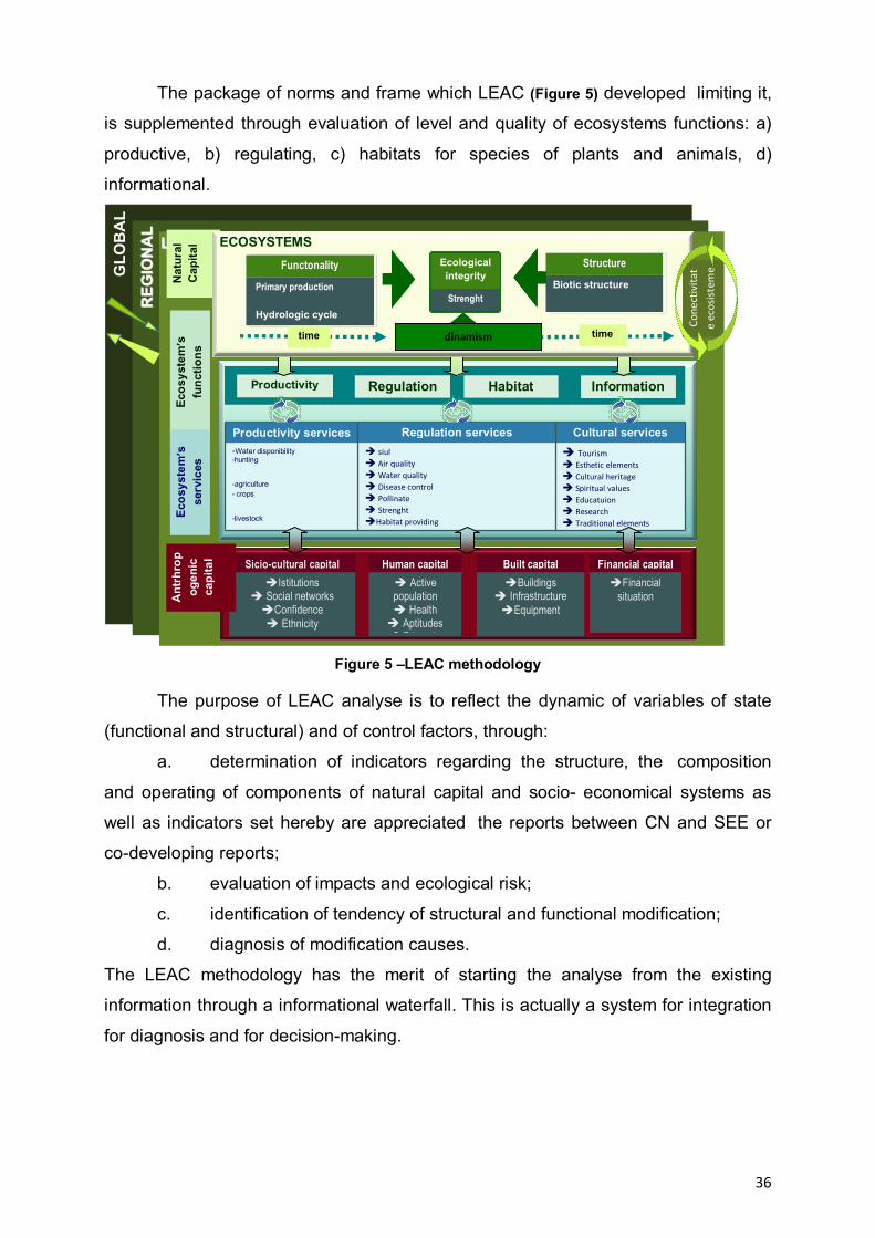
36
The package of norms and frame which LEAC (Figure 5) developed limiting it,
is supplemented through evaluation of level and quality of ecosystems functions: a)
productive, b) regulating, c) habitats for species of plants and animals, d)
informational.
Figure 5 –LEAC methodology
The purpose of LEAC analyse is to reflect the dynamic of variables of state
(functional and structural) and of control factors, through:
a. determination of indicators regarding the structure, the composition
and operating of components of natural capital and socio- economical systems as
well as indicators set hereby are appreciated the reports between CN and SEE or
co-developing reports;
b. evaluation of impacts and ecological risk;
c. identification of tendency of structural and functional modification;
d. diagnosis of modification causes.
The LEAC methodology has the merit of starting the analyse from the existing
information through a informational waterfall. This is actually a system for integration
for diagnosis and for decision-making.
GLO
BA
L
RREE G
GII OO
NNAA
LL
LLOOCCAALL
Ecos
yste
m’s
fu
nctio
ns
Built capital Buildings
Infrastructure Equipment
Financial capital Financial
situation
Human capital Active population Health Aptitudes Educaţie
Sicio-cultural capital Istitutions
Social networks Confidence Ethnicity
Ant
rhro
pog
enic
ca
pita
l
Nat
ural
C
apita
l Ec
osys
tem
’s
serv
ices
Productivity Habitat Information Regulation
Productivity services Regulation services Cultural services -Water disponibility -hunting
-agriculture - crops
-livestock
siul Air quality Water quality Disease control Pollinate Strenght Habitat providing
Tourism Esthetic elements Cultural heritage Spiritual values Educatuion Research Traditional elements
Cone
ctiv
itat
e ec
osis
tem
e Functonality
Primary production
Hydrologic cycle
Structure Biotic structure
Structura abiotică
dinamism time
ECOSYSTEMS
time
Ecological integrity
Strenght
dinamism

37
Starting form the Corine Land Cover maps, the LEAC information waterfall (Figure 6) includes the following stages:
1. Analyse of Stock Raw Accounts phisical stocks (qualitatively and quantitatively)
2. Analyse of Stock Diversity Accounts – dyversity of existing stocks 3. inventory of matter/energy flows 4. Assessement of ecosystems functionality 5. „Natural Capital acccounting
1
2
3,4,5
Accumulation containerof information
Information flux
Information waterfall1 - stock raw accounts2 - stock diversity accounts3 - material/energy flow accounts4 - functional accounts5 - natural capital accounts
Figura 6 –LEAC information waterfall
The first activity within the framework of LEAC analyse, representing “the
study of existing system” trough quantitative and qualitative quantity standardized as
stock raw accounts. This activity comprise the establishment of general
characteristics of analysed units, especially base function of ecosystems as
productive units are able to auto sustain, total or partial, from energetic point of view
and also base material resources.
Analysed ecosystems as dynamic systems, unlinear and as productive units,
which dynamic represent a long process where intern variability and diversity are
essential priorities that ensuring the stability and the productivity.

38
This analyse not leave out the social and economical implications of wearing
away of natural capital takes into account also socio-economical systems following
the same principles.
II.1.2 Analyse based on DPSIR indicators (Driving Force, Presure, State, Impact and Response)
European Agency of Environment based on DPSIR vision (Driving Force
Pressure State Impact Response) has created an ensamble of rules and
methodologies of analisis for diagnosing a system based on existing data, starting
with Corine Land Cover, considering that each clasified unit represents the image
and response to the pocess that take place in that unit – this ansembly was named
Land and Ecosistem Accounting (LEAC).
The many technical aspects of the indicators, which refers to their definition
and usage, selection criteria but also practical aspects, disponibility of using the data,
quality and their collection, their usage in achieveing various objectives and at
various analysis levels, tools of presentation and analysis and also the disemination
ways of the collected data are extremely important in development of the LEAC
metodological package developed by EEA.
At a less detailed level, where inputs and outputs are either not relevant or not
easily identified, the PSR framework is more useful. Instead of focusing on the
different phases of a project, the PSR framework distinguishes between three
different angles of environmental issues:
The pressure variable describes human activities or aspects that exert
pressures on the environment that is the underlying causes of a problem. The
cause can be an already existing one or a new activity or investment.
Examples of potential pressures include income growth, trade patterns and
activities, energy use, and population growth.
The state variable usually describes some physical measurable
characteristic of the environment that results from the pressure. Examples
include indicators that monitor aspects such as water quality, water availability,
deforestation, soil erosion, andexistence and quality of habitats.
The response variables measure to what degree society is responding to
environmental changes and concerns, for example those policies, actions or

39
investments that are introduced to solve the problem. As responses to
environmental problems they can affect the state either directly or indirectly.
In the latter case they aim to influence the pressures at work. Examples include
water-pricing methods, the establishment of resource rents, the use of alternative
crops, and reforestation programs.
The PSR framework (as depicted in Figure 7) is based on a concept of
causality (OECD, 1994): human activities exert pressures on the environment and
change its quality and the quantity of natural resources (the “state” box). Information
about these changes reaches the decision-making instances in society, which
respond through environmental, general economic and sectoral policies.
Figure 7 - The Pressure-State-Response framework
These societal responses strive to result in a change of the human behavior,
which in turn result in an improved state of the environment. While the PSR
framework has the advantage of highlighting these links, it tends to suggest linear
relationships in the human activityenvironment interaction. This should not obstruct
the view of more complex relationships in ecosystems and in environment-economy
interactions. (OECD, 1994) Another critique of the PSR framework is the missing
reflection of how a degraded environment affects human welfare, that is, the
pressure arrow between the “state” box and the “pressure” box could go in both
ways.
The PSR framework has been developed further by various users. One such
development, or change, is the use of driving force indicators instead of pressure
40
indicators. The difference between these two indicator categories is their coverage.
The advocates of the DSR framework claim that pressure indicators are best used for
environmental issues only. Driving force indicators in comparison accommodate
more for social, economic, and institutional aspects. In addition, ‘driving forces’
sounds more positive and can thus be used as explanations to both positive and
negative impacts on sustainable development.
A second development of the PSR framework includes the addition of a fourth
indicator category. Several organizations have therefore chosen to add an indicator
category to the PSR framework. In the PSIR framework, the state indicators have the
advantage to be able to solely focus on the physical measurable characteristics of
the environment, on existing policies (such as water pricing policies), and on
management practices used (for example soil management practices – do the
farmers have leveled soils? Are the irrigation canals lined?). As such the state
indicators explain what factors influence the pressures at work but they also illustrate
the current state of the environment. The category of impact indicators is added in
order to capture the effects the pressures may have on that state. These indicators
would in the PSR framework be included in the category of state indicators, which
may at times give less guidance when the step to decision-making, or responses, is
taken.
Figure 8 depicts an operational cycle using the PSIR framework. The pressures
at work affect the state of the environment resulting in a number of environmental
impacts. For example, chemical use in agriculture may have an impact on the state of
nearby water resources through excessive water pollution. This is both an impact on
the environment per se, but could also risk having human health impacts. To mitigate
the pressure, decision-makers need to have information about the underlying causes
to the farmers’ behavior (and thus the observed pressures and impacts).
Therefore, pricing policies for agro-chemicals, possible subsidies, and crop
patterns, for example, need to be established with the help of state indicators to
create a knowledge on which decisions can be based.
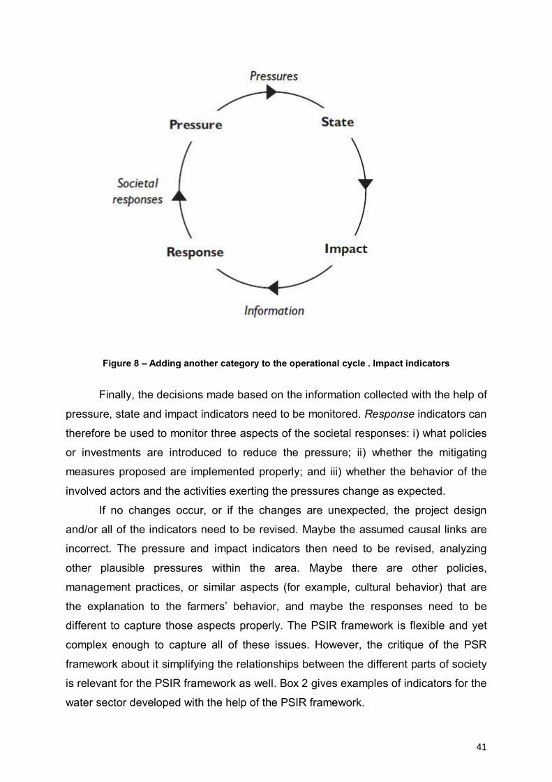
41
Figure 8 – Adding another category to the operational cycle . Impact indicators
Finally, the decisions made based on the information collected with the help of
pressure, state and impact indicators need to be monitored. Response indicators can
therefore be used to monitor three aspects of the societal responses: i) what policies
or investments are introduced to reduce the pressure; ii) whether the mitigating
measures proposed are implemented properly; and iii) whether the behavior of the
involved actors and the activities exerting the pressures change as expected.
If no changes occur, or if the changes are unexpected, the project design
and/or all of the indicators need to be revised. Maybe the assumed causal links are
incorrect. The pressure and impact indicators then need to be revised, analyzing
other plausible pressures within the area. Maybe there are other policies,
management practices, or similar aspects (for example, cultural behavior) that are
the explanation to the farmers’ behavior, and maybe the responses need to be
different to capture those aspects properly. The PSIR framework is flexible and yet
complex enough to capture all of these issues. However, the critique of the PSR
framework about it simplifying the relationships between the different parts of society
is relevant for the PSIR framework as well. Box 2 gives examples of indicators for the
water sector developed with the help of the PSIR framework.
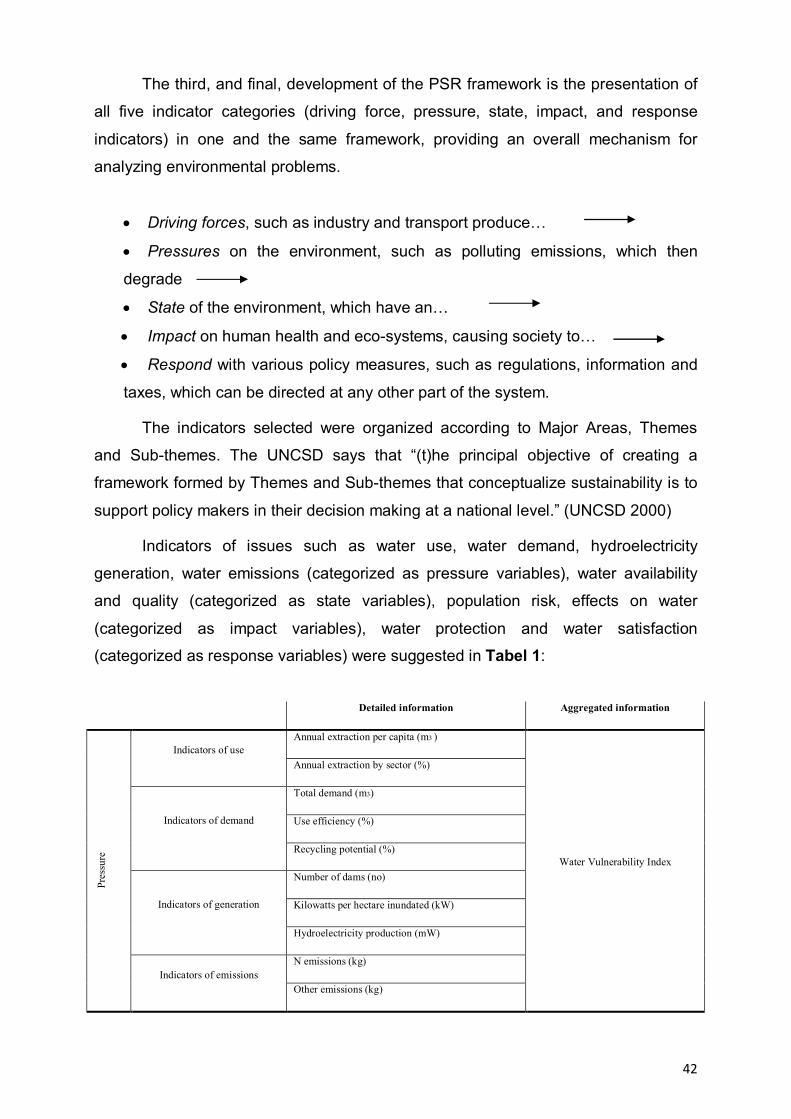
42
The third, and final, development of the PSR framework is the presentation of
all five indicator categories (driving force, pressure, state, impact, and response
indicators) in one and the same framework, providing an overall mechanism for
analyzing environmental problems.
Driving forces, such as industry and transport produce…
Pressures on the environment, such as polluting emissions, which then
degrade
State of the environment, which have an…
Impact on human health and eco-systems, causing society to…
Respond with various policy measures, such as regulations, information and
taxes, which can be directed at any other part of the system.
The indicators selected were organized according to Major Areas, Themes
and Sub-themes. The UNCSD says that “(t)he principal objective of creating a
framework formed by Themes and Sub-themes that conceptualize sustainability is to
support policy makers in their decision making at a national level.” (UNCSD 2000)
Indicators of issues such as water use, water demand, hydroelectricity
generation, water emissions (categorized as pressure variables), water availability
and quality (categorized as state variables), population risk, effects on water
(categorized as impact variables), water protection and water satisfaction
(categorized as response variables) were suggested in Tabel 1:
Detailed information Aggregated information
Annual extraction per capita (m3 ) Indicators of use
Annual extraction by sector (%)
Total demand (m3)
Use efficiency (%) Indicators of demand
Recycling potential (%)
Number of dams (no)
Kilowatts per hectare inundated (kW) Indicators of generation
Hydroelectricity production (mW)
N emissions (kg)
Pres
sure
Indicators of emissions Other emissions (kg)
Water Vulnerability Index

43
Reserves (m3)
Rate of recharge (m3 yr-1)
Annual rainfall (mm) Indicators of availability
Annual extraction as % of total (%)
Biological oxygen demand(mg L- 1)
Chemical oxygen demand (mg L-1)
Eutrophication
Acidification
Stat
e
Indicators of quality
Colibacilli (m L-1)
Water Quality Index
People affected by diarrheic diseases (#)
Population affected by inundation (#) Indicators of availability
Toxicity/ Heavy metal concentration
Population risking inundations (no)
Impa
ct
Indicators of quality Capital risking inundations ($)
Water Quality Index
Watershed land use Indicators of effects
Watershed protected area
Access to potable water (%)
Access to drains (%)
Aqueducts (#)
Treatment of used waters (%)
Res
pons
e
Indicators of risk
Water price (US/m3)
Safe Water Index
Table 1 – Indicators for water sector using PSIR framework
A feature of all of the frameworks discussed in this paper is that they enable
the user to determine whether all concerns (whether they are impacts and pressures
in general or related to specific themes) are being monitored and addressed. A
framework based on sustainable development themes, such as the one used by
UNCSD, can additionally facilitate the identification of core issues for sustainability.
For this reason, this framework is commonly used among organizations that
work on a combination of aspects, such as the ones composing sustainable
development. It is also common for initiatives at the international level where causal
links between, for example, pressures and impacts can be difficult to determine.
There are many more examples of initiatives that prefer to focus on themes rather
than on categories of indicators. The Development Assistance Committee of the
OECD (OECD/DAC) is one organization that used the same type of framework in its

44
collaborative work on a set of indicators for the Millennium Development Goals for
sustainable development.
To select a framework is the first step in working with indicators.
To select a framework is the first step in working with indicators. All
frameworks however, need to have indicators identified for the respective categories,
whether they are project phases, indicator categories, or environmental/sustainable
development themes. The next section introduces a number of selection criteria – a
methodological aspect that needs to be taken into account when working with
indicators (Table 2, Figure 9). Major Areas Themes Sub
themes Major Areas Themes Sub
Poverty
Equity Gender equality
Mortality
Health Drinking water
Health care delivery
Education level
Education Literacy
Housing Living conditions
Population change
Social
Population
Climate change
Atmosphere Air quality
Agriculture
Forests
Desertification
Land
Urbanization
Coastal zone
Ocean, seas and coasts Fisheries
Water quantity
Fresh-water Water quality
Ecosystem
Environmental
Biodiversity Species
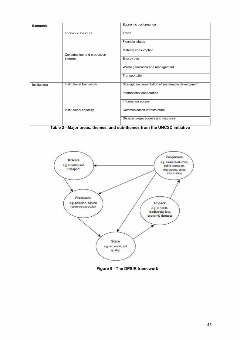
45
Economic performance
Trade Economic structure
Financial status
Material consumption
Energy use
Waste generation and management
Economic
Consumption and production patterns
Transportation
Strategic implementation of sustainable development Institutional framework
International cooperation
Information access
Communication infrastructure
Institutional
Institutional capacity
Disaster preparedness and response
Table 2 - Major areas, themes, and sub-themes from the UNCSD initiative
Figure 9 - The DPSIR framework
46
The purpose of the matrix was to provide the optimum indicators in order to
apply the appropriate territorial Danube floodplain management and available means
to protect natural capital, in the context of sustainable development.
This analyse not leave out the social and economical implications of wearing
away of natural capital takes into account also socio-economical systems following
the same principles.
Environmental degradation and natural capital should be seen as a synergistic effect that has its origins in the failure of the ecological balance of
natural conditions.
Analysis of environmental degradation must lead us to a diagnosis that may
be a preliminary step in formulating the environmental rehabilitation measures.
Evolution of landscapes in the Danube Floodplain under anthropogenic pressure
(forest exploitation, deep transformation of aquatic ecosystems and grasslands) will
lead to obvious decrease in productivity, but also the disruption of functionality and
productivity.
Identification of areas with ecological potential has a determinant role in the
establishment of ecological restructuring measures and calculating environmental
costs.
II.1.3. Multicriteria analysis
The NAIADE (Novel Approach to Imprecise Assessment and Decision
Environments) MCA method developed by Munda (1995) was adopted for a
study, as it offered the opportunity to mange the various types of data to address
the multidimensionality of sustainable tourism. It also allows the analysis of actors
and conflicts using an equity module. NAIADE is a discrete multi- criteria method
whose impact (or evaluation) matrix may include crisp, stochastic or fuzzy
measurements of the performance of a scenario (or an alternative option)
with respect to an evaluation criterion (Munda, 1995).
In summary, NAIADE can provide the following information (i) ranking
of the alternatives according to the set of evaluation criteria (including
compromise solutions); (ii) indications of the semantic distance of the positions
among the various interests groups (i.e. possibilities of convergence of
interests or coalition formations); and (iii) rankings of the alternatives according
to the actors’ impacts or preferences. NAIADE has been widely implemented

47
and compared to other MCA methods (Guitouni & Martel, 1998).
Examples include (i) multistakeholder approaches to waste management in
Surahammar, and (ii) snow management in Sundsvall and stormwater
management in Vasastan, all in Sweden (Kain et al., 2005). Others focussed on
societal issues, such as (i) conflict resolution tool in land-use conflicts in
Netherlands (Munda et al., 1994) and (iii) an approach combining participation
and institutions to address water management issues in Troina, Sicily (De
Marchi et al., 2004).
Implementation of NAIADE requires a number of steps:
a) Generation of alternatives:
To investigate tourism sustainability in the Seychelles, seven sustainability
alternatives were d e v i s e d , o f wh i ch t h r e e i n c o r p o r a t e d adaptation to
climate change scenarios, as summarised in Table 3. Final ranking with the
NAIADE method results in the intersection of two ranking – the φ+ (a) which is
based on the ‘better and much better’ preference relation and with a value going
from 0 to 1 indicating how a is better than all of the alternatives suggested.
Secondly, φ- (a) is based on the ‘worse and much worse’ preference
relation with a value going from 0 to 1 indicating how (a) is ‘worse’ than all of other
alternatives. The next step involves t h e identi f i cation of the evaluation
c r i t e r i a a n d construction of the impact matrix.
Alternative Sustainability implications A Business as Usual Maintain status quo
-discretionary approach to planning and development
-no land-use plans
-inadequate participation & conflict resolution mechanisms
B Strong Conservation Strong Sustainability perspective
-increase protected area coverage ( include outer islands)
-invest economic revenue in maintaining high environment quality
-maintain strict planning approaches
-maintain command & control measures
-precautionary approaches & limit to types/size of economic developments

48
C Intensify economic &
industrial activities
Weak Sustainability perspective
-increase tourism development and density on most beaches &
restrict public access
-intensify tuna fisheries; D Moderate
Conservation policy
including multiple
use areas and defined
Medium Strong Sustainability perspective
-allow limited access to certain protected areas
-implement fisheries rights and quota’s
-improve community involvement in decision-making
-active conflict resolution framework in place E Alternative B +
Adaptation to
Climate Change
External effect on local sustainability
-strengthen/invest in natural ecosystem resilience
-undertake widespread rehabilitation of ecosystems
-strengthen monitoring & reduce local impacts
-change/improve management approaches F Alternative C +
Adaptation to
External effect on local sustainability
Table 3 - Alternative options for sustainable tourism
b) Identification of evaluation criteria: Following discussions with
various stakeholders and considering its relevance to sustainability, an agreed
set of nine evaluation criteria was proposed. These criteria were evaluated
based on environmental, economic and social applicability, as well as use
of quantitative data and qualitative information gathered as part of these
research and other research - Cesar et al. (2004), Payet (2003a), Payet et al.
(2004a), Payet (2004b), and Payet (2005). The nine criteria are briefly described
as follows:
The nine criteria are described as follows:
Environmental Criteria:
i. Conservation Area - Ecosystem loss due to land conversion is an
important indicator of development levels. The issue of land conversion
as a result of tourism development and associated activities is considered
as part of this loss. Permanently lost habitats, such as forests and coral reefs will
affect level of ecosystem services and resilience (Obura, 2005). Changes in
land and use were determined using Geographical Information System
(GIS) tools. Marine conservation areas were excluded from this criterion, as
land area in small islands is usually proportionately very small to sea area.

49
ii. Tourism attractiveness – of the Seychelles is based upon the natural
beauty of the island, its friendly people and personal security. This is an
important cri terion in addressing the issue of pollution and other damages
related to the construction and operation of a hotel (Walker et al., 1999). Climate
change and severe beach erosion may also reduce the attractiveness of tourism
areas. This is considered as a linguistic variable.
iii. Tourism intensity rate – encapsulates the overall pressure brought by
tourism to the coastal zone. It is measured as tourist density in the coastal
zone, according to Harrison (1992). It is computed as the number of visitors
per capita and per square kilometre of total or arable land area.
Economic Criteria:
i. GDP – represents the total value of all goods and services produced by
the economy in a n y g i v e n year. Most expenditure by tourists is regarded
as consumption spending, and imports that are consumed by the tourist’s
results in leakage. Bull (1995:125) l ists the factors that determines tourisms
role in GDP. The data was obtained from the Seychelles Statistical Abstracts
(MISD, 2004).
ii. Total E c o n o mi c Value ( Biodiversity) -the a b s o l u t e value o f
eco log i ca l services, forests, protected areas and other plant and animal
products.
iii. Recreational Benefits (coastal/marine) - This is calculated from welfare
gains in terms of their consumer surplus (WTP), expenditures related to
coastal and marine activities, indirect expenditures (travel & accommodation),
and the multiplier effect on expenditures.
Social Criteria:
i. Precautionary Principle – Current thinking is clearly dominated by the ‘wait-
and-see’ principle rather than the precautionary approach, which call for users to
demonstrate that their actions are not harmful to the marine environment before
they engage in any form of activity (Earl, 1992). This criterion also incorporates
effective implementation of EIA tools and decision-making. This criterion is
considered as a linguistic variable.
ii. Conflict resolution mechanisms – As a linguistic variable it is important to
assess whether such alternatives will permit effective conflict resolution
mechanisms. For example, is it considered that a strong conservation approach
50
will actually engage in higher levels of conflicts that the other alternatives.
iii. Social inclusively (participation/involvement) - In terms of social equity and
stake, participation of all concerned are measured by this criterion. The
linguistic measurement aims to capture t h e par ti cipatory levels i n
implementa t ion of the proposed alternatives.
II. 1. 4 Risk analysis
The risk analysis process requires planners to recognize and communicate the
degree of uncertainty in each planning variable. The sharing of uncertainty
information across a multidisciplinary planning team facilitates the identification of
key variables affecting achievement of the planning objectives. The identification and
inclusion of stakeholders further strengthens the knowledge base [7].
This process elevates risk management decisions from the sole province of the
technical expert to the planning team and decision-makers.
Although the planning process is described in six distinct steps, in practice, these
steps are iterative and often carried out simultaneously; the planning process is not
linear. Planners and analysts work back and forth through the six steps until a
comprehensive picture develops, which is communicated using the six steps as the
reporting outline.
Risk analysis within this context has the same character. The approach for
incorporating risk analysis into the project planning process provides direction
intended to help the planner:
• Identify the levels of uncertainty that are acceptable, at the start of the planning
process.
• Use conceptual and numerical models to communicate the planning team’s
understanding of the ecosystem to others, and reduce the risk of mis-specifying
the system.
• Consider the uncertainty associated with the variables chosen to measure project
effects.
• Use alternative designs to manage identified uncertainty.
• Use risk information to eliminate alternatives with unacceptable risk from
consideration.

51
• Incorporate risk analysis into the USACE four criteria of effectiveness, efficiency,
completeness, and acceptability.
• Use an alternative’s irreducible uncertainty as an attribute to be considered along
with other attributes in the comparison of alternative plans.
• Use risk information in the final plan selection process.
The proposed approach is applicable to ecosystem restoration planning. The
framework is sufficiently flexible to be scaled to projects of any size or budget; the
degree of specification and data-gathering can be tailored to the effort. The
framework can be applied to studies of restoration, creation, reclamation, or
protection alternatives.
This report makes simplifying assumptions to allow a focus on incorporating
risk information in the planning and decision-making process. There are three other
efforts associated with this framework document, which provide the technical detail
needed to develop the necessary statistics. They offer information and guidance for
incorporating risk assessment into cost-estimation, and biological and hydrologic
modeling. The latter two have not yet been published. Three publications are
available regarding costestimation:
Noble et al. [8] is a post-construction analysis comparing project expectations to
outcomes, and Yoe’s reports [9,10] provide guidance and demonstrate cost-
estimation when there is uncertainty. The main idea is to evaluate the risks in each of
the six stages of planning:
1) identifying problems and opportunities,
2) inventory and forecast,
3) plan formulation,
4) evaluation of plans,
5) comparison of alternatives,
6) plan selection.
The conceptual model is introduced in Planning Step 2, inventory and
forecast. In Planning Step 3, plan formulation, habitat modeling methods are detailed.
The fourth section is a brief conclusion, followed by Appendix A, which provides a
fully developed example of a tidal wetland restoration planning process,
demonstrating the application of the approach.

52
In ecosystem restoration, the federal objective is to “restore degraded
significant ecosystem structure, function, and dynamic processes to a less degraded,
more natural condition”. This is further defined in USACE guidance, which states that
“restored ecosystems should mimic, as closely as possible, conditions which would
occur in the area in the absence of human changes to the landscape and hydrology.
Indicators of success would include the presence of a large variety of native plants
and animals, the ability of the area to sustain larger numbers of certain indicator
species or more biologically desirable species, and the ability of the restored area to
continue to function and produce the desired outputs with a minimum of continuing
human intervention. In this report, a conceptual model of the site and landscape is
advocated as a central organizing structure within the six-step process to achieve
these objectives this is responsive to USACE directives that restoration projects be
conceived in a systems context using an ecosystem and/or watershed approach. The
incorporation of ecological tools and concepts into the USACE planning process for
ecosystem restoration is evolving. The conceptual model delineates the empirical
quantities to be addressed in risk analysis and modeling. Thus, this report describes
an integration of concepts and tools from the science of ecological restoration with
proven federal project planning processes. This integration, incorporating risk
analysis into restoration planning, was called for by the USACE Evaluation of
Environmental Investments Research Program (EEIRP).
II.1.5 Stakeholder analysis
In order to ensure an accurate representation of the local situation and the
wishes of local people in relation to the revitalization of the river can be made a
socio-anthropological rigorous investigation by specialists. The socio-anthropological
survey mentioned above through specific methods (tree approach - from identifying
the parties involved in order to implement the Focus Group method and / or semi-
structured interviews) is not at the empirical level, but committed a theoretical point of
view - a pragmatic approach on both the social and basic research regarding
revitalisation.
From the previous projects experience: Integrated Management of European
Wetlands (IMEW), Master Plan for Master Plan - support for sustainable development
in DDBR Tulcea county/ Romania Logical Framework Analyse (LFA), Ecological and
Economical Resizing in Romanian Sector of Danube Floodplain (REELD), Room for
53
the River in Cat’s Bend, Romania, DDNI specialists will provide a good sample of
methodology for identification and analysis of stakeholders involved in flood risk
management, from the following general objectives:
To identify stakeholder institutions, to include local, regional, national and
international bodies relevant to the flood risk management of each site;
To identify the ways in which formal and informal institutions interact to affect the
relationship between floods, land use and local communities;
Assess the extent to which the management and use of resources acknowledge
local needs.
Objectives 1 and 2 required the collection of empirical data from a wide
selection of groups. Is necessary to adopt methodologies that are appropriate to
each of the local sites and the results must to be comparable. It is important to
better understand how attitudes and practices of different institutions to respond to
the following questions:
1. How does the management of floodrisk and land-use acknowledge local needs?
2. How do local, regional, national and international bodies interact to affect the
relationships between local communities, their livelihoods, land-use and floodrisk?
3. How does the management and spatial planning affect household livelihoods?
The objective of the first stage of the work was to identify both the formal and
informal institutions that affect the management of the Galati site. This stage involved
collecting data from formal institutions (including the laws and regulations associated
with them) and the learned patterns of behaviour, norms and informal rules (informal
institutional structures) that govern wetland site management. There are three
aspects to this exploratory stage:
identification
relative significance to the interviewee
relative power of the institution
Methodology. Must be carried out with key local informants from different social
groups, and organisations identified by the interviewer, scientific and educational
institutes, NGOs, environmental charities, local government and community
organisations. Try to capture a broad range of people, e.g. of different ages, gender
and different backgrounds. Also to make sure that was covered a wide enough
geographical area to capture any variation.
54
The key question that we answered at this stage was: ‘’What organizations affect
the risk management?’’
Rezults: The preliminary investigation will provide a list of stakeholders
affecting the risk management.
Identifying the way in which formal and informal institutions affect the river
revitalization.
In this stage must uncover the complexity of the management institutions
affecting the proposed site. The empirical research was carried out with the
stakeholders identified above. We saw this as falling roughly into two different groups
of work:
the formal institutions, the organizations or bodies that have an interest in this
site, and the ways in which they govern the site. Much of the material to be collected
from them will be written up in regulations, guidelines etc. and will be found by
searching through archive and written resources. With this group the key to our
understanding is determining how these written regulations are interpreted and
applied in practice.
informal aspects of the situation at the case study. In this case the same
procedures apply as above. In this category you might find for example, established
patterns of rights of ownership or use that are not recorded - these may change
seasonally - , there may be systems that only come into being in times of crisis, such
as a drought, low water level, there may be some things that women do and some
things only men do.
The methodology used for this part of the research is based on one hand on
literature, current legislation and on the other hand on focus groups or semi-
structured interviews. It is important that you capture geographical spread and the
variation within communities. We should aim to cover all the main stakeholder
institutions and organizations.
For the smooth running of the survey is very important to conduct pilot
interviews in each area. Data from these will be evaluated in terms of research
objectives, and will note any problems that arise, such as: policy discussions,
disagreements, contradictions, or what is irrelevant.
55
Also, all the difficulties and successes in carrying out work on practical aspects
are reported. On this basis, the methodology will be adjusted and adapted. Thus, the
research methodology used is improving, until satisfactory results are obtained.
Although it seems time consuming, these methods are important for sociological
research because it is one of the ways we can ensure the validity of results. In
individual interviews with citizens will be designed a schematic overview of the issues
explored during the interviews. This is a list of questions, but an "aide memoire" to
help develop comprehensive interviews.
The results of interviews and focus groups will be analyzed using qualitative
methods.
III. DIMENSIONS OF DOCUMENTATIONS AND ANALYSIS
III. 1 Spatial dimension
River revitalization approach must take into account the scale at which the
process impact. So important are three levels to analyze the impact that has to be
quantified rigorously, namely: the first level is the highest if the system is envisaged
as a closed system is River Basin, next level is the regional level that includes
several types of water and / or countries, and the third is the local level that has a
much smaller expansion beeing limited to only a certain type of water in a single country.
III.1.1 River Basin Level
It represents the maximum scale at which can be adressed the Rhibe River as
a closed system. Treating it as an open system the scale can be much wider
reaching the continent level or even global scale. An example of a basin level
approach will be presented below:
Rhine Integrated Plan
Prior to the 19th century, the River Rhine was still a wild river by and large
untouched by man. Subsequent human intervention strongly altered the stream and
resulted in a loss of floodplains. This increased the exposure to flood hazards. The
first correction of the River Rhine was carried out between 1817 –1880 according to
master plans by Johann Gottfried Tulla, engineer and lieutenant colonel in the former
duchy of Baden. For this purpose, numerous channels of the river in the furcation
zone were combined to form one main bed with a width of 200 m to 240 m, while the
56
wide meander loops were cut through. As a result, the Rhine received a new riverbed
which has essentially remained the same until today. The length of the Rhine section
between Basle and Worms was reduced from 354 km to 273 km.
All in all, the correction of the Upper Rhine resulted in a major loss of natural
wetlands and brought about a reduction in the frequency of floods in the areas
bordering the river. The mere construction of the dam between Märkt near Basle and
Karlsruhe entailed a floodplain loss of 660km2. The increased erosion of the Rhine in
the South brought about the loss of another 80 km2 of floodplains.
Risk. The total damage resulting from a major flooding (1 in 200-year flood) in
the Upper Rhine plain between Iffezheim and Bingen is estimated to amount to more
than 6 billion euros. Moreover, it is expected that such an event will also result in
human casualties.
The cause. Until the 70s prior to the construction of the dams on the Upper
Rhine between Kembs and Iffezheim, the situation proved to be less dramatic. At that
time, the number of natural floodplains along the southern section of the Upper Rhine
was still sufficient, allowing the retention of water while reducing the river flood
conveyance along the northern stretch of the Upper Rhine to an acceptable level.
With the construction of the dams, the floodplains were cut off from the natural
discharge regime of the Rhine.
The solution. Raising the dams along the vulnerable section of the Upper
Rhine beyond their current height must be ruled out in terms of a potential solution to
the problem. Thus, the only feasible solution to attenuate critical flood peaks
embraces the creation of floodplains. On the Upper Rhine, there is still a possibility of
doing so in quite a number of areas. In former times, prior to the construction of the
dams, these areas were always subject to inundation; today, they are mainly used for
forestry purposes, with a small proportion set aside as farmland.
Therefore the main objective developed by the Integrated Rhine Programme
(IRP) involves restoring natural hydrologic functions and ecological restoration of
these forest and agricultural areas.
Implementation and sustainability of the plan. According to current estimates,
the costs of implementing the plan amounts to 775 million euros, while the costs of
losses because of floods rises to 6 billion euros plus a potential human losses.
Besides the financial benefit there is a natural one, increasing the number of
57
wetlands that are natural habitats that were once typical to Superior Rhine. Also the
financial basis for the local population will be ensured, having as a results creation of
opportunities and social and cultural values.
Rhine Integrated Plan (RIP). The goals pursued by the Integrated Rhine
Programme include flood control as well as the preservation and/or restoration of
theUpper Rhine plains. Following the example given by nature, today’s floodplain
protection is tomorrow’s flood control. The Integrated Rhine Programme proposes
the creation of flood retention areas at 13 sites located in the alluvial floodplains on
the Baden-Württemberg side of the Rhine. Moreover, it aims at achieving the
preservation and restoration of the alluvial floodplains on the Upper Rhine to the
largest possible extent. According to the present framework concept pertaining to the
Integrated Rhine Programme, this would require a retention volume of approximately
167.3m m3 on the Baden-Württemberg side of the Rhine. Essential elements for
ensuring environment- friendly flood control are the preservation and creation of
semi-natural floodplain biotopes.
The successful implementation of the Integrated Rhine Programme depends
on a multitude of individual measures. Today, three out of a total of 13 planned IRP
flood retention areas are completed. Two of them, the Altenheim Polder and the
cultural weir near Kehl/Strasbourg have successfully operated for almost 20 years
now. The Söllingen/Greffern Polder was brought to completion in 2005 and the
Rheinschanzinsel retention area is under construction. Over the next years, further
flood retention areas will be built. The Integrated Rhine Programme can only be
implemented when all stakeholders join forces and take joint action. In the long run,
these efforts will pay off. The Upper Rhine plain will benefit from the floodplain
biotopes and their high level of species and structural diversity. At the same time,
flood hazards are mitigated. The IRP is the prerequisite for the reduction of losses
generated by extreme flood events along the Upper Rhine.
III.1.2 Regional Level
It is a very important level because gathers on the one hand some of the
details of larger scale or local level on the other side. Most recent example of the
River Danube's approach to such a level is the Ecological and Economical Resize of
lower Danube floodplain, Romanian sector (REELD).
58
REELD ojectives:
- reconsideration of the activities from polders in accordance with cost/benefit
ratio for investment and to maintain defense dykes and other hydrotechnical works;
- establishment of directional flooding regime at high levels;
- determining the regime of flooding in polders Bistreţ, Potelu, Suhaia, Greek,
etc. Calarasi., for their renaturation and revitalisation.
Recent wetlands reductions are, mainly due to agricultural development
through damming. This reduction takes place also through the drainage of land, or
regularization of rivers (Barnard, WD et al., 1985).
Human activity affects the stability of a wetland by many mechanisms. One of
these actions is deliberate intervention by improving drainage of agricultural land to
extend the exploitation of peat for fuel. Such interventions have attracted public
attention, especially by coverage of the danger of loss of habitat for many species
that depend on the existence of these areas.
Yet little attention has been given to indirect impact of human activities on the
stability of organic deposits by increasing the Greenhouse Effect (Dean, JV and
Biesboer, DD 1985). The greenhouse effect leads to global warming and precipitation
reducing. Reduced rainfall may seriously affect the stability of the peat deposits of
wetlands by aerobically longer processes determined by lack of water layer.
Microbiological and enzymatic degradation of the peat deposits lead rapidly releasing
into the atmosphere of carbon dioxide, with direct effect on the growth of greenhouse
effect and potential impact on global climate change.
For the Danube floodplain, hydrological factor characteristics change had the
following consequences:
Land is getting arid and soil salinization increasing;
Reducing water exchange with the surrounding areas;
Reducing habitats for birds;
Changing major vegetation structure and composition;
Blocking the movement of fish in neighboring areas to the site where they
provide optimal breeding;
Loss of organic matter by mineralization;
Stop filtering role of sediments and nutrients, which came with floodwater.

59
Thus, in the given circumstances, the best option is to use strict wetlands
policies on the Lower Danube Plain, followed by a well prepared monitoring system
alert and a series of advanced tools for exploring the strategies and policies to
address to detected threats. With increased effort exerted on the system and the
complexity of the issues, the need for planning tools is changing rapidly.
With particular importance to planning issues are the following three aspects:
- Systems should be considered as a whole. So while a manager intervenes directly
only in a limited part of the system, the consequences of these policies will send links
to other parts of the system. It is possible that the problems facing the manager to
have originated in actions that took place in other parts of the system to solve other
problems simplistic.
- Second, human systems and natural systems are dynamic and constantly evolving
but never in equilibrium. Therefore, managers intervene in system change in a
certain critical point; the consequences of small interventions can be of great
importance.
- The third aspect is that these systems are inherently spatial. The consequences of
planning policies depend on the context of spatial planning that are implemented and
how that changes the context.
Ecological and Economic Resizing Program for Romanian Sector of the Lower
Danube floodplain will have to provide a spatial planning tool (IPS), developed in
accordance with the three features, and built to design, analyze and evaluate long-
term policies in a social, economic and environmental.
The main goal of IPS is to explore the effects of alternative policies on the
quality of socio-economic and natural environment, and with this information to
stimulate and facilitate conscious actions, discussions, before taking decisions
(public debates).
IPS should not seek to optimize the economic, ecological and social, but
rather to maximize the whole. Although this implies a loss of detail, the side benefit of
this approach is strong integrative system resulting in autonomous processes play an
important role.
Current policies and proposed actions perform against stakeholders on the
free market and can be introduced into the IPS with the help of maps and zoning
controls that behave like independent constraints on the autonomous dynamics of
the system.

60
The main component of the IPS has to be a dynamic model of land use
applied to the entire territory of the Lower Danube floodplain. To represent the
processes that develop and change the layout of the Lower Danube floodplain
requires a model to represent processes superimposed on three geographical levels:
national, regional and local levels.
Regional development has become a major concern in the last decade of
study for scientific research and debate for central and local authorities, the
entrepreneurs and the public. Area - in support of human activities and natural capital
- is objective and universal form of material existence, which looks like a continuous
whole and express the real world order of coexistence. In the space-time, material
movement takes place. In human existence, the space is defined as a dual meaning
for the survival of biological condition, considering it as a resource that explains the
role of the area played in human history, but also need psychological space is
perceived as liberation from the constraints and dangers.
Anthropocentric perspective, examining space according to the cultural
support - from experience, and relationships with others, people organize the space
to suit their needs and social relations.
In the particular area - such is the case of wetland, spatial skills starts from the
instinctive awareness of space, in a subjective way, giving well-defined value
hierarchy. Spatial dimension is vital to support socio-economic system (SSE):
apparently gives us space, mobility and experience. Chain of internal structures
through cultural and political criteria, the geographic area physically creates quality
geographic landscape - and the elements of surveying SSE urban integrated
geographic area are directly related.
Natural Capital of the Lower Danube floodplain has a productive capacity to
be known by its functional cells to prevent degradation, de-structuring under
anthropogenic impact and promote sustainable use of its support capability. Ensure
sustainable socio-economic development of the Lower Danube floodplain area is
also based on knowledge ecological sustainability (durability) integrity of ecosystems,
environmental carrying capacity, regional and local ecological balance of
ecosystems.
Biological diversity, ecosystem function and naturality of the Lower Danube
FloodPlain is a consequence of their evolution over time and of the succession of
different "civilizations" that have disturbed the balance of the original environment.

61
The desire to understand the crisis of nature "is understandable for this
geographic area, in which were defined separately the natural units. Lower Danube
Plain, by its geographical position and its time history is an area with diversity in
landscapes, ecosystems, beeing characterised by heterogenity, spatial and temporal
dynamic of human. Space and habitat management, particularly in the Lower
Danube floodplain requires finding ways and means of protection, conservation and
social management of ecosystems and landscapes.
Recent evolution of Lower Danube Floodplain landscapes under
anthropogenic pressure (natural resources exploitation, intensification of built land
against natural ecosystems, the profound transformation of grasslands or aquatic
ecosystems) leads to the obvious decrease in productivity, but also the disruption of
their functionality and productivity.
Pan-European strategy for maintaining biodiversity and ecosystem
functionality (Nowicki, 1996) has clear objectives, among which, for Romania and
Danube Delta, awareness and participation of local communities (social management
in our definition) should play a very important role.
In the taxonomic scale developed by Richard J. 1975 the ecological
equipotential area corresponds to GEOTOP. Using analytical maps involves an initial
assessment of the hierarchy of categories of environmental equipotential areas. After
a correlation of these equipotential units with the land exploitation the following
conclusions can be retained:
- Diversity of environmental types and subtypes requires temporal and spatial
dynamics of equipotential ecological areas
- Changes in land use have modified the quality of environment equipotential
units; in this regard were analyzed the areas with human intervention flooding (AP)
forest by planting alien species in relation to the original vegetation
The landscape is defined as "portion of the space, characterized by a dynamic
combination so unstable physical , biotic and anthropogenic elemnts which are
reacting between them, forming territorial units-landcspes, which evolve as one, both
under the effect of constituent components and under the dynamics effect of each
separately "G. Bertrand (1968). The same author states that lanscapes’s individuality
is based on interaction between established three main components: the
environmental potential 9ecological support), the biological exploitation (communities

62
living organism) and the antropogenic (social work). They endure the dynamics of
coomon geo-system physical expressed by a particular type of landscape.
Often, the dynamics of a component element may be different from al the
dynamics and then, changing relationships between components, requires a new
dynamic trend expressed by altering the landscape. Geo-systems may evolve
between the three states defining: the biological exploitation (relationship between
components imbalance caused by natural causes or anthropogenic), anthropogenic
(imbalance relationship between constituents and the relationships among these
having an artificial effect by anthropogenic activities) respectively ecological support
(balance between relations support the operation of biological and ecological stability
of morphology-structural components), they cause environmental degradation
support and /or biological exploitation, effects are forwarding, then each other
between all the components.
Was conducted a wide study of the Danube plains as well as on each of its
natural units and were thus distinguished 13 areas, namely:
-Natural Unit Turnu Severin – Gruia
- Natural Unit II Gruia - Calafat
- Natural Unit III Calafat – Jiu
- Natural Unit IV Jiu – Corabia
- Natural Unit V Corabia – Olt
- Natural Unit VI Olt – Zimnicea
- Natural Unit VII Zimnicea – Pietrosani
- Natural Unit VIII Pietrosani – Giurgiu
- Natural Unit IX Giurgiu – Arges
- Natural Unit X Arges – Calarasi
- Natural Unit XI Calarasi – Harsova
- Natural Unit XII Ialomita – Siret
- Natural Unit XIII Siret – Ceatal Ismail
Analyses carried out allowed the identification of areas in biostazie (phase of
stability in landscape evolution due to absence of erosion, where there is a
vegetation layer) present all over the unbanked Danube floodplain; areas in
rhehistazy that are represented by urban / rural areas; areas in parastazy (instability
in landscape evolution due to erosion in the absence of a permanent vegetation
layer) - characteristic for agriculture areas. The map made by the European
63
Environment Agency - CLC200, on land cover areas were identified three stages, as
follows: 1-artificial territories are territories in rhexistazy, 2 - territories with agricultural
use are in parastaziy 3 - Lands forests and semi-natural areas, 4 - Wetlands, 5 -
water surface areas were considered in biostazy. Thus was created equipotential
map of which areas were statistically analyzed.
III.1.3 Local level
Involves a small portion of Danuve or a a tributary of the Danube that is
under investigation for possible ecological restoration and revitalization. They usually
focus on a very small area or a very short stretch of the Danube River or its tributary.
Further, revitalization projects will be presented which were conducted at the local
level
The Danube restoration project between Neuburg und Ingolstadt (Germany)
Projetc’s summary:
The study area is the Danube River between Neuburg and Ingolstadt. Along
the study area since the 19th century there were a lot of changes regarding the river
course. In the 1970s two additional hydropower station (Bergheim in the west and
Ingolstadt in the east) were built. Due to these changes occurred in the past, today
typical floodplain habitats are highly endangered. In the last 150 years 75% of the
Bavarian floodplain areas were lost due to human activities (after Margraf, 2004,
quoted by Stammel, 2008). In the study area, however, 2100 ha of riparian forest and
riparian habitats have survived as relicts of the former floodplain. (Stammel, 2008)
Bulgarian Wetland Restoration and Pollution Reduction Project (RIVER
ENGINEERING) (Bulgaria)
Projetc’s summary:
MWH carried out the river engineering project for the restoration of Belene
Island and the Kalimok/Brushlen wetlands on the Danube River for the Bulgarian
Ministry of Environment and Water under a WB Financing.
The project assisted Bulgaria in meeting its international commitments in
relation to the Strategic Partnership for reduction of nutrient pollution in the Danube
and the Black Sea basins and the relevant requirements of the Convention for
Protection of the Danube, the Convention for Protection of the Black Sea etc. All
these activities are carried out in close cooperation with the local communities
(Nikopol, Belene, Svishtov.Tutrakan, Slivo Pole), the Belene Island prison

64
administration, RIEWs (Pleven, Veliko Tarnovo, Ruse), the Executive Environmental
Agency, state forestry boards in Nikopol, Svishtov, Tutrakan and Ruse, scientific and
academic institutions, non-governmental organizations etc.
The LIFE Project “Upper Drava-river valley” Austria
Projetc’s summary:
The upper Drava in Carinthia in Austria is a typical Alpine river which hosts the
last remnants of inner alpine floodplain forest associations and endangered species
populations such as the Danube Salmon (Hucho hucho). The alder-ash floodplain
forests are the best preserved and largest ones in the entire Alps. It is one of
Austria’s largest rivers which have being preserved as a free-flowing river on over 60
km without any dams.
The main objective of the LIFE project was to maintain and improve natural
flood protection and the river dynamic processes and therefore to improve natural
habitats and typical species populations. This was achieved through restoring three
ecological “core zones” by river bed widening and reconnection of the former side-
arm system with the main river of over 7 km of its length. An additional focus lay in
the restoration of the natural floodplain forests, the protection of endangered species
and the creation of a combined biotope system along the whole river valley.
The LIFE Project „Wild river landscape of the Tyrolean Lech” Austria
Projetc’s summary:
The Lech in northern Tyrol is characterised by huge gravel banks and broad
areas of lowland riparian forest. It is the last major river in the northern Alps that is in
a semi-natural state. For over 60 km, the highly braided river occupies a gravel bed
that in parts is up to 100 m wide. The course of the river is constantly changing due
to erosion and deposition.
The main objective of the LIFE project is to restore characteristic habitats of
the Lech River by widening the riverbed of over 6 km of its length. In the widened
sections about 35 ha of new gravel banks are going to be created which increases
endangered species populations. At the same time the supply of gravel to the main
river channel is being increased by gradually removing the debris dams in the
tributaries. This would mean using the ecological approach for stopping further
deepening or even raising of the riverbed. The project is being accompanied by
species protection as well as visitor management measures.

65
Monitoring results of revitalization measures on an urban lowland River
(Liesingbach, Vienna, Austria)
Projetc’s summary:
The Liesingbach, flowing through the south of Vienna, Austria, is an urban
stream that has been designated as a heavily modified body mainly because the river
was canalized, its bed was hard and the water quality poor due to considerable
wastewater discharge. A study in 1999 before the restoration confirmed the poor
ecological status in terms of hydromorphology, aquatic biocoenosis, riparian
vegetation and water related terrestrial fauna. Until 2005, a 5.5 Km long reach close
to the south-eastern city limit was revitalized with the intention to induce an
ecological development by improving the hydromorphological conditions. However,
the creation of a typical lowland river morphology was limited due to the difficulties in
acquiring adjoining premises. The implementation of the European Water Framework
Directive into national legislation gave rise to an interdisciplinary assessment of
realistic development objectives for an urban river like the Liesingbach.
Consecutively, the Liesingbach was classified as a heavily modified water body.
River Wien restoration project: improvement of the ecological condition of a
heavily modified river in a urban environment (Austria)
Project summary:
The Wien River has its source in the Vienna Woods, to the west of Vienna,
Austria, at 620 m ASL. With a length of 32 Km and a catchments area of 230 sqKm,
it is, beside the River Danube, the most important river passing through the city of
Vienna. The catchments area mainly consists of flysch with a very low pore volume
and a low water retention capacity. Rainfall therefore leads to high surface runoff and
an immediate and strong rise of the discharge of the Wien River. For flood protection,
the river was placed in a deep channel in the late 19th century and the river bottom
was sealed with paving stones and concrete.
LIFE Nature Project Wachau of dry grasslands and Danube nase (Austria)
Projetc’s summary:
In the LIFE Nature Project these particular habitats are maintained by re
moving bushes and mowing grass cover. Grazing with Waldschaf sheep prevents
open spaces from becoming overgrown. The focal areas for dry grassland
66
—
management are in the communities of Dürnstein, Rossatz-Arnsdorf, Spitz and
Weissenkirchen. The Arbeitskreis Wachau group cleared and recreated over 50
hectares of overgrown dry grassland and meadow. Recurrent land management
procedures were carried out on a further 100 acres.
The LIFE Nature project, in collaboration with the municipality of Mautern, has
taken the semi-natural forest around the Ferdinand-Warte look-out point near
Unterbergern out of utilisation. Forest protection areas covering almost 160 hectares
have been established, in collaboration with the Rossatz agricultural association and
the communities in Rossatz-Arnsdorf and Spitz. These untreated areas form the
habitat for many endangered bird species such as the black stork, white-backed
woodpecker, red-breasted flycatcher and many more. Old and deadwood are
necessary for the survival of endangered beetles such as the Great Capricorn beetle
and the stag beetle.
Lobau (Austria): reconnection at floodplain
Projetc’s summary:
The improved connectivity between water bodies at higher mean water levels
in the floodplain has decreased the risk of massive eutrophication events, improved
the water levels in small oxbows and some semi-aquatic areas, and conserved the
existing species diversity in aquatic habitats (after e.g. Bondar-Kunze et al., 2009,
Funk et al., 2009, Sommerwerk N. et al., 2010).
National Park Donau – Auen (Austria): side arm restoration and river bank
restoration
Projetc’s summary:
To enhance riverine morphodynamics, several sidearms have been
reconnected since 1995 (Rkm 1905.0-1906.5; 1905.2-1902.0; 1910.1-1906.5) and
since 2005 river embankments and grayness have been removed from 2.85
kilometres (Danube Rkm 1885.75-1882.9) and from 1.2 km (Danube Rkm 1883.1-
1881.9). The long-term goal of the project is to come as close as possible to the pre-
regulation status of this Danube section. Implementation is by the Austrian Waterway
Agency (via donau) and Danube Floodplain National Park subsidized by the EU
LIFE-Programme.

67
Morava River (Slovakia and Austria): reconnection of meanders
Within the project GEF-Biodiversity four cut-off meanders were partly
reconnected to the river between 1993 and 1995 (Morava-Rkm 12, 19, 65). The aim
was to increase the flow dynamics in the former anabranches. The bypass-canals
stayed fully active, water inflow to the re-opened meanders was limited by rock dams.
LIFE05NAT/SK/000112 „Restoration of the Wetlands of Zahorie Lowland“
(WETREST) Slovakia
The project area consists of eight wetlands – Sites of Community Importance
that are located in the area between the district cities of Malacky and Senica (west
Slovakia). Four of them – Rudava, Orlovské vŕŝky, Meŝterova lúka and Kotlina – are
situated within Zahorie Military District. Rudava is also designated as an
internationally important wetland (Ramsar site) according to the Ramsar Convention.
Krapje Djol (Croatia): reflooding of oxbow
During the implementation of the UN-World Bank SAVA 200 program the site
suffered as its surroundings were drained in a polder, large flooded pastures were
transferred to arable land and herbicides delivered by airplane directly over the
colony. A ditch drained the water from the oxbow and the site dried out in 1989 (after
Dezelic and Scheider-Jacoby, 1999, Sommerwerk N. et al., 2010).
Camenca river restoration (Moldova) – Lessons learned for river restoration in
the eastern part of the Danube River Basin
The Camenca River represents a heavily modified watercourse. The channel
constructed in the 70s dried the wetlands from the lower part of the river and reduced
the river discharge into the Prut river. The channel length is shorter with 7 Km than
the natural course (50-60 Km length). Dried lands were used for agriculture
purposes, and the surface covered by water was reduced up to 90 %. (Drumea,
2008).
Ecological Restoration in the Danube Delta Biosphere Reserve (Romania) –
Babina and Cernovca islands
The study areas are the islands of Babina and Cernovca situated in the north-
east of the Danube Delta. The reason for dyking and drainage on the islands was the
intention to transform swampland into arable soil. All typical and traditional forms of

68
land use, including fishing and reed harvesting, were eliminated. Before they were
dyked, both islands had a water network which regulated their hydrological balance.
Due to embankments the vegetation of the islands was submitted to dramatic
alterations.
Research for ecological restoration in the Dunavat-Dranov region, Danube
Delta (Romania)
The aquatic ecosystem of one of these former fish-ponds, namely Holbina II,
was observed to change during the mid-nineties from a highly diverse mesotrophic
state to one of turbidity with low natural value. The objective of this report is to
summarize all research related to the ecological restoration of these fish-ponds, in
particular Holbina II, conducted over the past decade. Based on this review, some
recommendations have been formulated. Holbina II is, in common with the other fish-
ponds, surrounded by a dike and almost isolated from Danube river water.
III.2 Typological dimension
Water typology. Given that the Danube River Basin covers an area of
significant amount of the entire European continent, which determines the existence
of a rich diversity in types (morphology) of river tributaries (regardless of their order),
but the river itself requires a systematization of the research in question the river
revitalization.
To gain first hand information on the reconstruction of the Danube River Basin
areas or along the river should consider the following two aspects: first is the scale at
which the ecological reconstruction taking into account the impact of it, and the
second is the type (morphology) of the tributary or even the Danube River sector
where renaturation occurs.
River morphology (at least for the European continent) is stipulated in an
official document: the European Water Framework Directive.
III.2.1 Surface water. Characterisation of surface water body types
Member States shall identify the location and boundaries of bodies of surface
water and shall carry out an initial characterisation of all such bodies in accordance
with the following methodology. Member States may group surface water bodies
together for the purposes of this initial characterisation

69
(i) The surface water bodies within the river basin district shall be identified as falling
within either one of the following surface water categories . rivers, lakes, transitional
waters or coastal waters . or as artificial surface water bodies or heavily modified
surface water bodies.
(ii) For each surface water category, the relevant surface water bodies within the
river basin district shall be differentiated according to type. These types are those
defined using either system A. or system B.
(iii) If system A is used, the surface water bodies within the river basin district shall
first be differentiated by the relevant ecoregions in accordance with the geographical
areas identified in section 1.2 and shown on the relevant map in Annex XI. The water
bodies within each ecoregion shall then be differentiated by surface water body types
according to the descriptors set out in the tables for system A.
(iv) If system B is used, Member States must achieve at least the same degree of
differentiation as would be achieved using system A. Accordingly, the surface water
bodies within the river basin district shall be differentiated into types using the values
for the obligatory descriptors and such optional descriptors, or combinations of
descriptors, as are required to ensure that type specific biological reference
conditions can be reliably derived.
(v) For artificial and heavily modified surface water bodies the differentiation shall be
undertaken in accordance with the descriptors for whichever of the surface water
categories most closely resembles the heavily modified or artificial water body
concerned.
(vi) Member States shall submit to the Commission a map or maps (in a GIS format)
of the geographical location of the types consistent with the degree of differentiation
required under system

70
III.2.2. Ecoregions and surface water body types
III.2.2.1.Rivers
System A
Fixed typology Descriptors
Table 1: River typology, Sistem A, WFD (2000)
Indicator Class
1 Ecoregion
1 Based on latitude and longitude
Ecoregions shown on map A in Annex XI
2 Altitude
1 high > 800 m
2 Mid-altitude 200 - 800 m
3 lowland < 200 m
3 Size typology based on catchment area
1 small: 10 - 100 km2
2 medium: > 100 - 1000 km2
3 large: > 1000 - 10000 km2
4 Very large: > 10000 km2
4 Geology
1 Calcareous
2 Siliceous
3 Organic

71
System B
Alternative characterisation Physical and chemical factors that determine the
characteristics of the lake and hence the biological population structure and composition
1 Obligatory factors
1 altitude
2 latitude
3 longitude
4 geology
5 size
2 Optional factors
1 distance from river source
2 energy of flow (function of flow and slope)
3 mean water width
4 mean water depth
5 mean water slope
6 form and shape of main river bed
7 river discharge (flow) category
8 valley shape
9 transport of solids
10 acid neutralising capacity
11 mean substratum composition
12 chloride
13 air temperature range
14 mean air temperature
15 precipitation

72
III.2.2.2 Lakes
System A
Fixed typology Descriptors
Table 2: River typology, Sistem A, WFD (2000)
Indicator Class
1 Ecoregion
1 Based on latitude and longitude
Ecoregions shown on map A in Annex XI
2 Depth typology based on mean depth
1 small < 3 m
2 medium 3-15 m
3 large> 15 m
3 Size typology based on surface area
1 small: 0,5-1 km2
2 medium: 1-10 km2
3 large: 10-100 km2
4 Very large: > 100 km2
4 Geology
1 Calcareous
2 Siliceous
3 Organic
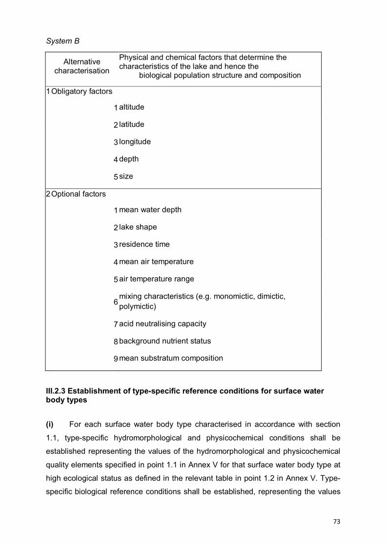
73
System B
Alternative characterisation
Physical and chemical factors that determine the characteristics of the lake and hence the
biological population structure and composition
1 Obligatory factors
1 altitude
2 latitude
3 longitude
4 depth
5 size
2 Optional factors
1 mean water depth
2 lake shape
3 residence time
4 mean air temperature
5 air temperature range
6 mixing characteristics (e.g. monomictic, dimictic, polymictic)
7 acid neutralising capacity
8 background nutrient status
9 mean substratum composition
III.2.3 Establishment of type-specific reference conditions for surface water body types
(i) For each surface water body type characterised in accordance with section
1.1, type-specific hydromorphological and physicochemical conditions shall be
established representing the values of the hydromorphological and physicochemical
quality elements specified in point 1.1 in Annex V for that surface water body type at
high ecological status as defined in the relevant table in point 1.2 in Annex V. Type-
specific biological reference conditions shall be established, representing the values
74
of the biological quality elements specified in point 1.1 in Annex V for that surface
water body type at high ecological status as defined in the relevant table in section
1.2 in Annex V.
(ii) In applying the procedures set out in this section to heavily modified or
artificial surface water bodies references to high ecological status shall be construed
as references to maximum ecological potential as defined in table 1.2.5 of Annex V.
The values for maximum ecological potential for a water body shall be reviewed
every six years.
(iii) Type-specific conditions for the purposes of points (i) and (ii) and type-specific
biological reference conditions may be either spatially based or based on modelling,
or may be derived using a combination of these methods. Where it is not possible to
use these methods, Member States may use expert judgement to establish such
conditions. In defining high ecological status in respect of concentrations of specific
synthetic pollutants, the detection limits are those which can be achieved in
accordance with the available techniques at the time when the type-specific
conditions are to be established.
(iv) For spatially based type-specific biological reference conditions, Member
States shall develop a reference network for each surface water body type. The
network shall contain a sufficient number of sites of high status to provide a sufficient
level of confidence about the values for the reference conditions, given the variability
in the values of the quality elements corresponding to high ecological status for that
surface water body type and the modelling techniques which are to be applied under
paragraph (v).
(v) Type-specific biological reference conditions based on modelling may be
derived using either predictive models or hindcasting methods. The methods shall
use historical, palaeological and other available data and shall provide a sufficient
level of confidence about the values for the reference conditions to ensure that the
conditions so derived are consistent and valid for each surface water body type.
(vi) Where it is not possible to establish reliable type-specific reference conditions
for a quality element in a surface water body type due to high degrees of natural
variability in that element, not just as a result of seasonal variations, then that
element may be excluded from the assessment of ecological status for that surface
75
water type. In such circumstances Member States shall state the reasons for this
exclusion in the river basin management plan.
III.2.4 Identification of Pressures
Member States shall collect and maintain information on the type and
magnitude of the significant anthropogenic pressures to which the surface water
bodies in each river basin district are liable to be subject, in particular the following.
Estimation and identification of significant point source pollution, in particular by
substances listed in Annex VIII, from urban, industrial, agricultural and other
installations and activities, based, inter alia, on information
gathered under:
(i) articles 15 and 17 of Directive 91/271/EEC;
(ii) articles 9 and 15 of Directive 96/61/EC (1) and for the purposes of the
initial river basin management plan:
(iii) article 11 of Directive 76/464/EEC;
estimation and identification of significant diffuse source pollution, in particular
by substances listed in Annex VIII, from urban, industrial, agricultural and other
installations and activities; based, inter alia, on information gathered under:
(i) articles 3, 5 and 6 of Directive 91/676/EEC (4);
(ii) articles 7 and 17 of Directive 91/414/EEC;
(iii) directive 98/8/EC and for the purposes of the first river basin
management plan:
(iv) directives 75/440/EEC, 76/160/EEC, 76/464/EEC, 78/659/EEC and
79/923/EEC.
estimation and identification of significant water abstraction for urban,
industrial, agricultural and other uses, including seasonal variations and total annual
demand, and of loss of water in distribution systems.
estimation and identification of the impact of significant water flow regulation,
including water transfer and diversion, on overall flow characteristics and water
balances.
identification of significant morphological alterations to water bodies
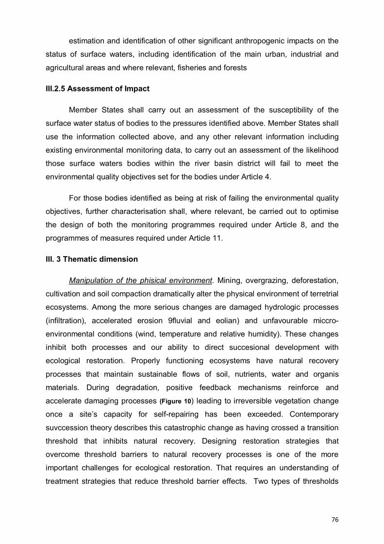
76
estimation and identification of other significant anthropogenic impacts on the
status of surface waters, including identification of the main urban, industrial and
agricultural areas and where relevant, fisheries and forests
III.2.5 Assessment of Impact
Member States shall carry out an assessment of the susceptibility of the
surface water status of bodies to the pressures identified above. Member States shall
use the information collected above, and any other relevant information including
existing environmental monitoring data, to carry out an assessment of the likelihood
those surface waters bodies within the river basin district will fail to meet the
environmental quality objectives set for the bodies under Article 4.
For those bodies identified as being at risk of failing the environmental quality
objectives, further characterisation shall, where relevant, be carried out to optimise
the design of both the monitoring programmes required under Article 8, and the
programmes of measures required under Article 11.
III. 3 Thematic dimension
Manipulation of the phisical environment. Mining, overgrazing, deforestation,
cultivation and soil compaction dramatically alter the physical environment of terretrial
ecosystems. Among the more serious changes are damaged hydrologic processes
(infiltration), accelerated erosion 9fluvial and eolian) and unfavourable miccro-
environmental conditions (wind, temperature and relative humidity). These changes
inhibit both processes and our ability to direct succesional development with
ecological restoration. Properly functioning ecosystems have natural recovery
processes that maintain sustainable flows of soil, nutrients, water and organis
materials. During degradation, positive feedback mechanisms reinforce and
accelerate damaging processes (Figure 10) leading to irreversible vegetation change
once a site’s capacity for self-repairing has been exceeded. Contemporary
suvccession theory describes this catastrophic change as having crossed a transition
threshold that inhibits natural recovery. Designing restoration strategies that
overcome threshold barriers to natural recovery processes is one of the more
important challenges for ecological restoration. That requires an understanding of
treatment strategies that reduce threshold barrier effects. Two types of thresholds
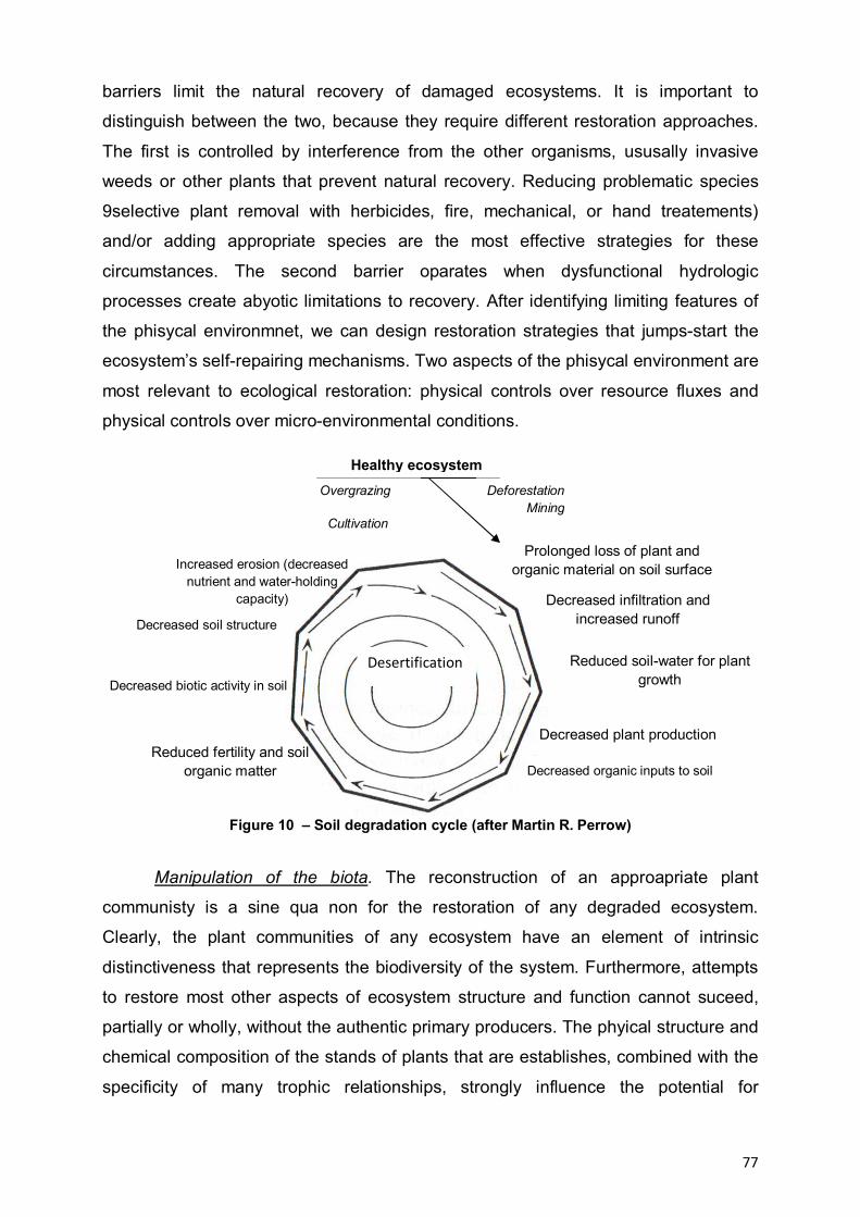
77
barriers limit the natural recovery of damaged ecosystems. It is important to
distinguish between the two, because they require different restoration approaches.
The first is controlled by interference from the other organisms, ususally invasive
weeds or other plants that prevent natural recovery. Reducing problematic species
9selective plant removal with herbicides, fire, mechanical, or hand treatements)
and/or adding appropriate species are the most effective strategies for these
circumstances. The second barrier oparates when dysfunctional hydrologic
processes create abyotic limitations to recovery. After identifying limiting features of
the phisycal environmnet, we can design restoration strategies that jumps-start the
ecosystem’s self-repairing mechanisms. Two aspects of the phisycal environment are
most relevant to ecological restoration: physical controls over resource fluxes and
physical controls over micro-environmental conditions.
Figure 10 – Soil degradation cycle (after Martin R. Perrow)
Manipulation of the biota. The reconstruction of an approapriate plant
communisty is a sine qua non for the restoration of any degraded ecosystem.
Clearly, the plant communities of any ecosystem have an element of intrinsic
distinctiveness that represents the biodiversity of the system. Furthermore, attempts
to restore most other aspects of ecosystem structure and function cannot suceed,
partially or wholly, without the authentic primary producers. The phyical structure and
chemical composition of the stands of plants that are establishes, combined with the
specificity of many trophic relationships, strongly influence the potential for
Prolonged loss of plant and organic material on soil surface
Decreased infiltration and increased runoff
Reduced soil-water for plant growth
Decreased plant production
Decreased organic inputs to soil Reduced fertility and soil
organic matter
Decreased biotic activity in soil
Decreased soil structure
Increased erosion (decreased nutrient and water-holding
capacity)
Healthy ecosystem Overgrazing
Cultivation
Deforestation Mining
Desertification

78
restoration of animal and microbial communities. For the purpose of restoration, land-
form and the proprietes of the soil environment are determinants of plant
communities in two senses.They are integrated attributes of succesional status that
are part of the functional specification of any target ecosystems and hence the
vegetation it can support. The staring point for the restoration of plant communities
must be the restoration of phisycal and soil environments apppropriate to them, or
their succesional precursors. Even where highly satisfactory emulations of a desired
pfysico-chemical environment can be achieved, it will usually be necessary to
introduce populations of desired plant species, to regulate their relative abundance
and to remove or discourage unwanted, invasice species. Such manipulations may
become the mainstay of restoration when the initial disturbance is primarly the result
of the removal of crucial species or of invasion by alien species.
III. 4. Progressive development of tree problems (Logical Framework Analyse) and the SketchMatch method for scanrios and possible renaturation measures
III.4.1 Progressive development of tree problems. In time, favorability and
restrictiveness factors have played an important role in changing by damage or loss
of geographical landscape components in the Danube River (abiotic, biotic, factors
arising from local connection with the natural life, ethnic identity elements or religious
life). Information about existing problems came from a variety of sources including
semi-structured interviews, ethnographic agenda, local media and specialized
literature.
Problem analysis was conducted to create the conceptual model of human
intervention in the geographic landscape of the Danube River, starting from
identifying key factors that have a modifier role and their effect as shown in the
problem tree. Tree problems show the problems in a hierarchical order. First will be
identified causes and effects, then they will be summed and placed in a wider range,
then building the tree as follows:
— what are the causes are at the bottom of the tree;
— what are the effects are at the top of the tree.
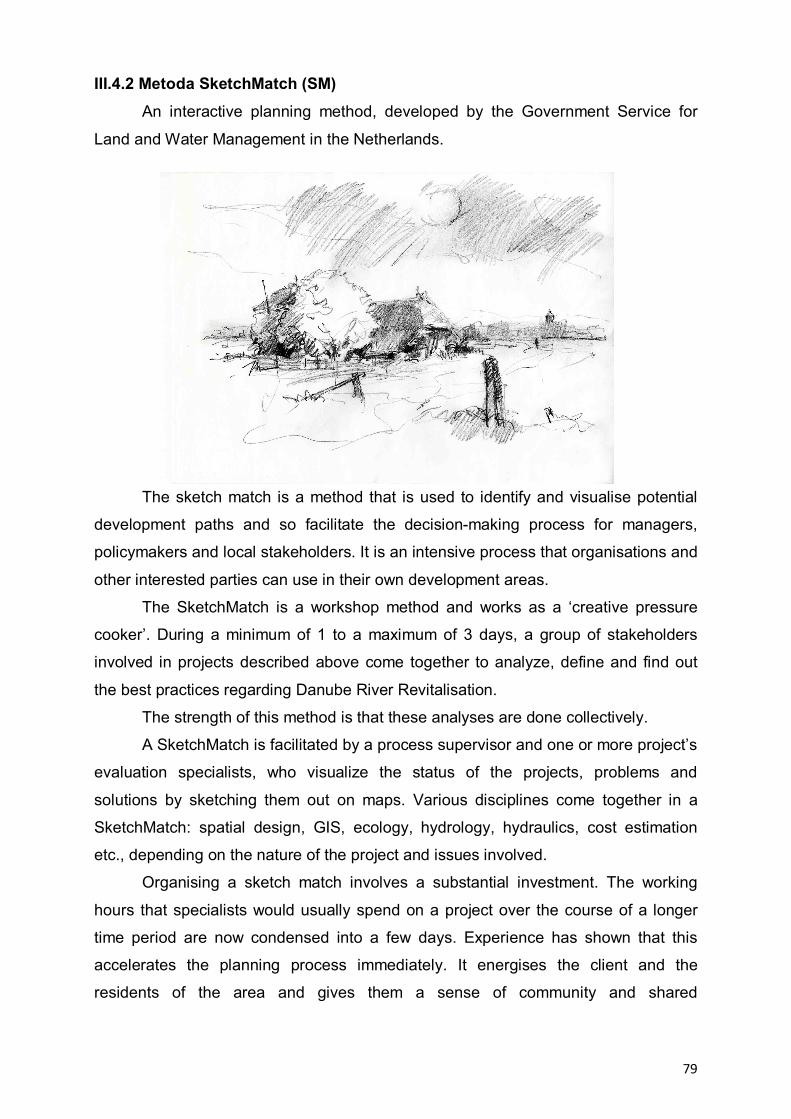
79
III.4.2 Metoda SketchMatch (SM) An interactive planning method, developed by the Government Service for
Land and Water Management in the Netherlands.
The sketch match is a method that is used to identify and visualise potential
development paths and so facilitate the decision-making process for managers,
policymakers and local stakeholders. It is an intensive process that organisations and
other interested parties can use in their own development areas.
The SketchMatch is a workshop method and works as a ‘creative pressure
cooker’. During a minimum of 1 to a maximum of 3 days, a group of stakeholders
involved in projects described above come together to analyze, define and find out
the best practices regarding Danube River Revitalisation.
The strength of this method is that these analyses are done collectively.
A SketchMatch is facilitated by a process supervisor and one or more project’s
evaluation specialists, who visualize the status of the projects, problems and
solutions by sketching them out on maps. Various disciplines come together in a
SketchMatch: spatial design, GIS, ecology, hydrology, hydraulics, cost estimation
etc., depending on the nature of the project and issues involved.
Organising a sketch match involves a substantial investment. The working
hours that specialists would usually spend on a project over the course of a longer
time period are now condensed into a few days. Experience has shown that this
accelerates the planning process immediately. It energises the client and the
residents of the area and gives them a sense of community and shared
80
responsibility. A sketch match can create the momentum a project needs to really
take off, or the impetus required to overcome a deadlock.
However, to have this effect a sketch match must meet a number of conditions
regarding:
a) Definition
The definition must clearly identify the parameters of the problem(s) to be
addressed. In other words: the assignment or problem must be clearly defined.
b) Drafting and visualising
A sketch match is only useful if design and visualisation will genuinely be of
help in identifying potential new development paths and solutions for the issues that
need to be addressed. A sketch match can prove to be useful at any stage of the
planning and implementation process, as long as choices need to be made
concerning spatial planning in a well defined specific area.
c) Results
Drafts must always be produced; calculations are optional. Whenever there
are doubts about the financial and economical feasibility of a project the costs of
different solutions can be calculated immediately. The result of a Sketch Match is a
spatial design, in the form of a manual, guideline, map, book, visual story, model, or
whatever form suits the project best.
Focus groups and semi-structured interviews
There will be organized within each category of subgroups defined by basic
principles of revitalization focus groups. Two researchers must attend every focus
group.
Making a larger number of groups allows drafting of behavioral trends for
categories of subjects interviewed.
a) Not all Focus groups are the same. The interviews will not be exactly the
same in each location. It is very important that the results from different locations are
comparable, and the most important thing is to ensure that, however Focus groups
are arranged.
b) The number of partcipants at Focus group. In terms of numbers, the ideal
number is 5-7 participants. Participants in the discussion will have time to make their
views known about Danube River ecological restoration.
81
c) The Focus groups structures (homogeneous or heterogeneous groups). An
important decision is whether to mix people up in group’s interviews, or have
organized separate groups on the criterion of gender, age. Heterogeneous groups
are useful for hearing differences of opinion, and understanding how conflicts are
negotiated and resolved. However, where there are power differentials between
groups, some people may be afraid to say what they really think.
d) Duration of a interview group. Duration of a interview group shall be
determined according to what should be investigated, and the needs of individuals /
institutions concerned.
e) Instruments used in the Focus groups. In order to make best use analysis,
the investigator shall have different work techniques with applicability to Focus
groups.
Semi-Structured Interviews The purpose of these interviews is to deepen some interesting issues that
arise during the focus groups.
a) Recruiting people. The ideal place for the selection of subjects for individual
interviews is during the group interview in order to analyze certain aspects relevant to
the discussion group.
b) Location is as important as focus groups. It may use the interviewee for a walk
outside to stimulate him to answer questions.
c) Recording the interview. The researcher’s interviews/observations will be recording
on tape or noted in reseracher’s notes book after the free decision of the subjects
and transcribed and processed for analysis. The interviews will be carried from the
interview guide that explains the main criteria and sub-criteria to be addressed
throughout the interview. d) Questions. These will vary from one interviewee to another, depending on the
person being discussed and the problems of group interview. Use your local
knowledge to modify and add to this list.
Begin the conversation by asking your interviewee a few things about
themselves. Anyway you need to know something about the person for the
information gained in the interview to be useful.
A general point is to be over prepared rather than under prepared. It doesn’t
matter if you do not get around to asking all of the questions. Individual interviews
should be preceded by pilot interviews. It is necessary to record the information

82
provided by the interviewee and how the interview went, because the methodology
can be improved further. This is done by keeping a permanent contact with the
coordinator, and that results are comparable between different areas of study.
IV. LESSONS FOR BEST PRACTICES
The facts that we intend to address are often very challenging. Degraded land
areas are rising. Some systems are severely degraded and their reconstruction costs
will highly increase. Moreover, people still use many of these degraded systems. It
will not succeed in fully eradicating the causes of degradation in these
circumstances, but there are enough conclusive results from a variety of case studies
to be optimistic. These results clarify that ecological restoration will be key not only
for conservation but sustainable development also.
Experience accumulated over time in terms of restoration, reconstruction and
environmental rehabilitation, all united under a single term, namely: revitalization. For
the present project will be taken to exemplify several actions and activities that have
been made in the revitalization projects along the River Danube and the Danube
Basin based on questionnaires completed by project partners (Annex 1).
Nb. Name of the project Restoration measures
1 Initial solution to the issue of renaturation of the Morava River in the section Tvrdonice - Devin , Slovacia
- reconnection of side arms has led to
changes in river flow solid,
- the simple reconnection upstream arm
is not sufficiently,
2 Restoration of steep river banks as nesting bird habitats , Slovacia
- main threat to this habitats was
fortification of Danube river banks on the
majority of the Slovak Danube section.
- Removing the embankment,s
determined the Sandmartins to visit this
place almost immediately
3 Activation of the Danube floodplain between
Neuburg and Ingolstadt, Germania
- a permanent flow of water passing the
hydroelectric plant ensuring longitudinal
continuity
- through the detour channel are
controlled the floods
- detour channel provides, in summer,

83
groundwater levels at an optimum level for
the floodplain forest.
4 Sidearm restoration project Schönau
Austria
- Embankment at Danube river banks
was locally lowered to get more inflow
into the side arms
- Check-dams were adjusted with
bridges to increase throughflow (2
times);
5 Sidearm restoration project Orth, Austria Embankment at Danube river banks was locally removed to get more inflow into the side arms (3 places);
- Check-dams were adjusted with
culverts
- Check-dams were removed
6 Sidearm restoration project Haslau, Austria Sidearms have been disconnected from Danube during river regulation;
Sidearms are cut into smaller stretches by check-dams;
7 River bank restoration project Witzelsdorf
(Austria)
- Embankment at Danube river banks was removed or lowered for 1,3 km of banks
- positive effects in terms of flood protection
- mitigation of river bed erosion
8 River bank restoration project Thurnhaufen
(Austria)
- positive effects in terms of flood protection
- mitigation of river bed erosion
- Embankment at Danube river banks was removed or lowered for 3 km of banks;
- groynes were removed or lowered (7 times)
84
IV.1 Multicriterial analyse
Within this activity was developed a matrix of multicriterial indicators grouped
on 4 main assessment criteria as follows: Stakeholder success, Ecological success,
Learning success, River system. Each indicator must receive a value between 1 and
5 corresponding to success level achieved by each restoration project: value 1
represents the most unsuccessful result and value 5 is given to the most successful
result.
Stakeholder success reflects human satisfaction with restoration outcome,
whereas learning success reflects advances in scientific knowledge and
management practices that will benefit future restoration action.
Ecological success
1. Guiding image exists evaluation standards should follow the principles
below:
i. Ecological integrity. Because of strong interference from human activities, it
is not possible to restore urban water ecosystems to the pristine state. Ecological
restoration should be based on achieving the greatest natural state for the specific
region, in reference to its natural state, with the relative ecological integrity as the
target. The health of the ecosystem may not be the original ecosystem, but it must be
a relatively complete ecosystem.
ii. Management categories. In this paper, the evaluation standard is divided
into 3 levels ‘‘healthy, critical state, unhealthy’’.
iii. Objective integrity. Danube River Valley is a complex of ecosystems, and
should meet the flood control objectives, landscape function, and achieve a
harmonious water–human relationship.
iv. Spatial distribution. Within the context of integrated river basin ecosystem
theory, the evaluation of the ecological restoration sites should consider the
characteristics of the different spatial components and the differences of
environmental problems in each area, including differences between upstream and
downstream locations and different ecosystem service function.
2. Ecological improvement. Ecologically successful restoration will induce
measurable changes in physicochemical and biological components of the target
river or stream that move towards the agreed upon guiding image.
3. Self sustaining

85
The ecosystem is self-sustaining. It has the potential to persist indefinitely
under existing environmental conditions. Aspects of its biodiversity, structure and
functioning will change as part of normal ecosystem development, and may fluctuate
in response to normal periodic stress and occasional disturbance events of greater
consequence. As in any intact ecosystem, the species composition and other
attributes of a restored ecosystem may evolve as environmental conditions change.
Ecologically successful river restoration creates hydrological, geomorphologic and
ecological conditions that allow the restored river to be a resilient self-sustainable
system, one that has the capacity for recovery from rapid change and stress (Holling
1973; Walker et al . 2002, cited by Palmer, 2005). Natural river ecosystems are both
self-sustaining and dynamic, with large variability resulting from natural disturbances.
4. No lasting harm is done
In the last century, Aldo Leopold (1948) , cited by Palmer, 2005, stated that
the first ‘rule’ of restoration should be to do no harm. Restoration is an intervention
that causes impacts to the system, which may be extreme (e.g. channel
reconfigurations). Even in such situations, an ecologically successful restoration
minimizes the long-term impacts to the river. For example, a channel modification
project should minimize loss of native vegetation during in river reconstruction
activity, and should avoid the fish-spawning season for construction work. Indeed,
removal of any native riparian vegetation should be avoided unless absolutely
necessary. Additionally, restoration should be planned so that it does not degrade
other restoration activities being carried out in the vicinity (e.g. by leading to
permanent increases in the downstream transport of sediments that are outside the
historical range of sediment flux).
5. Ecological assessment is completed- pre and post project assessment is
conducted and the information made available
Ecological success in a restoration project cannot be declared in the absence
of clear project objectives from the start and subsequent evaluation of their
achievement (Dahm et al . 1995). Both positive and negative outcomes of projects
must be shared regionally, nationally and internationally (Nienhuis & Gulati 2002,
cited by Palmer, 2005).
86
Learning success
The circumstances that we seek to address are often very challenging. The
areas of degraded land now present in various parts of the world are large. Some
systems are severely degraded and will be costly to repair. Further, people are still
using many of these degraded systems and many of these people are poor. We may
not succeed in fully eradicating the causes of degradation in these circumstances but
there is sufficient evidence from a variety of case studies for us to be optimistic. This
evidence makes it clear that ecological restoration will be a key element not only of
conservation but also for sustainable development worldwide.
River system it is about the river connectivity (lateral, longitudinal &
temporal).
Further more, the matrix developed was applied on each identified project in
previous phazes in order to stress out its eficacity (Table 4, 5).
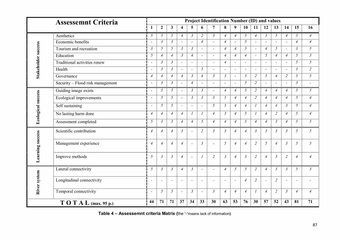
87
Project Identification Number (ID) and values Assessemnt Criteria 1 2 3 4 5 6 7 8 9 10 11 12 13 14 15 16
Aesthetics 5 5 5 4 3 2 3 4 4 5 4 3 5 4 5 4 Economic benefits - 3 3 - - 4 - 4 - 5 - - - - 4 4
Tourism and recreation 3 5 5 3 3 - - 4 4 5 - 4 5 - 3 5
Education 5 4 4 3 4 - - 4 4 4 - 5 4 4 5 3
Traditional activities renew - 3 3 - - - - 4 - - - - - - 5 5
Health - 3 3 - - 5 - - - - - - - - 3 2
Governance 4 4 4 4 3 4 3 3 - 5 2 5 4 2 5 5 Stak
ehol
der
succ
ess
Security – Flood risk management - 3 3 - 4 - - - - 5 2 - - - 3 -
Guiding image exists - 5 5 - 3 3 - 4 4 5 2 4 4 4 5 5
Ecological improvements - 5 5 - 3 3 3 5 4 4 2 4 4 4 5 4
Self sustaining - 5 5 - - - 5 5 4 4 1 4 4 3 5 4
No lasting harm done 4 4 4 4 1 1 4 3 4 5 1 4 2 4 5 4
Eco
logi
cal s
ucce
ss
Assessment completed 5 3 3 4 4 5 4 4 4 5 4 4 3 4 5 5
Scientific contribution 4 4 4 3 - 2 3 3 4 4 3 3 3 3 5 5
Management experience 4 4 4 4 - 3 - 5 4 4 2 5 4 3 5 5
Lea
rnin
g su
cces
s
Improve methods 5 3 3 4 - 1 2 3 4 3 2 4 3 2 4 4
Lateral connectivity 5 3 3 4 3 - - 4 5 5 2 4 3 3 5 3
Longitudinal connectivity - - - - - - - - - 4 2 - 2 - - -
Riv
er sy
stem
Temporal connectivity - 5 5 - 3 - 3 4 4 4 1 4 2 3 4 4
T O T A L (max. 95 p.) 44 71 71 37 34 33 30 63 53 76 30 57 52 43 81 71
Table 4 – Assessemnt criteria Matrix (the “-“means lack of information)
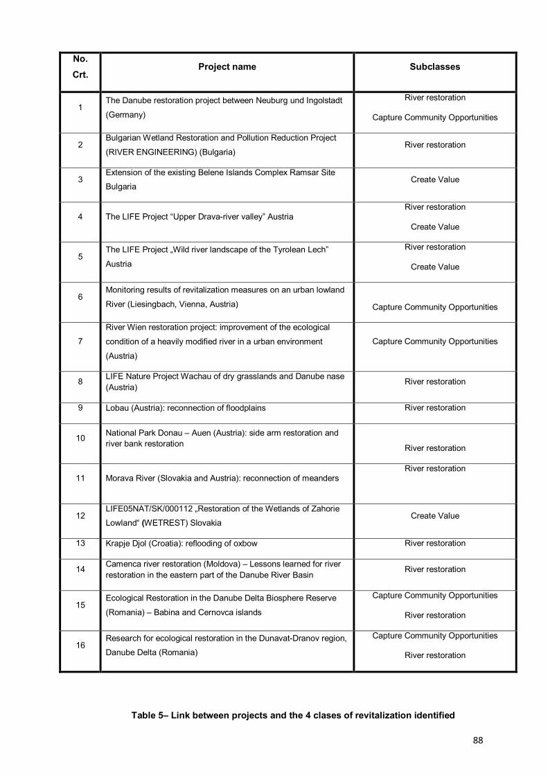
88
No. Crt.
Project name Subclasses
1 The Danube restoration project between Neuburg und Ingolstadt
(Germany)
River restoration
Capture Community Opportunities
2 Bulgarian Wetland Restoration and Pollution Reduction Project
(RIVER ENGINEERING) (Bulgaria) River restoration
3 Extension of the existing Belene Islands Complex Ramsar Site
Bulgaria Create Value
4 The LIFE Project “Upper Drava-river valley” Austria River restoration
Create Value
5 The LIFE Project „Wild river landscape of the Tyrolean Lech”
Austria
River restoration
Create Value
6 Monitoring results of revitalization measures on an urban lowland
River (Liesingbach, Vienna, Austria)
Capture Community Opportunities
7
River Wien restoration project: improvement of the ecological
condition of a heavily modified river in a urban environment
(Austria)
Capture Community Opportunities
8 LIFE Nature Project Wachau of dry grasslands and Danube nase (Austria)
River restoration
9 Lobau (Austria): reconnection of floodplains River restoration
10 National Park Donau – Auen (Austria): side arm restoration and river bank restoration
River restoration
11 Morava River (Slovakia and Austria): reconnection of meanders River restoration
12 LIFE05NAT/SK/000112 „Restoration of the Wetlands of Zahorie
Lowland“ (WETREST) Slovakia Create Value
13 Krapje Djol (Croatia): reflooding of oxbow River restoration
14 Camenca river restoration (Moldova) – Lessons learned for river restoration in the eastern part of the Danube River Basin
River restoration
15 Ecological Restoration in the Danube Delta Biosphere Reserve
(Romania) – Babina and Cernovca islands
Capture Community Opportunities
River restoration
16 Research for ecological restoration in the Dunavat-Dranov region,
Danube Delta (Romania)
Capture Community Opportunities
River restoration
Table 5– Link between projects and the 4 clases of revitalization identified
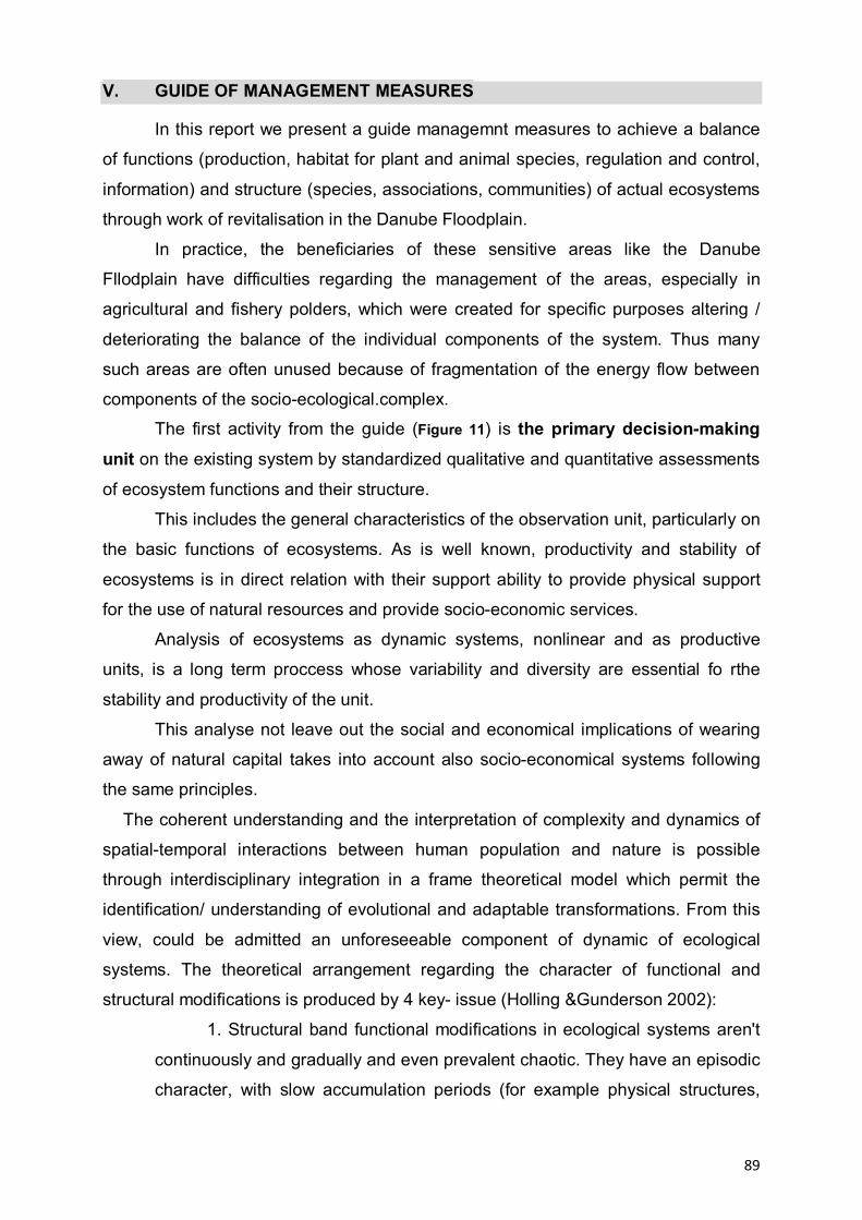
89
V. GUIDE OF MANAGEMENT MEASURES
In this report we present a guide managemnt measures to achieve a balance
of functions (production, habitat for plant and animal species, regulation and control,
information) and structure (species, associations, communities) of actual ecosystems
through work of revitalisation in the Danube Floodplain.
In practice, the beneficiaries of these sensitive areas like the Danube
Fllodplain have difficulties regarding the management of the areas, especially in
agricultural and fishery polders, which were created for specific purposes altering /
deteriorating the balance of the individual components of the system. Thus many
such areas are often unused because of fragmentation of the energy flow between
components of the socio-ecological.complex.
The first activity from the guide (Figure 11) is the primary decision-making unit on the existing system by standardized qualitative and quantitative assessments
of ecosystem functions and their structure.
This includes the general characteristics of the observation unit, particularly on
the basic functions of ecosystems. As is well known, productivity and stability of
ecosystems is in direct relation with their support ability to provide physical support
for the use of natural resources and provide socio-economic services.
Analysis of ecosystems as dynamic systems, nonlinear and as productive
units, is a long term proccess whose variability and diversity are essential fo rthe
stability and productivity of the unit.
This analyse not leave out the social and economical implications of wearing
away of natural capital takes into account also socio-economical systems following
the same principles.
The coherent understanding and the interpretation of complexity and dynamics of
spatial-temporal interactions between human population and nature is possible
through interdisciplinary integration in a frame theoretical model which permit the
identification/ understanding of evolutional and adaptable transformations. From this
view, could be admitted an unforeseeable component of dynamic of ecological
systems. The theoretical arrangement regarding the character of functional and
structural modifications is produced by 4 key- issue (Holling &Gunderson 2002):
1. Structural band functional modifications in ecological systems aren't
continuously and gradually and even prevalent chaotic. They have an episodic
character, with slow accumulation periods (for example physical structures,
90
concentrate energy) conked out of sudden changes (release and
reorganisation).
The productivity and stability of ecosystems established of support capacity or
possibility to ensure physique support, natural resources and services for
socio/economical systems.
2. Spatial organisation of landscape is grouped and discontinuous are
differing from connection and breaking up/apportionment point of view. It can
differentiate functional categories of spatial scale, architecture (size, shape,
connectivity) of components which are resulted throughout grouping and
organisation of biotic an abiotic elements.
3. Ecological systems have an unlinear dynamic, among a complex of steady
states circumcised of a stability domain in his turn dynamic. The unlinear
character is given by processes as: reproduction, competition, energy flux,
biogeochemical circuits of nutrients.
The intern or extern instability forces chime in assuring, creating and
maintenance of diversity stability (durability) and opportunities of answer, and
stabilizer forces have an importance to maintenance of fundamental ecological
process: energy flux, recycling of nutrients, respectively
to ensuring the level of productivity.
4. The policies and management systems which using restricts and immuable
rules to ensuring of constant productions to ecological systems or economical
systems, besides to take into account time and space scale, having as effect
diminish of stability domain or resilience.
This block is thought to supplement through evaluation of level and quality of
ecosystems functions: a) productive, b) regulating, c) habitats for species of plants
and animals, d) informational.
The purpose of this analyse is to reflect the dynamic of variables of state
(functional and structural) and of control factors, through:
e) determination of indicators regarding the structure, the composition and
operating of components of natural capital and socio- economical systems as well as
indicators set hereby are appreciated the reports between CN and SEE or co-
developing reports;
f) evaluation of impacts and ecological risk;
91
g) identification of tendency of structural and functional modification;
h) diagnosis of modification causes.
This block is meant to start the process of developing the functional and
stochastic models and scenarios based on existing information through an
information cascade. In fact, it is an integration system for both diagnosis and for
decision-making.
It is important to point out that the final evaluation from the final decision and implementation block should take into account the financial aspect, the economic
analysis type, and cost-benefit.
This assessment framework is very useful in areas of comparative assessment
of natural and economic use. A general assessment of Services flow provided by the
system must take into account its dynamics.
The revitalised system will be monitored both in the implementation but
particularly after the implementation phase. In block implementation were mentioned
works for correction, when the evolution of the system does not correspond with the
foressen one.
The final phase of such a project should lead to inclusion in the list of
protected areas and realise a management plan for it.

92
Figuea 11 – The structure of measurement guide
93
VI RELATION BETWEEN THE DANUBE PARKS NETWORK AND REVITALISATION PARKS
The overall objectives of the Danube Parks network of protected areas must
take into account the following aspects:
- maintaining the biodiversity of Europe, for example ensuring the ecological
coherence and connectivity of the Natura 2000 network (Article 10 of the
Habitats Directive);
- protection and restoration of valuable natural ecosystems to a more
general level that they can continue to provide valuable services to
humanity.
In this context, the subject of revitalization areas can contribute and even
support the Danube Parks network , for example, to help expand the size of
protected areas, increase the areas of food, breeding or rest for the species and to to
assist in the migration / dispersion process.
The Danube Parks network can be developed through:
- Improve connectivity between existing natural areas to counter
fragmentation and enhance their ecological coherence,
- Greater permeability of the landscape to support species dispersal,
migration and movement, for example using land in a favorable for fauna and
flora or introducing agricultural or forestry environmental schemes that support
extensive agricultural practices
- Identification of multifunctional areas. In such areas, compatible land
use that supports healthy ecosystems is favored against destructive practices.
In practice, one of the most effective ways of achieving these principles is
adopting a more integrated approach to land management at three levels: local,
regional, watershed. This in turn is best achieved through a Spatial Planning, which
allows investigation of spatial interactions between different components.
Spatial planning is also a way to bring together different economical sectors
for them to decide on local / regional / basin priorities of land use in a transparent,
integrated and cooperative way. Spatial planning can guide the development of
infrastructure outside sensitive sites, thus reducing the risk of further fragmentation of
habitats

94
It also can find ways to reconnect the natural remaining areas, or even
encouraging habitat restoration projects in areas strategically important, or
incorporating elements of continuity / connectivity in the new eco-development
schemes.
VI.1 Spatial planning approach in river basin
It is considered that a unified approach to river basin has its advantages over
other approaches, where revitalization is addressed in an integrated manner,
including coordination and coherence between mitigation and adaptation and
policies.
There are several reasons why spatial planning should be in the river basin. Among
them:
- water management can contribute to improving processes (eg, hydropower)
and the processes of adaptation (eg water retention);
- a holistic approach stimulates cross-disciplinary research and develop
improved policies;
- Currently there are no dichotomy in mitigation and adaptation processes:
planning practices will determine, whether relevant, the integrated responses
between mitigation and adaptation
- The river basin approach allows to assess possible synergies, compromises
and adaptation measures to improve the water catchment area in an integrated
manner
- Most indicators of impact measures could be monitored at the catchment
scale, which would allow more effective assessment
Improvement and adaptation strategies can be more easily integrated spatial
planning process.
Of course, some disclaimers may be made. First of all, changing the traditional
way is not something that can be modified easily and takes time.
Moreover, there remains a mismatch between the basin approach and other
socio-economic processes that has to be reconciled. In order to fully use the
response capabilities for both mitigation and adaptation measures should be included
socio-economic processes (such as technological development, development of
knowledge and, perhaps most importantly, economic development).

95
VI.2 The concept of Integrated Regional Ecological Network in the National Ecological Network and European international initiatives
Protection and conservation of biodiversity is central to nature conservation
strategies worldwide. It became apparent that one of the key elements to ensure a
healthy environment for future generations is to maintain a high level of ecological
biodiversity. Even in protected areas, species disappear. Experts realize that our
knowledge on the dynamics involved in the protection of nature, gives us new
opportunities to improve how we organize nature protection.
One of the key events in establishing new trends has been the United Nations
Rio Convention on Biological Diversity (1994 Rio de Janeiro). Over 160 countries
have signed the Convention, which aims to preserve biodiversity, encourage
sustainable use and equitable sharing of benefits from the use of genetic resources.
Convention is built on a number of previous regulations and conventions, as a
Ramsar Convention (1971) on Wetlands of International Importance, CITES (1973)
Convention on International Trade in Endangered Species of Wild Flora and Fauna,
and Bern (1979) Convention on Conservation of Natural Habitats and Wild from
Europe.
Rio Convention (1992) gave a new impetus for international activities. It
coincided with the Habitats Directive, Council Directive 92/43/EEC on the
conservation of natural habitats and wild flora and fauna. Habitats Directive is the
most important EU instrument for nature protection, and anticipates the preparation
and establishment of sites of Community Importance for inclusion in Natura 2000, a
network of representative habitats.
Due to EU membership, countries should harmonize their legislation, which in
the environment sector is particularly affected by the Habitats Directive. Was
mentioned the European Natura 2000 network, which have been associated with
other countries. Should also mention that EMERALD Network tends to be implement
Berne Convention (1979). Bern Convention Habitats Directive (1992) follows the
same objectives, which hich tend to conserve wild flora and fauna, natural habitats.
The EMERALD concerns Europe and parts of Africa. Both initiatives, however, are
closely coordinated and not overlapping.

96
In 1995 the Ministerial Conference "Environment for Europe"in Sofia has
identified the requirements for a "Strategy for Pan-European Biodiversity and
Landscape Diversity", including several action plans. The first plan of action is to
establish a pan-European ecological network. Based on sharing information and
coordinating initiative, the strategy addresses to all the existing measures and
identify any additional actions required.
The concept of ecological networks
Nature conservation was based on protecting sites. were identified Areas with
a particular ecological interest and human intervention was limited. Protected areas
that resulted were often isolated in a desert, surrounded by vast hostile territories
(intensive agriculture, cone constructed, and monocultures). Worse, protected areas
were often designed (selected) not by their ecological value, but because of their
reduced ecological value. Habitats that have become isolated can not maintain the
original species richness unless they are connected to similar habitats elsewhere.
Clearly, many factors influence the resilience of species in protected areas.
The effects of isolation will be offset by the size of the protected area, the original
size and species diversity. Potential accidental migrations will depend on the
distance between areas inhabited by certain species, and may have beneficial effects
(maintaining biodiversity) or harmful (invasive species competition). Ecological
networks tend to increase the possibility of migration through the corridors.
Spatial coherence Ecological principles have now evolved to include landscapes. "Island
Biogeography" and "Metapopulation" theories introduce spatial "coherence" in nature
conservation strategies and planning organization. The idea that supports ecological
networks is that populations can migrate from an inhabited area (whether protected
or not) to another. The result would be an increase of energy flow, migration and
genetic adaptation to local conditions. When resources are scarce in an area,
populations can migrate to avoid failing. Furthermore, migration can "complete"
certain gaps in abandoned sites.
As it may be observed, the concept of ecological networks is based on the
introduction of coherent spatial structures. The Core Areas, corridors, buffer areas
and areas of ecological restoration are essential to ecological networks. Designing a
complete network will include each of these support elements. As the classical
97
principles of nature conservation, using different levels of protection is associated
with ecological networks. To allow multiple use of the network - avoiding
unnecessary or excessive restrictions - the level of protection will be adapted to local
needs. This will vary from strict protection (restrictions for recreational use, for
example.) to partial limitation for economic uses.
The core areas are areas that contain unique landscapes and habitats, with
special ecological value. Preserving these characteristics contributes to biodiversity
protection. The level of protection of this areas should be most intense, because they
are home to those items that have the greatest need of protection.
The corridors are essentially characterized by migration, dispersal, genetic
exchange and energy flow. They make the connection between the various core
areas allowing these exchanges, and decreasing isolation and "island" situations.
Buffer areas surround a specific interest areas (usually areas with full
protection) in order to reduce or buffer the negative impact from the outside.
Limitations on certain economic or recreational activities in buffer areas prevent
affecting the core areas.
Ecologival restoration areas may be important for the global design of the
ntwork or may present a high environmental and ecological potential. We have
shown above that only the least favorable sites, dry and nutrient-poor tend to be left
for the implementation of conservation projects while the most interesting areas from
ecological point of view are generally used for agriculture. Reconstruction supports
the return to nature of high biodiversity areas with significant landscape value.
Design a network may seem simple in theory, but it is a very complex task
because often need to combine conflicting interests. Different species do not always
have the same needs, and may be required for priority setting and a combination of
goals.
Selection and identification of ecological network components is a complex
process based on a comprehensive view of natural and human activities. In this
process must be collected and analyzed a large amount of data. Tools as maps of
forestry, land, biota, water quality, biodiversity monitoring data must be used to
provide the basis for a coherent network. EU CORINE Biodiversity and CORINE
Land Cover initiatives are very valuable tools for such purposes.

98
Stages of an ecological network The first step to achieve ecological networks would be to define areas of a certain
importance. This activity depends on the criteria and careful analysis of the data. At
this stage, one must try to balance the various modes of land use, based on
priorities.
Policymakers should first be able to identify landscape elements that define a certain
corridor, and then to understand how individuals and local populations respond to it.
The effectiveness of a corridor regarding the mobility of species that occur can not be
easily defined when it includes a wide variety of organisms (large and small
mammals, insects, small birds). The presence of individuals of other species such as
predators that could influence the migration and survival of target species is another
example of the complications that arise when it comes to networking.
However, once all information is gathered, priorities and criteria defined are defined
and analysed can expect to design a network, at least on paper. The next step is a
very simple procedure and requires making sure that all items are enjoying a level of
protection required. This includes defining the exact extension of the area, ensuring
that they are all available for protection (eg. some may be privately owned) and to
obtain all necessary local support.
VI.3 National and european ecological network
European Ecological Network (EECONET) started to develop at the initiative
of the Netherlands- Institute for European Environmental Policy, which developed the
concept of ecological network in 1991. This concept has expressed the idea of an
integrative and dynamic protection of species and organisms related with their
environment and rely on identifying the most significant ecosystems as 'fully
protected areas'. It also includes protection of 'green corridors', promoting the
migration and dispersal of living organisms and, naturale'semnificative development
areas particularly in terms of functional ecological network and its individual
subsystems (Bennett, 1991).
The idea of European ecological network (EECONET) recommends to be
included and unprotected areas that have not so far been protected by law significant
for EECONET dynamic and also requires the protection of ecological corridors within
the meaning of the corridors of European importance, national or regional .
99
EECONET emphasizes the importance of interconnection fragmented and
diffuse biotopes, with ecosystems in the landscape with econoomic use, significantly
changed or disturbed. EECONET can also play an important role in reducing the
consequences of global warming; many species are endangered, if they do not have
new habitats and routes to areas with suitable climatic conditions .
Creating European Ecological Network is now focused on two levels: a. EECONET –European ecological network is a network of fully protected areas
and other important elements in terms of biodiversity and ecosystems, at
European level,
b. NECONET –National Ecological Network is a network of fully protected areas and
other major national importance, in some cases at the multinational level.
At the international conference in Maastricht "Towards a European Ecological
Network by protecting the natural heritage" in 1993, was defined EECONET as an
effective pan-European framework for a more effective nature conservation in
Europe. Components EECONET concept became a full European biodiversity
conservation strategies. Integrated in NECONET concept, the regional ecological
networks will develop on specific physical and geographical units, consisting of fully
protected areas, ecological corridors and areas of ecological restoration in
anthropogenically disturbed areas.
There have been declared the main strategic goals of biodiversity conservation at a
conference in Maastricht, and formulated the conclusions, as follows (Bennett, 1994):
a. protect and restore all key ecosystems and all important species of European
importance
b. management of high nature value areas (including biodiversity) by means of
professional managers and extensive agriculture, forestry and fisheries
sustainability.
c. restoring natural processes with minimal interference with human activities across
Europe;
d. increase quality of the farm areas as a whole, including coastal areas for
conservation of all ecosystem’s conditions.
e. accept the principle of sustainability as the main principle for decision and action
plans.

100
f. strengthen a broad public support for nature protection and enhance biological
and landscape diversity in farm areas;
g. all European nations to contribute to a sustainable living.
EECONET support existing international systems of territorial conservation
and facilitate the construction of a coherent European ecological network (including
full protection areas) representing all types of habitats. This network will support
effective ways to conserve species and fragile ecosystems, transboundary
conservation areas with high natural value, conservation of migratory routes
identified. The result must also be shifting the emphasis on nature conservation
policies of the species to habitat, from sites to ecosystems, from regional measures
to national and even international measures (Bennett, 1991).
At national and internationallevel the ecological network has been proposed
so far in the Netherlands and Spain. Similar concepts have been applied in the
Czech Republic and Slovakia, however, still not including pan-European criteria more
widely accepted.
EECONET basic concept – dutch experience
In 1990 the Dutch government and parliament accepted the National Strategy for the
conservation of nature - the nature Plan of decision-making - NPP, in which
EECONET was an essential component. Netherlands ECONET idea appeared in
1987, and its preparation took four (4) years. Choosing the key species was based
on:
1. their international significance (including IUCN list or western Palearctic
species of which at least ¼ nest in the Netherlands), the negative trend - a significant
withdrawal of the species at national scale (50% decline in the number of World War
II, 25% decline in bird species)
2. rarity – national level (their distribution less than ¼ of the area, or species of
birds, more than 12,500 breeding pairs).
On the list of tracked species were included the following taxonomic groups: plants,
mammals, birds, reptiles, amphibians, fish, butterflies, dragonflies and other and
others, together representing about 700 species.
101
Criteria for selection of core areas (Bennett, 1991): a. fully protected areas are typical habitats, characterizing each biogeographical
region
b. they are characterized by natural ecological processes (protection of areas with
substantial representation of the original ecosystems)
c. they are characterized by a high degree of biodiversity (conservation areas with a
high genetic diversity, high diversitu of species and ecosystems)
d. are characterized by an abundance of endemic species and critically endangered
(conservation of endemic species, endangered, rare,
e. are particularly significant for migration or dispersal of species (both nationally
and at European level)
In addition, the minimum size criterion was applied to the full protection areas
of national and international fixed at 500 hectares (1,000 ha for forest). However, for
unique or significant areas in particular, have been included even smaller areas.
There have also been taken into account other functions of the protected areas as
support function for agriculture, forestry, fishery, and their synergistic impact on the
value area (Bennett 1991, Lammens 1994).
Selection criteria for ecological corridors (Opschor, 1993):
a. size of connected coreareas (to be connected to each other);
b. distance from other equivalent habitat types;
c. nature corridor, size and presence of barriers;
d. corridor anthropogenic pressure (urbanization, agriculture);
e. the degree of degradation of the corridor
f. . where necessary, taking into account the possible consequences of global
warming.
Ecological corridors have been proposed to consider in particular the necessary data
available and also of river Rhine and Mase that were chosen as EECONET elements
(Lammens, 1994).
Criteria for selection of areas of natural development (revitalisation areas): a. ecological significance, the necesity to build a corridor;
b. potential vegetation structure in a new corridor;
c. the existence of reserve corridors;
d. pressure development on newly created corridor (Van Dijk, 1993)
102
Areas with greatest potential of restoration were designated wetlands, forests,
desertified agricultural areas and for renaturation nutrient poor grassland, swamps
and wooded areas. ECONET also stimulated revegetation plans for endangered
species habitat , (Van Genne, 1994).
Basic priciples of ECONET adopted at Stefanova (Slovacia) There are different views of experts regarding the design of NECONET and
ECONET. in September 1994 took place in the village of Stefanova in Slovakia, a
small seminar in which IUCN adopted the following additional criteria for selecting
basic elements ECONET:
A. For selecting ecological network components, is important that:
1. biogeographical units work to be done at the sub provincial level;
2. networks must be functional entities for long-term survival of natural communities,
including species dispersal and migration;
3. networks should be as consistent with existing protected areas;
4. network designing can be done at different scale stil are recommanded scale
1:500.000 and 1:1.000.000 for national and pan-European
B. the selected core area must have the following features: 1. to be representative of a certain sub region biogeographic, and / or unique
importance in terms of pan-European;
2. to be composed of natural ecosystems and / or semi and / or restored natural
ecosystems ecological reconstructed;
3. have high importance for biodiversity and / or to accommodate endangered
species or threatened;
4. to have a certain minimum size (500H recommended at European level) and its
spatial position to work for species that are endangered and those native
5. to function as a source for native species distribution over a larger surrounding
area.
C. Selection of ecological corridors should be made taking into account the following features:
1. to facilitate the dispersal of species in suboptimal habitats from surrounding full
protection areas;
2. a pathway (by linking protected areas with full natural development areas) for
migration and dispersal of species on a European scale;
3. be a refuge for species as an extension of full protection areas.

103
D. Selection of the natural areas shiuld be done taking into account the follolwing features:
1. ites will be selected for proper management of nature;
2. areas for restoring natural values necessary for network sustainable;
3. areas with prospects and ability to expand protected areas in full size, for
example. using points with a great diversity in abiotic conditions, which can be
preserved long term '
4. To be located in the way of important migration routes of indigenous species at
the European level.
104
REFERENCES:
1. Benke, A. C. (2001), Importance of flood regime to invertebrate habitat in an
unregulated river–floodplain ecosystem. Journal of the North American
Benthological Society. 20:225-240.
2. Binder W., (2008), River restoration: an European overview on rivers in urban
areas. In ECRR Conference on River Restoration, vol. 4th, Editor Gumiero B.,
Rinaldi M., Fokkens B., pg. 95-100, Italy, Venice S. Servolo Island.
3. Drost H.J., Bos D., Tudor M., (2002), Research for ecological restoration in the
Dunavat-Dranov region, Danube Delta, Editor Altenburg & Wymenga
ecological consultants / RIZA Lelystad
4. Kondolf, G. M., A. J. Boulton, S. O'Daniel, G. C. Poole, F. J. Rahel, E. H.
Stanley, E. Wohl, A. Bång, J. Carlstrom, C. Cristoni, H. Huber, S. Koljonen, P.
Louhi, and K. Nakamura 2006. Process-based ecological river restoration:
visualizing three-dimensional connectivity and dynamic vectors to recover lost
linkages. Ecology and Society 11(2): 5.
5. P.H. Nienhuis and R.D. Gulati (2002), Ecological Restoration of Aquatic and
Semi-Aquatic Ecosystems in the Netherlands (NW Europe). Hydrobiologia
478: 1–6, DOI: 10.1023/A:1021077526749
6. M.A. Palmer et. all (2005), Standards for ecologically successful river
restoration, Journal of Applied Ecology, Volume 42, Issue 2, pages 208–217
7. Payet R. A, (2007) - Impact of Climate Change on Tourism in Seychelles and
Comoros, Department of Environment, Victoria, Mahe, Seychelles, The International
START Secretariat. SUA
8. Perrow R.M, Davy A.J., (2002), Handbook of Ecological Restoration, vol 1-2,
Cambridge University Press
9. Thom R.M., Diefenderderfer H. L., (2004), A Framework for Risk Analysis in
Ecological Restoration Projects, Prepared for the U.S. Department of Energy
under Contract DE-AC06-76RL01830

105
10. Thom, R.M., Diefenderfer H.L. și Hofseth K.D., (2009) - A Framework for Risk
Analysis in Ecological Restoration Projects, National Technical Information Service,
Springfield, SUA
11. *** 1997 - Ecological restoration in the Danube Delta Biosphere Reserve /
Romania, ICPDD-Tulcea and WWF-Auen-Institute,
12. *** (1999), Evaluation of wetlands and floodplain areas in Danube River
Basin, WWF Danube- Carpathian-Programme and WWF-Auen-Institut (WWF
GERMANY)
13. *** 2008 - Evolution of Babina polder after restoration works, WWF-Germany
and DDNI-Tulcea, Kraft-Druck Ettlingen
14. * * * (2006-2008), Analiza dinamicii peisajului geografic din Delta Dunării pe baza indicilor sintetici (D.P.S.I.R.) ai Agenţiei Europene de Mediu (E.E.A.), Arhiva Bibliotecii I.N.C.D.D.D. Tulcea.
Internet sources:
www.broz.sk
www.biomura.si
http://bulgarsko.eu/ovm.php?l=en&pageNum_Ovm_All=0&totalRows_Ovm_All=113&id=17
http://siteresources.worldbank.org/BULGARIAEXTN/Resources/WetlandsBroshure6.pdf
http://www.icpdr.org/icpdr-pages/dw0803_p_06.htm
http://forecaster.ontwikkel.gisinternet.nl/index.php?title=Description
http://www.espon.eu/main/Menu_Programme/ www.life-wachau.at
www.lariverrmp.org
http://forecaster.deltares.nl/index.php?title=Babina
http://forecaster.deltares.nl/index.php?title=Cernovca