CERCETRI ARHEOLOGICE · I. RAPOARTE ARHEOLOGICE Eugen Teodor, Anca P unescu, Ernest...
37
MUZEUL NAŢIONAL DE ISTORIE A ROMÂNIEI CERCETĂRI ARHEOLOGICE XVIII–XIX
Transcript of CERCETRI ARHEOLOGICE · I. RAPOARTE ARHEOLOGICE Eugen Teodor, Anca P unescu, Ernest...
MUZEUL NAŢIONAL DE ISTORIE A ROMÂNIEI
CERCETĂRI
ARHEOLOGICE
XVIII–XIX

ISSN 0255-6812
CERCETĂRI
ARHEOLOGICE
XVIII–XIX
BUCUREŞTI
2011–2012
Redactor şef: Dr. Dragomir Popovici
Tehnoredactare, prelucrare imagine: Adela Bâltâc, Cristina Joiţa
Coperta: Dan Mărgărit
Colectivul de redacţie:
Dr. George Trohani
Dr. Liviu Petculescu
Dr. Anca Păunescu
Prof. Dr. Lietta De Salvo
Secretar de redacţie:
Dr. Adela Bâltâc
Coperta: Brățări dacice (MNIR). Coperta I: nr. 11; Coperta IV: nr. 6.
Această publicaţie poate fi consultată şi on-line la adresa www.mnir.ro
Volum editat de Muzeul Naţional de Istorie a României
Calea Victoriei nr. 12, Bucureşti, 003246, România
Printed in Romania
Editura Cetatea de Scaun, www.cetateadescaun.ro, email [email protected]
ISSN 0255-6812
I. RAPOARTE ARHEOLOGICE
Eugen Teodor, Anca Păunescu, Ernest Oberländer-Târnoveanu, Mihai
Tomescu, Săpături de salvare la hanul Constantin Vodă (1996) 9
Dejan Radičević, Vojislav Đorđević, Jelena Đorđević, Mediаeval Settlement and
Necropolis at Najeva Ciglana Site in Pančevo (Southwestern Banat): Excavations in
2003 and 2004
79
II. STUDII
Robert Kuhn, Prunk-Schminkpaletten aus der Formativen Phase Altägyptens. Neue
Überlegungen zur Einteilung und Deutung Einer Fundkategorie 125
Silviu Oţa, Un nou cercel descoperit la Oraşul de Floci (comuna Giurgeni, judeţul
Ialomiţa) 149
George Trohani, Câteva bunuri arheologice de valoare excepţională pentru
cunoaşterea civilizaţiei geto-dacice recuperate recent. Expertize arheologice 159
George Trohani, O recentă achiziţie a Muzeului Naţional de Istorie a României: un
vas de tip phiala 187
III. STUDII PLURIDISCIPLINARE
Mirjam Mahn, Exotische Wildtiere im 1. Jt. V. Chr. im Mediterranen Raum und
Irland im Archäologischen Befund
195
Adrian Bălăşescu, Valentin Radu, Exploatarea animalelor din staţiunea Sântana
de Mureş de la Negrileşti (judeţul Galaţi) 219
IV. ISTORIA ARHEOLOGIEI ÎN ROMÂNIA
George Trohani, Din însemnările profesorului Gheorghe Cantacuzino (1900–1977) 233
V. ARHEOLOGIA AZI
Sorin Oanţă-Marghitu, An Archaeology of the Contemporary Past: Excavations in
the Grozăveşti Park, Bucharest 259
VI. RECENZII
ALEXANDRU MADGEARU, Istoria militară a Daciei post-romane (275–614),
Târgovişte: Cetatea de Scaun, 2011 (Eugen S. Teodor) 295
FLORIN TOPOLEANU, Lămpile antice din colecţiile Muzeului Judeţean de Istorie şi
arheologie Prahova – Ploieşti, 264 p., XXII pl., Editura Oscar Print, Bucureşti, 2012
(Crișan Mușețeanu)
301
VII. NECROLOG
COSTACHI BUZDUGAN (1932–2011) 305
ALEXANDRU OANCEA (1946–2012) 307
ABREVIERI 311
Cercetări arheologice, XVIII–XIX, Bucureşti, 2011–2012, p. 259–291
AN ARCHAEOLOGY OF THE CONTEMPORARY PAST:
EXCAVATIONS IN THE GROZĂVEŞTI PARK, BUCHAREST
Sorin OANŢĂ-MARGHITU
O ARHEOLOGIE A TRECUTULUI APROPIAT: SĂPĂTURI ÎN PARCUL GROZĂVEȘTI, BUCUREȘTI
Articolul prezintă rezultatele săpăturilor arheologice preventive din Bucureşti – Parcul Grozăveşti
desfăşurate în 2005 şi 2007. Parcul a fost amenajat pe o movilă formată prin depunerea în anii 1980 de
resturi de materiale de construcţii, pământ, deşeuri şi diferite obiecte. Este discutat raportul dintre
discursurile modernităţii care au structurat peisajul urban de-a lungul timpului şi discursul arheologic.
Arheologia trecutului apropiat construieşte durata timpului prin imaginile dinamice ale unui prezent –
amestec de diferite timpuri, materialităţi cu biografii şi vârste diferite, cu distrugeri şi refaceri. Se referă la
modul în care memoria este manipulată prin producerea spaţiului şi dezvăluie starea nudă a modernităţii,
de proiect veşnic nefinalizat. Arheologia spune o poveste a diferitelor „clase-obiect”, a căror istorie a fost
scrisă întotdeauna de altcineva.
CUVINTE CHEIE: arheologia trecutului apropiat, Bucureşti, funcţionalism, comunism, ideologie.
KEY WORDS: archaeology of the contemporary past, Bucharest, functionalism, communism, ideology.
“We are obstinately looking for
material traces of 1,000, 2,000, 3,000 years
ago. This high archaeological spirit should
watch also certain more immediate actions.
The past of yesterday is also past, hardly
past present and continuity; by destroying
its materiality we are moving it into
prehistory.”1
BUCHAREST–VASILE MILEA BOULEVARD
NO. 5D, 5E AND 5F (GROZĂVEŞTI PARK)
At this “address” (between an OMV
gas station, a fire station, the fence of the
Cotroceni Water Plant and the pedestrian
underpass connecting the Politehnica metro
station to the buildings of the Polytechnic
University) the Grozăveşti Park is still to be
found – the only green area to break the
monotony of the rows of buildings erected
during communism and after December
1989. It was built on a land which from the
boulevard looks like a hill brow (Pl. 5/2), a
part of a prolongation raised from the tall
right terrace of the Dâmboviţa river at the
border between the river meadow and the
Grozăveşti and Cotroceni hills. When
looking at the hill slope from the gas station
1 Sorescu 1985, 156–157.
forecourt (Pl. 5/1) one would never know
that this is in fact an artificial hill, a lawn-
covered waste dump. In 2005 and 2007,
when a team of the National Museum of
Romanian History conducted here
preventive excavations, the landscape (Pl.
6), fragmented by a few paved paths and a
hardly visible flowerbed among the tall
grass, was a contradictory one, bearing the
vague aspect of a park where the image of a
clean and pleasant looking lawn-covered
area met vacant land, trees surrounded at
times by weeds and garbage dumps. We
took into consideration the fact that in the
immediate vicinity there is the Cotroceni
complex, built at the end of the 17th
century2
. Also, the rescue excavations3
conducted around the complex, as well as
on the Grozăveşti Hill (the land on which
the Polytechnic Institute buildings were
erected) and at Cotroceni-Leu, Grozăveşti
Road, the Grozăveşti pumping station (near
the power plant), have documented several
2 Ionescu 1902, 32–173; Iorga 1939, 99; Stoicescu
1961, 47–50, 188–192; Cantacuzino 1968; Ciho et
alii 1993, 22; Marsillac 1999, 153–154; Ştefănescu,
Lazăr 2004. 3 Panait 1969; Ştefănescu 1981; Ciho et alii 1993, 15;
Poll, Mănucu-Adameşteanu 1997, 25; Ştefănescu,
Lazăr 2004; Hanganu, Negru 2005.
Sorin Oanță-Marghitu
260
findings dating from the Neolithic, Bronze
Age, the 9th–11
th and 16
th–19
th centuries.
GROZĂVEŞTI–COTROCENI: THE
MATERIALITY OF TIME
The recently inaugurated Basarab
Overpass and the two metro stations
(Politehnica and Grozăveşti) provide an
organic connection with the rest of the city,
but at the same time also consecrate the
transit feature of the area. The pace of the
city hides the natural configuration, as the
previously firm limit between the plateau,
the meadow and the river is blurred by the
smooth slopes of the embankments of the
two roads: the Vasile Milea Boulevard and
the Grozăveşti Road. Together with the
Iuliu Maniu Boulevard (on the Cotroceni
plateau) and the Independenţei Causeway
(on the bank of the river Dâmboviţa), they
are the main elements structuring the urban
texture. Especially around the Dâmboviţa
river, towards the Polytechnic University,
they align tall buildings of metal and glass,
a stylistic mark of the post-Revolution
period. Beyond this front, through a few
side streets (Plt. Ion Topor, Lt. Ştefan
Marinescu, Economu Atanase Stoicescu),
one enters an entirely different area, a
mixture of houses and villas hidden and
overwhelmed by the new buildings. Several
periods of time merge within the same area.
“Time is immaterial only in
appearance. On the contrary, both time and
space are made of a solid matter on which
every passage leaves traces and marks. The
vaults of time are fringed by bushes on
which pieces of our days and our youth are
left hanging.”4
Within historical and archaeological
writings there is an aspiration to seek
sequences of static, photographic images of
the past, which are characteristic for the
ambience of certain periods of time – a
narration unfolding over linear time about
standstills frozen in the distance. The
church of Cărămidarii de Sus, a trace of the
19th century neighbourhood, together with
4 Voronca 1973, 71.
military and industrial images5, and homes
grouped around the Royal Palace, were
completed during the communist period by
apartment buildings erected on the Iuliu
Maniu Boulevard (formerly the Armata
Poporului Boulevard) and by an academic
touch, emphasized in its post-1989 private
(privatized) version.
The new buildings (Ayash Center,
Global Business Center, the Ecological
University, the Artifex University, the
OMV gas station) blend the ages of the
other buildings into an “old time” which,
from the point of view of people’s
biographies, can be attributed to the
communist period. In fact, many buildings
represent in this area the very beginning of
the modernization of Bucharest during the
late 19th century and early 20
th century, and
their own biography is marked by
reconstructions, consolidations, additions:
the buildings and tanks of the water plant6,
the hydraulic power plant (CET
Grozăveşti)7
, the Pirotehnia Armatei/
Military Pyrotechnics (concealed under the
current name PUMAC)8
. Also, the
Dâmboviţa riverbed was systematized and
regularized at the end of the 19th century
9 at
the same time as the construction of the two
roads “with trees on each side and with
sewerage”10
. The area is also connected to
the beginnings of the electric tram in
Bucharest and to the building of the first
boulevards11
. A great part of the biography
of the Elena Doamna Asylum (established
in 1862)12
and of the Botanical Garden (set
up in 1887)13
, took place around the Ştefan
5 Ionescu 1902; Popescu-Lumină 2007, 150–153;
Chelcea 2008, 103–104, 176–190. 6 Ionescu 1969, 89; Târnă 1997; Pănoiu 2011, 140–
142. 7 Ionescu 1902, 390–391; Georgescu et alii 1965,
274, 299; Giurescu 1979, 139; Silvestru 1997, 147;
Damé 2007, 213–214, 294. 8 Ionescu 1902, 311–323; Marsillac 1999, 256–257;
Chelcea 2008, 189. 9 Caranfil et alii 1936, 197–203; Pănoiu 2011, 130–
139; Lascu 2011, 19–22. 10 Licherdopol 1889, 143. 11 Lascu 2011, 23–30, 138–140. 12 Slavici 1884; Borş 1932; Harasim 1992, 168;
Marsillac 1999, 253–255; Damé 2007, 403–404. 13 Ionescu 1902, 191–195, 398–424; Giurescu 1966,
397; Toma 2001, 136; Popescu-Lumină 2007, 359–
362; Pănoiu 2011, 164–165.
An Archaeology of the Contemporary Past: Excavations in the Grozăveşti Park, Bucharest
261
Gheorghiu Academy, the APACA factory
and the communist apartment buildings.
During the long communist period, the
Cotroceni Palace was given various
functions, which erased from many
people’s memory the previous significance
connecting it to the royal family. With the
exception of the Vasile Milea Boulevard
(built in 1986 as an extension of the former
Ho Chi Minh Boulevard to the Grozăveşti
Bridge), the other access roads to the area
were built during the same modernization
period: the Iuliu Maniu Boulevard
(formerly Armata Poporului, formerly I.G.
Duca, formerly Bolintin Road), the
Cotroceni Road14
, the Grozăveşti Road, and
the Geniului Boulevard. At present, they
align new buildings, of standardized
monumentality that refuses attention, and
buildings belonging to a homogenized “old
time”: commercial billboard support,
sometimes democratically assigned to be
demolished or repurposed. The archaeology
of the contemporary past dismantles the
mechanism by which memory is
manipulated through the production of
space.
On the Global Business Center
building, which, from the edge of the
plateau, dominates the area towards the
Dâmboviţa river, several names of
companies were displayed successively
from 2005 to the present moment: Connex,
Vodafone, IBM. In the vicinity, on the
plateau, through the tall weeds growing on
the PUMAC factory premises, one can find
scattered around pieces of the brick and
mortar walls of the Military Pyrotechnics
building, erected in 1873 and recently
demolished, as well as the tile flooring of a
former slot machine pub opened after 1989.
On the other side of the Iuliu Maniu
Boulevard, the buildings of the Faculty of
Electronics, Telecommunications and
Information Technology (the former Ştefan
Gheorghiu Academy building) were erected
in 1975 on the spot where the headquarters
of a military engineering unit used to be
during the interwar period15
. The monument
in front of the faculty, dedicated to Panait
14 Popescu-Lumină 2007, 149–150. 15 Stoica et alii 1999, 148, 183.
Donici, commander of the first engineering
battalion between 1859–1862, refers to the
now lost military significance of the area.
The palace built by Constantin Şerban in
1680, the Ypsilantis’s pavilion, built in
1780, and part of the fortification walls of
the Cotroceni Palace were demolished
between 1893–1896 to build the new palace
designed by architect Paul Gottereau16
. In
the same location, the church of the
Cotroceni Monastery, founded at the end of
the 17th century and demolished in 1984,
was rebuilt in 2004. The landscape is
permanently undergoing change, making it
impossible to pinpoint a still instance, a
frozen image of specific moments. Urban
space homogenizes and manipulates times,
blends the biographies of places into a
present time of functionality and people’s
subjective time, vaguely oriented towards
the future. The archaeology of
contemporary past builds the length and
depth of time through dynamic images of a
present time where various times meet –
materialities of different biographies and
ages, with their destructions and rebuilds17
.
GROZĂVEŞTI–COTROCENI: A PREHISTORY
A few published texts and a few
illustrated sherds represent the prehistoric
past (Neolithic and Bronze Age) of various
places in the area: the Military
Pyrotechnics18
, the Cotroceni Church and
Palace area19
, behind the Electrical
Machines Plant20
and on the Grozăveşti
Hill21
. The names of these sites only enrich
the catalogues of finds of “cultures”
monographs22
; on a map, they acquire a
strange materiality, as illusory nodes of a
vague network of sites in the Bucharest
sector of the Dâmboviţa river. The Dridu
ceramics from an early medieval settlement
on the Grozăveşti Hill were only useful for
dating it to the 9th–11
th centuries. This
16 Ionescu 1902, 174–195; Damé 2007, 403–404. 17 On the relationship between archaeology and
memory, see Olivier 2008. 18 Rosetti 1929, 7. 19 Ciho et alii 1993, 14–15. 20 Panait 2005, 250. 21 Panait 1969, 36–39; Ştefănescu 1981, 275–278. 22 Schuster 1997, 176 nr. 27–28; Leahu 2003, 27.
Sorin Oanță-Marghitu
262
discourse style translates social practices of
the past – the action of digging pits,
depositing items that have concluded their
biographies, particular moments of the
biography of constructions, the materiality
of the long duration of debris and ruins –
into the scientific time, linear and
segmented, tiered, of the sequence of
various ages, cultures, stages: Neolithic,
Glina, Tei, Dridu. This time can be
compressed, if necessary, to give a meaning
to historical scenarios of interpretation of
the past, or expanded in order for the
various “layers” defined by archaeologists
to acquire chronological relevance.
THE GROZĂVEŞTI PARK: RESEARCH
METHODS
In 2005, before beginning the
excavation, surface research established
that the park paths were probably cast in
1989 (Pl. 6). None of the found materials
were older than contemporary. Considering
the results of the first prospections and the
geoelectric measurements (see Annex)
conducted in the Western side of the park
we used a backhoe to excavate 29 trenches
(Pl. 1); their location, density, orientation
and size depended on the land
configuration, the routes of the paths, the
presence and density of groups of trees
(many of which were removed during our
research by Public Domain Administration
workers, to be relocated to a new residential
district). The excavated depth (3.5–4 m)
depended on the technical limitations of the
machinery. Subsequently we also took into
consideration the fact that the walls of the
soundings excavated to that depth collapsed
due to the instability of the filling.
Information was recorded by notes in the
field journal and by digital photography of
the soundings and their profiles. We also
photographed on site the items found in
various trenches.
GROZĂVEŞTI, COTROCENI, LUPEŞTI: AN
OBJECT-CLASS
On what is nowadays the territory of
Bucharest, among other villages23
, medieval
documents also mentioned, starting with the
15th–16
th centuries, Grozăveşti, Cotroceni,
and Lupeşti24
. The Cotroceni estate was
described as follows in a charter issued in
1660 by the ruler Gheorghe Ghica, granting
the estate to Şerban Cantacuzino for his
services:
“the whole village with all its land
and all its income, from the field and the
forest and the river and the village
households, of everywhere, as much as it
may amount to, and with as many people as
dwell in this village, and with the vineyards
and the mills and the orchards.”25
Two decades later, the ruler Şerban
Cantacuzino donated the estate to the
Cotroceni monastery:
“the whole village with all its land
and all its income, from the field and the
forest and the Dâmboviţa river, with its
millruns and the mills on the river, and with
the vineyards, orchards and the village
households, of everywhere and throughout
the land, by the old borders and
landmarks.”26
In 1672, Şerban Cantacuzino bought
from Ianaki Logofătul the part of the estate
at Lower Cotroceni, located immediately to
the East of our research area, “the field, the
forest with millruns and a broken mill and
the orchards and vineyards that belonged to
the village”27
, and later donated it to the
Cotroceni Monastery.
23 Giurescu 1966, 255–259; Panait 1978, 170;
Giurescu 1979, 209–214; Panait, Ştefănescu 1981;
Ghinea 1992; Panait 2005. 24 Ionescu 1902; Giurescu 1966, 255; 255 fig. 174;
Panait 1969, 34–39; Giurescu 1979, 210; Ciho et alii
1993, 13; Istoria Cotrocenilor 2001; Panait 2005,
247; Velescu 2007. 25 Istoria Cotrocenilor 2001, 18. 26 Istoria Cotrocenilor 2001, 28. 27 Ionescu 1902, 14.

An Archaeology of the Contemporary Past: Excavations in the Grozăveşti Park, Bucharest
263
The village documented on the
Grozăveşti Hill by the 1966–1970 rescue
excavations included several pit-dwellings
and “bread baking ovens” scattered around
a cemetery of which 12 graves were
investigated28
. Approximately 300 m away,
towards the crest of the hill, there were
other pit-dwellings and another cemetery. It
was hypothesized that at a certain moment
during the 16th century the village moved
up, on the high terrace, due to repeated
floods of the Dâmboviţa river29
. Grain
storage pits were found in the vicinity of
the Culture House on Grozăveşti Road30
.
Also, rescue excavations conducted in the
’1960s on the Eastern side of the Spirii Hill
(Dealul Spirii) provided the fragmented
image of a village (identified as Lupeşti)
from the 14th–16
th century, of which only
one pit-dwelling was researched; its filling
revealed animal bones and pottery
fragments. A small group of seven
inhumation graves and a “mass grave”
found on the Western side of the headland
probably belonged to this village. There is
also mention of a few “grain storage pits”
outside the cemetery31
.
Knowledge of the medieval past of
Cotroceni and Grozăveşti is mediated by
texts, charters by which estates were
granted, confirmed, purchased or recovered.
Documents mirror facts but also create their
own reality, constructing a landscape that
was important for the estates consisting of
villages, people, orchards, vineyards, rivers,
forests, mills. Historians have repeated in
their work the same discourse of documents,
and the only debated process was that of
enslaving free villages and dividing up
common property32
. Archaeology does more
than just complement written information,
despite the fact that the excavation reports
were limited to identifying on site villages
mentioned in medieval documents and the
found items were only important as regards
their function in establishing a chronology.
Archaeology tells the story of the
28 Panait 1967, 13; Panait 1969, 36–39; Panait 1992b,
79; Ştefănescu, Lazăr 2004, 16; Panait 2005. 29 Ştefănescu 1981, 275–278. 30 Ştefănescu, Lazăr 2004, 14; Panait 2005. 31 Panait 1969, 34–36. 32 Velescu 2007.
underground architecture of pit-dwellings
and ovens, of grains stored in pits, of the
practice of discarding food waste and
disused vessels in abandoned pit-dwellings,
of incorporating the world of the dead into
domestic life. “[L]es classes dominées ne
parlent pas, elles sont parlées”33
: there is an
ethical side to archaeology when it speaks
of “object classes” whose history has
always been written by others.
COTROCENI–GROZĂVEŞTI: THE EYELASH OF
BUCHAREST
The orchards, vineyards and mills
mentioned in medieval documents also
depict the landscape of the Cotroceni-
Grozăveşti area in the 18th century. To these
touches we must add the Vlăsia Forest, in
the middle of which Constantin Şerban
built between 1679–1681 the Cotroceni
Monastery with its church, royal houses,
abbot’s houses, monks’ cells and other
annexes34
. The first Bucharest maps dating
from the end of the century35
recorded the
monastery’s position outside the city, on
the terrace plateau on the right bank of the
Dâmboviţa river, while the river meadow
was occupied by gardens. In 1759, for
Kesarie Dapontes the Cotroceni Monastery
was an element of an anthropomorphic
image of Bucharest: “Bucharest has the
very famous monasteries of Mihai Vodă
and Radu Vodă for eyebrows, the Cotroceni
and Văcăreşti for eyelashes and for a nose
Plumbuita, the famous cloister of the
Xeropotam”36
. Cotroceni as an “eyelash” of
Bucharest suggests the ambiguity of the
perception of this area, a monastery in a
natural environment – still preserved during
the 19th century, as revealed by prints and
descriptions dating from that time37
–, half
an hour away from the city, but at the same
time an important religious and political
33 Bourdieu 1977, 4. 34 Ionescu 1902, 35–36; Iorga 1939, 99; Stoicescu
1961, 188–192; Cantacuzino 1968; Ciho et alii 1993,
22; Ştefănescu, Lazăr 2004. 35 Florescu 1935; Stoica et alii 1999, 119; 131;
Pănoiu 2011, 26–27. 36 Ionnescu-Gion 1899, 82. 37 Macovei, Varga 1993; Ciho et alii 1993, 36;
Harasim 1993, 21; Marsillac 1999, 155–157.
Sorin Oanță-Marghitu
264
center connected to Bucharest. The image
of Bucharest itself is marked by this
ambiguity of the relationship between the
very city, developed in the Dâmboviţa river
meadow, on the left bank, around the Royal
Court, bordered to the West, at the
beginning of the 18th century, by the
Lupeşti village on the Spirii Hill38
and the
hills on the right river bank (Mihai Vodă,
Mitropoliei, Radu Vodă, Lupeştilor,
Cotrocenilor), a church erected on each of
them. On these hills, wealthy city dwellers
and monasteries administered their orchards,
vineyards, crops. Monasteries also owned
the mills on the Dâmboviţa river39
. The
river, “in the northern Grozăveşti plain”, as
described by Dr. Constantin Caracaş in a
paper written between 1820–1828 and
printed in Greek in 1830, “provides an
enjoyable view when it gushes roaring
towards the mills”40
. The metaphor of
Cotroceni as Bucharest’s eyelash is a part
of the idealised image of a “natural city”,
designating in fact a sort of functional
spatialization and, moreover, a certain
lifestyle characteristic to wealthy
townspeople.
COTROCENI–GROZĂVEŞTI: THE
CONCENTRIC CIRCLES METAPHOR
At the beginning of the 20th century,
F. Damé noted that this lifestyle had
disappeared about three decades before, at
the same time as the vineyards that covered
the Cotroceni Hill all the way to Vitan,
through the Spirii Hill and through Filaret41
.
Also, the meadow gradually turned its
natural scenery, dominated by the
Dâmboviţa river and its mills, by spring and
autumn floods when water would often
reach the Cotroceni Hill42
, into a suburban
landscape. Some of the still visible ruins
belonged, according to G.M. Ionescu, to
38 Panait 1992a, 47. 39 Ionnescu-Gion 1899, 241, 301–306; Giurescu
1973, 144–145; Panait 1992a, 49. 40 Şerban 1978, 244. 41 Damé 2007, 91. 42 Muşeţeanu 1935, 11–13; Bilciurescu 2003, 41;
Damé 2007, 205.
mills that had been deactivated in 186543
(together with all the rest, with the dams
and bridges on the Dâmboviţa) in order to
prevent floods, a measure that preceded the
correction of the river route44
. The name
Cărămidarii de Sus replaced the historical
toponym Lupeşti and was later extended
(partly due to a document dated 1814,
which ruled that all brickmakers –
cărămidari – should move outside
Bucharest) to cover the Lower Cotroceni
and the Grozăveşti45
. The memory of this
suburb is nowadays preserved by the name
of a church near the Grozăveşti Bridge –
built in 1805 and rebuilt several times46
–
and by the name of a street on the Western
border of the premises of the faculties area
in the Politehnica complex47
. Grozăveşti
and Cotroceni are thus an ambiguous
suburb as regards the function of various
locations, an area that juxtaposed during the
modern age the ruler’s (and later on the
king’s) residence, warehouses, factories, an
asylum, military headquarters, and a
botanical garden. The same area hosted the
vegetable gardens mentioned in passing in
1861 by Nicolae Filimon48
and the
solemnity of military ceremonies during
which new flags were distributed, as well as
the celebration of Prince Cuza’s name day
in 1863, in the proximity of suburban
houses and vineyard plots49
. In 1907,
Grozăveşti, the suburb that the painter
Ştefan Luchian moved to, had the
appearance of a village:
“Ropes and bridles hanging outside,
the crate of coarse salt by the door, and
especially the white lime wood pole
standing in front of the ‘Yellow Inn’ topped
with a handful of curled wood shavings
43 Ionescu 1902, 363; see also Popescu-Lumină 2007,
151. 44 Ionnescu-Gion 1899, 241, 301–306; Georgescu et
alii 1965, 299; Duţu 1967; Damé 2007, 209–210. 45 Ionescu 1902, 107, pl. II; Muşeţeanu 1935, 5, 11–
14; Popescu-Lumină 2007, 148, 156; Giurescu 1966,
258; 1979, 213. 46 Ionescu 1902, 552–557; Muşeţeanu 1935;
Stoicescu 1961, 181–182; Giurescu 1979, 213. 47 Stoica et alii 1999, 197. 48 Filimon 2005, 1054. 49 Cotroceni 1867.
An Archaeology of the Contemporary Past: Excavations in the Grozăveşti Park, Bucharest
265
ruffled by the wind, complete the rustic
scenery.”50
At the same time, H. Stahl noted the
“numerous abandoned and vacant plots,
especially below the Cotroceni hills”51
.
Until the 1930s, Grozăveşti remained one
of the least densely populated
neighbourhoods (48 inhabitants/hectare)52
.
The suburb, synonym to the
outskirts, is one element of the concentric
areas metaphor that accompanied, since
mid 19th century, Bucharest’s progress
towards modernity. Ulysse de Marsillac,
while looking at an old map, was fascinated
by this space structure:
“In the centre stands the royal palace,
a fortress rather than a usual residence. The
houses of the nobility are grouped around it
like satellites around the main star, and next
there are the miserable wooden shacks,
poorly placed, collapsed over one another
in the mud and serving as shelter for
workers destined to manual labour.”53
A half a century later, to F. Damé
Bucharest was also a sum of three
concentric areas: the city center had an
appearance similar to Western cities; “next
to it, and beginning to be influenced by it”
there was the “area occupied by the
population of workmen and by the small
industry”, where buildings multiplied,
streets were outlined and lighting was
extending54
. In the third area, the outskirts
were
“composed of immense plots of land
where poor neighbourhoods were formed
here and there, of Romanians, sometimes of
Gypsies, who practice their crafts, such as
wheelmakers, carpenters, blacksmiths,
bricklayers, day laborers or workmen at
some factory nearby. Close to these suburbs
there are several factories, and their number
is increasing every year, and then there are
50 Cioflec 1966, 64. 51 Stahl 2002, 81; Pippidi 2002, 62. 52 Sfinţescu 2002b, 211. 53 Marsillac 1999, 84. 54 Damé 2007, 344–345.
vineyards, orchards, vacant plots, sand
quarries etc.”55
The three concentric circles represent
the metaphor of a landscape that texts
described as structured somewhat naturally,
organically, by the natural evolution of
things56
. By a decision of the 1847 city
council57
in order to prevent fires such as the
one of that year, Bucharest was divided into
three concentric circles, “three circles of three
ranks”58
, each with its own construction
regulations. Only in the first circle all
buildings had to be “built of masonry and
covered with roof tiles or iron” and to have
“solid chimneys”. The transition from the
medieval town’s random development to the
regulated urban construction took Bucharest
into modernity, together with the legitimation
of such division59
. Until the communist
period, constructive efforts, often associated
with demolition60
, were mainly oriented
towards the city center, a monumental space61
of new ministry headquarters, palaces,
boulevards, an area meant for display, “for
parade”62
, and prestige63
, a symbol of
modernization and of the affiliation of the
political class to Western values: “Bucharest
– a great Western capital at the gates of
Orient” (advertising slogan from the interwar
period)64
. At the same time, the outskirts
continued to expand, with houses made of
wood and adobe, covered with “cardboard,
wooden planks, sometimes with reeds, straw,
husks”65
. “Anything that misery can imagine
and anything that the poor can invent to
combat misery takes shape in our suburbs”66
.
The materiality of the landscape tends to be
structured by writing, by discourse, by
55 Damé 2007, 344–345. 56 On the space dynamics of this model, see
Mihăilescu 1925, 150; 152–163; Mihăilescu 2003,
11–15, 84–85, 113–123, 125–135, 153–155. 57 Lascu 1997, 65; Cinà 2010, 186. 58 Georgescu 1969, 64–65. 59 On the systematization plans of 1914, 1916, 1919–
1921, 1935, see Pănoiu 2011, 186–193, 202–215. 60 Iorga 1939, 310, 312; Derer 1995. 61 Iorga 1939, 312, 320. 62 Voronca 1972, 237. 63 Pippidi 2002, 9–10. 64 Pippidi 2002, 10. 65 Vîrtosu n.d., 41–42; Muşeţeanu 1935, 13. 66 Vîrtosu n.d., 15.
Sorin Oanță-Marghitu
266
systematization and zoning plans as means of
“city improvement”67
. Modernity marked for
Bucharest the transition at the discourse level
from the functional space structure of a
lifestyle characteristic to a social class to the
“population polarization”68
, where the
aristocracy and the merchants’
neighbourhoods were grouped in the centre69
.
Engineering (“in order to know what our
capital can provide in the future, we must
know it scientifically”)70
, discipline (for an
“anarchic and rural population”; “the general
social Orientalism generates social anarchy,
general indiscipline, anarchy of values, lack
of pride, political cowardice, the nostalgia of
filth and the all-corrupting politicianism”)71
,
classification and segregation (“class hatred
stems precisely from close knowledge of the
lifestyle of the rich classes, and if hatred is
already there it intensifies even more”)72
materialized in concentric circles – gradual
transitions from the centre to the outskirts.
Projects were aimed both at functional and
social zoning: “the central district”, the
military area, cheap housing districts around
the industrial districts (“The number of hands
warrant the life of an industry, as much as the
capital and the markets”)73
, residential
neighbourhoods (“in the elevated parts of the
city, the more picturesque and less densely
built ones, with more parks, where there
would be no industry and no unsanitary
houses”)74
. Even the image of the future, the
Bucharest utopia, is outlined in concentric
circles: “the commercial and administrative
centre, then the central residential area, the
area of cheap houses and industrial districts
etc.”75
.
The city and its circles continued to
expand, partly for the reason that “the
majority of the population lead and leads a
very modest life”76
, and few had the means
to live in the centre; according to a law
67 Sfinţescu 2002b, 177. 68 Pănoiu 2011, 99. 69 Iorga 1939, 286; Marsillac 1999, 125. 70 Dobrescu 2002, 269. 71 Dobrescu 2002, 274, 297. 72 Sfinţescu 2002b, 252. 73 Sfinţescu 2002a, 123. 74 Sfinţescu 2002b, 253; see also, Dobrescu 2002,
282. 75 Iancu 1934, 14–15. 76 Sfinţescu 2002a, 115.
from 1894, the Western limits were marked
by the Ghencea Cemetery, the Military
Pyrotechnics, and Macedon’s Mill
(Ciurel)77
. This marginal position of
Grozăveşti and Cotroceni encouraged
various writers who were influenced by the
city’s capitalist changes to look back
nostalgically at the times when the hills
around Bucharest were covered in
vineyards and orchards. In 1902, G.M.
Ionescu was under the illusion that “after
the completion of the Dâmboviţa channel
between the Hydroelectric Plant and Ciurel
– which is under intensive construction –
Cărămidarii de Sus will become, – once the
now vacant plots are drained and planted –
an entertainment area like the ones that
were once popular with the old and merry
Bucharest townspeople.”78
THE GROZĂVEŞTI PARK: THE
“STRATIGRAPHY”
Each trench has its own
“stratigraphy”, a sequence of deposits of
black, brown and grey soil. The
construction materials found here did not
belong to buildings or paths. They were not
positioned in any order; sometimes they
were next to each other, other times
scattered or associated to other items or
waste. The observed “layers” can only be
interpreted as marks of consecutive
depositions on the surface of the researched
land. We were generally able to note that in
the Eastern and Western sectors the filling
consisted mainly of soil and building
material debris, waste, and a few items. In
the trenches of the central part of the
investigated area there were thick deposits
of massive concrete pieces as well as other
building materials.
GROZĂVEŞTI–COTROCENI–MILITARI: THE
MONUMENTALIZATION OF THE OUTSKIRTS
“Houses can no longer remain
scattered disorderly on the edge of muddy
lanes. Houses must be built solidly, in a
constructivist manner, wholly marking the
77 Georgescu et alii 1965, 362. 78 Ionescu 1902, 547–548.
An Archaeology of the Contemporary Past: Excavations in the Grozăveşti Park, Bucharest
267
harsh sensitivity of our time”79
. During the
interwar period, the avant-garde architect
Marcel Iancu dreamt of a Bucharest with a
centre of “tower residences where 60
stories would house almost 30,000 living
souls” with a 400 m distance between them,
amidst generous parks. Towards the
outskirts there would be “cheap apartments
in immense buildings measuring 400 x 200
m, and housing 25,000 living souls each,
also enclosing gardens with pergolas, areas
meant for sports and for strolls, almost as
big as our Cişmigiu Garden”. “An iron will
and an iron fist, such as Bucharest has
known before, and the utopia will become
reality”80
. During the communist period, the
outskirts were monumentalized, and
transformed into the “New City”81
.
“Massive constructions are especially
foreseen for the marginal city areas, which
shall form well-aggregated self-contained
units, ranked structurally”. The housing
districts accompanied the monuments of
socialist industrialization82
, and 32,600
apartments were built only between 1958–
196183
. The decision of the November 1952
party assembly was to issue a Bucharest
systematization and reconstruction plan that
would ensure the “unitary and harmonious
development, the good organization and
allocation of land, and the end of the
contrast between the centre and the
outskirts”84
.
A guide dating from the interwar
period mentioned in the Cotroceni-
Grozăveşti area the channelled Dâmboviţa
river, the Cărămidarii de Sus church, the
Botanical Garden, food markets on the
Independenţei Causeway and at the
Grozăveşti Bridge, the Central Power Plant,
Primary School No. 38, a Popular
Athenaeum, the “Light of Grozăveşti”
credit co-operative, some second-rate
restaurants (“Marinescu N.”, “Parcul
Grozăveştilor”, “Parcul Pascal”, “Parcul
79 Voronca 1972, 205. 80 Iancu 1934, 15–16. 81 Mihăilescu 2003, 165–166. 82 Boia 1968, 368; Lascu 1995, 173. 83 Cebuc 1964, 116; for additional data, Zahariade
2011, 44. 84 Daiche 1965, 144; on the importance of this
document, Zahariade 2011, 25–33.
Mateescu”). On the plateau there were the
various military headquarters, the Royal
Palace and the Cotroceni train station
nearby, and the “Leul”/“Lion” monument
(dedicated to the fallen soldiers of the
engineering battalion)85
. Various city
guides dating from the communist period
restricted this list to the Culture House,
Botanical Garden and former royal palace86
,
the “Military Engineers Monument”
(“Leul”) and the Grozăveşti power plant87
.
Initially, in this part of town the communist
project continued, incorporated,
manipulated and transformed the old
significance of the liberal modernist
project. The names of some streets were
changed (for example the I.G. Duca
Boulevard became the Armata
Poporului/People’s Army Boulevard). The
Cotroceni palace functioned between 1949
and 1976 as the Pioneers’ Palace88
, “the
place where our fatherland’s future citizens
grow up and are being educated”89
. After
the 1977 earthquake, until 1988, the
building was restored “in order to be used
for high-level representation”90
. In 1968 the
church was transformed into a Museum of
Old Religious Art91
. Moreover, the church
was omitted from a city guide issued in
196292
, and was later demolished in 1984.
Texts published during the communist
period celebrated the socialist
industrialization93
, the new apartment
buildings on the Armata Poporului
Boulevard94
together with the mythical
birth of the new era, “the anti-fascist
uprising”95
. The area acquired a mixed
appearance, blending together the image of
a district of apartment buildings (especially
on the Armata Poporului Boulevard)96
and
85 Ghid 1934, 25, 26, 70, 72, 77, 114–115, 120. 86 Vintilă 1961; Ionescu, Kiriac 1982. 87 Georgescu et alii 1970, 168–170. 88 Giurescu 1966, 395, fig. 237; Opriş 1993. 89 Stoicescu 1961, 50. 90 Opriş 1993. 91 Ciho et alii 1993, 174. 92 Stoica et alii 1999, 114. 93 Giurescu 1966, 218; Giurescu 1979, 188; Ionescu
1982. 94 Vasilescu 1967. 95 Vintilă 1961, 11. 96 Giurescu 1979, 319.
Sorin Oanță-Marghitu
268
the industrial and academic landscape97
: a
clothing factory built in 1948 around a core
consisting of military clothing workshops
(APACA)98
, the Electrical Machine Plant99
,
the Polytechnic Institute and the student
dorms on the quay, which were erected in
several stages starting from 1962100
, and the
Ştefan Gheorghiu Academy, built in
1975101
. In the 1980s, the decision to
transform the Cotroceni complex into the
presidential residence led to the diversion
of the tram routes on the Grozăveşti Road
towards the West, on Ho Chi Minh Road,
which separates the area we investigated
from the Polytechnic Institute. During the
same period, Dâmboviţa was rearranged as
a river flowing through a concrete channel.
Simultaneously, the Bucharest metro
construction works (begun in 1975) was
conducted; various metro lines were
inaugurated in several stages102
.
Although official discourse assumes
that texts reflect reality, in fact they rather
reshape it. “The socialist city is the carrier
and the propaganda agent of communist
ideology”103
. “The city development is
organized by party and government
decision, in functional directions that
correspond to urban life: work, living, rest,
education and recreation”104
.
Neighbourhoods of apartment buildings
divided by green areas and industrial
platforms connected by public transport
lines: the concentric circles metaphor was
replaced by the transport network city. V.I.
Lenin wrote in an article published in 1902
that the modern world was the theatre of
confrontation of two ideologies: bourgeois
and communist, and there was no place for
a third ideology105
. This confrontation also
materialized in the change of the urban
landscape. The functionalism that structures
the city in practice was overcome by
97 Mihăilescu 2003, 182–185. 98 Giurescu 1966, 218; Giurescu 1979, 188; Ionescu
1982, 609–610; Chelcea 2008, 189–190. 99 Giurescu 1966, 218; Chelcea 2008, 190. 100 Daiche 1965, 156; Giurescu 1966, 255 fig. 174;
Ionescu 1982, 630, fig. 448. 101 Ionescu 1982, 631. 102 Olteneanu 2005; Cinà 2010, 238–239. 103 Velescu 1995, 184. 104 Stănescu 1972, 422. 105 Lenin 1954, 165; see also Besançon 1977, 7–8.
discourse. To Lenin, industrialization was
not a technical issue, but a materialization
of social progress106
. Apartment buildings
are not just dwelling spaces, and factories
are not just steel producing units. They are
also monuments that create a specific
space107
. Apartment buildings are symbols
of faith in technology and in the progress
brought about by industrialization, of the
official preference for the nuclear family, of
the ideology of social equality108
. Industrial
monuments mapped on economic maps in
geographic atlases and textbooks define a
harmonious space built by the party109
.
THE GROZĂVEŞTI PARK: ARCHAEOLOGICAL
EXCAVATIONS RESULTS
The Bucharest map made by the
Military Geographic Institute between
1895–1899, as well as the one of 1914110
,
show the land currently occupied by the
Grozăveşti Park in the river meadow area,
occupied by gardens. According to a map
from 1911111
, the land was approximately
10 m lower than the prolongation of the hill
on the route of the Grozăveşti Road (Pl. 2).
It was a part of the meadow, a “pit” also
shown by an updated map from 1965 (Pl.
3). This was confirmed by archaeological
excavations. The park was built on an
artificial mound, a location covered with
large quantities of landfill, pieces of
concrete (Pl. 7/1) mixed with truck parts,
wires, plastic and other kinds of waste.
Geoelectric research (see Annex) indicated
that the filling layer reaches a depth of 8 m
(corresponding to the difference of level
revealed by the above-mentioned maps; Pl.
3–4). Thus, an area of the Dâmboviţa river
meadow, a “pit” was transformed into a
hill, as the ground was elevated to the level
of the hill prolongation descending from
Cotroceni. An image of the “aesthetics” of
such landfill can be given by the immense
106 Hannemann 2004; Zahariade 2011, 35–36. 107 On the monumentality of the communist space,
see Mihali 2009, 271. 108 Hannemann 2004. 109 Daiche 1965; Boia 1968. 110 Sâmboteanu, Moldoveanu 1938; Sâmboteanu,
Moldoveanu 1939; Stoica et alii 1999, 183. 111 Chelcea 2008, 103 map no. 7.
An Archaeology of the Contemporary Past: Excavations in the Grozăveşti Park, Bucharest
269
mound of soil and construction materials
produced by the works on a building
foundation next to the Ecology House,
under construction at the time of our
research in 2007 (Pl. 7/2) or by the
photographs of the debris of buildings that
collapsed during the 1977 earthquake112
. In
short, our research was conducted in a
waste dump covered in grass, paths and
trees. The gathered information revealed
that this radical change of the land was due
to the works on the Bucharest metro,
between 1977–1981/1983, when the
Grozăveşti and Politehnica metro stations
were built; the 1977 earthquake also
occurred during the construction of the
Politehnica metro station: many of the
materials deposited in the “pit” might have
originated from the buildings that were
destroyed by the earthquake (information
provided in 2005 by engineer Gheorghe
Todoran of the metro company). Probably
in 1989 (Pl. 6) trees were planted in a layer
of the deposited filling and several concrete
paths were cast, as well as a flowerbed. The
vegetation, the planted trees, the concrete
pavement paths, the now dilapidated
flowerbeds concealed the industrial effort to
modify the landscape. The park built on this
waste dump gives “archaeological quality”
to construction materials, pieces of concrete
and bricks, annihilates their connection to the
communism of the grey world of inhabited
apartment buildings, of administrative-
academic buildings constructed during the
same period, but still continuing to exist to
this day. Reconfiguring materials into a
waste dump hidden from view by a park
confers the waste a communist aura. On the
other hand, the academic buildings and the
apartment buildings erected during the
communist period, with bank offices
established on their ground floors after
1989, are integrated to a continuous present
time, to an advertising billboard space. In
the park, the archaeologist’s eye opens
when it comes across the materiality of ruin
and of this present time.
112 Buhoiu 1977.
THE GROZĂVEŞTI PARK: MACHINERY AND
BUILDING MATERIALS, OR ON THE
BUCHAREST UTOPIA
In the excavated sections we found:
Steel wire, large pieces of concrete
(including some with reinforcing bars),
fragments of rail sleepers, pieces of cloth,
marble tiles of the kind that can be found in
metro stations, bricks, some of which were
held together with mortar, pavement stones,
pieces of pipes, pipes similar to those used
for fountains, Terracotta oven tiles, a tube
belonging to a well shaft, three truck tires,
one cinder block, rubber fragments,
plastics, three small infantry shovels, tractor
parts, one engine oil filter produced by
CARFIL-Braşov, one street elbow, cables
from a fuse box, pieces of burned wood, an
iron beam used for the metro constructions
as support for slopes, the plastic cover of a
fuse box, pitch used to insulate electric
cables, aluminium cables, a piece of
plywood, a cable and a rectangular section
metal pipe, yellow and black plastic pipes,
one lever, one line valve, copper
transformer cables, a sidewalk block, an
iron pipe and a clutch disk, tiles, stones,
pieces of tin, a PVC conductor pipe,
furnace chamotte.
The artificial mound of soil, pieces of
concrete and cement, asphalt, discarded
items rapidly became a “natural” form,
eternal as the Earth itself. The park displays
a solid foundation, a symbiosis of natural
and artificial, as well as a materiality of the
general mobilization of tools, machinery
and materials. Drivers, workmen, soldiers.
Production heroism is the defining feature
of a socialist citizen, “the essential
education factor” according to Nicolae
Ceauşescu113
. The presidential decree
regarding the state of necessity after the
1977 earthquake mobilized party activists,
army units and Interior Ministry units,
patriotic guards, socialist production units,
the whole able bodied population114
.
However, in the communist regime daily
life, total mobilization for production was a
common situation.
113 Buhoiu 1977, 5. 114 Buhoiu 1977, 8–9.
Sorin Oanță-Marghitu
270
In the case of Bucharest, there was a
perpetual state of emergency as regards
rendering space representative. Since 1850-
1860 (which marked, according to N. Iorga,
the end of the old town)115
all eyes were on
the future and the past was left to only a few
nostalgic voices. “Striving towards the
utopia compels the city to permanently
overcome itself and to permanent self-
destruction”116
. “The material available to
the city planner is immense, the means are
revolutionary and the plan must be
utopic”117
. “We find ourselves nowadays in
a stage of complete recovery. The
commercial centre grows vertically, the
uncomfortable old houses make room for
blockhouses in the centre, and the few yards
and gardens are disappearing every
moment”118
. “[T]he ruthless demolition of
the centre is necessary in order to allow for
circulation speed and for free space for
hygiene”119
. “Levelling. Cutting the Mihai-
Vodă Hill in order to open a new
boulevard”120
. Projects that seemed forgotten
were resumed unexpectedly. The Government
Palace and the ministries that were to
surround it were imagined by Ulysse de
Marsillac in the 19th century
121. The idea to
build a National Redemption Cathedral
appeared in the interwar period; “the first
attempt to dig a 60 km navigable channel
supplied with water by a stream deviated
from the Argeş river in order to connect the
Danube to Bucharest belonged to Charles
II”122
. C. Sfinţescu had previously envisioned
a navigation channel on which barges would
carry materials as far as the Grozăveşti
dam123
. On the other hand, the former mayor
Dem. I. Dobrescu pleaded for covering the
Dâmboviţa river “in order to transform it
into a channel” with “stations build
underground”124
.
115 Pippidi 2002, 42. 116 Groys 2007, 71. 117 Iancu 1934, 7. 118 Iancu 1934, 10. 119 Dobrescu 2002, 273; see also Iancu 1934, 17–20. 120 Stahl 2002, 131–135. 121 Ionescu 1999, 20. 122 Caranfil et alii 1936, 12–15; Nemetescu 1943, 21–
28; Pippidi 2002, 10–11. 123 Sfinţescu 2002a, 143–149. 124 Dobrescu 2002, 276, 284.
The urban space modernity discourse
was oriented both towards a past that
needed to be demolished or remodelled and
especially towards the future. It celebrated
its finished or imagined state, the visible
features, the monumentalized landscape,
the official cultural and political buildings,
the residential districts, the factories.
Models of factories or of apartment
buildings neighbourhoods served not only
for building project presentations (a stage
prior to construction) but were also
reproductions, miniature monuments that
often became gifts for Ceauşescu. The
archaeology of the contemporary past
reveals the destruction process concealed
by the discourse. It reveals the nude state of
modernity, that of a perpetual unfinished
project, subject to metamorphosis, the
construction, destruction, and
reconstruction, for which the world has
become more ephemeral than a human
being.
THE GROZĂVEŞTI PARK: OBJECTS OR ON
SOCIALIST HUMANISM
In the landfill layers, together with
building materials (Pl. 8): one yoghurt jar,
two cans of fish in tomato sauce, canned in
the USSR in 1982, a fragment of a green
one liter bottle neck, fragments of porcelain
dishes, the bottom of a clay pot (probably a
flowerpot), the bottom of a clay bowl, a
fragment of a glazed decorative plate, a
plastic lid of a cup of “Făgăraş” cottage
cheese and cream, an oyster shell, a
fragment of a can labelled in Polish and
Czech (with egg shells stuck to the lid),
green glass sherds, the bottom of a
porcelain mug, fragments of plastic sacks
and bags, a mirror sherd.
During the first years of popular rule,
official discourse emphasized the
proletariat dictatorship and the class
struggle. Production heroes were celebrated
in poems, became novel characters, were
monumentalized by realist-socialist literary
and artistic works. Official discourse
celebrated construction sites, construction
workers, masons. Paintings gave tribute to
An Archaeology of the Contemporary Past: Excavations in the Grozăveşti Park, Bucharest
271
the Bucharest metro builders125
. The Thesis
of July 1971 (Ceauşescu’s discourse on
political-ideological activity) inaugurated a
democratized image of proletarians, now
transformed, beside the peasants and
intellectuals, into working class members
(oameni ai muncii). The class struggle was
replaced by socialist, revolutionary
humanism126
. In 1973, the writer Alexandru
Monciu-Sudinski provided a few characters
(Caractere)127
, working people whose
biographies revolved around work and
machines. A person’s value was measured
by his/her profession, job, skill,
qualification, age. They went to night
school and some still vaguely dreamt of
college education. All those not doing
physical work were considered
intellectuals: phone operators, People’s
Council cashiers. An individual’s
development stages also revolved around
work: (1) initiation, meaning “getting the
hang” of a profession, (2) undergoing
various stages of qualification, (3) teaching
apprentices. Workmen appreciated
landscapes to the extent to which they
belonged to communist mythology:
constructions, apartment buildings, new
neighbourhoods. Attention, enthusiasm,
intuition, consciousness, furnace, valve
rocker, lathe, electrical oven, converter,
Turbosol pump, meet the plan, confidence
in the party. “We don’t need
embellishments. We need people, we need
cast iron, we need truth”. Monciu-Sudinski
caricatured the ideal working man type that
communism was trying to create128
. The
valve rocker reality from the point of view
of Monciu-Sudinski’s characters is closer to
the music of the synchrophasotron and its
“thirty-six thousand ton electromagnet”, “the
first cosmic organ” that sounded to Geo
Bogza like Bach’s and Beethoven’s music129
.
Writers, historians, archaeologists, architects,
philosophers, artists and filmmakers
enrolled amongst the intellectuals that
spread, popularized, aesthetized party
125 Cârneci 2000, 133. 126 Ceauşescu 1981. 127 Monciu-Sudinski 1997. 128 On other interpretations of Caractere, see
Manolescu 2005. 129 Bogza 1959, 498–499.
politics – they belong to the world of
Caractere. The working people who
subscribed to the party’s vision only existed
in works which intellectuals attempted to
make compelling enough to transform
reality into the ideal world of official
documents, filtered through artistic
vibration and scientific accuracy. The
works that mirrored the civic non-
involvement ethics, dwelling in the sphere
of pure ideas, which some nowadays call
resistance by culture, by mimicking and
delivering the illusion of normality, all
these also contributed not only to the
legitimation but also to the reproduction of
communism (the literary critic M. Niţescu
asked intellectuals to participate in a “silent
strike for a decade”: “writers should either
curse or be silent”)130
. After 1989, the
dominant neoliberal discourse, which many
intellectuals contributed to build, gradually
turned against this class of working people,
considered to have been mainly responsible
for the perpetuation of communism, of
obsolete mentality, dependent on the state
and incapable to adapt to market economy.
Its very identity was cancelled when
socialist economy was destroyed. The term
“worker” now refers to those working in
factories, in the field, at the Post Office or
for the secret services, including the former
Securitate/Secret Police.
The archaeology of the communist
past goes beyond such discourse and into
the anonymity of daily life, of simple
actions and rituals overlooked by words, to
tell the story of eating canned fish on lunch
breaks (moments of standardized industrial
time), of discarding eggshells in an empty
fish can, of mobilizing the military into the
production field, of the yoghurt jar, of
cottage cheese, glass containers, of souvenir
sea shells, of the decorations and mirrors
adorning private space. It reveals how these
objects are incorporated in waste dumps,
larger constellations that juxtapose cement
and concrete (associated by official
discourse to progress, industrialization,
standardization, systematization) to bricks
(elements of private space, of a backward
130 Niţescu 1995, 378–379.

Sorin Oanță-Marghitu
272
nature, the materiality of ineffective manual
labour)131
.
“History is natural selection. Mutant
versions of the past struggle for dominance;
new species of fact arose, and old, saurian
truths go to the wall, blindfolded and
smoking last cigarettes. Only the mutations
of the strong survive. The weak, the
anonymous, the defeated leave few marks:
field-patterns, axe-heads, folk-tales, broken
pitchers, burial mounds, the fading memory
of their youthful beauty.”132
Archaeology writes the story of those
who never wore “the skin of a lion” (to
paraphrase the title of Michael Ondaatje’s
novel), a faded rememoration of those who
could not tell their own history.
DEEP-SEA FAUNA AND THE SAILORS’ SIREN
TATTOOS
There is, as has been noted, a
paradox of modernity: “having been
founded on the myth of technology in itself,
all the more durable as the critical spirit of
modernity allowed itself to be enticed by it
in the most irrational manner”133
. “The
mechanism of technology is only
preoccupied with itself, with its own strictly
technological issues. Any other human
dimension is either swallowed and
assimilated or rejected and destroyed”134
.
In this tautological universe, the
archaeology discourse in Romania is
narcissistically oriented towards celebrating
its own “methods”, lured by
pluridisciplinarity running at idle, failing to
explain phenomena by themselves – Paul
Veyne’s definition of functionalism135
. The
“framework” of an age can be reconstituted,
according to avant-garde author Ilarie
Voronca, from a single verse, as well as
from a mere metal screw136
. The dominant
archaeological discourse in Romania has
become trapped in the functional-
131 Ioan 2000, 76–77; Hannemann 2004. 132 Rushdie 1984, 124. 133 Vais 2005, 77 (original emphasis). 134 Hurduzeu 2005, 95 (original emphasis). 135 Veyne 1999, 347. 136 Voronca 1972, 199, 249.
technological description of the metal screw
and in the ecstatic contemplation of the act
of finding a metal screw. Technology
standardizes to the same extent the past,
denying its alterity, and the writings about
the past. By its propensity for tautological
judgments (“a pit is a pit”, “garbage is
garbage”), in dialectical relation to “le refus
de l’altérité, la négation du différent, le
bonheur de l’identité et l’exaltation du
semblable”137
, this effort could be included
in what Roland Barthes called petit-
bourgeois mythology. Our excavation of a
“filling” of the communist period revealed
that, beyond its appearance, it is more than
just a mere “filling”. The pit turned into the
hill on which the Grozăveşti park was built
is a fragment of the communist landscape,
structured by a discourse that pointed both
towards the past of the “bourgeoisie and
landlords”, striving to annihilate its
remains, and the future, the time when
communism would finally be built through
heroic production. The pit was an
illustration of the suburb concept, a
metaphor of backwardness, a vestige of the
old society. The socialist remodelling of the
landscape needed to be vertical and
uplifting, filling up the pits. The writer
Ştefan Bănulescu, perched on the
scaffolding of the 16th floor of the future
skyscraper at Sala Palatului, the tallest
building in Bucharest at that time, saw the
tops of socialist buildings, blocks of flats
that he associated with light, air and colour,
but his gaze also fell on the old “non-
systematized” neighbourhoods, with their
humid and hazy atmosphere, with old
houses with “wrecked and damp”
foundations138
. “In Soviet communism, any
commodity became an ideologically
relevant message, just as in capitalism any
message became a commodity”139
. The
monumentality of the landscape built
through discourse was a material proof of
the construction of the new society, a wish
to project it into eternity, cast in durable
concrete. The city was “a long term
investment, namely a vision of the future;
137 Barthes 1957, 81. 138 Bănulescu 1960, 24–25. 139 Groys 2009, 8.
An Archaeology of the Contemporary Past: Excavations in the Grozăveşti Park, Bucharest
273
the synthesis of durability, a materialist
ideology, the history of a country, the
philosophy of existence”140
. The steel
whirlwinds of production transformed
people together with the daily performance
of urban landscape141
. Ideology erected
“monumental buildings, around which man
himself becomes monumental”142
. Words
acquire a certain materiality, whereas the
object becomes “narrative” taking the shape
of message. A kind of object-words, word-
objects, cities with eyelashes, concentric
circles, monuments that sometimes give life
a meaning and more often than not crush
people’s destiny, shrill cries that stifle the
utterance of people’s own stories.
“Analysing history from the literary
perspective is rather hazardous. It is like
studying sailors’ siren tattoos in order to
learn about deep-sea fauna”143
. However,
archaeology is indeed a means of learning
by the images of sailors’ siren tattoos, by
mirror reflections, by looking at the deep-
sea fauna through a glass, darkly. Seeking
direct knowledge of the fauna by
overlooking such interpretations that twine
together the sea, the woman and the fish
into one, namely the stories materialized
into images which in their turn perpetuate
the stories, is the surest way of
transforming the past into an image of the
present. This is exactly the difference
between myth and science from Ernst
Jünger’s perspective: “Here the world is
interpreted, and there it is explained. If
Palinurus fell asleep at the tiller, it was
because a god touched his eyelids. A
chemist would simplify this phenomenon
down to the formation of lactic acid inside
the tissue”144
. Only such stories, narrations,
myths, representations provide an image of
the alterity of the past, the difference
between various places and times which is,
according to Philippe Ariès, similar to the
“difference between two paintings or two
140 Stănescu 1972, 421. 141 O’Neill 2009, 93, 98–101. 142 Bogza 1959, 367; on the importance given by
ideology to material culture as a transforming force
that can shape the new man, Buchli 1997, 162;
Buchli 2000; Tarlow 2002; Humphrey 2005. 143 Sorescu 1985, 232. 144 Jünger 2004, 72.
symphonies”. “La méconnaissance de la
nature esthétique de l’Histoire a provoqué
chez les historiens une décoloration
complète des temps qu’ils se sont proposé
d’évoquer et d’expliquer”145
. The methods,
the pluridisciplinary research, as well as the
employed concepts and theoretical
approaches, need to permeate
archaeological writings durably but
discreetly. They should no longer be their
own purpose, but rather become what they
are: instruments for learning about such
stories. The literary space created by
Melville for the white whale is closer to
archaeology than a zoology study would be.
ACKNOWLEDGEMENTS
Preventive excavations conducted
in 2005 and 2007 in the Grozăveşti Park in
Bucharest were co-ordinated by Paul
Damian, and I hereby thank him for the
permission to publish the results. I am also
grateful to my colleagues who helped me,
both on site and with compiling the
necessary documentation for drafting
excavation reports: Valentin Bottez,
Cristina Drăghici, Mihai Florea, Silviu Oţa,
Elvira Safta, Andra Samson. I wish to
express thanks to engineer Gheorghe
Todoran of Metroul S.A. for providing
information on the context of the formation
of the waste dump on which the Grozăveşti
Park was built; I also wish to thank Silviu
and Emanoil Cristian Ene for the data on
the communist past of the area. I am
grateful to Viorel Petcu, who performed the
test excavations in 2007, for the
determination of the industrial items.
Versions of this text have been read by
Rodica Oanţă-Marghitu, Alexandru
Dragoman, Tiberiu Vasilescu, Corina Borş,
and I thank all of them for the corrections,
notes and bibliography entries. Last but not
least, I express my gratitude to Maria
Krause for the English translation.
145 Ariès 1954, 285.
Sorin Oanță-Marghitu
274
BIBLIOGRAPHY
Ariès 1954 Ph. Ariès, Le temps de l’histoire, Monaco, 1954.
Barthes 1957 R. Barthes, Mythologies, Paris, 1957.
Bănulescu 1960 S. Bănulescu, Drum în câmpie, Bucureşti, 1960.
Besançon 1977 A. Besançon, Les origines intellectuelles du léninisme, Paris, 1977.
Bilciurescu 2003 V. Bilciurescu, Bucureşti şi bucureşteni de ieri şi de azi, Bucureşti, 2003.
Bogza 1959 G. Bogza, Scrieri în proză IV, Bucureşti, 1959.
Boia 1968 M. Boia, “Noi cartiere pe harta oraşului”, Bucureşti, 6, 1968, 367–375.
Borş 1932 L. Borş, “Azilul Elena Doamna”, Boabe de Grâu, Revistă de Cultură,
educație a Poporului, Librăria de Stat, 3 (5), 1932, 147–165.
Bourdieu 1977 P. Bourdieu, « Une classe objet », Actes de la recherche en sciences sociales
17–18, 1977, 2–5.
Buchli 1997 V. Buchli, “Khrushchev, modernism, and the fight against petit-bourgeois
consciousness in the Soviet home”, Journal of Design History (Oxford), 10
(2), 1997, 161–176.
Buchli 2000 V. Buchli, An archaeology of socialism, Oxford, 2000.
Buhoiu 1977 A. Buhoiu (coord.), 4 martie 1977. Secunde tragice, zile eroice. Din cronica
unui cutremur, Iaşi, 1977.
Cantacuzino 1968 Gh.I. Cantacuzino, Mănăstirea Cotroceni, Bucureşti, 1968.
Caranfil et alii 1936 N.G. Caranfil, D. Pavel, D.R. Corbu, G. Vladimirescu, A.G. Vuzitas,
Lucrările de asanare a lacurilor din Valea Colentinei, Bucureşti, 1936,
extras din Buletinul Institutului Român de Energie 4 (4).
Cârneci 2000 M. Cârneci, Artele plastice în România. 1945–1989, Bucureşti, 2000.
Ceauşescu 1981 N. Ceauşescu, Omul şi afirmarea personalităţii sale în societatea socialistă,
Bucureşti, 1981.
Cebuc 1964 A. Cebuc, “Aspecte din viaţa unor mahalale bucureştene în perioada 1900–
1944”, Materiale de Istorie şi Muzeografie, 1, 1964, 101–117.
Chelcea 2008 L. Chelcea, Bucureştiul postindustrial. Memorie, dezindustrializare şi
regenerare urbană, Iaşi, 2008.
Ciho et alii 1993 B. Ciho, M. Constantin, D. Folescu, G. Lupu, I. Opriş, A. M. Orăşanu, M.
Pupeza, N.Vlădescu, Muzeul Naţional Cotroceni, Bucureşti, 1993.
Cinà 2010 G. Cinà, Bucureşti, de la sat la metropolă. Identitate urbană şi noi
tendinţe/Bucharest, from village to metropolis. Urban identity and new
trends, Bucureşti, 2010.
Cioflec 1966 V. Cioflec, “În Grozăveşti”, in M. Mihalache (ed.), Mărturii despre Luchian,
Bucureşti, 1966 [1907], 63–65.
Cotroceni 1867 Tabera Cotroceni din anulu 1863, Bucureşti, 1867.
Daiche 1965 P. Daich, “Noi construcţii în capitala patriei”, Materiale de Istorie şi
Muzeografie, 2, 1965, 143–162.
Damé 2007 F. Damé, Bucureştiul în 1906, Piteşti, 2007 [1907].
Derer 1995 P. Derer, “Istoria unei restructurări anunţate. ‘Rădăcinile’ restructurării zonei
centrale din Bucureşti”, Historia Urbana, 3 (1–2), 1995, 187–191.
Dobrescu 2002 D.I. Dobrescu, “Viitorul Bucureştilor”, in A. Pippidi, Bucureşti. Istorie şi
urbanism, Bucureşti, 2002 [1934], 262–301.
Duţu 1967 A. Duţu, “Preocupări ale Consiliului Municipal din Bucureşti privind
modernizarea industriei morăritului (1848–1900)”, Bucureşti 5, 1967, 308–
317.
Filimon 2005 N. Filimon, “Grădinile din Bucureşti. Buletinul orticol”, in Nicolae Filimon,
Opere, Bucureşti, 2005, 1054–1055.
Florescu 1935 G.D. Florescu, Din vechiul Bucureşti. Biserici, curţi boiereşti şi hanuri între
1790–1791 după două planuri inedite de la sfârşitul veacului al XVIII-lea,
Bucureşti, 1935.
Georgescu 1969 F. Georgescu, „Focul cel mare’ din martie 1847”, Bucureşti, 7, 1969, 55–66.
An Archaeology of the Contemporary Past: Excavations in the Grozăveşti Park, Bucharest
275
Georgescu et alii 1965 F. Georgescu, D. Berindei, A. Cebuc, P. Cernovodeanu, P. Daiche, S.
Ionescu, P.I Panait, C. Şerban (ed.), Istoria oraşului Bucureşti, I, Bucureşti,
Muzeul de Istorie a oraşului Bucureşti, 1965.
Georgescu et alii 1970 F. Georgescu, S. Ionescu, M. Cantili, Bucureşti oraşul nostru. Ghid,
Bucureşti, Comitetul pentru Cultură şi Artă al Municipiului Bucureşti, 1970.
Ghid 1934 Bucureşti. Ghid oficial cu 20 hărţi pentru orientare, Bucureşti, Literatură şi
Artă “Regele Carol II”, 1934.
Ghinea 1992 N. Ghinea, “Sate din secolele XV–XIX pe teritoriul oraşului Bucureşti.
Clanţa, Cârstieneşti, Herăstrău şi Băneasa”, Bucureşti, 11, 1992, 78–92.
Giurescu 1966 C.C Giurescu, Istoria Bucureştilor din cele mai vechi timpuri până în zilele
noastre, Bucureşti, 1966.
Giurescu 1973 C. C. Giurescu, Contribuţii la istoria ştiinţei şi tehnicii româneşti în secolele
XV–începutul secolului XIX, Bucureşti, 1973.
Giurescu 1979 C. C. Giurescu, Istoria Bucureştilor, Bucureşti, 1979 (Second edition).
Groys 2007 B. Groys, Topologia aurei şi alte eseuri, Cluj, 2007.
Groys 2009 B. Groys, Post-scriptumul comunist, Cluj, 2009.
Hanganu, Negru 2005 N. Hanganu, M. Negru, “Monede din secolele XVIII–XX descoperite în
săpături arheologice pe teritoriul oraşului Bucureşti”, CAB, 6, 2005, 369–376.
Hannemann 2004 C. Hannemann, Architecture as ideology: industrialization of housing in
GDR, Berlin, 1995 (http://www.sowi.hu-berlin.de/lehrbereiche/stadtsoz/
mitarbeiterinnen/a-z/hannemann/dateien/slab_of_gdr_eng.pdf; accessed:
2.10.2011).
Harasim 1992 A. Harasim, “Dealul Cotroceni-Azilul Elena Doamna”, Bucureşti, 11, 1992,
165–178.
Harasim 1993 A. Harasim, “Din istoria administrării Mănăstirii Cotroceni”, in Colocviul
româno-american „Cotrocenii în istorie. 15–18 iulie 1992”, 1993, 21–29.
Humphrey 2005 C. Humphrey, “Ideology as infrastructure: architecture and Soviet
imagination”, Journal of Royal Anthropological Institut N.S., 11, 2005, 39–58.
Hurduzeu 2005 O. Hurduzeu, Sclavii fericiţi. Lumea văzută din Silicon Valley, Iaşi, 2005.
Iancu 1934 M. Iancu, “Utopia Bucureştilor”, in M. Iancu, H. Creangă, O. Doicescu,
Către o arhitectură a Bucureştilor, Bucureşti, 1934, 7–20.
Ioan 2000 A. Ioan, Bizanţ după Bizanţ după Bizanţ. Teme ale arhitecturii în secolul XX.
Cazul românesc, Constanţa, 2000.
Ionescu 1902 G. M. Ionescu, Istoria Cotrocenilor, Lupescilor (Sf. Elefterie) şi
Grozăvescilor, Bucureşti, 1902.
Ionescu 1969 S. Ionescu, “Dezvoltarea edilitar-urbanistică a oraşului Bucureşti la sfârşitul
sec. al XIX-lea”, Bucureşti, 7, 1969, 81–97.
Ionescu 1982 G. Ionescu, Arhitectura pe teritoriul României de-a lungul timpurilor,
Bucureşti, 1982.
Ionescu 1999 A.-S. Ionescu, “Prefaţă”, in Ulysse de Marsillac, Bucureştiul în veacul al
XIX-lea, Bucureşti, 1999, 5–21.
Ionescu, Kiriac 1982 A. Ionescu, C. Kiriac, Bucureşti. Ghidul străzilor, Bucureşti, 1982.
Ionnescu-Gion 1899 G.I. Ionnescu-Gion Istoria Bucurescilor, Bucureşti, 1899.
Iorga 1939 N. Iorga, Istoria Bucureştilor, Bucureşti, 1939.
Istoria Cotrocenilor 2001 Carmen Păsculescu-Florian, Marian Constantin (coord.), Istoria Cotrocenilor
în documente (secolele XVII–XX), Bucureşti, 2001.
Jünger 2004 E. Jünger, Pagini din Kirchhorst. Coliba din vie. Ani de ocupaţie, Iaşi, 2004.
Lascu 1995 N. Lascu, “Modernizare şi distrugeri în istoria postbelică a oraşelor
româneşti”, Historia Urbana, 3 (1–2), 1995, 171–177.
Lascu 1997 N. Lascu, “Bucarest au XIXe siècle et l’urbanisme moderne”, Bucureşti, 12,
1997, 62–73.
Lascu 2011 N. Lascu, Bulevardele bucureştene până la primul război mondial, Bucureşti,
2011.
Leahu 2003 V. Leahu, Cultura Tei. Grupul cultural Fundenii Doamnei. Probleme ale
epocii bronzului în Muntenia, Institutul Român de Tracologie, Bibliotheca
Thracologica, 38, Bucureşti, 2003.
Lenin 1954 V.I. Lenin, “Ce-i de făcut? Probleme acute ale mişcării noastre”, in V.I.
Lenin, Opere alese în două volume I, Bucureşti, 1954, 137–279.
Sorin Oanță-Marghitu
276
Licherdopol 1889 I.P. Licherdopol, Bucureştii, Bucureşti, 1889 (Tipografia Carol Göbl).
Macovei, Varga 1993 C. Macovei, L. Varga (ed.), Cotrocenii. Stampe de epocă, Bucureşti, 1993.
Manolescu 2005 I. Manolescu, “Pe urmele lui Monciu-Sudinski”, in P. Cernat, I. Manolescu,
A. Mitchievici, I. Stanomir, Explorări în comunismul românesc II, Iaşi, 2005,
453–490.
Marsillac 1999 U. Marsillac, Bucureştiul în veacul al XIX-lea, Bucureşti, 1999 [1869]
[1877].
Mihali 2009 C. Mihali, “Oraşul precar. Consideraţii asupra condiţiei distopice a spaţiilor
urbane postcomuniste”, in Adrian T. Sârbu and Alexandru Polgár (coord.),
Genealogii ale postcomunismului, Cluj, 2009.
Mihăilescu 1925 V. Mihăilescu, Vlăsia şi Mostiştea (evoluţia geografică a două regiuni din
Câmpia Română), Bucureşti, 1925, Buletinul Societăţii Regale de Geografie
XLIII.
Mihăilescu 2003 V. Mihăilescu, Evoluţia geografică a unui oraş – Bucureşti, Bucureşti, 2003.
Monciu-Sudinski 1997 A. Monciu-Sudinski, Caractere, Bucureşti, 1997.
Muşeţeanu 1935 I. Muşeţeanu, Monografia Bisericii Cărămidarii de Sus (Grozăveşti),
Bucureşti, 1935.
Nemetescu 1943 G. Nemetescu, Bucureştii port la Dunăre. Cu o prealabilă descriere a
originei şi istoricului acestui oraş, de la 1200 până azi, Bucureşti, 1943.
Niţescu 1995 M. Niţescu, Sub zodia proletcultismului. Dialectica puterii, Bucureşti, 1995.
Olivier 2008 L. Olivier, Le sombre abîme du temps. Mémoire et archéologie, Paris, 2008.
Olteneanu 2005 M. Olteneanu, “Metroul bucureştean”, Univers ingineresc 18, 2005, 1–8
(http://www.agir.ro/univers-ingineresc/metroul_bucurestean_1165.html;
accessed: 26.08.2011).
O’Neill 2009 B. O’Neill, “The political agency of cityscapes. Spatializing governance in
Ceauşescu’s Bucharest”, Journal of Social Archaeology, 9 (1), 2009, 92–109.
Opriş 1993 I. Opriş, “Muzeul Naţional Cotroceni-expresia unei necesităţi publice”, in B.
Ciho, M. Constantin, D. Folescu, G. Lupu, I. Opriş, A. M. Orăşanu, M.
Pupeza, N. Vlădescu, Muzeul Naţional Cotroceni, Bucureşti, 1993, 5–10.
Panait 1967 P.I. Panait, “Începuturile oraşului Bucureşti în lumina cercetărilor
arheologice”, Bucureşti, 5, 1967, 7–24.
Panait 1969 P.I. Panait, “Însemnări arheologice pe şantierele de construcţii din Bucureşti
(II)”, Bucureşti, 7, 1969, 29–39.
Panait 1978 P.I. Panait,, “Consideraţii privind demografia teritoriului ilfovean în sec.
XV–XVI”, Ilfov. File de istorie, Bucureşti, 1978, 169–172.
Panait 1992a P.I. Panait, “Oraşul Bucureşti în timpul domniei lui Constantin Vodă
Brâncoveanu”, Bucureşti, 11, 1992, 46–67.
Panait 1992b P.I. Panait, “Vatra satelor din jurul Bucureştilor în lumina cercetărilor
arheologice (sec. XIV–XVI) ”, CAB, 4, 1992, 75–87.
Panait 2005 P.I. Panait, “Arheologia Cotrocenilor”, CAB, 6, 2005, 247–268.
Panait, Ştefănescu 1981 P.I. Panait, A. Ştefănescu “Relaţiile oraşului Bucureşti cu satele învecinate în
secolele XIV–XVI”, CAB, 3, 1981, 107–129.
Pănoiu 2011 A. Pănoiu, Evoluţia oraşului Bucureşti, Bucureşti, 2011.
Pippidi 2002 A. Pippidi, Bucureşti. Istorie şi urbanism, Bucureşti, 2002.
Popescu-Lumină 2007 Colonel Popescu-Lumină, Bucureştii din trecut şi de astăzi, in V.Gh.
Speteanu (ed.), Primii istoriografi ai Bucureştilor, Bucureşti, 2007 [1935].
Poll, Mănucu-
Adameşteanu 1997 I. Poll, Gh. Mănucu-Adameşteanu, “Brăţări de sticlă descoperite pe raza
oraşului Bucureşti”, Bucureşti, 12, 1997, 23–30.
Rosetti 1929 D.V. Rosetti, Din preistoria Bucureştilor, Bucureşti, Cronica Numismatică şi
Arheologică, 1929, 89–94.
Rushdie 1984 S. Rushdie Shame, London, 1984.
Sâmboteanu,
Moldoveanu 1938 U. Sâmboteanu, M.D. Moldoveanu, Noul plan al municipiului Bucureşti cu
indicatorul alfabetic al străzilor, Bucureşti, 1938.
Sâmboteanu,
Moldoveanu 1939 U. Sâmboteanu, M.D. Moldoveanu, Noul plan al municipiului Bucureşti cu
indicatorul alfabetic al străzilor, Bucureşti, 1939.

An Archaeology of the Contemporary Past: Excavations in the Grozăveşti Park, Bucharest
277
Schuster 1997 C. Schuster, Perioada timpurie a epocii bronzului în bazinele Argeşului şi
Ialomiţei superioare, Institutul Român de Tracologie, Bibliotheca
Thracologica 20, Bucureşti, 1997.
Sfinţescu 2002a C.I. Sfinţescu “Studiu asupra planului general de sistematizare al capitalei”,
in A. Pippidi, Bucureşti. Istorie şi urbanism, Bucureşti, Dominor, 2002,
[1919?], 102–146.
Sfinţescu 2002b C.I. Sfinţescu “Zonificarea urbanistică a municipiului Bucureşti (zone de
construcţii şi zone de verdeaţă) ”, in A. Pippidi, Bucureşti. Istorie şi
urbanism, Bucureşti, Dominor, 2002 [1931], 176–261.
Silvestru 1997 O. Silvestru, “Începuturile tramvaiului electric în Bucureşti”, Bucureşti, 12,
1997, 144–155.
Slavici 1884 I. Slavici, Asilul “Elena Doamna”, Sibiu, 1884.
Sorescu 1985 M. Sorescu, Uşor cu pianul pe scări, Bucureşti, 1985.
Stahl 2002 H. Stahl, Bucureştii ce se duc, Bucureşti, 2002 [1910].
Stănescu 1972 T. Stănescu, “Dezvoltarea oraşului Bucureşti în anii socialismului”,
Bucureşti, 9, 1972, 421–429.
Stoica et alii 1999 L. Stoica, N. Ionescu-Ghinea, D. Ionescu, C. Luminea, P. Iliescu, M.
Georgescu, Atlas-ghid. Istoria şi arhitectura lăcaşurilor de cult din
Bucureşti, I, Bucureşti, 1999.
Stoicescu 1961 N. Stoicescu, Repertoriul bibliografic al monumentelor feudale din
Bucureşti, Bucureşti, 1961.
Şerban 1978 C. Şerban, “O descriere puţin cunoscută a judeţului Ilfov din ajunul revoluţiei
din 1821”, Ilfov. File de istorie, Bucureşti, 1978, 241–246.
Ştefănescu 1981 A. Ştefănescu, “Consemnări arheologice pe şantiere de construcţii”, CAB, 3,
1981, 265–278.
Ştefănescu, Lazăr 2004 A. Ştefănescu, M. Lazăr Mănăstirea Cotroceni – un monument istoric
dispărut, Bucureşti, 2004.
Tarlow 2002 S. Tarlow, “Excavating Utopia: why archaeologists should study ‘ideal’
communities of the nineteenth century”, International Journal of Historical
Archaeology, 6 (4), 2002, 299–323.
Târnă 1997 M. Târnă, “Alimentarea cu apă potabilă şi amenajarea sistemului de
canalizare în Bucureşti (1870–1900)”, Bucureşti, 12, 1997, 112–122.
Toma 2001 D. Toma, Despre grădini şi modurile lor de folosire, Iaşi, 2001.
Vais 2005 D. Vais, „Tehnologia ca ficţiune arhitecturală”, in C. Mihali (ed.), Artă,
tehnologie şi spaţiu public, Bucureşti, 2005, 65–86.
Vasilescu 1967 Gh. Vasilescu, „Dezvoltarea cartierului Giuleşti după 1944”, Bucureşti, 5,
1967, 341–351.
Velescu 1995 O. Velescu, „Ideologia <restructurării urbane>”, Historia Urbana, 3 (1–2),
1995, 179–186.
Velescu 2007 O. Velescu, “Cotrocenii în secolul al XVII-lea”, Bucureşti, 21, 2007, 179–
192.
Veyne 1999 P. Veyne, Cum se scrie istoria, Bucureşti, 1999.
Vintilă 1961 P. Vintilă, Bucureşti. Mic îndreptar, Bucureşti, 1961.
Vîrtosu (n.d.) Gh. Vîrtosu, Locuinţe pentru populaţia nevoiaşă şi problema comasărilor,
Bucureşti, Biblioteca Urbanistică 49–50.
Voronca 1972 I. Voronca Act de prezenţă, Cluj, 1972.
Voronca 1973 I. Voronca, Mic manual de fericire perfectă, Bucureşti, 1973.
Zahariade 2011 A.M. Zahariade Arhitectura în proiectul comunist. România 1944–
1989/Architecture in the communist project. Romania 1944–1989, Bucureşti,
2011.

Sorin Oanță-Marghitu
278
LIST OF PLATES
Pl. 1 — Bucharest – Grozăveşti Park. Plan of the excavated areas
Pl. 2 — The field on which Grozăveşti Park was made. Plan from 1911
Pl. 3 — The field on which Grozăveşti Park was made. Plan from 1965 which was updated during the
construction of the subway line
Pl. 4 — The field on which Grozăveşti Park was made. Plan from 1987
Pl. 5 — Bucharest – Grozăveşti Park. 1. View from the OMV gas-station and 2. from Vasile Milea
Boulevard
Pl. 6 — Bucharest – Grozăveşti Park. Images from 2005
Pl. 7 — Bucharest – Grozăveşti Park. 1. „Filling” of S04/2007 sounding. 2. Configuration of a dump
resulted from the works around the Ecology House (2007)
Pl. 8 — Bucharest – Grozăveşti Park. Objects discovered in different soundings (2005, 2007)
LISTA ILUSTRAŢIEI
Pl. 1 — Bucureşti – Parcul Grozăveşti. Planul general al săpăturii
Pl. 2 — Terenul pe care a fost amenajat Parcul Grozăveşti. Plan din 1911
Pl. 3 — Terenul pe care a fost amenajat Parcul Grozăveşti. Plan din 1965 actualizat în perioada construirii
metroului
Pl. 4 — Terenul pe care a fost amenajat Parcul Grozăveşti. Plan din 1987
Pl. 5 — Bucureşti – Parcul Grozăveşti. 1. Vedere dinspre benzinăria OMV şi 2. dinspre Bulevardul
Vasile Milea
Pl. 6 — Bucureşti – Parcul Grozăveşti. Imagini din 2005
Pl. 7 — 1. Bucureşti – Parcul Grozăveşti. „Umplutura” sondajului S04/2007. 2. Aspectul unei halde
rezultată în urma lucrărilor din zona Casei Ecologiei (2007)
Pl. 8 — Bucureşti – Parcul Grozăveşti. Obiecte descoperite în diferite sondaje (2005, 2007)
Sorin OANȚĂ-MARGHITU
Muzeul Naţional de Istorie a României
Secția Arheologie
Calea Victoriei 12, 030026, Bucureşti.

Pl. 1 — Bucharest – Grozăveşti Park. Plan of the excavated areas.
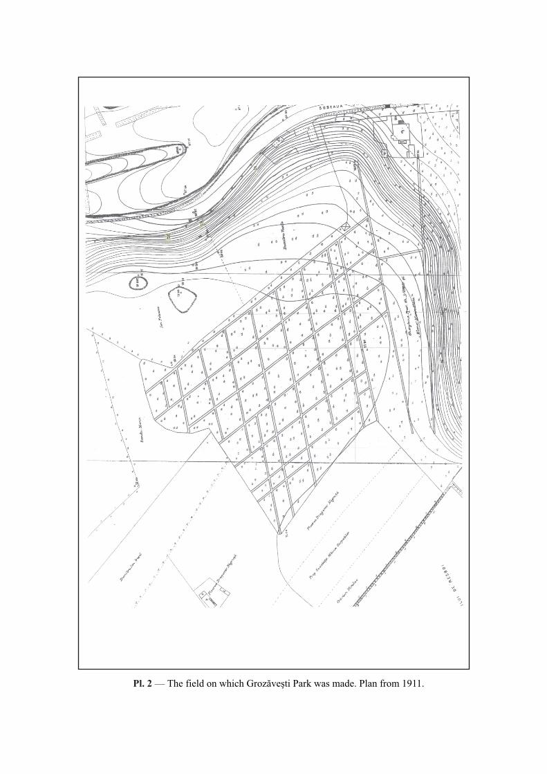
Pl. 2 — The field on which Grozăveşti Park was made. Plan from 1911.
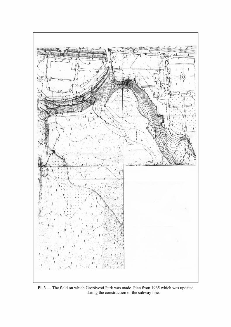
Pl. 3 — The field on which Grozăveşti Park was made. Plan from 1965 which was updated during the construction of the subway line.

Pl. 4 — The field on which Grozăveşti Park was made. Plan from 1987.
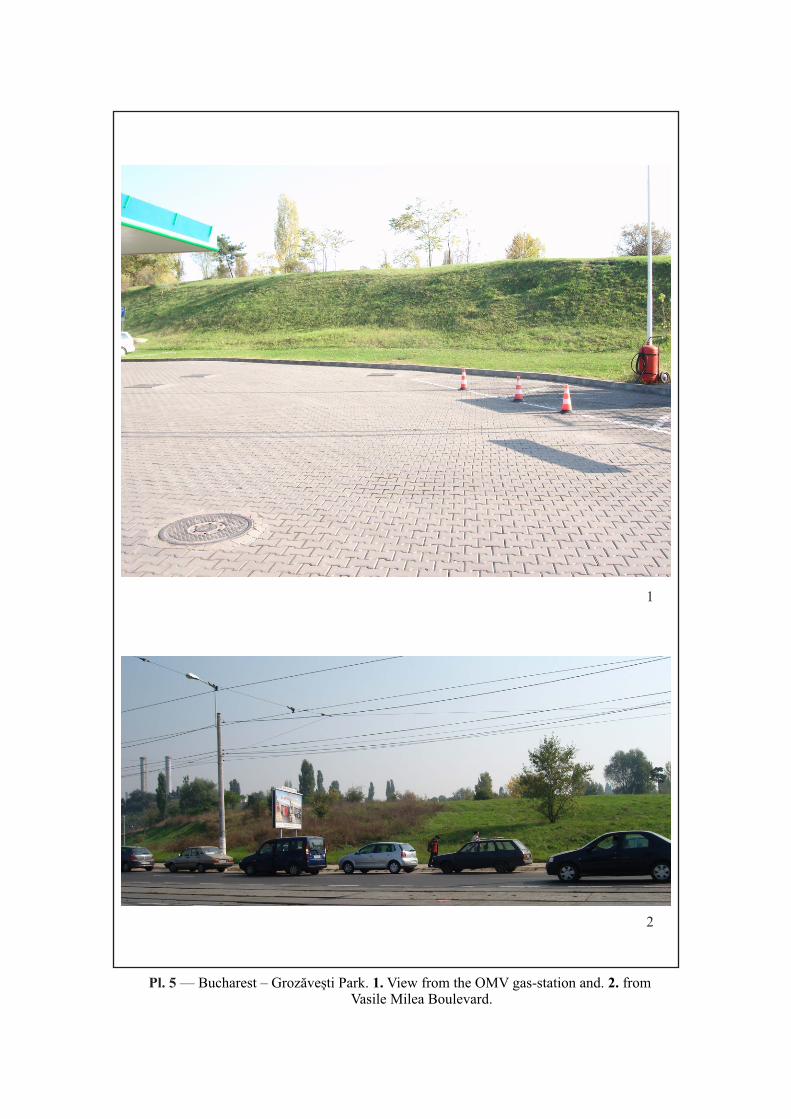
Pl. 5 — Bucharest – Grozăveşti Park. 1. View from the OMV gas-station and. 2. from Vasile Milea Boulevard.
1
2
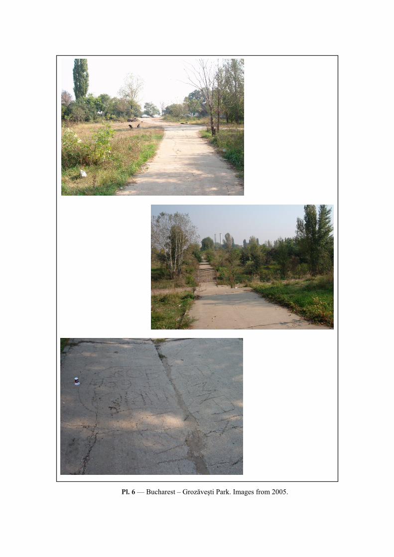
Pl. —
Pl. 6 — Bucharest – Grozăveşti Park. Images from 2005.
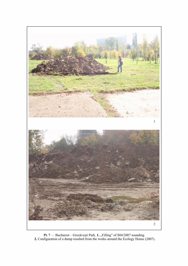
Pl. 7 — Bucharest – Grozăveşti Park. 1. „Filling” of S04/2007 sounding. 2. Configuration of a dump resulted from the works around the Ecology House (2007).
1
2
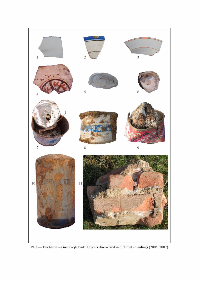
Pl. 8 — Bucharest – Grozăveşti Park. Objects discovered in different soundings (2005, 2007).
1 2 3
45 6
7 8 9
10 11
An Archaeology of the Contemporary Past: Excavations in the Grozăveşti Park, Bucharest
287
ANNEX
GEOELECTRIC RESEARCH IN THE VASILE MILEA
BOULEVARD AREA
Florian RĂDULESCU
Geoelectric measurements were
conducted between 19.10.2005–22.10.2005
in the Vasile Milea Boulevard area (Pl. 1)
covering 7500 m2. The information obtained
by prospecting covered a depth interval of 0–
3 m. The distribution of apparent resistivity
in the 0–3 m interval is illustrated in Pl. 2/1.
Recorded resistivity ranged between 10 and
35 ohmm, and the anomaly areas were
situated at an interval of 25–35 ohmm. The
maximum values areas represented
inhomogeneity within the above-mentioned
interval. A minimum value area was recorded
on the E-W axis; this was due to high soil
humidity, and possibly to the presence of a
former valley that was covered up.
In order to determine the baseline, a
geoelectric profile was conducted on the E-W
axis (Pl. 4); in this case the investigated depth
was 20 m. Data processing revealed an
average baseline depth of 8 m. This section
revealed the presence of a covered valley
around m 25–40. A map of the electric field
distribution in the area was made based on
spontaneous potential measurements (Pl.
2/2). An increase of the electric field was
recorded from the North to the South. We
made this map because the electric field
distribution might also provide useful
information.
Eng. Florian Rădulescu
S.C. Intel 91 SRL
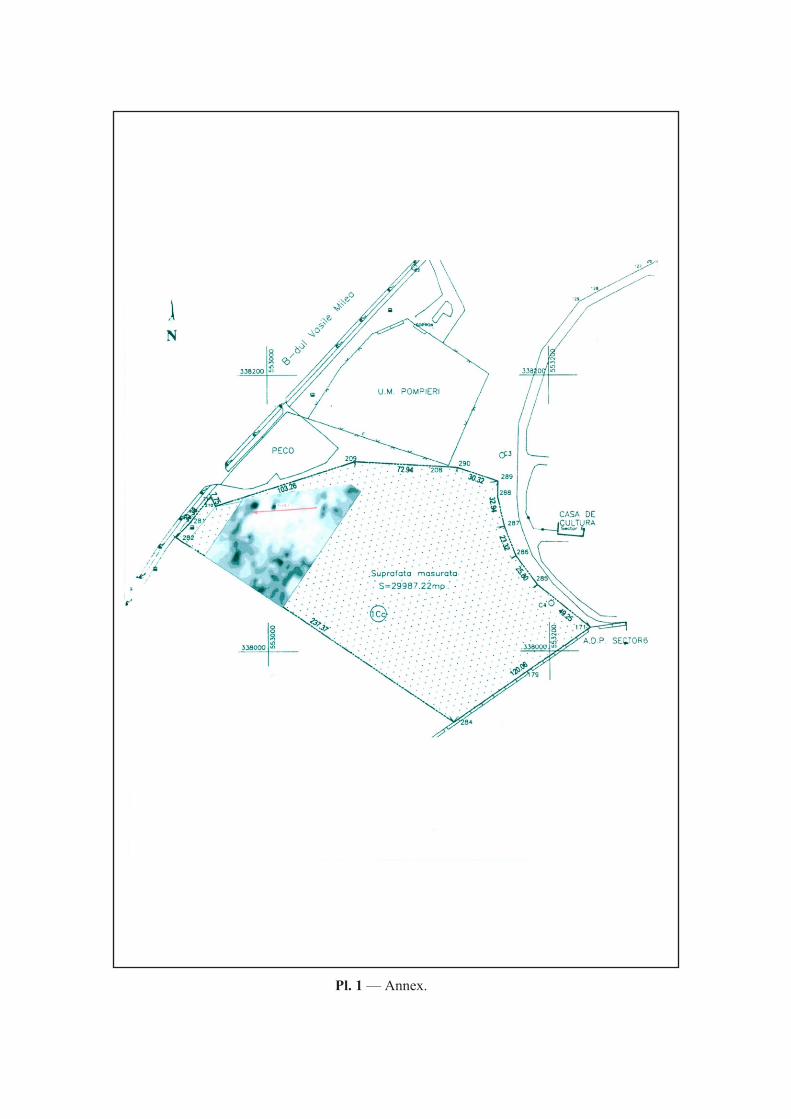
Pl. 1 — Annex.
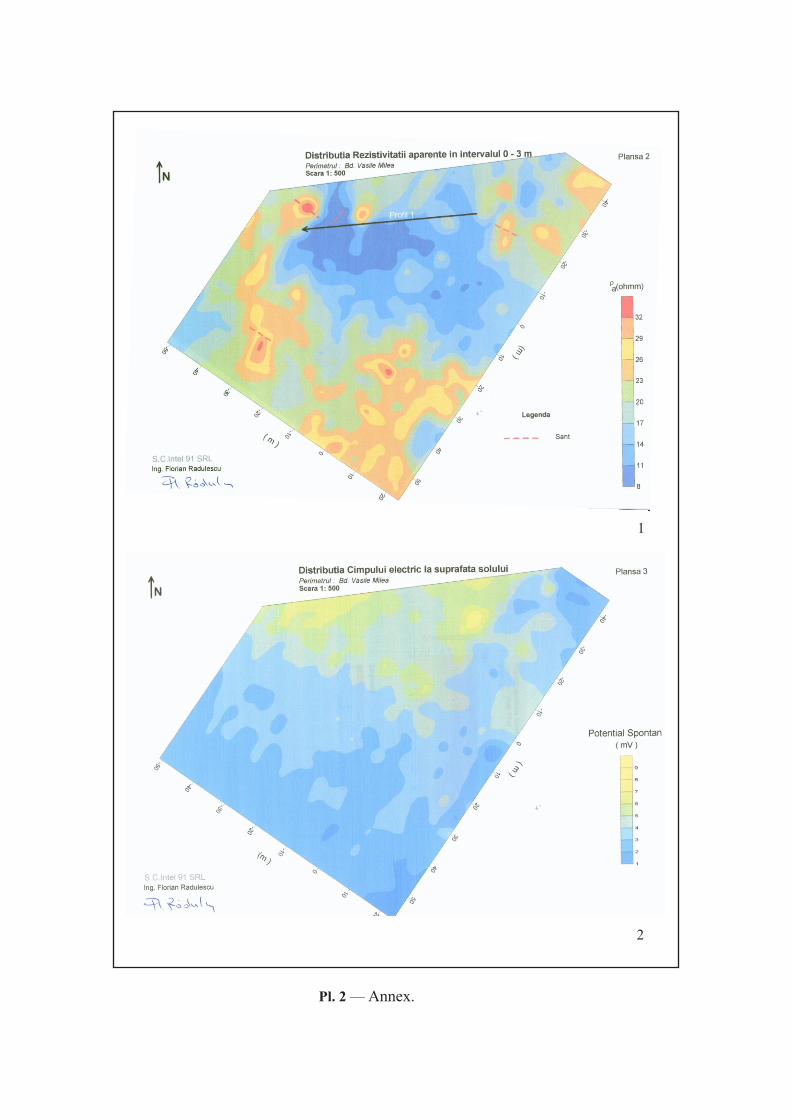
Pl. 2 — Annex.
1
2

Pl. 3 — Annex.