FIŞA DE VERIFICARE a standardelor minimale,...1 FIŞA DE VERIFICARE a standardelor minimale,...
33
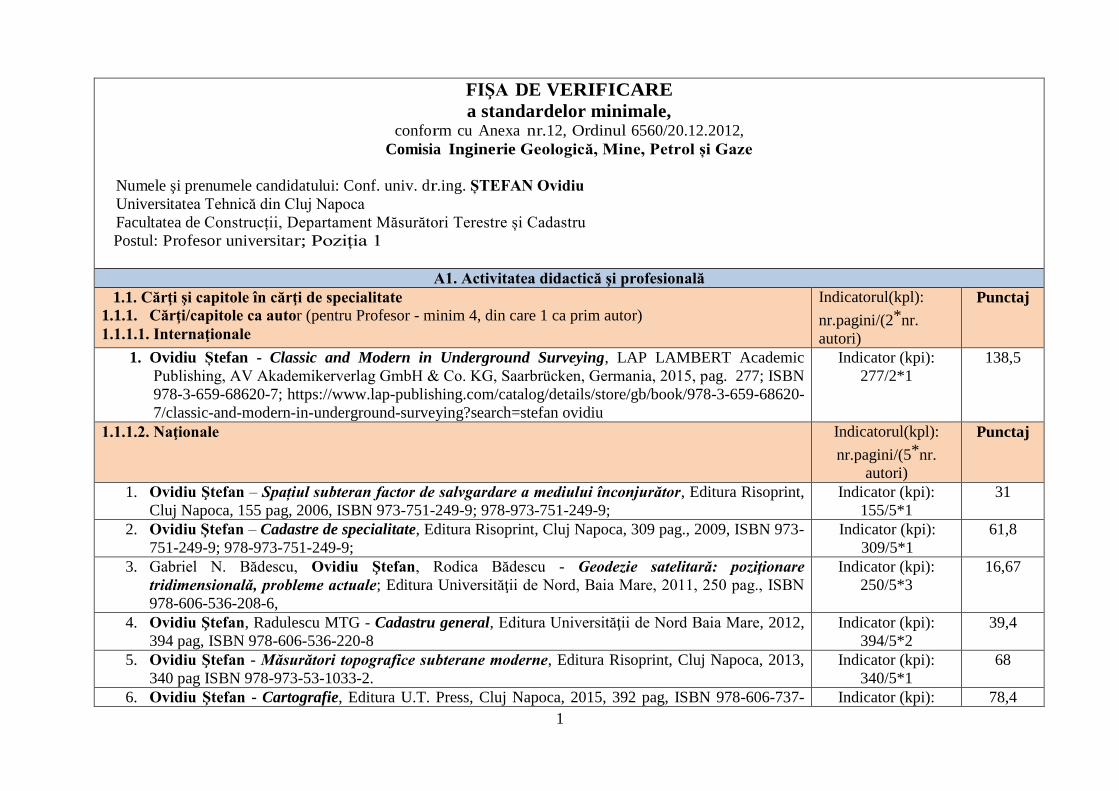
1 FIŞA DE VERIFICARE a standardelor minimale, conform cu Anexa nr.12, Ordinul 6560/20.12.2012, Comisia Inginerie Geologică, Mine, Petrol și Gaze Numele şi prenumele candidatului: Conf. univ. dr .ing. ȘTEFAN Ovidiu Universitatea Tehnică din Cluj Napoca Facultatea de Construcții, Departament Măsurători Terestre și Cadastru Postul: Profesor univer sitar; Poziția 1 A1. Activitatea didactică şi profesională 1.1. Cărţi şi capitole în cărţi de specialitate 1.1.1. Cărţi/capitole ca autor (pentru Profesor - minim 4, din care 1 ca prim autor) 1.1.1.1. Internaţionale Indicatorul(kpl): nr.pagini/(2 * nr. autori) Punctaj 1. Ovidiu Ștefan - Classic and Modern in Underground Surveying, LAP LAMBERT Academic Publishing, AV Akademikerverlag GmbH & Co. KG, Saarbrücken, Germania, 2015, pag. 277; ISBN 978-3-659-68620-7; https://www.lap-publishing.com/catalog/details/store/gb/book/978-3-659-68620- 7/classic-and-modern-in-underground-surveying?search=stefan ovidiu Indicator (kpi): 277/2*1 138,5 1.1.1.2. Naţionale Indicatorul(kpl): nr.pagini/(5 * nr. autori) Punctaj 1. Ovidiu Ştefan – Spațiul subteran factor de salvgardare a mediului înconjurător, Editura Risoprint, Cluj Napoca, 155 pag, 2006, ISBN 973-751-249-9; 978-973-751-249-9; Indicator (kpi): 155/5*1 31 2. Ovidiu Ştefan – Cadastre de specialitate, Editura Risoprint, Cluj Napoca, 309 pag., 2009, ISBN 973- 751-249-9; 978-973-751-249-9; Indicator (kpi): 309/5*1 61,8 3. Gabriel N. Bădescu, Ovidiu Ştefan, Rodica Bădescu - Geodezie satelitară: poziţionare tridimensională, probleme actuale; Editura Universităţii de Nord, Baia Mare, 2011, 250 pag., ISBN 978-606-536-208-6, Indicator (kpi): 250/5*3 16,67 4. Ovidiu Ştefan, Radulescu MTG - Cadastru general, Editura Universităţii de Nord Baia Mare, 2012, 394 pag, ISBN 978-606-536-220-8 Indicator (kpi): 394/5*2 39,4 5. Ovidiu Ştefan - Măsurători topografice subterane moderne, Editura Risoprint, Cluj Napoca, 2013, 340 pag ISBN 978-973-53-1033-2. Indicator (kpi): 340/5*1 68 6. Ovidiu Ştefan - Cartografie, Editura U.T. Press, Cluj Napoca, 2015, 392 pag, ISBN 978-606-737- Indicator (kpi): 78,4
Transcript of FIŞA DE VERIFICARE a standardelor minimale,...1 FIŞA DE VERIFICARE a standardelor minimale,...
1
FIŞA DE VERIFICARE
a standardelor minimale, conform cu Anexa nr.12, Ordinul 6560/20.12.2012,
Comisia Inginerie Geologică, Mine, Petrol și Gaze
Numele şi prenumele candidatului: Conf. univ. dr.ing. ȘTEFAN Ovidiu
Universitatea Tehnică din Cluj Napoca
Facultatea de Construcții, Departament Măsurători Terestre și Cadastru
Postul: Profesor universitar; Poziția 1
A1. Activitatea didactică şi profesională
1.1. Cărţi şi capitole în cărţi de specialitate
1.1.1. Cărţi/capitole ca autor (pentru Profesor - minim 4, din care 1 ca prim autor)
1.1.1.1. Internaţionale
Indicatorul(kpl):
nr.pagini/(2*nr.
autori)
Punctaj
1. Ovidiu Ștefan - Classic and Modern in Underground Surveying, LAP LAMBERT Academic
Publishing, AV Akademikerverlag GmbH & Co. KG, Saarbrücken, Germania, 2015, pag. 277; ISBN
978-3-659-68620-7; https://www.lap-publishing.com/catalog/details/store/gb/book/978-3-659-68620-
7/classic-and-modern-in-underground-surveying?search=stefan ovidiu
Indicator (kpi):
277/2*1
138,5
1.1.1.2. Naţionale Indicatorul(kpl):
nr.pagini/(5*nr.
autori)
Punctaj
1. Ovidiu Ştefan – Spațiul subteran factor de salvgardare a mediului înconjurător, Editura Risoprint,
Cluj Napoca, 155 pag, 2006, ISBN 973-751-249-9; 978-973-751-249-9;
Indicator (kpi):
155/5*1
31
2. Ovidiu Ştefan – Cadastre de specialitate, Editura Risoprint, Cluj Napoca, 309 pag., 2009, ISBN 973-
751-249-9; 978-973-751-249-9;
Indicator (kpi):
309/5*1
61,8
3. Gabriel N. Bădescu, Ovidiu Ştefan, Rodica Bădescu - Geodezie satelitară: poziţionare
tridimensională, probleme actuale; Editura Universităţii de Nord, Baia Mare, 2011, 250 pag., ISBN
978-606-536-208-6,
Indicator (kpi):
250/5*3
16,67
4. Ovidiu Ştefan, Radulescu MTG - Cadastru general, Editura Universităţii de Nord Baia Mare, 2012,
394 pag, ISBN 978-606-536-220-8
Indicator (kpi):
394/5*2
39,4
5. Ovidiu Ştefan - Măsurători topografice subterane moderne, Editura Risoprint, Cluj Napoca, 2013,
340 pag ISBN 978-973-53-1033-2.
Indicator (kpi):
340/5*1
68
6. Ovidiu Ştefan - Cartografie, Editura U.T. Press, Cluj Napoca, 2015, 392 pag, ISBN 978-606-737- Indicator (kpi): 78,4
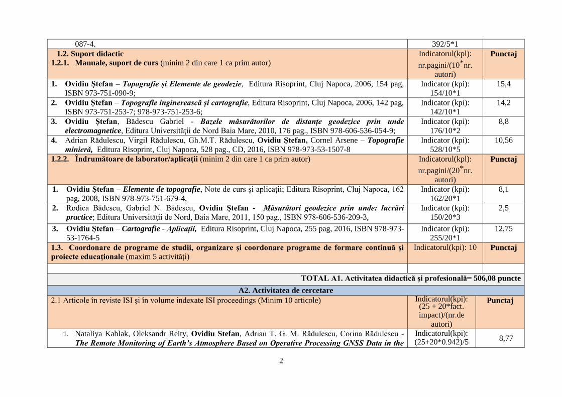
2
087-4. 392/5*1
1.2. Suport didactic 1.2.1. Manuale, suport de curs (minim 2 din care 1 ca prim autor)
Indicatorul(kpl):
nr.pagini/(10*nr.
autori)
Punctaj
1. Ovidiu Ştefan – Topografie și Elemente de geodezie, Editura Risoprint, Cluj Napoca, 2006, 154 pag,
ISBN 973-751-090-9;
Indicator (kpi):
154/10*1
15,4
2. Ovidiu Ştefan – Topografie inginerească și cartografie, Editura Risoprint, Cluj Napoca, 2006, 142 pag,
ISBN 973-751-253-7; 978-973-751-253-6;
Indicator (kpi):
142/10*1
14,2
3. Ovidiu Ştefan, Bădescu Gabriel - Bazele măsurătorilor de distanțe geodezice prin unde
electromagnetice, Editura Universităţii de Nord Baia Mare, 2010, 176 pag., ISBN 978-606-536-054-9;
Indicator (kpi):
176/10*2
8,8
4. Adrian Rădulescu, Virgil Rădulescu, Gh.M.T. Rădulescu, Ovidiu Ștefan, Cornel Arsene – Topografie
minieră, Editura Risoprint, Cluj Napoca, 528 pag., CD, 2016, ISBN 978-973-53-1507-8
Indicator (kpi):
528/10*5
10,56
1.2.2. Îndrumătoare de laborator/aplicaţii (minim 2 din care 1 ca prim autor) Indicatorul(kpl):
nr.pagini/(20*nr.
autori)
Punctaj
1. Ovidiu Ştefan – Elemente de topografie, Note de curs și aplicații; Editura Risoprint, Cluj Napoca, 162
pag, 2008, ISBN 978-973-751-679-4,
Indicator (kpi):
162/20*1
8,1
2. Rodica Bădescu, Gabriel N. Bădescu, Ovidiu Ştefan - Măsurători geodezice prin unde: lucrări
practice; Editura Universităţii de Nord, Baia Mare, 2011, 150 pag., ISBN 978-606-536-209-3,
Indicator (kpi):
150/20*3
2,5
3. Ovidiu Ștefan – Cartografie - Aplicații, Editura Risoprint, Cluj Napoca, 255 pag, 2016, ISBN 978-973-
53-1764-5
Indicator (kpi):
255/20*1
12,75
1.3. Coordonare de programe de studii, organizare şi coordonare programe de formare continuă şi
proiecte educaţionale (maxim 5 activități)
Indicatorul(kpi): 10 Punctaj
TOTAL A1. Activitatea didactică şi profesională= 506,08 puncte
A2. Activitatea de cercetare
2.1 Articole în reviste ISI şi în volume indexate ISI proceedings (Minim 10 articole) Indicatorul(kpi): (25 + 20*fact. impact)/(nr.de
autori)
Punctaj
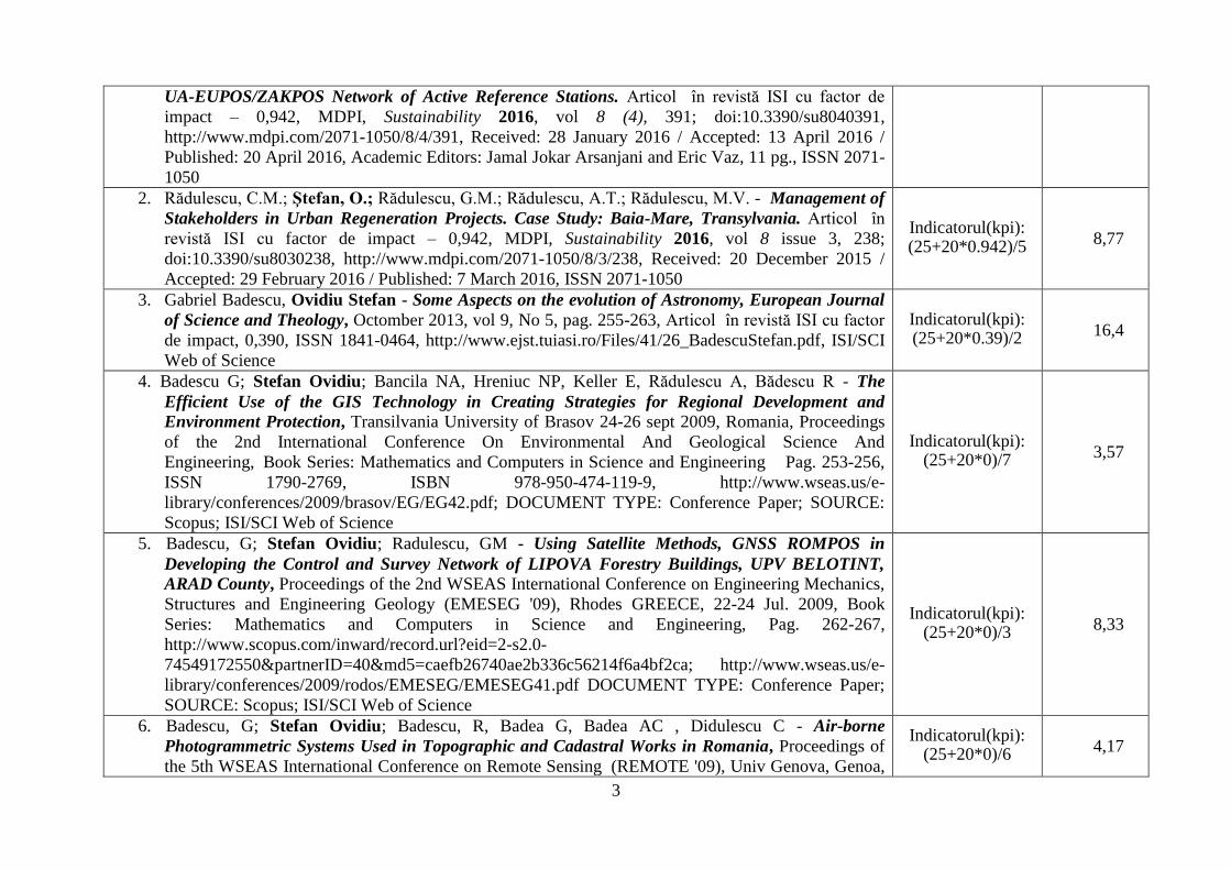
1. Nataliya Kablak, Oleksandr Reity, Ovidiu Stefan, Adrian T. G. M. Rădulescu, Corina Rădulescu -
The Remote Monitoring of Earth’s Atmosphere Based on Operative Processing GNSS Data in the
Indicatorul(kpi): (25+20*0.942)/5
8,77
3
UA-EUPOS/ZAKPOS Network of Active Reference Stations. Articol în revistă ISI cu factor de
impact – 0,942, MDPI, Sustainability 2016, vol 8 (4), 391; doi:10.3390/su8040391,
http://www.mdpi.com/2071-1050/8/4/391, Received: 28 January 2016 / Accepted: 13 April 2016 /
Published: 20 April 2016, Academic Editors: Jamal Jokar Arsanjani and Eric Vaz, 11 pg., ISSN 2071-
1050
2. Rădulescu, C.M.; Ştefan, O.; Rădulescu, G.M.; Rădulescu, A.T.; Rădulescu, M.V. - Management of
Stakeholders in Urban Regeneration Projects. Case Study: Baia-Mare, Transylvania. Articol în
revistă ISI cu factor de impact – 0,942, MDPI, Sustainability 2016, vol 8 issue 3, 238;
doi:10.3390/su8030238, http://www.mdpi.com/2071-1050/8/3/238, Received: 20 December 2015 /
Accepted: 29 February 2016 / Published: 7 March 2016, ISSN 2071-1050
Indicatorul(kpi): (25+20*0.942)/5
8,77
3. Gabriel Badescu, Ovidiu Stefan - Some Aspects on the evolution of Astronomy, European Journal
of Science and Theology, Octomber 2013, vol 9, No 5, pag. 255-263, Articol în revistă ISI cu factor
de impact, 0,390, ISSN 1841-0464, http://www.ejst.tuiasi.ro/Files/41/26_BadescuStefan.pdf, ISI/SCI
Web of Science
Indicatorul(kpi): (25+20*0.39)/2
16,4
4. Badescu G; Stefan Ovidiu; Bancila NA, Hreniuc NP, Keller E, Rădulescu A, Bădescu R - The
Efficient Use of the GIS Technology in Creating Strategies for Regional Development and
Environment Protection, Transilvania University of Brasov 24-26 sept 2009, Romania, Proceedings
of the 2nd International Conference On Environmental And Geological Science And
Engineering, Book Series: Mathematics and Computers in Science and Engineering Pag. 253-256,
ISSN 1790-2769, ISBN 978-950-474-119-9, http://www.wseas.us/e-
library/conferences/2009/brasov/EG/EG42.pdf; DOCUMENT TYPE: Conference Paper; SOURCE:
Scopus; ISI/SCI Web of Science
Indicatorul(kpi): (25+20*0)/7 3,57
5. Badescu, G; Stefan Ovidiu; Radulescu, GM - Using Satellite Methods, GNSS ROMPOS in
Developing the Control and Survey Network of LIPOVA Forestry Buildings, UPV BELOTINT,
ARAD County, Proceedings of the 2nd WSEAS International Conference on Engineering Mechanics,
Structures and Engineering Geology (EMESEG '09), Rhodes GREECE, 22-24 Jul. 2009, Book
Series: Mathematics and Computers in Science and Engineering, Pag. 262-267,
http://www.scopus.com/inward/record.url?eid=2-s2.0-
74549172550&partnerID=40&md5=caefb26740ae2b336c56214f6a4bf2ca; http://www.wseas.us/e-
library/conferences/2009/rodos/EMESEG/EMESEG41.pdf DOCUMENT TYPE: Conference Paper;
SOURCE: Scopus; ISI/SCI Web of Science
Indicatorul(kpi): (25+20*0)/3
8,33
6. Badescu, G; Stefan Ovidiu; Badescu, R, Badea G, Badea AC , Didulescu C - Air-borne
Photogrammetric Systems Used in Topographic and Cadastral Works in Romania, Proceedings of
the 5th WSEAS International Conference on Remote Sensing (REMOTE '09), Univ Genova, Genoa,
Indicatorul(kpi): (25+20*0)/6
4,17
4
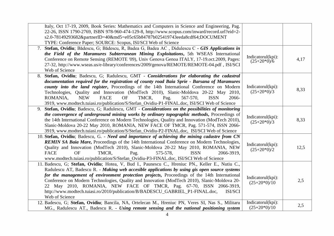
Italy, Oct 17-19, 2009, Book Series: Mathematics and Computers in Science and Engineering, Pag.
22-26, ISSN 1790-2769, ISBN 978-960-474-129-8, http://www.scopus.com/inward/record.url?eid=2-
s2.0-78149293682&partnerID=40&md5=e05c65b84787b025419743eeda8cdf64;DOCUMENT
TYPE: Conference Paper; SOURCE: Scopus, ISI/SCI Web of Science
7. Stefan, Ovidiu; Bădescu, G; Bădescu, R, Badea G, Badea AC , Didulescu C - GIS Applications in
the Field of the Maramures Subterranean Mining Exploitations, 5th WSEAS International
Conference on Remote Sensing (REMOTE '09), Univ Genova Genoa ITALY, 17-19.oct.2009, Pages:
27-32, http://www.wseas.us/e-library/conferences/2009/genova/REMOTE/REMOTE-04.pdf , ISI/SCI
Web of Science
Indicatorul(kpi): (25+20*0)/6 4,17
8. Stefan, Ovidiu; Badescu, G; Radulescu, GMT - Considerations for elaborating the cadastral
documentation required for the registration of county road Baia Sprie - Barsana of Maramures
county into the land register, Proceedings of the 14th International Conference on Modern
Technologies, Quality and Innovation (ModTech 2010), Slanic-Moldova 20-22 May 2010,
ROMANIA, NEW FACE OF TMCR, Pag. 567-570, ISSN 2066-
3919, www.modtech.tuiasi.ro/publication/S/Stefan_Ovidiu-P1-FINAL.doc, ISI/SCI Web of Science
Indicatorul(kpi): (25+20*0)/3 8,33
9. Stefan, Ovidiu; Badescu, G; Radulescu, GMT - Considerations on the possibilities of monitoring
the convergence of underground mining works by ordinary topographic methods, Proceedings of
the 14th International Conference on Modern Technologies, Quality and Innovation (ModTech 2010),
Slanic-Moldova 20-22 May 2010, ROMANIA, NEW FACE OF TMCR, Pag. 571-574, ISSN 2066-
3919, www.modtech.tuiasi.ro/publication/S/Stefan_Ovidiu-P2-FINAL.doc, ISI/SCI Web of Science
Indicatorul(kpi): (25+20*0)/3
8,33
10. Stefan, Ovidiu; Badescu, G. - Need and importance of achieving the mining cadastre from CN
REMIN SA Baia Mare, Proceedings of the 14th International Conference on Modern Technologies,
Quality and Innovation (ModTech 2010), Slanic-Moldova 20-22 May 2010, ROMANIA, NEW
FACE OF TMCR, Pag. 575-578, ISSN 2066-3919,
www.modtech.tuiasi.ro/publication/S/Stefan_Ovidiu-P3-FINAL.doc, ISI/SCI Web of Science
Indicatorul(kpi): (25+20*0)/2
12,5
11. Badescu, G; Stefan, Ovidiu; Hotea, V, Bud I., Paunescu C., Hreniuc PN., Keller E., Nutiu C.,
Radulescu AT, Badescu R. - Making web accesible applications by using gis open source systems
for the management of environment protection projects, Proceedings of the 14th International
Conference on Modern Technologies, Quality and Innovation (ModTech 2010), Slanic-Moldova 20-
22 May 2010, ROMANIA, NEW FACE OF TMCR, Pag. 67-70, ISSN 2066-3919,
http://www.modtech.tuiasi.ro/2010/publication/B/BADESCU_GABRIEL_P1-FINAL.doc, ISI/SCI
Web of Science
Indicatorul(kpi): (25+20*0)/10
2,5
12. Badescu, G; Stefan, Ovidiu; Bancila, NA, Ortelecan M., Hreniuc PN, Veres SI, Nas S., Militaru
MG., Radulescu AT., Badescu R. - Using remote sensing and the national positioning system
Indicatorul(kpi): (25+20*0)/10
2,5

5
ROMPOS GNSS in the projects for sustainable development and environment protection, Proceedings of the 14th International Conference on Modern Technologies, Quality and Innovation
(ModTech 2010), Slanic-Moldova 20-22 May 2010, ROMANIA, NEW FACE OF TMCR, Pages: 71-
74, ISSN 2066-3919, http://www.modtech.tuiasi.ro/2010/publication/B/BADESCU_GABRIEL_P2-
FINAL.doc, ISI/SCI Web of Science
13. Bădescu GABRIEL, Stefan OVIDIU, Pop NICOLAE, Vereş SAMUEL IOEL, Ortelecan MIRCEA,
Bădescu RODICA - Using neural networks for dynamic vehicle navigation using integrated GNSS
/ INS your Romania, Proceedings of the International Conference on Instrumentation, Measurement,
Circuits and Systems (ICIMCS 2011), December 12–13, 2011, Hong Kong, China,
http://ebooks.asmedigitalcollection.asme.org/content.aspx?bookid=405§ionid=38787013, VOL
2: Future Communication And Networking, Pages: 23-26, Published: 2011, Document Type:
Proceedings Paper, Language:English, Accession Number: WOS:000306295600006, ISBN:978-0-
7918-5990-2,
http://ebooks.asmedigitalcollection.asme.org/content.aspx?bookid=405§ionid=38787013&result
Click=1, DOI: 10.1115/1.859902.paper113, Scopus; ISI/SCI Web of Science
Indicatorul(kpi): (25+20*0)/6
4,17
14. Badescu, G ; Badescu, R; Stefan, Ovidiu; Hotea, V. - Some issues in using RTK GPS technology
and ROMPOS in Agriculture, Conference: International Conference on Agricultural and Biosystems
Engineering, 20-21 FEB 2011, Hong Kong, CHINA, Book Series: Advances in Biomedical
Engineering, Pag. 445-448, Publisher: INFORMATION ENGINEERING RESEARCH INST, USA,
100 CONTINENTAL DR, NEWARK, DE 19713 USA IDS Number: BUK55, ISSN: 2160-0589,
ISBN: 978-1-4244-9216-9, http://www.ieee-peits.com/icabe/index.htm,
http://anelis1.summon.serialssolutions.com.ux4ll8xu6v.useaccesscontrol.com/#!/search?ho=f&q=Som
e%20issues%20in%20using%20RTK%20GPS%20technology%20and%20ROMPOS%20in%20Agric
ulture&l=en; ISI/SCI Web of Science
Indicatorul(kpi): (25+20*0)/4
6,25
15. Badescu, G ; Badescu, R; Stefan, Ovidiu ; Ortelecan, M ; Pop, N ; Ciotlaus, A; Luput, L - 2011-
Using GPS-GNSS global positioning systems in agriculture, Conference: International Conference
on Agricultural and Biosystems Engineering, 20-21 FEB 2011, Hong Kong, CHINA, Book Series:
Advances in Biomedical Engineering, Pag. 449-452, Publisher: INFORMATION ENGINEERING
RESEARCH INST, USA, 100 CONTINENTAL DR, NEWARK, DE 19713 USA IDS Number:
BUK55, ISSN: 2160-0589, ISBN: 978-1-4244-9216-9, http://www.ier-institute.org/mime/index.htm;
http://anelis1.summon.serialssolutions.com.ux4ll8xu6v.useaccesscontrol.com/#!/search?ho=f&q=Usi
ng%20GPS-GNSS%20Global%20Positioning%20Systems%20in%20&l=en; ISI/SCI Web of
Science
Indicatorul(kpi): (25+20*0)/7
3,57
16. Badescu, G ; Badescu, R ; Stefan, Ovidiu; Didulescu, C ; Veres, IS ; Paunescu, C - Studies and Indicatorul(kpi): 4,17
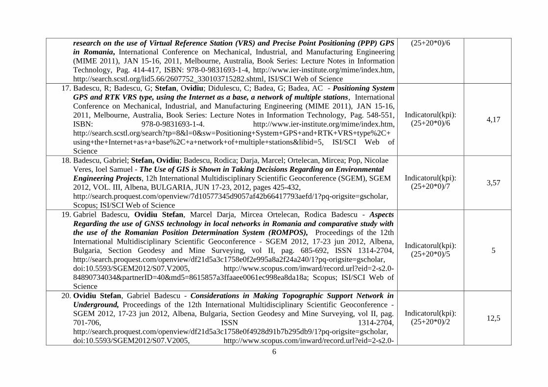
6
research on the use of Virtual Reference Station (VRS) and Precise Point Positioning (PPP) GPS
in Romania, International Conference on Mechanical, Industrial, and Manufacturing Engineering
(MIME 2011), JAN 15-16, 2011, Melbourne, Australia, Book Series: Lecture Notes in Information
Technology, Pag. 414-417, ISBN: 978-0-9831693-1-4, http://www.ier-institute.org/mime/index.htm,
http://search.scstl.org/lid5.66/2607752_330103715282.shtml, ISI/SCI Web of Science
(25+20*0)/6
17. Badescu, R; Badescu, G; Stefan, Ovidiu; Didulescu, C; Badea, G; Badea, AC - Positioning System
GPS and RTK VRS type, using the Internet as a base, a network of multiple stations, International
Conference on Mechanical, Industrial, and Manufacturing Engineering (MIME 2011), JAN 15-16,
2011, Melbourne, Australia, Book Series: Lecture Notes in Information Technology, Pag. 548-551,
ISBN: 978-0-9831693-1-4. http://www.ier-institute.org/mime/index.htm,
http://search.scstl.org/search?tp=8&l=0&sw=Positioning+System+GPS+and+RTK+VRS+type%2C+
using+the+Internet+as+a+base%2C+a+network+of+multiple+stations&libid=5, ISI/SCI Web of
Science
Indicatorul(kpi): (25+20*0)/6
4,17
18. Badescu, Gabriel; Stefan, Ovidiu; Badescu, Rodica; Darja, Marcel; Ortelecan, Mircea; Pop, Nicolae
Veres, Ioel Samuel - The Use of GIS is Shown in Taking Decisions Regarding on Environmental
Engineering Projects, 12h International Multidisciplinary Scientific Geoconference (SGEM), SGEM
2012, VOL. III, Albena, BULGARIA, JUN 17-23, 2012, pages 425-432,
http://search.proquest.com/openview/7d10577345d9057af42b66417793aefd/1?pq-origsite=gscholar,
Scopus; ISI/SCI Web of Science
Indicatorul(kpi): (25+20*0)/7
3,57
19. Gabriel Badescu, Ovidiu Stefan, Marcel Darja, Mircea Ortelecan, Rodica Badescu - Aspects
Regarding the use of GNSS technology in local networks in Romania and comparative study with
the use of the Romanian Position Determination System (ROMPOS), Proceedings of the 12th
International Multidisciplinary Scientific Geoconference - SGEM 2012, 17-23 jun 2012, Albena,
Bulgaria, Section Geodesy and Mine Surveying, vol II, pag. 685-692, ISSN 1314-2704,
http://search.proquest.com/openview/df21d5a3c1758e0f2e995a8a2f24a240/1?pq-origsite=gscholar,
doi:10.5593/SGEM2012/S07.V2005, http://www.scopus.com/inward/record.url?eid=2-s2.0-
84890734034&partnerID=40&md5=8615857a3ffaaee0061ec998ea8da18a; Scopus; ISI/SCI Web of
Science
Indicatorul(kpi): (25+20*0)/5
5
20. Ovidiu Stefan, Gabriel Badescu - Considerations in Making Topographic Support Network in
Underground, Proceedings of the 12th International Multidisciplinary Scientific Geoconference -
SGEM 2012, 17-23 jun 2012, Albena, Bulgaria, Section Geodesy and Mine Surveying, vol II, pag.
701-706, ISSN 1314-2704,
http://search.proquest.com/openview/df21d5a3c1758e0f4928d91b7b295db9/1?pq-origsite=gscholar,
doi:10.5593/SGEM2012/S07.V2005, http://www.scopus.com/inward/record.url?eid=2-s2.0-
Indicatorul(kpi): (25+20*0)/2
12,5
7
84890765959&partnerID=40&md5=9e1d2c058706e9f759377612c146a075; Scopus, ISI/SCI Web of
Science
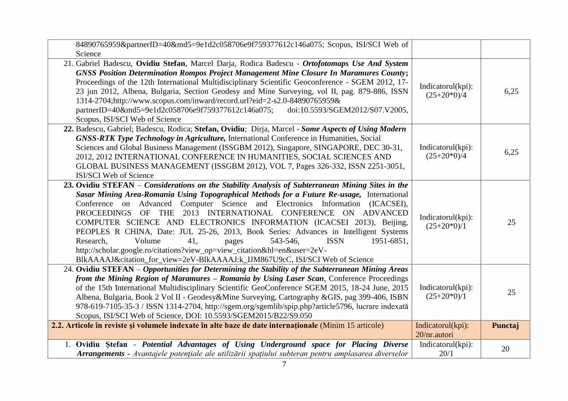
21. Gabriel Badescu, Ovidiu Stefan, Marcel Darja, Rodica Badescu - Ortofotomaps Use And System
GNSS Position Determination Rompos Project Management Mine Closure In Maramures County; Proceedings of the 12th International Multidisciplinary Scientific Geoconference - SGEM 2012, 17-
23 jun 2012, Albena, Bulgaria, Section Geodesy and Mine Surveying, vol II, pag. 879-886, ISSN
1314-2704;http://www.scopus.com/inward/record.url?eid=2-s2.0-84890765959&
partnerID=40&md5=9e1d2c058706e9f759377612c146a075; doi:10.5593/SGEM2012/S07.V2005,
Scopus, ISI/SCI Web of Science
Indicatorul(kpi): (25+20*0)/4
6,25
22. Badescu, Gabriel; Badescu, Rodica; Stefan, Ovidiu; Dirja, Marcel - Some Aspects of Using Modern
GNSS-RTK Type Technology in Agriculture, International Conference in Humanities, Social
Sciences and Global Business Management (ISSGBM 2012), Singapore, SINGAPORE, DEC 30-31,
2012, 2012 INTERNATIONAL CONFERENCE IN HUMANITIES, SOCIAL SCIENCES AND
GLOBAL BUSINESS MANAGEMENT (ISSGBM 2012), VOL 7, Pages 326-332, ISSN 2251-3051,
ISI/SCI Web of Science
Indicatorul(kpi): (25+20*0)/4 6,25
23. Ovidiu STEFAN – Considerations on the Stability Analysis of Subterranean Mining Sites in the
Sasar Mining Area-Romania Using Topographical Methods for a Future Re-usage, International
Conference on Advanced Computer Science and Electronics Information (ICACSEI),
PROCEEDINGS OF THE 2013 INTERNATIONAL CONFERENCE ON ADVANCED
COMPUTER SCIENCE AND ELECTRONICS INFORMATION (ICACSEI 2013), Beijing,
PEOPLES R CHINA, Date: JUL 25-26, 2013, Book Series: Advances in Intelligent Systems
Research, Volume 41, pages 543-546, ISSN 1951-6851,
http://scholar.google.ro/citations?view_op=view_citation&hl=en&user=2eV-
BlkAAAAJ&citation_for_view=2eV-BlkAAAAJ:k_IJM867U9cC, ISI/SCI Web of Science
Indicatorul(kpi): (25+20*0)/1
25
24. Ovidiu STEFAN – Opportunities for Determining the Stability of the Subterranean Mining Areas
from the Mining Region of Maramures – Romania by Using Laser Scan, Conference Proceedings
of the 15th International Multidisciplinary Scientific GeoConference SGEM 2015, 18-24 June, 2015
Albena, Bulgaria, Book 2 Vol II - Geodesy&Mine Surveying, Cartography &GIS, pag 399-406, ISBN
978-619-7105-35-3 / ISSN 1314-2704, http://sgem.org/sgemlib/spip.php?article5796, lucrare indexată
Scopus, ISI/SCI Web of Science, DOI: 10.5593/SGEM2015/B22/S9.050
Indicatorul(kpi): (25+20*0)/1
25
2.2. Articole în reviste şi volumele indexate în alte baze de date internaţionale (Minim 15 articole) Indicatorul(kpi):
20/nr.autori Punctaj
1. Ovidiu Ştefan - Potential Advantages of Using Underground space for Placing Diverse
Arrangements - Avantajele potenţiale ale utilizării spaţiului subteran pentru amplasarea diverselor
Indicatorul(kpi):
20/1 20
8
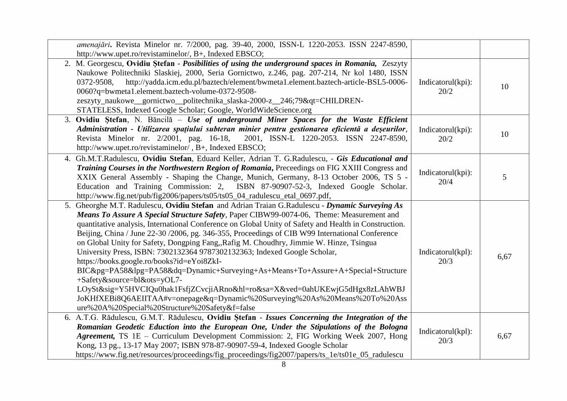
amenajări. Revista Minelor nr. 7/2000, pag. 39-40, 2000, ISSN-L 1220-2053. ISSN 2247-8590,
http://www.upet.ro/revistaminelor/, B+, Indexed EBSCO;
2. M. Georgescu, Ovidiu Ştefan - Posibilities of using the underground spaces in Romania, Zeszyty
Naukowe Politechniki Slaskiej, 2000, Seria Gornictwo, z.246, pag. 207-214, Nr kol 1480, ISSN
0372-9508, http://yadda.icm.edu.pl/baztech/element/bwmeta1.element.baztech-article-BSL5-0006-
0060?q=bwmeta1.element.baztech-volume-0372-9508-
zeszyty_naukowe__gornictwo__politechnika_slaska-2000-z__246;79&qt=CHILDREN-
STATELESS, Indexed Google Scholar; Google, WorldWideScience.org
Indicatorul(kpi):
20/2 10
3. Ovidiu Ştefan, N. Băncilă – Use of underground Miner Spaces for the Waste Efficient
Administration - Utilizarea spaţiului subteran minier pentru gestionarea eficientă a deşeurilor,
Revista Minelor nr. 2/2001, pag. 16-18, 2001, ISSN-L 1220-2053. ISSN 2247-8590,
http://www.upet.ro/revistaminelor/ , B+, Indexed EBSCO;
Indicatorul(kpi):
20/2 10
4. Gh.M.T.Radulescu, Ovidiu Stefan, Eduard Keller, Adrian T. G.Radulescu, - Gis Educational and
Training Courses in the Northwestern Region of Romania, Preceedings on FIG XXIII Congress and
XXIX General Assembly - Shaping the Change, Munich, Germany, 8-13 October 2006, TS 5 -
Education and Training Commission: 2, ISBN 87-90907-52-3, Indexed Google Scholar.
http://www.fig.net/pub/fig2006/papers/ts05/ts05_04_radulescu_etal_0697.pdf,
Indicatorul(kpi):
20/4 5
5. Gheorghe M.T. Radulescu, Ovidiu Stefan and Adrian Traian G.Radulescu - Dynamic Surveying As
Means To Assure A Special Structure Safety, Paper CIBW99-0074-06, Theme: Measurement and
quantitative analysis, International Conference on Global Unity of Safety and Health in Construction.
Beijing, China / June 22-30 /2006, pg. 346-355, Proceedings of CIB W99 International Conference
on Global Unity for Safety, Dongping Fang,,Rafig M. Choudhry, Jimmie W. Hinze, Tsingua
University Press, ISBN: 7302132364 9787302132363; Indexed Google Scholar,
https://books.google.ro/books?id=eYoi8ZkI-
BIC&pg=PA58&lpg=PA58&dq=Dynamic+Surveying+As+Means+To+Assure+A+Special+Structure
+Safety&source=bl&ots=yOL7-
LOySt&sig=Y5HVCIQu0hak1FsfjZCvcjiARno&hl=ro&sa=X&ved=0ahUKEwjG5dHgx8zLAhWBJ
JoKHfXEBi8Q6AEIITAA#v=onepage&q=Dynamic%20Surveying%20As%20Means%20To%20Ass
ure%20A%20Special%20Structure%20Safety&f=false
Indicatorul(kpl):
20/3 6,67
6. A.T.G. Rădulescu, G.M.T. Rădulescu, Ovidiu Ştefan - Issues Concerning the Integration of the
Romanian Geodetic Eduction into the European One, Under the Stipulations of the Bologna
Agreement, TS 1E – Curriculum Development Commission: 2, FIG Working Week 2007, Hong
Kong, 13 pg., 13-17 May 2007; ISBN 978-87-90907-59-4, Indexed Google Scholar
https://www.fig.net/resources/proceedings/fig_proceedings/fig2007/papers/ts_1e/ts01e_05_radulescu
Indicatorul(kpl):
20/3 6,67
9
_etal_1249.pdf
7. Gheorghe M.T.Rădulescu, Adrian T.G.Rădulescu, Ovidiu Ştefan, - As mean to Assure Structure
Safety-Dynamic Surveying, Conference GEOS 2008 The 3rd Conference and 3rd International Trade
Fair of Geodesy, Cartography, Navigation and Geoinformatics, 28-1 March 2008, Prague, Czech
Republic, lucrare publicată în volumul conferinţei pag. 217-229,
https://www.yumpu.com/en/document/view/32917666/as-means-to-assure-structure-safety-dynamic-
surveying-zajiatana, Indexed Google Scholar;
Indicatorul(kpi):
20/3 6,67
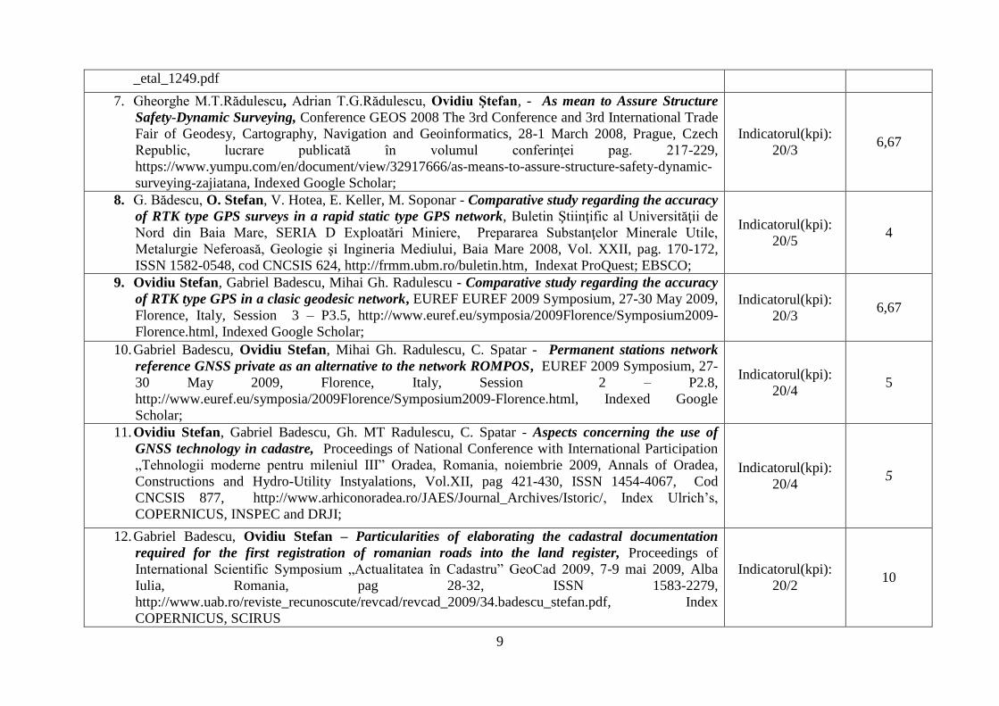
8. G. Bădescu, O. Stefan, V. Hotea, E. Keller, M. Soponar - Comparative study regarding the accuracy
of RTK type GPS surveys in a rapid static type GPS network, Buletin Ştiinţific al Universităţii de
Nord din Baia Mare, SERIA D Exploatări Miniere, Prepararea Substanţelor Minerale Utile,
Metalurgie Neferoasă, Geologie şi Ingineria Mediului, Baia Mare 2008, Vol. XXII, pag. 170-172,
ISSN 1582-0548, cod CNCSIS 624, http://frmm.ubm.ro/buletin.htm, Indexat ProQuest; EBSCO;
Indicatorul(kpi):
20/5 4
9. Ovidiu Stefan, Gabriel Badescu, Mihai Gh. Radulescu - Comparative study regarding the accuracy
of RTK type GPS in a clasic geodesic network, EUREF EUREF 2009 Symposium, 27-30 May 2009,
Florence, Italy, Session 3 – P3.5, http://www.euref.eu/symposia/2009Florence/Symposium2009-
Florence.html, Indexed Google Scholar;
Indicatorul(kpi):
20/3 6,67
10. Gabriel Badescu, Ovidiu Stefan, Mihai Gh. Radulescu, C. Spatar - Permanent stations network
reference GNSS private as an alternative to the network ROMPOS, EUREF 2009 Symposium, 27-
30 May 2009, Florence, Italy, Session 2 – P2.8,
http://www.euref.eu/symposia/2009Florence/Symposium2009-Florence.html, Indexed Google
Scholar;
Indicatorul(kpi):
20/4 5
11. Ovidiu Stefan, Gabriel Badescu, Gh. MT Radulescu, C. Spatar - Aspects concerning the use of
GNSS technology in cadastre, Proceedings of National Conference with International Participation
„Tehnologii moderne pentru mileniul III” Oradea, Romania, noiembrie 2009, Annals of Oradea,
Constructions and Hydro-Utility Instyalations, Vol.XII, pag 421-430, ISSN 1454-4067, Cod
CNCSIS 877, http://www.arhiconoradea.ro/JAES/Journal_Archives/Istoric/, Index Ulrich’s,
COPERNICUS, INSPEC and DRJI;
Indicatorul(kpi):
20/4 5
12. Gabriel Badescu, Ovidiu Stefan – Particularities of elaborating the cadastral documentation
required for the first registration of romanian roads into the land register, Proceedings of
International Scientific Symposium „Actualitatea în Cadastru” GeoCad 2009, 7-9 mai 2009, Alba
Iulia, Romania, pag 28-32, ISSN 1583-2279,
http://www.uab.ro/reviste_recunoscute/revcad/revcad_2009/34.badescu_stefan.pdf, Index
COPERNICUS, SCIRUS
Indicatorul(kpi):
20/2 10
10
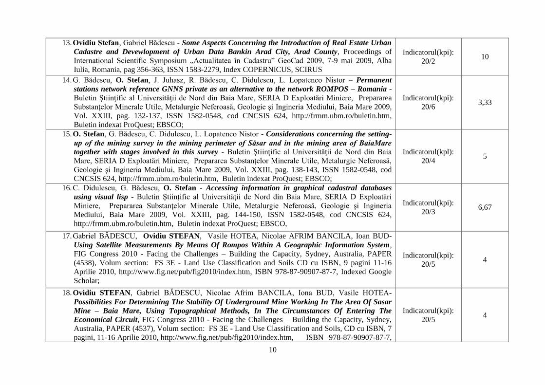
13. Ovidiu Ștefan, Gabriel Bădescu - Some Aspects Concerning the Introduction of Real Estate Urban
Cadastre and Devewlopment of Urban Data Bankin Arad City, Arad County, Proceedings of
International Scientific Symposium „Actualitatea în Cadastru” GeoCad 2009, 7-9 mai 2009, Alba
Iulia, Romania, pag 356-363, ISSN 1583-2279, Index COPERNICUS, SCIRUS
Indicatorul(kpi):
20/2 10
14. G. Bădescu, O. Stefan, J. Juhasz, R. Bădescu, C. Didulescu, L. Lopatenco Nistor – Permanent
stations network reference GNNS private as an alternative to the network ROMPOS – Romania -
Buletin Ştiinţific al Universităţii de Nord din Baia Mare, SERIA D Exploatări Miniere, Prepararea
Substanţelor Minerale Utile, Metalurgie Neferoasă, Geologie şi Ingineria Mediului, Baia Mare 2009,
Vol. XXIII, pag. 132-137, ISSN 1582-0548, cod CNCSIS 624, http://frmm.ubm.ro/buletin.htm,
Buletin indexat ProQuest; EBSCO;
Indicatorul(kpi):
20/6 3,33
15. O. Stefan, G. Bădescu, C. Didulescu, L. Lopatenco Nistor - Considerations concerning the setting-
up of the mining survey in the mining perimeter of Săsar and in the mining area of BaiaMare
together with stages involved in this survey - Buletin Ştiinţific al Universităţii de Nord din Baia
Mare, SERIA D Exploatări Miniere, Prepararea Substanţelor Minerale Utile, Metalurgie Neferoasă,
Geologie şi Ingineria Mediului, Baia Mare 2009, Vol. XXIII, pag. 138-143, ISSN 1582-0548, cod
CNCSIS 624, http://frmm.ubm.ro/buletin.htm, Buletin indexat ProQuest; EBSCO;
Indicatorul(kpl):
20/4 5
16. C. Didulescu, G. Bădescu, O. Stefan - Accessing information in graphical cadastral databases
using visual lisp - Buletin Ştiinţific al Universităţii de Nord din Baia Mare, SERIA D Exploatări
Miniere, Prepararea Substanţelor Minerale Utile, Metalurgie Neferoasă, Geologie şi Ingineria
Mediului, Baia Mare 2009, Vol. XXIII, pag. 144-150, ISSN 1582-0548, cod CNCSIS 624,
http://frmm.ubm.ro/buletin.htm, Buletin indexat ProQuest; EBSCO,
Indicatorul(kpi):
20/3 6,67
17. Gabriel BĂDESCU, Ovidiu STEFAN, Vasile HOTEA, Nicolae AFRIM BANCILA, Ioan BUD-
Using Satellite Measurements By Means Of Rompos Within A Geographic Information System,
FIG Congress 2010 - Facing the Challenges – Building the Capacity, Sydney, Australia, PAPER
(4538), Volum section: FS 3E - Land Use Classification and Soils CD cu ISBN, 9 pagini 11-16
Aprilie 2010, http://www.fig.net/pub/fig2010/index.htm, ISBN 978-87-90907-87-7, Indexed Google
Scholar;
Indicatorul(kpi):
20/5 4
18. Ovidiu STEFAN, Gabriel BĂDESCU, Nicolae Afrim BANCILA, Iona BUD, Vasile HOTEA-
Possibilities For Determining The Stability Of Underground Mine Working In The Area Of Sasar
Mine – Baia Mare, Using Topographical Methods, In The Circumstances Of Entering The
Economical Circuit, FIG Congress 2010 - Facing the Challenges – Building the Capacity, Sydney,
Australia, PAPER (4537), Volum section: FS 3E - Land Use Classification and Soils, CD cu ISBN, 7
pagini, 11-16 Aprilie 2010, http://www.fig.net/pub/fig2010/index.htm, ISBN 978-87-90907-87-7,
Indicatorul(kpi):
20/5 4
11
Indexed Google Scholar;
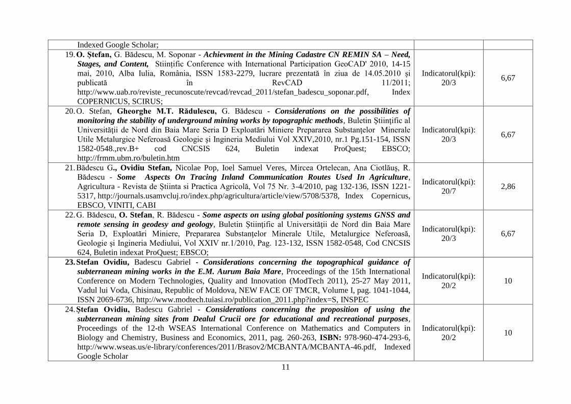
19. O. Ștefan, G. Bădescu, M. Soponar - Achievment in the Mining Cadastre CN REMIN SA – Need,
Stages, and Content, Stiințific Conference with International Participation GeoCAD' 2010, 14-15
mai, 2010, Alba Iulia, România, ISSN 1583-2279, lucrare prezentată în ziua de 14.05.2010 şi
publicată în RevCAD 11/2011;
http://www.uab.ro/reviste_recunoscute/revcad/revcad_2011/stefan_badescu_soponar.pdf, Index
COPERNICUS, SCIRUS;
Indicatorul(kpi):
20/3 6,67
20. O. Stefan, Gheorghe M.T. Rădulescu, G. Bădescu - Considerations on the possibilities of
monitoring the stability of underground mining works by topographic methods, Buletin Ştiinţific al
Universităţii de Nord din Baia Mare Seria D Exploatări Miniere Prepararea Substanţelor Minerale
Utile Metalurgice Neferoasă Geologie şi Ingineria Mediului Vol XXIV,2010, nr.1 Pg.151-154, ISSN
1582-0548.,rev.B+ cod CNCSIS 624, Buletin indexat ProQuest; EBSCO;
http://frmm.ubm.ro/buletin.htm
Indicatorul(kpi):
20/3 6,67
21. Bădescu G., Ovidiu Stefan, Nicolae Pop, Ioel Samuel Veres, Mircea Ortelecan, Ana Ciotlăuş, R.
Bădescu - Some Aspects On Tracing Inland Communication Routes Used In Agriculture,
Agricultura - Revista de Știinta si Practica Agricolă, Vol 75 Nr. 3-4/2010, pag 132-136, ISSN 1221-
5317, http://journals.usamvcluj.ro/index.php/agricultura/article/view/5708/5378, Index Copernicus,
EBSCO, VINITI, CABI
Indicatorul(kpi):
20/7 2,86
22. G. Bădescu, O. Stefan, R. Bădescu - Some aspects on using global positioning systems GNSS and
remote sensing in geodesy and geology, Buletin Ştiinţific al Universităţii de Nord din Baia Mare
Seria D, Exploatări Miniere, Prepararea Substanţelor Minerale Utile, Metalurgice Neferoasă,
Geologie şi Ingineria Mediului, Vol XXIV nr.1/2010, Pag. 123-132, ISSN 1582-0548, Cod CNCSIS
624, Buletin indexat ProQuest; EBSCO;
Indicatorul(kpi):
20/3 6,67
23. Stefan Ovidiu, Badescu Gabriel - Considerations concerning the topographical guidance of
subterranean mining works in the E.M. Aurum Baia Mare, Proceedings of the 15th International
Conference on Modern Technologies, Quality and Innovation (ModTech 2011), 25-27 May 2011,
Vadul lui Voda, Chisinau, Republic of Moldova, NEW FACE OF TMCR, Volume I, pag. 1041-1044,
ISSN 2069-6736, http://www.modtech.tuiasi.ro/publication_2011.php?index=S, INSPEC
Indicatorul(kpi):
20/2 10
24. Ştefan Ovidiu, Badescu Gabriel - Considerations concerning the proposition of using the
subterranean mining sites from Dealul Crucii ore for educational and recreational purposes,
Proceedings of the 12-th WSEAS International Conference on Mathematics and Computers in
Biology and Chemistry, Business and Economics, 2011, pag. 260-263, ISBN: 978-960-474-293-6,
http://www.wseas.us/e-library/conferences/2011/Brasov2/MCBANTA/MCBANTA-46.pdf, Indexed
Google Scholar
Indicatorul(kpi):
20/2 10
12
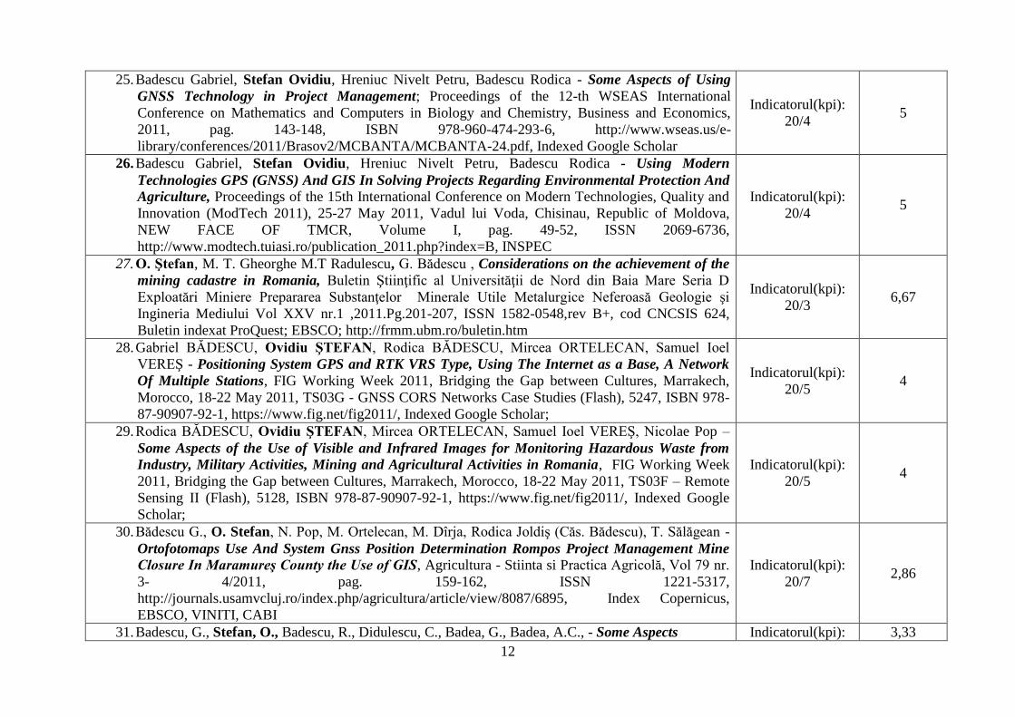
25. Badescu Gabriel, Stefan Ovidiu, Hreniuc Nivelt Petru, Badescu Rodica - Some Aspects of Using
GNSS Technology in Project Management; Proceedings of the 12-th WSEAS International
Conference on Mathematics and Computers in Biology and Chemistry, Business and Economics,
2011, pag. 143-148, ISBN 978-960-474-293-6, http://www.wseas.us/e-
library/conferences/2011/Brasov2/MCBANTA/MCBANTA-24.pdf, Indexed Google Scholar
Indicatorul(kpi):
20/4 5
26. Badescu Gabriel, Stefan Ovidiu, Hreniuc Nivelt Petru, Badescu Rodica - Using Modern
Technologies GPS (GNSS) And GIS In Solving Projects Regarding Environmental Protection And
Agriculture, Proceedings of the 15th International Conference on Modern Technologies, Quality and
Innovation (ModTech 2011), 25-27 May 2011, Vadul lui Voda, Chisinau, Republic of Moldova,
NEW FACE OF TMCR, Volume I, pag. 49-52, ISSN 2069-6736,
http://www.modtech.tuiasi.ro/publication_2011.php?index=B, INSPEC
Indicatorul(kpi):
20/4 5
27. O. Ştefan, M. T. Gheorghe M.T Radulescu, G. Bădescu , Considerations on the achievement of the
mining cadastre in Romania, Buletin Ştiinţific al Universităţii de Nord din Baia Mare Seria D
Exploatări Miniere Prepararea Substanţelor Minerale Utile Metalurgice Neferoasă Geologie şi
Ingineria Mediului Vol XXV nr.1 ,2011.Pg.201-207, ISSN 1582-0548,rev B+, cod CNCSIS 624,
Buletin indexat ProQuest; EBSCO; http://frmm.ubm.ro/buletin.htm
Indicatorul(kpi):
20/3 6,67
28. Gabriel BĂDESCU, Ovidiu ŞTEFAN, Rodica BĂDESCU, Mircea ORTELECAN, Samuel Ioel
VEREŞ - Positioning System GPS and RTK VRS Type, Using The Internet as a Base, A Network
Of Multiple Stations, FIG Working Week 2011, Bridging the Gap between Cultures, Marrakech,
Morocco, 18-22 May 2011, TS03G - GNSS CORS Networks Case Studies (Flash), 5247, ISBN 978-
87-90907-92-1, https://www.fig.net/fig2011/, Indexed Google Scholar;
Indicatorul(kpi):
20/5 4
29. Rodica BĂDESCU, Ovidiu ŞTEFAN, Mircea ORTELECAN, Samuel Ioel VEREŞ, Nicolae Pop –
Some Aspects of the Use of Visible and Infrared Images for Monitoring Hazardous Waste from
Industry, Military Activities, Mining and Agricultural Activities in Romania, FIG Working Week
2011, Bridging the Gap between Cultures, Marrakech, Morocco, 18-22 May 2011, TS03F – Remote
Sensing II (Flash), 5128, ISBN 978-87-90907-92-1, https://www.fig.net/fig2011/, Indexed Google
Scholar;
Indicatorul(kpi):
20/5 4
30. Bădescu G., O. Stefan, N. Pop, M. Ortelecan, M. Dîrja, Rodica Joldiş (Căs. Bădescu), T. Sălăgean -
Ortofotomaps Use And System Gnss Position Determination Rompos Project Management Mine
Closure In Maramureş County the Use of GIS, Agricultura - Stiinta si Practica Agricolă, Vol 79 nr.
3- 4/2011, pag. 159-162, ISSN 1221-5317,
http://journals.usamvcluj.ro/index.php/agricultura/article/view/8087/6895, Index Copernicus,
EBSCO, VINITI, CABI
Indicatorul(kpi):
20/7 2,86
31. Badescu, G., Stefan, O., Badescu, R., Didulescu, C., Badea, G., Badea, A.C., - Some Aspects Indicatorul(kpi): 3,33
13
Regarding the Use of GPS technology of Cheaper Receivers in the Case of Design and Early
Studies for Various Architectural Projects, pag 403-412, Volume of the GeoPreVi International
Symposium, Geodesy Present and Future, 12th-13th of May 2011, Bucharest, Conpress Publishing
House, 2011, ISBN 978-973-100-162-3, ProQuest
20/6
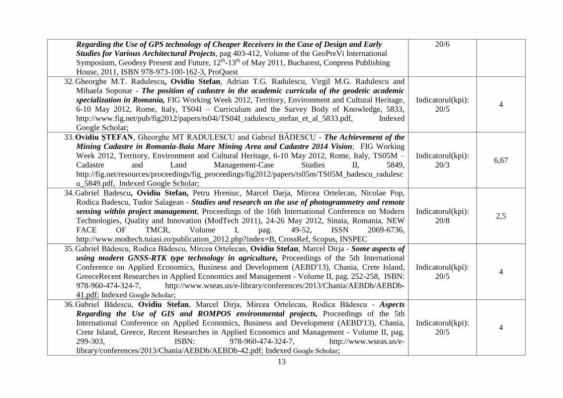
32. Gheorghe M.T. Radulescu, Ovidiu Stefan, Adrian T.G. Radulescu, Virgil M.G. Radulescu and
Mihaela Soponar - The position of cadastre in the academic curricula of the geodetic academic
specialization in Romania, FIG Working Week 2012, Territory, Environment and Cultural Heritage,
6-10 May 2012, Rome, Italy, TS04I – Curriculum and the Survey Body of Knowledge, 5833,
http://www.fig.net/pub/fig2012/papers/ts04i/TS04I_radulescu_stefan_et_al_5833.pdf, Indexed
Google Scholar;
Indicatorul(kpi):
20/5 4
33. Ovidiu ŞTEFAN, Gheorghe MT RADULESCU and Gabriel BĂDESCU - The Achievement of the
Mining Cadastre in Romania-Baia Mare Mining Area and Cadastre 2014 Vision; FIG Working
Week 2012, Territory, Environment and Cultural Heritage, 6-10 May 2012, Rome, Italy, TS05M –
Cadastre and Land Management-Case Studies II, 5849,
http://fig.net/resources/proceedings/fig_proceedings/fig2012/papers/ts05m/TS05M_badescu_radulesc
u_5849.pdf, Indexed Google Scholar;
Indicatorul(kpi):
20/3 6,67
34. Gabriel Badescu, Ovidiu Stefan, Petru Hreniuc, Marcel Darja, Mircea Ortelecan, Nicolae Pop,
Rodica Badescu, Tudor Salagean - Studies and research on the use of photogrammetry and remote
sensing within project management, Proceedings of the 16th International Conference on Modern
Technologies, Quality and Innovation (ModTech 2011), 24-26 May 2012, Sinaia, Romania, NEW
FACE OF TMCR, Volume I, pag. 49-52, ISSN 2069-6736,
http://www.modtech.tuiasi.ro/publication_2012.php?index=B, CrossRef, Scopus, INSPEC
Indicatorul(kpi):
20/8 2,5
35. Gabriel Bădescu, Rodica Bădescu, Mircea Ortelecan, Ovidiu Stefan, Marcel Dirja - Some aspects of
using modern GNSS-RTK type technology in agriculture, Proceedings of the 5th International
Conference on Applied Economics, Business and Development (AEBD'13), Chania, Crete Island,
GreeceRecent Researches in Applied Economics and Management - Volume II, pag. 252-258, ISBN:
978-960-474-324-7, http://www.wseas.us/e-library/conferences/2013/Chania/AEBDb/AEBDb-
41.pdf; Indexed Google Scholar;
Indicatorul(kpi):
20/5 4
36. Gabriel Bădescu, Ovidiu Stefan, Marcel Dirja, Mircea Ortelecan, Rodica Bădescu - Aspects
Regarding the Use of GIS and ROMPOS environmental projects, Proceedings of the 5th
International Conference on Applied Economics, Business and Development (AEBD'13), Chania,
Crete Island, Greece, Recent Researches in Applied Economics and Management - Volume II, pag.
299-303, ISBN: 978-960-474-324-7, http://www.wseas.us/e-
library/conferences/2013/Chania/AEBDb/AEBDb-42.pdf; Indexed Google Scholar;
Indicatorul(kpi):
20/5 4
14
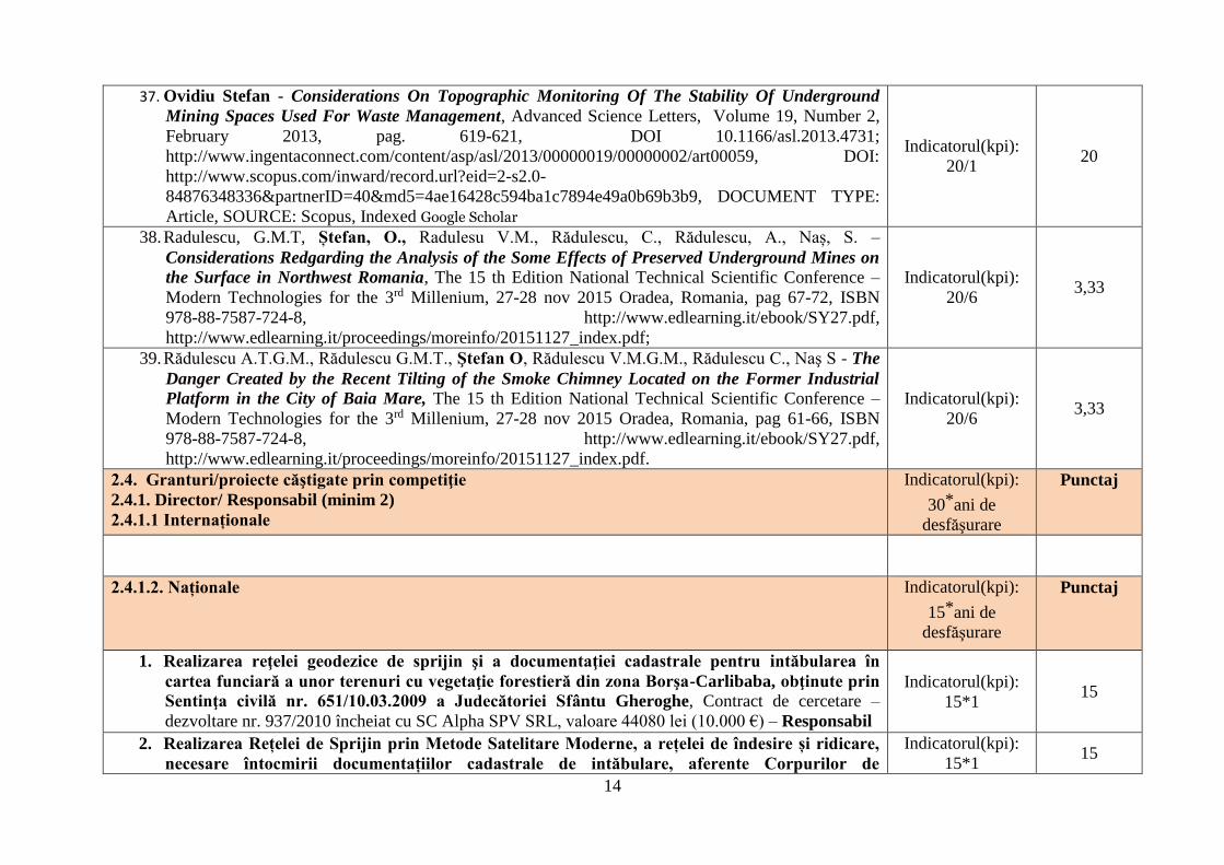
37. Ovidiu Stefan - Considerations On Topographic Monitoring Of The Stability Of Underground
Mining Spaces Used For Waste Management, Advanced Science Letters, Volume 19, Number 2,
February 2013, pag. 619-621, DOI 10.1166/asl.2013.4731;
http://www.ingentaconnect.com/content/asp/asl/2013/00000019/00000002/art00059, DOI:
http://www.scopus.com/inward/record.url?eid=2-s2.0-
84876348336&partnerID=40&md5=4ae16428c594ba1c7894e49a0b69b3b9, DOCUMENT TYPE:
Article, SOURCE: Scopus, Indexed Google Scholar
Indicatorul(kpi):
20/1 20
38. Radulescu, G.M.T, Ștefan, O., Radulesu V.M., Rădulescu, C., Rădulescu, A., Naș, S. –
Considerations Redgarding the Analysis of the Some Effects of Preserved Underground Mines on
the Surface in Northwest Romania, The 15 th Edition National Technical Scientific Conference –
Modern Technologies for the 3rd Millenium, 27-28 nov 2015 Oradea, Romania, pag 67-72, ISBN
978-88-7587-724-8, http://www.edlearning.it/ebook/SY27.pdf,
http://www.edlearning.it/proceedings/moreinfo/20151127_index.pdf;
Indicatorul(kpi):
20/6 3,33
39. Rădulescu A.T.G.M., Rădulescu G.M.T., Ştefan O, Rădulescu V.M.G.M., Rădulescu C., Naş S - The
Danger Created by the Recent Tilting of the Smoke Chimney Located on the Former Industrial
Platform in the City of Baia Mare, The 15 th Edition National Technical Scientific Conference –
Modern Technologies for the 3rd Millenium, 27-28 nov 2015 Oradea, Romania, pag 61-66, ISBN
978-88-7587-724-8, http://www.edlearning.it/ebook/SY27.pdf,
http://www.edlearning.it/proceedings/moreinfo/20151127_index.pdf.
Indicatorul(kpi):
20/6 3,33
2.4. Granturi/proiecte căştigate prin competiţie
2.4.1. Director/ Responsabil (minim 2)
2.4.1.1 Internaționale
Indicatorul(kpi):
30*ani de
desfăşurare
Punctaj
2.4.1.2. Naționale Indicatorul(kpi):
15*ani de
desfăşurare
Punctaj
1. Realizarea reţelei geodezice de sprijin şi a documentaţiei cadastrale pentru intăbularea în
cartea funciară a unor terenuri cu vegetaţie forestieră din zona Borşa-Carlibaba, obţinute prin
Sentinţa civilă nr. 651/10.03.2009 a Judecătoriei Sfântu Gheroghe, Contract de cercetare –
dezvoltare nr. 937/2010 încheiat cu SC Alpha SPV SRL, valoare 44080 lei (10.000 €) – Responsabil
Indicatorul(kpi):
15*1 15
2. Realizarea Rețelei de Sprijin prin Metode Satelitare Moderne, a rețelei de îndesire și ridicare,
necesare întocmirii documentațiilor cadastrale de intăbulare, aferente Corpurilor de
Indicatorul(kpi):
15*1 15
15
proprietate din suprafața Administrativ Teritorială a Comunei Feldru, Județul Bistrița
Năsăud, Contract de cercetare – dezvoltare nr. 2877/22.12.2009 (1036/2009), Ocolul Silvic Feldru,
valoare 50400 lei – Responsabil
3. Lucrări topografice şi cadastrale aferente întocmirii documentaţiei cadastrale necesare
înscrierii în cartea funciară a dreptului de proprietate asupra terenului pe care se află edificat
„Centrul Social Necesar” şi Centrala Termică nr. 41. Contract de cercetare – dezvoltare nr.
625/2007 (3285/2007), contractant Serviciul Public de Asistenţă Socială Baia Mare - Responsabil
Indicatorul(kpi):
15*1 15
4. Lucrări topografice şi cadastrale aferente terenului de sub Monumentul Eroilor şi a locaţiei
viitoarei Primării din Cerneşti. Contract de cercetare – dezvoltare nr. 624/2007 (1102/2007),
contractant Consiliul Local Cerneşti, - Responsabil
Indicatorul(kpi):
15*1 15
5. Realizarea rețelei de sprijin prin metode satelitare, aferentă corpurilor de proprietate din
Ocolul Silvic Lipova, U.P.V. BELOTINT Județul ARAD, Contract de cercetare – dezvoltare nr.
337/2009 (5/2009), contractant SC CADASTRU PROIECT SRL Arad – Responsabil
Indicatorul(kpi):
15*1 15
6. Realizarea rețelei de sprijin prin metode satelitare, aferentă corpurilor de proprietate din
Localitatea Bocsig, Composesoratul Foștilor Urbarialiști Bocsig, Județul ARAD, Contract de
cercetare – dezvoltare nr. 708/2009 (11/2009) contractant SC TOPO MONDO WEST SRL ARAD -
Responsabil
Indicatorul(kpi):
15*1 15
7. Studii și cercetări privind utilizarea Sistemului GNSS la optimizarea Rețelei Geodezice de
Îndesire, a orașului Negrești-Oaș, Județul Satu Mare, Contract de cercetare – dezvoltare nr.
2053/2009 (578/2009), contractant SC GEODEZ TOPO SRL Negrești Oaș - Responsabil
Indicatorul(kpi):
15*1 15
8. Studii privind realizarea Rețelei de Sprijin prin metode satelitare, aferente Localitătilor Livada
și Sinleani, Județul ARAD, Contract de cercetare – dezvoltare nr. 708/2009 (27/2009), contractant
SC DENTAL TOPO SRL Arad - Responsabil
Indicatorul(kpi):
15*1 15
9. Modelarea cartografică a localității Codlea, Contract de cercetare – dezvoltare nr. 95/2009
(2/2009), încheiat cu SC Geodata System SRL Brașov – Responsabil
Indicatorul(kpi):
15*1 15
10. Studii privind realizarea Rețelei de Sprijin, de îndesire și de ridicare prin metode satelitare,
necesare realizării planurilor parcelare din comuna Racșa, județul Satu Mare, Contract de
cercetare – dezvoltare nr. 3547/2012 (37/2012), încheiat cu SC Diferit Building SRL – Responsabil
Indicatorul(kpi):
15*1 15
11. Studii privind realizarea Rețelei de Sprijin, de îndesire și de ridicare prin metode satelitare,
necesare realizării rețelei de alimentare cu apă și canalizare din comuna Racșa, județul Satu
Mare, Contract de cercetare – dezvoltare nr. 3543/2012 (38/2012), încheiat cu SC Diferit Building
SRL – Responsabil
Indicatorul(kpi):
15*1 15
2.4.2. Membru în echipă Indicatorul(kpi): Punctaj
16
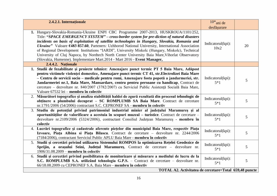
2.4.2.1. Internaționale 10*ani de
desfăşurare
1. Hungary-Slovakia-Romania-Ukraine ENPI CBC Programme 2007-2013, HUSKROUA/1101/252,
Title: “SPACE EMERGENCY SYSTEM” – cross-border system for pre-diction of natural disasters
incidents on basis of exploitation of satellite technologies in Hungary, Slovakia, Romania and
Ukraine” Valoare €483 857.60, Parteners: Uzhhorod National University, International Association
of Regional Development Institutions “IARDI”, University Miskolc (Hungary, Miskolc), Technical
University of Cluj Napoca, by Nordtech North Center University Baia Mare,Vihorlat Observatory
(Slovakia, Humenne). Implementare Mart.2014 - Mart 2016 - Event Manager,
Indicatorul(kpi):
10x2 20
2.4.4.2. Naționale
1. Studii de fezabilitate și proiecte tehnice: Amenajare punct termic PT 5 Baia Mare, Adăpost
pentru victimele violenţei domestice, Amenajare punct termic CT 41, str.Electrolizei Baia Mare
– Centru de servicii socio – medicale pentru romi, Amenajare fosta popotă a jandarmeriei, str.
Jandarmeriei nr.1, Baia Mare, Mansardare, centru pentru persoane cu handicap, Contract de
cercetare – dezvoltare nr. 840/2007 (3782/2007) cu Serviciul Public Asistenţă Socială Baia Mare,
Valoare 67532 lei – membru în colectiv
Indicatorul(kpi):
5*1 5
2. Măsurători topografice şi analiza stabilităţii haldei de zgură rezultată din procesul tehnologic de
obţinere a plumbului decuprat – SC ROMPLUMB SA Baia Mare. Contract de cercetare
nr.1791/2006 (54/2006) contractant S.C. CEPRONEF SA - membru în colectiv
Indicatorul(kpi):
5*1 5
3. Studiu de potenţial privind patrimoniul industrial minier al judeţului Maramureş şi al
oportunităţilor de valorificare a acestuia în scopuri muzeal – turistice. Contract de cercetare –
dezvoltare nr.2109/2006 (5324/2006), contractant Consiliul Judeţean Maramureş - membru în
colectiv
Indicatorul(kpi):
5*1 5
4. Lucrări topografice şi cadastrale aferente pieţelor din municipiul Baia Mare, respectiv Piaţa
Izvoare, Piaţa Albina si Piaţa Bilascu. Contract de cercetare – dezvoltare nr. 2244/2006
(7184/2006), contractant Serviciul Public APLU Baia Mare - membru în colectiv
Indicatorul(kpi):
5*1 5
5. Studii și cercetări privind utilizarea Sistemului ROMPOS la optimizarea Rețelei Geodezice de
Sprijin, a orașului Seini, Județul Maramureș, Contract de cercetare – dezvoltare nr.
1906/31.08.2009 – membru în colectiv
Indicatorul(kpi):
5*1 5
6. Studii și cercetări privind posibilitatea de monitorizare și măsurare a mediului de lucru de la
S.C. ROMPLUMB S.A. utilizând tehnologia G.P.S. – Contract de cercetare – dezvoltare nr.
66/18.08.2009 cu CEPRONEF S.A. Baia Mare - membru în colectiv
Indicatorul(kpi):
5*1 5
TOTAL A2. Activitatea de cercetare=Total 659,48 puncte
17
A3. Recunoaştere şi impactul activităţii
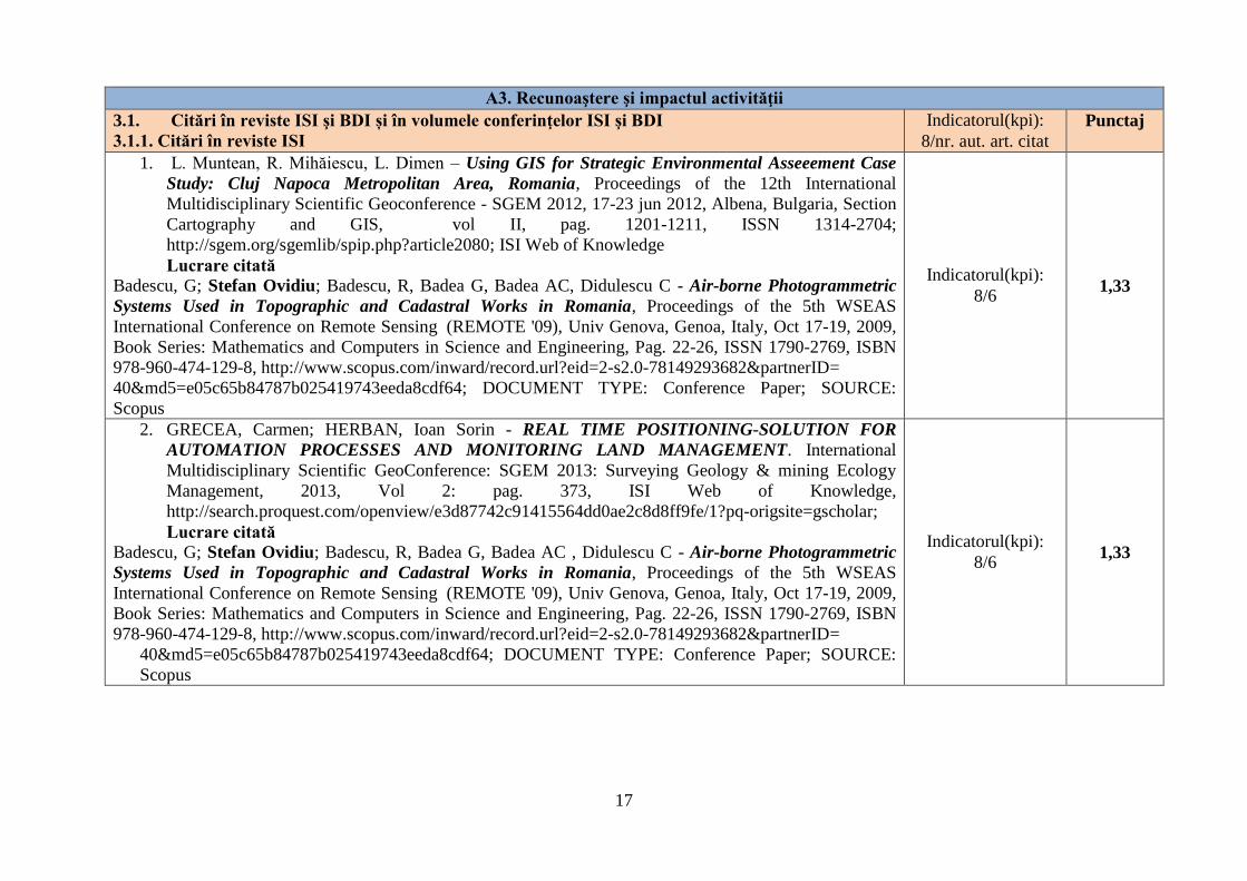
3.1. Citări în reviste ISI şi BDI și în volumele conferinţelor ISI şi BDI
3.1.1. Citări în reviste ISI
Indicatorul(kpi):
8/nr. aut. art. citat
Punctaj
1. L. Muntean, R. Mihăiescu, L. Dimen – Using GIS for Strategic Environmental Asseeement Case
Study: Cluj Napoca Metropolitan Area, Romania, Proceedings of the 12th International
Multidisciplinary Scientific Geoconference - SGEM 2012, 17-23 jun 2012, Albena, Bulgaria, Section
Cartography and GIS, vol II, pag. 1201-1211, ISSN 1314-2704;
http://sgem.org/sgemlib/spip.php?article2080; ISI Web of Knowledge
Lucrare citată
Badescu, G; Stefan Ovidiu; Badescu, R, Badea G, Badea AC, Didulescu C - Air-borne Photogrammetric
Systems Used in Topographic and Cadastral Works in Romania, Proceedings of the 5th WSEAS
International Conference on Remote Sensing (REMOTE '09), Univ Genova, Genoa, Italy, Oct 17-19, 2009,
Book Series: Mathematics and Computers in Science and Engineering, Pag. 22-26, ISSN 1790-2769, ISBN
978-960-474-129-8, http://www.scopus.com/inward/record.url?eid=2-s2.0-78149293682&partnerID=
40&md5=e05c65b84787b025419743eeda8cdf64; DOCUMENT TYPE: Conference Paper; SOURCE:
Scopus
Indicatorul(kpi):
8/6 1,33
2. GRECEA, Carmen; HERBAN, Ioan Sorin - REAL TIME POSITIONING-SOLUTION FOR
AUTOMATION PROCESSES AND MONITORING LAND MANAGEMENT. International
Multidisciplinary Scientific GeoConference: SGEM 2013: Surveying Geology & mining Ecology
Management, 2013, Vol 2: pag. 373, ISI Web of Knowledge,
http://search.proquest.com/openview/e3d87742c91415564dd0ae2c8d8ff9fe/1?pq-origsite=gscholar;
Lucrare citată
Badescu, G; Stefan Ovidiu; Badescu, R, Badea G, Badea AC , Didulescu C - Air-borne Photogrammetric
Systems Used in Topographic and Cadastral Works in Romania, Proceedings of the 5th WSEAS
International Conference on Remote Sensing (REMOTE '09), Univ Genova, Genoa, Italy, Oct 17-19, 2009,
Book Series: Mathematics and Computers in Science and Engineering, Pag. 22-26, ISSN 1790-2769, ISBN
978-960-474-129-8, http://www.scopus.com/inward/record.url?eid=2-s2.0-78149293682&partnerID=
40&md5=e05c65b84787b025419743eeda8cdf64; DOCUMENT TYPE: Conference Paper; SOURCE:
Scopus
Indicatorul(kpi):
8/6 1,33
18
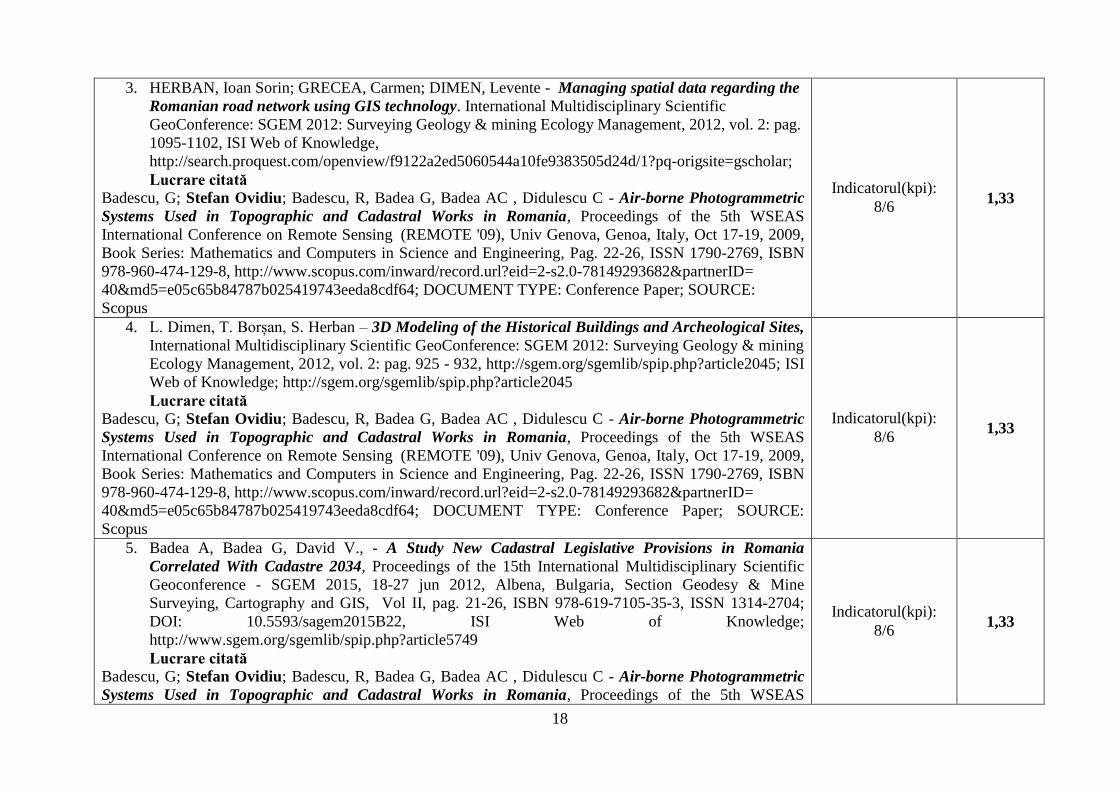
3. HERBAN, Ioan Sorin; GRECEA, Carmen; DIMEN, Levente - Managing spatial data regarding the
Romanian road network using GIS technology. International Multidisciplinary Scientific
GeoConference: SGEM 2012: Surveying Geology & mining Ecology Management, 2012, vol. 2: pag.
1095-1102, ISI Web of Knowledge,
http://search.proquest.com/openview/f9122a2ed5060544a10fe9383505d24d/1?pq-origsite=gscholar;
Lucrare citată
Badescu, G; Stefan Ovidiu; Badescu, R, Badea G, Badea AC , Didulescu C - Air-borne Photogrammetric
Systems Used in Topographic and Cadastral Works in Romania, Proceedings of the 5th WSEAS
International Conference on Remote Sensing (REMOTE '09), Univ Genova, Genoa, Italy, Oct 17-19, 2009,
Book Series: Mathematics and Computers in Science and Engineering, Pag. 22-26, ISSN 1790-2769, ISBN
978-960-474-129-8, http://www.scopus.com/inward/record.url?eid=2-s2.0-78149293682&partnerID=
40&md5=e05c65b84787b025419743eeda8cdf64; DOCUMENT TYPE: Conference Paper; SOURCE:
Scopus
Indicatorul(kpi):
8/6 1,33
4. L. Dimen, T. Borșan, S. Herban – 3D Modeling of the Historical Buildings and Archeological Sites,
International Multidisciplinary Scientific GeoConference: SGEM 2012: Surveying Geology & mining
Ecology Management, 2012, vol. 2: pag. 925 - 932, http://sgem.org/sgemlib/spip.php?article2045; ISI
Web of Knowledge; http://sgem.org/sgemlib/spip.php?article2045
Lucrare citată
Badescu, G; Stefan Ovidiu; Badescu, R, Badea G, Badea AC , Didulescu C - Air-borne Photogrammetric
Systems Used in Topographic and Cadastral Works in Romania, Proceedings of the 5th WSEAS
International Conference on Remote Sensing (REMOTE '09), Univ Genova, Genoa, Italy, Oct 17-19, 2009,
Book Series: Mathematics and Computers in Science and Engineering, Pag. 22-26, ISSN 1790-2769, ISBN
978-960-474-129-8, http://www.scopus.com/inward/record.url?eid=2-s2.0-78149293682&partnerID=
40&md5=e05c65b84787b025419743eeda8cdf64; DOCUMENT TYPE: Conference Paper; SOURCE:
Scopus
Indicatorul(kpi):
8/6 1,33
5. Badea A, Badea G, David V., - A Study New Cadastral Legislative Provisions in Romania
Correlated With Cadastre 2034, Proceedings of the 15th International Multidisciplinary Scientific
Geoconference - SGEM 2015, 18-27 jun 2012, Albena, Bulgaria, Section Geodesy & Mine
Surveying, Cartography and GIS, Vol II, pag. 21-26, ISBN 978-619-7105-35-3, ISSN 1314-2704;
DOI: 10.5593/sagem2015B22, ISI Web of Knowledge;
http://www.sgem.org/sgemlib/spip.php?article5749
Lucrare citată
Badescu, G; Stefan Ovidiu; Badescu, R, Badea G, Badea AC , Didulescu C - Air-borne Photogrammetric
Systems Used in Topographic and Cadastral Works in Romania, Proceedings of the 5th WSEAS
Indicatorul(kpi):
8/6 1,33
19
International Conference on Remote Sensing (REMOTE '09), Univ Genova, Genoa, Italy, Oct 17-19, 2009,
Book Series: Mathematics and Computers in Science and Engineering, Pag. 22-26, ISSN 1790-2769, ISBN
978-960-474-129-8, http://www.scopus.com/inward/record.url?eid=2-s2.0-78149293682&partnerID=
40&md5=e05c65b84787b025419743eeda8cdf64; DOCUMENT TYPE: Conference Paper; SOURCE:
Scopus
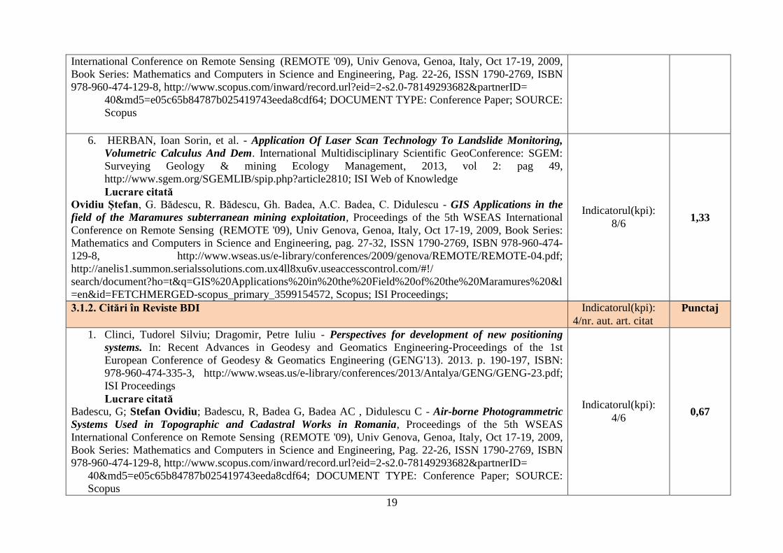
6. HERBAN, Ioan Sorin, et al. - Application Of Laser Scan Technology To Landslide Monitoring,
Volumetric Calculus And Dem. International Multidisciplinary Scientific GeoConference: SGEM:
Surveying Geology & mining Ecology Management, 2013, vol 2: pag 49,
http://www.sgem.org/SGEMLIB/spip.php?article2810; ISI Web of Knowledge
Lucrare citată
Ovidiu Ştefan, G. Bădescu, R. Bădescu, Gh. Badea, A.C. Badea, C. Didulescu - GIS Applications in the
field of the Maramures subterranean mining exploitation, Proceedings of the 5th WSEAS International
Conference on Remote Sensing (REMOTE '09), Univ Genova, Genoa, Italy, Oct 17-19, 2009, Book Series:
Mathematics and Computers in Science and Engineering, pag. 27-32, ISSN 1790-2769, ISBN 978-960-474-
129-8, http://www.wseas.us/e-library/conferences/2009/genova/REMOTE/REMOTE-04.pdf;
http://anelis1.summon.serialssolutions.com.ux4ll8xu6v.useaccesscontrol.com/#!/
search/document?ho=t&q=GIS%20Applications%20in%20the%20Field%20of%20the%20Maramures%20&l
=en&id=FETCHMERGED-scopus_primary_3599154572, Scopus; ISI Proceedings;
Indicatorul(kpi):
8/6 1,33
3.1.2. Citări în Reviste BDI Indicatorul(kpi):
4/nr. aut. art. citat
Punctaj
1. Clinci, Tudorel Silviu; Dragomir, Petre Iuliu - Perspectives for development of new positioning
systems. In: Recent Advances in Geodesy and Geomatics Engineering-Proceedings of the 1st
European Conference of Geodesy & Geomatics Engineering (GENG'13). 2013. p. 190-197, ISBN:
978-960-474-335-3, http://www.wseas.us/e-library/conferences/2013/Antalya/GENG/GENG-23.pdf;
ISI Proceedings
Lucrare citată
Badescu, G; Stefan Ovidiu; Badescu, R, Badea G, Badea AC , Didulescu C - Air-borne Photogrammetric
Systems Used in Topographic and Cadastral Works in Romania, Proceedings of the 5th WSEAS
International Conference on Remote Sensing (REMOTE '09), Univ Genova, Genoa, Italy, Oct 17-19, 2009,
Book Series: Mathematics and Computers in Science and Engineering, Pag. 22-26, ISSN 1790-2769, ISBN
978-960-474-129-8, http://www.scopus.com/inward/record.url?eid=2-s2.0-78149293682&partnerID=
40&md5=e05c65b84787b025419743eeda8cdf64; DOCUMENT TYPE: Conference Paper; SOURCE:
Scopus
Indicatorul(kpi):
4/6 0,67
20
2. BADEA, Ana-Cornelıa; BADEA, Gheorghe - Specific Issues in Green Resource Management in
Romania, TS 8.2 - GIS & Planning Implementations, WCS-CE - The World Cadastre Summit,
Congress & Exhibition Istanbul, Turkey, 20 –25 April 2015,
http://wcadastre.org/files/fulltexts/fulltext93.pdf;
Lucrare citată
Badescu, G; Stefan Ovidiu; Badescu, R, Badea G, Badea AC , Didulescu C - Air-borne Photogrammetric
Systems Used in Topographic and Cadastral Works in Romania, Proceedings of the 5th WSEAS
International Conference on Remote Sensing (REMOTE '09), Univ Genova, Genoa, Italy, Oct 17-19, 2009,
Book Series: Mathematics and Computers in Science and Engineering, Pag. 22-26, ISSN 1790-2769, ISBN
978-960-474-129-8, http://www.scopus.com/inward/record.url?eid=2-s2.0-78149293682&partnerID=
40&md5=e05c65b84787b025419743eeda8cdf64; DOCUMENT TYPE: Conference Paper; SOURCE:
Scopus
Indicatorul(kpi):
4/6 0,67
3. Didulescu C, Savu A, Badea Gh, Badea A - Using 3D terrestrial laser scanning technology to obtain
3D deliverables, CAIUS, Didulescu, et al. Using 3D Terrestrial Laser Scanning Technology to Obtain
3D Deliverables. Advanced Science Letters, 2013, 19.1: pag. 70-74,
http://www.ingentaconnect.com/content/asp/asl/2013/00000019/00000001/art00014;
Lucrare citată
Badescu, G; Stefan Ovidiu; Badescu, R, Badea G, Badea AC , Didulescu C - Air-borne Photogrammetric
Systems Used in Topographic and Cadastral Works in Romania, Proceedings of the 5th WSEAS
International Conference on Remote Sensing (REMOTE '09), Univ Genova, Genoa, Italy, Oct 17-19, 2009,
Book Series: Mathematics and Computers in Science and Engineering, Pag. 22-26, ISSN 1790-2769, ISBN
978-960-474-129-8, http://www.scopus.com/inward/record.url?eid=2-s2.0-78149293682&partnerID=
40&md5=e05c65b84787b025419743eeda8cdf64; DOCUMENT TYPE: Conference Paper; SOURCE:
Scopus
Indicatorul(kpi):
4/6 0,67
4. Badescu G., M. Dirja, M. Ortelecan , Ana Ciotlaus, N. Pop, Rodica Badescu, T. Salagean , Adela
Hoble - THE USE OF GIS TECHNOLOGY AND ROMPOS IN ACQUIRING DATA ON
ENVIRONMENTAL PROTECTION PROJECTS, Agricultura – Ştiinţă şi practică, nr. 3- 4(83-
84)/2012, pag 146-152, http://journals.usamvcluj.ro/index.php/agricultura/article/view/9081/7737
Lucrare citată
Badescu, G; Stefan Ovidiu; Badescu, R, Badea G, Badea AC , Didulescu C - Air-borne Photogrammetric
Systems Used in Topographic and Cadastral Works in Romania, Proceedings of the 5th WSEAS
International Conference on Remote Sensing (REMOTE '09), Univ Genova, Genoa, Italy, Oct 17-19, 2009,
Book Series: Mathematics and Computers in Science and Engineering, Pag. 22-26, ISSN 1790-2769, ISBN
978-960-474-129-8, http://www.scopus.com/inward/record.url?eid=2-s2.0-78149293682&partnerID=
Indicatorul(kpi):
4/6 0,67
21
40&md5=e05c65b84787b025419743eeda8cdf64; DOCUMENT TYPE: Conference Paper; SOURCE:
Scopus
5. Muşat Cosmin Constantin, Vîlceanu Clara Beatrice, Moscovici Anca Maria - Systematic registration
of properties – a new challenge for Romanian cadastral system, Journal of Geodesy,
Cartography and Cadastre, Revista de Geodezie, Cartografie și Cadastru/ UGR, Received: April
2015 / Accepted: September 2015 / Published: December 2015, pag 15-20,
http://www.ugr2014.ro/upload/pagefiles/file/Rev%203.pdf#page=15
Lucrare citată
Badescu, G; Stefan Ovidiu; Badescu, R, Badea G, Badea AC , Didulescu C - Air-borne Photogrammetric
Systems Used in Topographic and Cadastral Works in Romania, Proceedings of the 5th WSEAS
International Conference on Remote Sensing (REMOTE '09), Univ Genova, Genoa, Italy, Oct 17-19, 2009,
Book Series: Mathematics and Computers in Science and Engineering, Pag. 22-26, ISSN 1790-2769, ISBN
978-960-474-129-8, http://www.scopus.com/inward/record.url?eid=2-s2.0-78149293682&partnerID=
40&md5=e05c65b84787b025419743eeda8cdf64; DOCUMENT TYPE: Conference Paper; SOURCE:
Scopus
Indicatorul(kpi):
4/6 0,67
6. BADEA, GHEORGHE - Software Possibilities for 3D Representations—Urban Management
Using 3D Models. Recent Advances in Geodesy and Geomatics Engineering, 2013, pag. 247-254,
http://www.wseas.us/e-library/conferences/2013/Antalya/GENG/GENG-31.pdf;
Lucrare citată
Ovidiu Ştefan, G. Bădescu, R. Bădescu, Gh. Badea, A.C. Badea, C. Didulescu - GIS Applications in the
field of the Maramures subterranean mining exploitation, Proceedings of the 5th WSEAS International
Conference on Remote Sensing (REMOTE '09), Univ Genova, Genoa, Italy, Oct 17-19, 2009, Book Series:
Mathematics and Computers in Science and Engineering, pag. 27-32, ISSN 1790-2769, ISBN 978-960-474-
129-8, http://www.wseas.us/e-library/conferences/2009/genova/REMOTE/REMOTE-04.pdf;
http://anelis1.summon.serialssolutions.com.ux4ll8xu6v.useaccesscontrol.com/#!/
search/document?ho=t&q=GIS%20Applications%20in%20the%20Field%20of%20the%20Maramures%20&l
=en&id=FETCHMERGED-scopus_primary_3599154572, Scopus; ISI Proceedings;
Indicatorul(kpi):
4/6
0,67
7. Ana-Cornelia Badea - Geostatistical Models Used in GIS for Geomorphological Processes,
International Journal of Geology, Vol 8, 2014, pag. 1-8; ISSN: 1998-4499;
http://www.naun.org/main/NAUN/geology/2014/a022014-143.pdf
Lucrare citată
Ovidiu Ştefan, G. Bădescu, R. Bădescu, Gh. Badea, A.C. Badea, C. Didulescu - GIS Applications in the
field of the Maramures subterranean mining exploitation, Proceedings of the 5th WSEAS International
Indicatorul(kpi):
4/6
0,67
22
Conference on Remote Sensing (REMOTE '09), Univ Genova, Genoa, Italy, Oct 17-19, 2009, Book Series:
Mathematics and Computers in Science and Engineering, pag. 27-32, ISSN 1790-2769, ISBN 978-960-474-
129-8, http://www.wseas.us/e-library/conferences/2009/genova/REMOTE/REMOTE-04.pdf;
http://anelis1.summon.serialssolutions.com.ux4ll8xu6v.useaccesscontrol.com/#!/
search/document?ho=t&q=GIS%20Applications%20in%20the%20Field%20of%20the%20Maramure
s%20&l=en&id=FETCHMERGED-scopus_primary_3599154572, Scopus; ISI Proceedings;
8. Ana-Cornelia Badea - Parcel Fabric – A Good Possibility for Management of Geospatial Cadastral
Data, International Journal Of Systems Applications, Engineering & Development, Vol 8, 2014, pag.
47-53, ISSN 2074-1308; http://www.naun.org/main/UPress/saed/2014/a142014-144.pdf
Lucrare citată
Ovidiu Ştefan, G. Bădescu, R. Bădescu, Gh. Badea, A.C. Badea, C. Didulescu - GIS Applications in the
field of the Maramures subterranean mining exploitation, Proceedings of the 5th WSEAS International
Conference on Remote Sensing (REMOTE '09), Univ Genova, Genoa, Italy, Oct 17-19, 2009, Book Series:
Mathematics and Computers in Science and Engineering, pag. 27-32, ISSN 1790-2769, ISBN 978-960-474-
129-8, http://www.wseas.us/e-library/conferences/2009/genova/REMOTE/REMOTE-04.pdf;
http://anelis1.summon.serialssolutions.com.ux4ll8xu6v.useaccesscontrol.com/#!/
search/document?ho=t&q=GIS%20Applications%20in%20the%20Field%20of%20the%20Maramure
s%20&l=en&id=FETCHMERGED-scopus_primary_3599154572, Scopus; ISI Proceedings;
Indicatorul(kpi):
4/6
0,67
9. BADEA, GHEORGHE - Importance of 3D Modeling Software in Urban Environment,
International Journal Of Systems Applications, Engineering & Development, Vol 8, 2014, pag. 100-
107, ISSN 2074-1308; http://www.naun.org/main/UPress/saed/2014/a262014-146.pdf
Lucrare citată
Ovidiu Ştefan, G. Bădescu, R. Bădescu, Gh. Badea, A.C. Badea, C. Didulescu - GIS Applications in the
field of the Maramures subterranean mining exploitation, Proceedings of the 5th WSEAS International
Conference on Remote Sensing (REMOTE '09), Univ Genova, Genoa, Italy, Oct 17-19, 2009, Book Series:
Mathematics and Computers in Science and Engineering, pag. 27-32, ISSN 1790-2769, ISBN 978-960-474-
129-8, http://www.wseas.us/e-library/conferences/2009/genova/REMOTE/REMOTE-04.pdf;
http://anelis1.summon.serialssolutions.com.ux4ll8xu6v.useaccesscontrol.com/#!/
search/document?ho=t&q=GIS%20Applications%20in%20the%20Field%20of%20the%20Maramure
s%20&l=en&id=FETCHMERGED-scopus_primary_3599154572, Scopus; ISI Proceedings;
Indicatorul(kpi):
4/6
0,67
10. BADEA, Ana-Cornelıa; BADEA, Gheorghe - Specific Issues in Green Resource Management in
Romania, TS 8.2 - GIS & Planning Implementations, WCS-CE - The World Cadastre Summit,
Congress & Exhibition Istanbul, Turkey, 20 –25 April 2015,
http://wcadastre.org/files/fulltexts/fulltext93.pdf;
Indicatorul(kpi):
4/6
0,67

23
Lucrare citată
Ovidiu Ştefan, G. Bădescu, R. Bădescu, Gh. Badea, A.C. Badea, C. Didulescu - GIS Applications in the
field of the Maramures subterranean mining exploitation, Proceedings of the 5th WSEAS International
Conference on Remote Sensing (REMOTE '09), Univ Genova, Genoa, Italy, Oct 17-19, 2009, Book Series:
Mathematics and Computers in Science and Engineering, pag. 27-32, ISSN 1790-2769, ISBN 978-960-474-
129-8, http://www.wseas.us/e-library/conferences/2009/genova/REMOTE/REMOTE-04.pdf;
http://anelis1.summon.serialssolutions.com.ux4ll8xu6v.useaccesscontrol.com/#!/
search/document?ho=t&q=GIS%20Applications%20in%20the%20Field%20of%20the%20Maramure
s%20&l=en&id=FETCHMERGED-scopus_primary_3599154572, Scopus; ISI Proceedings;
11. Badescu G., M. Dirja, M. Ortelecan , Ana Ciotlaus, N. Pop, Rodica Badescu, T. Salagean , Adela
Hoble - THE USE OF GIS TECHNOLOGY AND ROMPOS IN ACQUIRING DATA ON
ENVIRONMENTAL PROTECTION PROJECTS, Agricultura – Ştiinţă şi practică, nr. 3- 4(83-
84)/2012, pag 146-152,
http://journals.usamvcluj.ro/index.php/agricultura/article/view/9081/7737
Lucrare citată
Ovidiu Ştefan, G. Bădescu, R. Bădescu, Gh. Badea, A.C. Badea, C. Didulescu - GIS Applications in the
field of the Maramures subterranean mining exploitation, Proceedings of the 5th WSEAS International
Conference on Remote Sensing (REMOTE '09), Univ Genova, Genoa, Italy, Oct 17-19, 2009, Book Series:
Mathematics and Computers in Science and Engineering, pag. 27-32, ISSN 1790-2769, ISBN 978-960-474-
129-8, http://www.wseas.us/e-library/conferences/2009/genova/REMOTE/REMOTE-04.pdf;
http://anelis1.summon.serialssolutions.com.ux4ll8xu6v.useaccesscontrol.com/#!/
search/document?ho=t&q=GIS%20Applications%20in%20the%20Field%20of%20the%20Maramure
s%20&l=en&id=FETCHMERGED-scopus_primary_3599154572, Scopus; ISI Proceedings;
Indicatorul(kpi):
4/6
0,67
12. Didulescu C, Savu A, Badea Gh, Badea A - Using 3D terrestrial laser scanning technology to obtain
3D deliverables, CAIUS, Didulescu, et al. Using 3D Terrestrial Laser Scanning Technology to Obtain
3D Deliverables. Advanced Science Letters, 2013, 19.1: pag. 70-74,
http://www.ingentaconnect.com/content/asp/asl/2013/00000019/00000001/art00014;
Lucrare citată
Badescu, G; Stefan Ovidiu; Radulescu, GM - Using Satellite Methods, GNSS ROMPOS in Developing the
Control and Survey Network of LIPOVA Forestry Buildings, UPV BELOTINT, ARAD County, Proceedings of the 2nd WSEAS International Conference on Engineering Mechanics, Structures and
Engineering Geology (EMESEG '09), Rhodes GREECE, 22-24 Jul. 2009, Book Series: Mathematics and
Computers in Science and Engineering, Pag. 262-267, http://www.scopus.com/inward/record.url?eid=2-s2.0-
74549172550&partnerID=40&md5=caefb26740ae2b336c56214f6a4bf2ca; DOCUMENT TYPE: Conference
Indicatorul(kpi):
4/3 1,33
24
Paper; SOURCE: Scopus; ISI Proceedings
13. Caius Didulescu - Some aspects of making landslide hazard map in Romania. Recent Advances in
Geodesy and Geomatics Engineering , ISBN: 978-960-474-335-3, http://www.wseas.us/e-
library/conferences/2013/Antalya/GENG/GENG-16.pdf;
Lucrare citată
Badescu, G; Stefan Ovidiu; Radulescu, GM - Using Satellite Methods, GNSS ROMPOS in Developing the
Control and Survey Network of LIPOVA Forestry Buildings, UPV BELOTINT, ARAD County, Proceedings of the 2nd WSEAS International Conference on Engineering Mechanics, Structures and
Engineering Geology (EMESEG '09), Rhodes GREECE, 22-24 Jul. 2009, Book Series: Mathematics and
Computers in Science and Engineering, Pag. 262-267, http://www.scopus.com/inward/record.url?eid=2-s2.0-
74549172550&partnerID=40&md5=caefb26740ae2b336c56214f6a4bf2ca; DOCUMENT TYPE: Conference
Paper; SOURCE: Scopus; ISI Proceedings
Indicatorul(kpi):
4/3 1,33
14. Joldis (Badescu) Rodica, M. Dirja, G. Badescu, Adela Hoble - OROGRAPHY ANALYSIS BY
COMPLEX PATTERNS OF SPATIAL ANALYSIS, Agriculture - Science and Practice, no. 1- 2(89-
90)/2014, pag 173-179, http://journals.usamvcluj.ro/index.php/agricultura/article/view/10251
Lucrare citată
Badescu, G; Stefan Ovidiu; Radulescu, GM - Using Satellite Methods, GNSS ROMPOS in Developing the
Control and Survey Network of LIPOVA Forestry Buildings, UPV BELOTINT, ARAD County, Proceedings of the 2nd WSEAS International Conference on Engineering Mechanics, Structures and
Engineering Geology (EMESEG '09), Rhodes GREECE, 22-24 Jul. 2009, Book Series: Mathematics and
Computers in Science and Engineering, Pag. 262-267, http://www.scopus.com/inward/record.url?eid=2-s2.0-
74549172550&partnerID=40&md5=caefb26740ae2b336c56214f6a4bf2ca; DOCUMENT TYPE: Conference
Paper; SOURCE: Scopus; ISI Proceedings
Indicatorul(kpi):
4/3 1,33
15. Joldis (Badescu) Rodica, M. Dirja, G. Badescu, Adela Hoble - DRAINAGE DENSITY BY
SPATIAL ANALYSIS, Agriculture - Science and Practice, no. 1- 2(89-90)/2014, pag 180-184,
http://journals.usamvcluj.ro/index.php/agricultura/article/view/10252/8668
Lucrare citată
Badescu, G; Stefan Ovidiu; Radulescu, GM - Using Satellite Methods, GNSS ROMPOS in Developing the
Control and Survey Network of LIPOVA Forestry Buildings, UPV BELOTINT, ARAD County, Proceedings of the 2nd WSEAS International Conference on Engineering Mechanics, Structures and
Engineering Geology (EMESEG '09), Rhodes GREECE, 22-24 Jul. 2009, Book Series: Mathematics and
Computers in Science and Engineering, Pag. 262-267, http://www.scopus.com/inward/record.url?eid=2-s2.0-
Indicatorul(kpi):
4/3 1,33
25
74549172550&partnerID=40&md5=caefb26740ae2b336c56214f6a4bf2ca; DOCUMENT TYPE:
Conference Paper; SOURCE: Scopus; ISI Proceedings
16. Caius Didulescu - Some aspects of making landslide hazard map in Romania. Recent Advances in
Geodesy and Geomatics Engineering , ISBN: 978-960-474-335-3, http://www.wseas.us/e-
library/conferences/2013/Antalya/GENG/GENG-16.pdf,
Lucrare citată
Stefan, Ovidiu; Badescu, G; Radulescu, GMT - Considerations on the possibilities of monitoring the
convergence of underground mining works by ordinary topographic methods, Proceedings of the 14th
International Conference on Modern Technologies, Quality and Innovation (ModTech 2010), Slanic-
Moldova 20-22 May 2010, ROMANIA, NEW FACE OF TMCR, Pag. 571-574, ISSN 2066-3919,
www.modtech.tuiasi.ro/publication/S/Stefan_Ovidiu-P2-FINAL.doc, Included in ISI/SCI Web of Science
and Web of Knowledge
Indicatorul(kpi):
4/3 1,33
17. Joldis (Badescu) Rodica, M. Dirja, G. Badescu, Adela Hoble - OROGRAPHY ANALYSIS BY
COMPLEX PATTERNS OF SPATIAL ANALYSIS, Agriculture - Science and Practice, no. 1- 2(89-
90)/2014, pag 173-179, http://journals.usamvcluj.ro/index.php/agricultura/article/view/10251
Lucrare citată
Stefan, Ovidiu; Badescu, G; Radulescu, GMT - Considerations on the possibilities of monitoring the
convergence of underground mining works by ordinary topographic methods, Proceedings of the 14th
International Conference on Modern Technologies, Quality and Innovation (ModTech 2010), Slanic-
Moldova 20-22 May 2010, ROMANIA, NEW FACE OF TMCR, Pag. 571-574, ISSN 2066-3919,
www.modtech.tuiasi.ro/publication/S/Stefan_Ovidiu-P2-FINAL.doc, Included in ISI/SCI Web of Science
and Web of Knowledge
Indicatorul(kpi):
4/3 1,33
18. Caius Didulescu - Some aspects of making landslide hazard map in Romania. Recent Advances in
Geodesy and Geomatics Engineering , ISBN: 978-960-474-335-3, http://www.wseas.us/e-
library/conferences/2013/Antalya/GENG/GENG-16.pdf;
Lucrare citată
Stefan, Ovidiu; Badescu, G. - Need and importance of achieving the mining cadastre from CN REMIN SA
Baia Mare, Proceedings of the 14th International Conference on Modern Technologies, Quality and
Innovation (ModTech 2010), Slanic-Moldova 20-22 May 2010, ROMANIA, NEW FACE OF TMCR, Pag.
575-578, ISSN 2066-3919, www.modtech.tuiasi.ro/publication/S/Stefan_Ovidiu-P3-FINAL.doc, Included in
ISI/SCI Web of Science and Web of Knowledge
Indicatorul(kpi):
4/2 2,0
19. Caius Didulescu - Some aspects of making landslide hazard map in Romania. Recent Advances in
Geodesy and Geomatics Engineering , ISBN: 978-960-474-335-3, http://www.wseas.us/e-
library/conferences/2013/Antalya/GENG/GENG-16.pdf;
Indicatorul(kpi):
4/5 0,8
26
Lucrare citată
Gabriel Bădescu, Rodica Bădescu, Mircea Ortelecan, Ovidiu Stefan, Marcel Dirja - Some aspects of using
modern GNSS-RTK type technology in agriculture, Proceedings of the 5th International Conference on
Applied Economics, Business and Development (AEBD'13), August 27- 29, 2013, Chania, Crete Island,
GreeceRecent Researches in Applied Economics and Management - Volume II, pag. 252-258, ISBN: 978-
960-474-324-7, http://www.wseas.us/e-library/conferences/2013/Chania/AEBDb/AEBDb-41.pdf; ISI
Proceedings
20. Joldis (Badescu) Rodica, M. Dirja, G. Badescu, Adela Hoble - OROGRAPHY ANALYSIS BY
COMPLEX PATTERNS OF SPATIAL ANALYSIS, Agriculture - Science and Practice, no. 1- 2(89-
90)/2014, pag 173-179, http://journals.usamvcluj.ro/index.php/agricultura/article/view/10251
Lucrare citată
Gabriel Bădescu, Rodica Bădescu, Mircea Ortelecan, Ovidiu Stefan, Marcel Dirja - Some aspects of using
modern GNSS-RTK type technology in agriculture, Proceedings of the 5th International Conference on
Applied Economics, Business and Development (AEBD'13), August 27- 29, 2013, Chania, Crete Island,
GreeceRecent Researches in Applied Economics and Management - Volume II, pag. 252-258, ISBN: 978-
960-474-324-7, http://www.wseas.us/e-library/conferences/2013/Chania/AEBDb/AEBDb-41.pdf; ISI
Proceedings
Indicatorul(kpi):
4/5 0,8
21. Joldis (Badescu) Rodica, M. Dirja, G. Badescu, Adela Hoble - DRAINAGE DENSITY BY
SPATIAL ANALYSIS, Agriculture - Science and Practice, no. 1- 2(89-90)/2014, pag 180-184,
http://journals.usamvcluj.ro/index.php/agricultura/article/view/10252/8668
Lucrare citată
Gabriel Bădescu, Rodica Bădescu, Mircea Ortelecan, Ovidiu Stefan, Marcel Dirja - Some aspects of using
modern GNSS-RTK type technology in agriculture, Proceedings of the 5th International Conference on
Applied Economics, Business and Development (AEBD'13), August 27- 29, 2013, Chania, Crete Island,
GreeceRecent Researches in Applied Economics and Management - Volume II, pag. 252-258, ISBN: 978-
960-474-324-7, http://www.wseas.us/e-library/conferences/2013/Chania/AEBDb/AEBDb-41.pdf; ISI
Proceedings
Indicatorul(kpi):
4/5 0,8
22. Badea, Gheorghe - Software Possibilities for 3D Representations—Urban Management Using 3D
Models, Recent Advances in Geodesy and Geomatics Engineering, 2013, pag. 247-254, ISBN: 978-
960-474-335-3, http://www.wseas.us/e-library/conferences/2013/Antalya/GENG/GENG-31.pdf;
Lucrare citată
Gabriel Bădescu, Ovidiu Ştefan, Marcel Darja, Mircea Ortelecan, Rodica Bădescu - Aspects regarding the
use of GIS and ROMPOS environmental projects, Proceedings of the 5th International Conference on
Applied Economics, Business and Development (AEBD'13), August 27- 29, 2013, Chania, Crete Island,
Indicatorul(kpi):
4/5 0,8
27
GreeceRecent Researches in Applied Economics and Management - Volume II, pag. 299- 303, ISBN: 978-
960-474-324-7, http://www.wseas.us/e-library/conferences/2013/Chania/AEBDb/AEBDb-49.pdf;
23. Caius Didulescu - Some aspects of making landslide hazard map in Romania. Recent Advances in
Geodesy and Geomatics Engineering , ISBN: 978-960-474-335-3, http://www.wseas.us/e-
library/conferences/2013/Antalya/GENG/GENG-16.pdf;
Lucrare citată
Gabriel Bădescu, Ovidiu Ştefan, Marcel Darja, Mircea Ortelecan, Rodica Bădescu - Aspects regarding the
use of GIS and ROMPOS environmental projects, Proceedings of the 5th International Conference on
Applied Economics, Business and Development (AEBD'13), August 27-29, 2013, Chania, Crete Island,
GreeceRecent Researches in Applied Economics and Management - Volume II, pag. 299- 303, ISBN: 978-
960-474-324-7, http://www.wseas.us/e-library/conferences/2013/Chania/AEBDb/AEBDb-49.pdf;
Indicatorul(kpi):
4/5 0,8
24. BADEA, GHEORGHE - Importance of 3D Modeling Software in Urban Environment,
International Journal Of Systems Applications, Engineering & Development, Vol 8, 2014, pag. 100-
107, ISSN 2074-1308; http://www.naun.org/main/UPress/saed/2014/a262014-146.pdf
Lucrare citată
Gabriel Bădescu, Ovidiu Ştefan, Marcel Darja, Mircea Ortelecan, Rodica Bădescu - Aspects regarding the
use of GIS and ROMPOS environmental projects, Proceedings of the 5th International Conference on
Applied Economics, Business and Development (AEBD'13), August 27-
29, 2013, Chania, Crete Island, GreeceRecent Researches in Applied Economics and Management -
Volume II, pag. 299- 303, ISBN: 978-960-474-324-7, http://www.wseas.us/e-
library/conferences/2013/Chania/AEBDb/AEBDb-49.pdf;
Indicatorul(kpi):
4/5 0,8
25. Joldis (Badescu) Rodica, M. Dirja, G. Badescu, Adela Hoble - OROGRAPHY ANALYSIS BY
COMPLEX PATTERNS OF SPATIAL ANALYSIS, Agriculture - Science and Practice, no. 1- 2(89-
90)/2014, pag 173-179, http://journals.usamvcluj.ro/index.php/agricultura/article/view/10251
Lucrare citată
Gabriel Bădescu, Ovidiu Ştefan, Marcel Darja, Mircea Ortelecan, Rodica Bădescu - Aspects regarding the
use of GIS and ROMPOS environmental projects, Proceedings of the 5th International Conference on
Applied Economics, Business and Development (AEBD'13), August 27- 29, 2013, Chania, Crete Island,
GreeceRecent Researches in Applied Economics and Management - Volume II, pag. 299- 303, ISBN: 978-
960-474-324-7, http://www.wseas.us/e-library/conferences/2013/Chania/AEBDb/AEBDb-49.pdf;
Indicatorul(kpi):
4/5 0,8
26. Joldis (Badescu) Rodica, M. Dirja, G. Badescu, Adela Hoble - DRAINAGE DENSITY BY
SPATIAL ANALYSIS, Agriculture - Science and Practice, no. 1- 2(89-90)/2014, pag 180-184,
http://journals.usamvcluj.ro/index.php/agricultura/article/view/10252/8668
Lucrare citată
Indicatorul(kpi):
4/5 0,8

28
Gabriel Bădescu, Ovidiu Ştefan, Marcel Darja, Mircea Ortelecan, Rodica Bădescu - Aspects regarding the
use of GIS and ROMPOS environmental projects, Proceedings of the 5th International Conference on
Applied Economics, Business and Development (AEBD'13), August 27- 29, 2013, Chania, Crete Island,
GreeceRecent Researches in Applied Economics and Management - Volume II, pag. 299- 303, ISBN: 978-
960-474-324-7, http://www.wseas.us/e-library/conferences/2013/Chania/AEBDb/AEBDb-49.pdf;
27. MEHDIYEV, Arif Shafayat; EMINOV, Ramiz Ahmed; ASADOV, Hikmat Hamid - Development of
Virtual Reference Station in Kinematic Schemes of Geodetic GPS Network Using the Method of
Maximum Informative Zone, Positioning, 2013, 4.04:pag. 267-270, Published Online November
2013 (http://www.scirp.org/journal/pos), http://dx.doi.org/10.4236/pos.2013.44026,
http://scholar.google.ro/scholar?oi=bibs&hl=ro&cites=2410089878337871943&as_sdt=5;
Lucrare citată
Gabriel BĂDESCU, Ovidiu ŞTEFAN, Rodica BĂDESCU, Mircea ORTELECAN, Samuel Ioel VEREŞ -
Positioning System GPS and RTK VRS Type, Using The Internet as a Base, A Network Of Multiple
Stations, FIG Working Week 2011, Bridging the Gap between Cultures, Marrakech, Morocco, 18-22 May
2011, TS03G - GNSS CORS Networks Case Studies (Flash), 5247, ISBN 978-87-90907-92-1,
https://www.fig.net/fig2011/, Indexed Google Scholar;
Indicatorul(kpi):
4/5 0,8
28. Bobric, E. C.; Irimia, D - GIS and 3D cadastre in land registration of the electrical networks, In:
Environmental Science and Information Application Technology: Proceedings of the 2014 5th
International Conference on Environmental Science and Information Application Technology (ESIAT
2014), Hong Kong, November 7-8, 2014. CRC Press, 2015. pag. 293-296, ISBN 978-1-138-02814-2,
https://books.google.ro/books?hl=ro&lr=&id=8I3YCQAAQBAJ&oi=fnd&pg=PA293&ots=0rJk_DD
6Kr&sig=Q35FNUFIxcknYEHz67IKlYLzg7c&redir_esc=y#v=onepage&q&f=false;
Lucrare citată
Gabriel Badescu, Ovidiu Stefan – Particularities of elaborating the cadastral documentation required for
the first registration of romanian roads into the land register, Proceedings of International Scientific
Symposium „Actualitatea în Cadastru” GeoCad 2009, 7-9 mai 2009, Alba Iulia, Romania, pag 28-32, ISSN
1583-2279, http://www.uab.ro/reviste_recunoscute/revcad/revcad_2009/34.badescu_stefan.pdf, Index
COPERNICUS, SCIRUS;
Indicatorul(kpi):
4/2 2,0
29. Didulescu C, Savu A, Badea Gh, Badea A - Using 3D terrestrial laser scanning technology to obtain
3D deliverables, CAIUS, Didulescu, et al. Using 3D Terrestrial Laser Scanning Technology to Obtain
3D Deliverables. Advanced Science Letters, 2013, 19.1: pag. 70-74,
http://www.ingentaconnect.com/content/asp/asl/2013/00000019/00000001/art00014;
Lucrare citată
Badescu Gabriel, Stefan Ovidiu, Hreniuc Nivelt Petru, Badescu Rodica - Some Aspects of Using GNSS
Indicatorul(kpi):
4/4 1,0
29
Technology in Project Management; Proceedings of the 12-th WSEAS International Conference on
Mathematics and Computers in Biology and Chemistry, Business and Economics, 2011, pag. 143-148, ISBN
978-960-474-293-6, http://www.wseas.us/e-library/conferences/2011/Brasov2/MCBANTA/MCBANTA-
24.pdf
30. Jyri Rajamäki, Paresh Rathod and Pasi Kämppi - A redundant tracking system for Public Safety and
Emergency Response: Reporting past research, present findings and future directions, International
Journal of System Applications, Engineering & Development, Vol 8, 2014, pg 76-83
http://www.naun.org/main/UPress/saed/2014/a202005-163.pdf
Lucrare citată
Gabriel Bădescu, Rodica Bădescu, Mircea Ortelecan, Ovidiu Stefan, Marcel Dirja - Some aspects of using
modern GNSS-RTK type technology in agriculture, Proceedings of the 5th International Conference on
Applied Economics, Business and Development (AEBD'13), Chania, Crete Island, GreeceRecent Researches
in Applied Economics and Management - Volume II, pag. 252-258, ISBN: 978-960-474-324-7,
http://www.wseas.us/e-library/conferences/2013/Chania/AEBDb/AEBDb-41.pdf; Indexed Google Scholar;
Indicatorul(kpi):
4/5 0,8
31. Didulescu C, Savu A, Badea Gh, Badea A - Using 3D terrestrial laser scanning technology to obtain
3D deliverables, CAIUS, Didulescu, et al. Using 3D Terrestrial Laser Scanning Technology to Obtain
3D Deliverables. Advanced Science Letters, 2013, Vol 19, Nr. 1: pag. 70-74,
http://www.ingentaconnect.com/content/asp/asl/2013/00000019/00000001/art00014;
Lucrare citată
Badescu Gabriel, Stefan Ovidiu, Hreniuc Nivelt Petru, Badescu Rodica - Using Modern Technologies GPS
(GNSS) And GIS In Solving Projects Regarding Environmental Protection And Agriculture, Proceedings
of the 15th International Conference on Modern Technologies, Quality and Innovation (ModTech 2011), 25-
27 May 2011, Vadul lui Voda, Chisinau, Republic of Moldova, NEW FACE OF TMCR, Volume I, pag. 49-
52, ISSN 2069-6736, http://www.modtech.tuiasi.ro/publication_2011.php?index=B, Included in ISI/SCI Web
of Science and Web of Knowledge
Indicatorul(kpi):
4/4
1,0
32. M.H.Faber şi Dongping Fang - Construction Safety&Healt in the Framework of Civil Engineering
Risk Aseessment, Proceedings of CIB W99 International Conference on Global Unity for
Safety&Helth in Construction, 2006 pag. 38-58, Tsinghua University Press, ISBN: 7302132364
9787302132363, https://books.google.ro/books?id=eYoi8ZkI-
BIC&pg=PA38&lpg=PA38&dq=Construction+Safety+Health+in+the+Framework+of+Civil+Engi
neering+Risk+Assessment&source=bl&ots=yOL7-
KMtLs&sig=vj50MCYO6ftuxvReaSCkqqKeltU&hl=ro&sa=X&ved=0ahUKEwjR0aj2mMzLAhWmPZ
oKHewvAToQ6AEIITAA#v=onepage&q=Construction%20Safety%20Health%20in%20the%20Fram
ework%20of%20Civil%20Engineering%20Risk%20Assessment&f=false
Indicatorul(kpi):
4/3 1,33
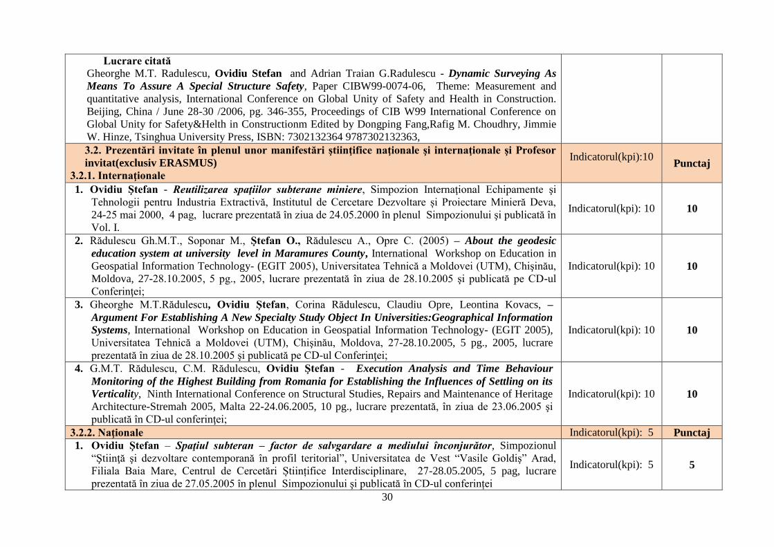
30
Lucrare citată
Gheorghe M.T. Radulescu, Ovidiu Stefan and Adrian Traian G.Radulescu - Dynamic Surveying As
Means To Assure A Special Structure Safety, Paper CIBW99-0074-06, Theme: Measurement and
quantitative analysis, International Conference on Global Unity of Safety and Health in Construction.
Beijing, China / June 28-30 /2006, pg. 346-355, Proceedings of CIB W99 International Conference on
Global Unity for Safety&Helth in Constructionm Edited by Dongping Fang,Rafig M. Choudhry, Jimmie
W. Hinze, Tsinghua University Press, ISBN: 7302132364 9787302132363,
3.2. Prezentări invitate în plenul unor manifestări ştiinţifice naţionale şi internaţionale şi Profesor
invitat(exclusiv ERASMUS)
3.2.1. Internaţionale
Indicatorul(kpi):10
Punctaj
1. Ovidiu Ştefan - Reutilizarea spaţiilor subterane miniere, Simpozion Internaţional Echipamente şi
Tehnologii pentru Industria Extractivă, Institutul de Cercetare Dezvoltare și Proiectare Minieră Deva,
24-25 mai 2000, 4 pag, lucrare prezentată în ziua de 24.05.2000 în plenul Simpozionului şi publicată în
Vol. I.
Indicatorul(kpi): 10 10
2. Rădulescu Gh.M.T., Soponar M., Ştefan O., Rădulescu A., Opre C. (2005) – About the geodesic
education system at university level in Maramures County, International Workshop on Education in
Geospatial Information Technology- (EGIT 2005), Universitatea Tehnică a Moldovei (UTM), Chişinău,
Moldova, 27-28.10.2005, 5 pg., 2005, lucrare prezentată în ziua de 28.10.2005 şi publicată pe CD-ul
Conferinţei;
Indicatorul(kpi): 10 10
3. Gheorghe M.T.Rădulescu, Ovidiu Ştefan, Corina Rădulescu, Claudiu Opre, Leontina Kovacs, –
Argument For Establishing A New Specialty Study Object In Universities:Geographical Information
Systems, International Workshop on Education in Geospatial Information Technology- (EGIT 2005),
Universitatea Tehnică a Moldovei (UTM), Chişinău, Moldova, 27-28.10.2005, 5 pg., 2005, lucrare
prezentată în ziua de 28.10.2005 şi publicată pe CD-ul Conferinţei;
Indicatorul(kpi): 10 10
4. G.M.T. Rădulescu, C.M. Rădulescu, Ovidiu Ştefan - Execution Analysis and Time Behaviour
Monitoring of the Highest Building from Romania for Establishing the Influences of Settling on its
Verticality, Ninth International Conference on Structural Studies, Repairs and Maintenance of Heritage
Architecture-Stremah 2005, Malta 22-24.06.2005, 10 pg., lucrare prezentată, în ziua de 23.06.2005 şi
publicată în CD-ul conferinţei;
Indicatorul(kpi): 10 10
3.2.2. Naţionale Indicatorul(kpi): 5 Punctaj
1. Ovidiu Ştefan – Spaţiul subteran – factor de salvgardare a mediului înconjurător, Simpozionul
“Ştiinţă şi dezvoltare contemporană în profil teritorial”, Universitatea de Vest “Vasile Goldiş” Arad,
Filiala Baia Mare, Centrul de Cercetări Științifice Interdisciplinare, 27-28.05.2005, 5 pag, lucrare
prezentată în ziua de 27.05.2005 în plenul Simpozionului şi publicată în CD-ul conferinței
Indicatorul(kpi): 5 5
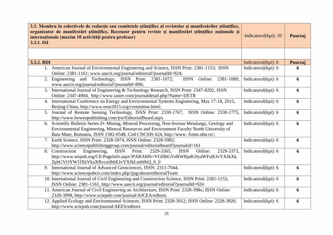
31
3.3. Membru în colectivele de redacţie sau comitetele ştiinţifice al revistelor şi manifesărilor ştiinţifice,
organizator de manifestări ştiinţifice, Recenzor pentru reviste şi manifestări ştiinţifice naţionale şi
internaţionale (maxim 10 activități pentru profesor)
3.3.1. ISI
Indicatorul(kpi): 10 Punctaj
3.3.2. BDI Indicatorul(kpi): 6 Punctaj
1. American Journal of Environmental Engineering and Science, ISSN Print: 2381-1153; ISSN
Online: 2381-1161; www.aascit.org/journal/editorial?journalId=924;
Indicatorul(kpi): 6 6
2. Engineering and Technology; ISSN Print: 2381-1072; ISSN Online: 2381-1080;
www.aascit.org/journal/editorial?journalId=896;
Indicatorul(kpi): 6 6
3. International Journal of Engineering & Technology Research, ISSN Print: 2347-8292, ISSN
Online: 2347-4904, http://www.iaster.com/journaldetail.php?Name=IJETR
Indicatorul(kpi): 6 6
4. International Conference on Energy and Environmental Systems Engineering, May 17-18, 2015,
Beijing China, http://www.eese2015.org/committee.html;
Indicatorul(kpi): 6 6
5. Journal of Remote Sensing Technology, ISSN Print: 2330-1767; ISSN Online: 2330-1775,
http://www.bowenpublishing.com/jrst/EditorialBoard.aspx
Indicatorul(kpi): 6 6
6. Scientific Bulletin Series D- Mining, Mineral Processing, Non-ferrous Metalurgy, Geology and
Environmental Engineering, Mineral Resources and Environment Faculty North University of
Baia Mare, Romania, ISSN 1582-0548, Cod CNCSIS 624, http://www. frmm.ubn.ro/;
Indicatorul(kpi): 6 6
7. Earth Science, ISSN Print: 2328-5974, ISSN Online: 2328-5982;
http://www.sciencepublishinggroup.com/journal/editorialboard?journalid=161
Indicatorul(kpi): 6 6
8. Construction Engineering, ISSN Print: 2329-3365, ISSN Online: 2329-3373,
http://www.seipub.org/CE/PageInfo.aspx?PARAMS=VGl0bGVeRWRpdG9yaWFsIEJvYXJkXk
ZpbGVOYW1lXkVkaXRvcmlhbEJvYXJkLmh0bQ_0_0
Indicatorul(kpi): 6 6
9. International Journal of Advanced Geosciences, ISSN: 2311-7044,
http://www.sciencepubco.com/index.php/ijag/about/editorialTeam
Indicatorul(kpi): 6 6
10. International Journal of Civil Engineering and Construction Science, ISSN Print: 2381-1153,
ISSN Online: 2381-1161, http://www.aascit.org/journal/editorial?journalId=924
Indicatorul(kpi): 6 6
11. American Journal of Civil Engineering an Architecture, ISSN Print: 2328-398x; ISSN Online:
2328-3998, http://www.sciepub.com/journal/AJCEA/editors
Indicatorul(kpi): 6 6
12. Applied Ecology and Environmental Sciences, ISSN Print: 2328-3912; ISSN Online: 2328-3920,
http://www.sciepub.com/journal/AEES/editors
Indicatorul(kpi): 6 6
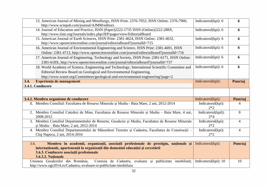
32
13. American Journal of Mining and Metallurgy, ISSN Print: 2376-7952; ISSN Online: 2376-7960,
http://www.sciepub.com/journal/AJMM/editors
Indicatorul(kpi): 6 6
14. Journal of Education and Practice, ISSN (Paper)2222-1735 ISSN (Online)2222-288X,
http://www.iiste.org/Journals/index.php/JEP/pages/view/EditorialBoard
Indicatorul(kpi): 6 6
15. American Journal of Earth Sciences, ISSN Print: 2381-4624, ISSN Online: 2381-4632,
http://www.openscienceonline.com/journal/editorialboard?journalId=715
Indicatorul(kpi): 6 6
16. American Journal of Environmental Engineering and Science, ISSN Print: 2381-4691, ISSN
Online: 2381-4713, http://www.openscienceonline.com/journal/editorialboard?journalId=716
Indicatorul(kpi): 6 6
17. American Journal of Engineering, Technology and Society, ISSN Print: 2381-6171, ISSN Online:
2381-618X, http://www.openscienceonline.com/journal/editorialboard?journalId=737
Indicatorul(kpi): 6 6
18. World Academy of Science, Engineering and Technology, International Scientific Committee and
Editorial Review Board on Geological and Environmental Engineering,
http://www.waset.org/Committees/geological-and-environmental-engineering?page=2
Indicatorul(kpi): 6 6
3.4. Experienţa de management
3.4.1. Conducere
Indicatorul(kpl): Punctaj
3.4.2. Membru organisme de conducere Indicatorul(kpi): Punctaj
1. Membru Consiliul: Facultatea de Resurse Minerale şi Mediu - Baia Mare, 2 ani, 2012-2014 Indicatorul(kpi):
2*2
4
2. Membru Consiliul Catedrei de Mine, Facultatea de Resurse Minerale şi Mediu – Baia Mare, 4 ani,
2008-2012
Indicatorul(kpil):
2*4
8
3. Membru Consiliul Departamentului de Resurse, Geodezie şi Mediu, Facultatea de Resurse Minerale
şi Mediu – Baia Mare, 2 ani, 2012-2014
Indicatorul(kpi):
2*2
4
4. Membru Consiliul Departamentului de Măsurători Terestre și Cadastru, Facultatea de Construcții –
Cluj Napoca, 2 ani, 2014-2016
Indicatorul(kpi):
2*2
4
3.6. Membru în academii, organizații, asociații profesionale de prestigiu, naționale și
internaționale, apartenență la organizații din domeniul educației și cercetării
3.6.3. Conducere asociații profesionale
3.6.3.2. Naționale
Indicatorul(kpi): Punctaj
Uniunea Geodezilor din România, Comisia de Cadastru, evaluare și publicitate imobiliară;
http://www.ugr2014.ro/Cadastru,-evaluare-si-publicitate-imobiliara
Indicatorul(kpi): 10 10
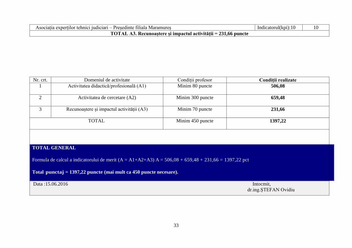
33
Asociația experților tehnici judiciari – Președinte filiala Maramureș Indicatorul(kpi):10 10
TOTAL A3. Recunoaştere şi impactul activităţii = 231,66 puncte
Nr. crt. Domeniul de activitate Condiții profesor Condiții realizate
1 Activitatea didactică/profesională (A1) Minim 80 puncte 506,08
2 Activitatea de cercetare (A2) Minim 300 puncte 659,48
3 Recunoaștere și impactul activității (A3) Minim 70 puncte 231,66
TOTAL Minim 450 puncte 1397,22
TOTAL GENERAL
Formula de calcul a indicatorului de merit (A = A1+A2+A3) A = 506,08 + 659,48 + 231,66 = 1397,22 pct
Total punctaj = 1397,22 puncte (mai mult ca 450 puncte necesare).
Data :15.06.2016 Intocmit,
dr.ing.ȘTEFAN Ovidiu